Baiersbronn Schau ins Land

This route was brought to you by:
RouteXpert Hans van de Ven (Mr.MRA)
Last edit: 16-04-2021
 Route Summary
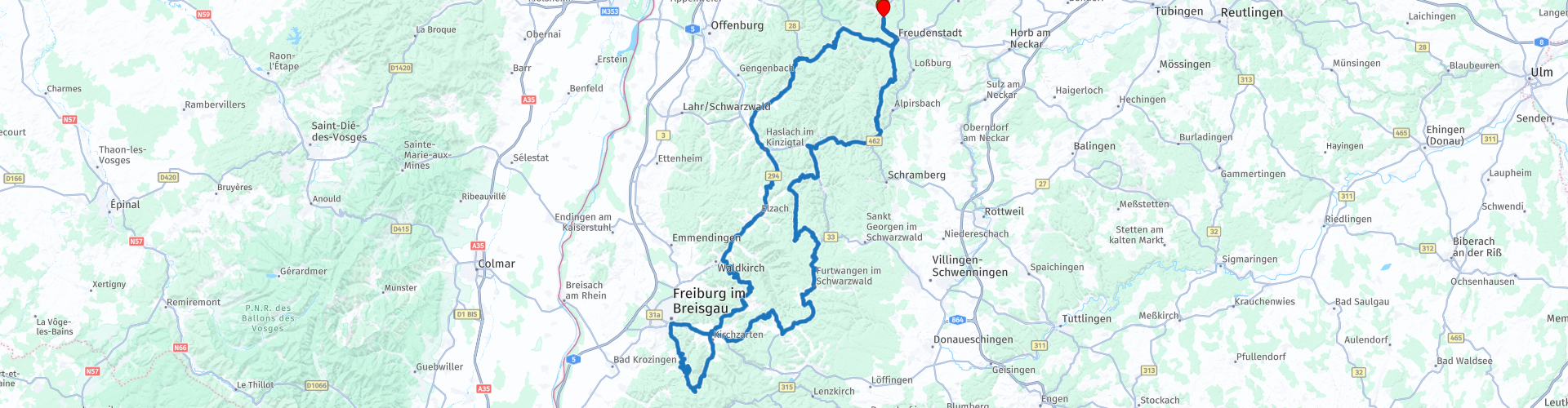
 Starting point and end point: Hotel Falken Baiersbronn.
Route made equal for Garmin, TT and MyRoute-app Navigation.
 Share this route


Animation

Verdict


Duration
7h 50m

Mode of travel
Car or motorcycle

Distance
295.31 km

Countries

 RouteXpert Review
 The route is mainly on beautiful roads and after a short 1H30M winding we stop at Bäckerei Backhäusle for a cup of coffee. After coffee we wind further towards Schau in Land, after again many beautiful bends, descents and climbs we arrive at Schau ins Land *, also the lunch location for today.
* The Schauinsland is a 1,284 meter high mountain near Freiburg im Breisgau, Baden-Württemberg. In the autumn, views are possible over the clouds to the Vosges and the Alps. The top of the mountain can be reached on a twelve kilometer long road full of hairpin bends. From 1923 to 1984 ADAC organized the Schauinsland-Rennen on this road. Since 2000, this race has been held every two years with old cars built before 1984, the Schauinsland Klassik. A cable car has been running from the valley station "Horben" to the summit since 1930. The track is 3600 meters long, the ride takes 15 minutes.
On April 17, 1936, a group of English school children walked on the Schauinsland. They ended up in a sudden snowstorm and became disoriented. They split into two groups. One group reached the valley after which a major search for the others was started, of which five lost their lives. In memory of these children a monument was placed in 1938. (Source: Wikipedia).
After lunch we wind the 12 KM down towards Freiburg, one hairpin bend after the other looms. This road is closed to motorbikes on Saturdays and Sundays!
When we arrive in Freiburg, we have to deal with some road works and we have to get off the route for a while, what traffic, while in the majority of the Black Forest we hardly encounter any traffic.
As soon as we are back on the route, we drive on and we arrive at Kandel, this is a beautiful viewpoint and also starting point for hanggliders. Here we stop again to take some pictures. The winding road down is very nice, but the road surface is very bad, I suspect this part of the L186, between Kandel and Waldkirch, will soon be closed to be replaced.
We drive on and stop again for a cup of coffee at the Imbiss Löcherbergwasen in Oberharmersbach. In this route you will again use the B500, the Schwarzwaldhochstraße **.
** The Schwarzwaldhochstraße is an impressive, wide road that runs right through the Black Forest. Another well-known name for this route is also B500. The winding route goes through the nature park and runs from Baden-Baden to Freudenstadt, at altitudes from 800 meters to one kilometer. The road offers visitors an enchanting view of the Rhine Valley and the Vosges, among other places. Not to be forgotten is that the beautiful nature certainly invites you to walk, take pictures and enjoy the sights along this route.
Just through Freudenstad and refuel in Baiersbronn before we are back at the hotel
Because we drove this route ourselves, we rate it with 5 stars.


 Links
Links  Usage
Usage Want to download this route?
You can download the route for free without MyRoute-app account. To do so, open the route and click 'save as'. Want to edit this route?
No problem, start by opening the route. Follow the tutorial and create your personal MyRoute-app account. After registration, your trial starts automatically.  Disclaimer
Use of this GPS route is at your own expense and risk. The route has been carefully composed and checked by a MyRoute-app accredited RouteXpert for use on TomTom, Garmin and MyRoute-app Navigation.
Changes may nevertheless have occurred due to changed circumstances, road diversions or seasonal closures. We therefore recommend checking each route before use.
Preferably use the route track in your navigation system. More information about the use of MyRoute-app can be found on the website under 'Community' or 'Academy'.