R16 Roundtour Sirkka to North Cape part 2

This route was brought to you by:
RouteXpert Arno van Lochem - Senior RX
Last edit: 26-08-2021
 Route Summary
 You can also see this sixteenth part as part 2 of a 5-part tour from Sirkka to the North Cape.
The routes are easy for everyone to drive and are on well-paved roads. It may be necessary to take a single hairpin bend, but these are perfectly doable.
If there is a piece of gravel in the route, a warning will be given and, if possible, a detour will be indicated.
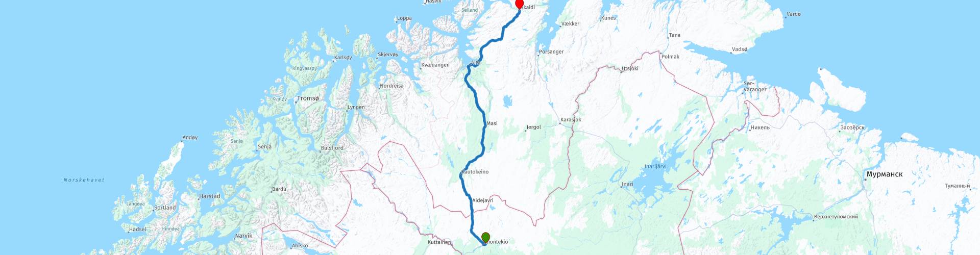
The route starts in Enontekiö, located in Finnish Lapland. The route again runs through a vast area, in which conifers, mountain birch trees and lakes provide your view. Some nice sights along the way, including a few nice waterfalls. You soon cross the Norwegian border, so most of the route passes through Norwegian territory. The route ends in Skaidi, from there it is another 150 kilometers to the North Cape.
The North Cape is therefore getting closer!
The expansive landscape is the reason that you better have some food and drink with you on the go, as the catering establishments in this area are not particularly abundant.
Vast landscape and beautiful views, beautiful roads and interesting sights, hence the 4-star rating.
 Share this route


Animation

Verdict


Duration
7h 48m

Mode of travel
Car or motorcycle

Distance
300.01 km

Countries


 RouteXpert Review
 Of all western European countries, the Scandinavian countries probably have the most more or less untouched nature. In addition, they are countries that are easily accessible from the Netherlands. Norway is characterized by, among other things, the fjords and the Trollstigen, known to many motorcyclists. And where Sweden is known as wide and relaxing, everyone knows Finland as the land of 1000 lakes. All in all, legitimate reasons to traverse this beautiful nature in the north of Europe by means of a number of routes.
The route starts in Enontekiö, located in the far north of Finnish Lapland. After less than a mile you will pass a supermarket. It is wise to stock up on some food and drink for the road. There are not extensive catering establishments along much of the route. If you stand in front of a closed door somewhere, you have at least something with you.
A few hundred meters away you will pass a gas station, if you do not have the tank full you can still do so here.
After driving 40 kilometers through the Finnish part of Lapland past countless lakes you arrive at the border with Norway. The first kilometers in Norway look no different than in Finland. Low trees, extensive landscape and water, lots of water. There are several points where you can stop for a while to stretch your legs and take a look at the surroundings.
The first coffee stop is planned in Kautokeino at restaurant Duottar. Judging by the snowmobiles in the parking lot, it can snow seriously here. Of course it is wonderful to ride or slide through the landscape on such a thing.
After the coffee break, you drive further north and you pass Cábardasjohka dam, an electricity plant. This river power plant is owned and operated by Ymber AS. The power plant uses a drop of approximately 5.5 meters about 2 kilometers from the outlet to the Kautokeino River. The plant previously had a regulation reservoir in Stuorajavri, about 15 kilometers north of the plant. By raising the water level by 1 meter, a reservoir volume of 21.5 million m³ was achieved here. The regulation dam was destroyed by the spring flood in 1968 and was not later rebuilt. The plant has a vertical Kaplan turbine (diameter 1.8 m, 14 m³ / s, 250 rpm) that generates 725 kVA / 400 Volt. The annual production is 4-4.5 GWh.
A few dozen kilometers further on you will pass the Pikefossen waterfall. This is the only waterfall (8 meters) on the Kautokeino / Alta River.
The name is derived from a Sami legend of a girl herding reindeer while her master was traveling. The whole herd of reindeer drowned. When her master returned and saw what had happened, he threw the maid into the waterfall, hence the name. There is a picnic area and toilets.
You will also pass the point where the Trangdaselva flows into the Altaelva River. Especially when the river has a high flow at that time, it is a spectacular sight, beautiful to see. Just after the bridge there is a place where you can park.
The Altaelva is the third longest river in the province of Troms og Finnmark. The river starts in the mountains and lakes in the municipality of Kautokeino, near the border with the province of Troms og Finnmark and Finland, just south of the Reisa National Park. The 150-mile river then runs north to the municipality of Alta, where it flows into the Altafjorden in the town of Alta. The river carved out Sautso, one of the largest canyons in Europe on its way from the high Finnmarksvidda plateau to the sea.
In the 1970s and 1980s, the river was the site of the Alta controversy over the construction of a hydroelectric power station. The Alta power station was finally built in 1987, creating Lake Virdnejávri on the river.
The river is one of the best salmon rivers in Norway, known for its large salmon. In the past, salmon up to 33 kg were recorded and up to 24 kg are still caught. In 2011, 1082 salmon weighing 7 kilograms or more were caught on the river.
The Altaelva literally means the "Alta river". The Northern Sami language version of the name is Álttáeatnu and the Kven language version of the name is Alattionjoki. The part of the river that is upstream (south) of the Alta Dam is also called Kautokeinoelva, which means the "Kautokeino River" as that part of the river is in Kautokeino. That part of the river is also known as Guovdageaineatnu or Eatnu in the Northern Sami language.
At Alta you reach the coast, where you look out over the Altafjorden. This fjord is named after Alta, where, as mentioned, the Altaelva also flows into the sea. A coffee break and a refueling stop are planned in Alta. Shortly after the refueling stop, you can see the mouth of the Altaelva in the fjord from the bridge.
In Alta you will also find the Alta Museum. Dive into the history of Alta and the surrounding nature reserves on a trip to the Alta Museum. See rock art that is thousands of years old, learn about the spectacular Northern Lights, and learn about the origins of the city market in the 15th century.
Highlights of the museum include old panels and boulders with rock art. The museum also contains one of five examples of outdoor rock art declared a World Heritage Site by UNESCO. From the museum there are hiking trails through the area along a small bay.
When you return to the museum, you can continue your tour of the museum at one of the numerous exhibitions. For example, explore the history of the Alta market, which has been around since the 15th century. In addition to detailed maps of the trade between Alta and the rest of Northern Europe, you can also view photos of life in the market at the beginning of the 20th century.
On the way to the end of the route you will pass a number of nice places to stop, for example Rasfsnesbukta and Leirbotnvannet. At both places you have a nice view over the water. The latter lake is the source of the Leirbotnelva (Lakselva), which flows into the Altafjord at Leirbotn. The Leirbotnelva was protected from current development in Conservation Plan IV for watercourses in 1993.
After about 300 water-rich kilometers you will reach the end of this route, the Skaidi hotel in Skaidi. A well-appreciated hotel with a bar, restaurant and sauna.
The midnight sun is also clearly visible in the north of Norway. The midnight sun never completely disappears; however the sun sinks quite low and floats just above the horizon. The sun now hangs for several hours between sunset and sunrise, radiating a soft glow: a dream come true for every photographer. Shady silhouettes against a golden sky with beautiful nature all around you, that is an experience that many people would love to experience.
In the north of Norway, the midnight sun shines from the end of May to mid-July. However, a warning is in order, exposure to this phenomenon can disrupt your sleep cycle.
For campers, two campsites are indicated in the vicinity of the end point: Repparfjord Camping og Misjonssenter and Russenes Camping. The latter is more than 20 kilometers away.
Have fun driving this route!


 Links
Links  Usage
Usage Want to download this route?
You can download the route for free without MyRoute-app account. To do so, open the route and click 'save as'. Want to edit this route?
No problem, start by opening the route. Follow the tutorial and create your personal MyRoute-app account. After registration, your trial starts automatically.  Disclaimer
Use of this GPS route is at your own expense and risk. The route has been carefully composed and checked by a MyRoute-app accredited RouteXpert for use on TomTom, Garmin and MyRoute-app Navigation.
Changes may nevertheless have occurred due to changed circumstances, road diversions or seasonal closures. We therefore recommend checking each route before use.
Preferably use the route track in your navigation system. More information about the use of MyRoute-app can be found on the website under 'Community' or 'Academy'.
Lapland
About this region
Lapland may refer to:
Read more on Wikipedia
View region
 Statistics
  6
6Amount of RX reviews (Lapland)
 8002
8002Amount of visitors (Lapland)
 299
299Amount of downloads (Lapland)
 Route Collections in this region
 6500 kilometers through Scandinavia with the highlights of the Lofoten and the North Cape
The Arctic Challenge Tour, on which this 26-part tour is partly based, is not a speed race. It's a tour. It comes down to agility, good navigation and anticipation. The participants are obliged to adhere to the speed limit of the country concerned. The participants must find the ideal route with the shortest possible distance by complying 100% with the locally applicable traffic rules. Of course, also take maximum speeds into account. The organization checks for violations of the speed limit. In case of gross or repeated exceeding of the maximum speed, disqualification for the relevant stage and for the final classification will follow. Control of the route and speeds is done by means of a track and trace system. This equipment is installed in every vehicle. You can then follow each team accurately in the Back Office. Those staying at home, interested parties and participants can also see the performances of the teams, because you can be followed live via the Internet. The Back Office takes action when a team gets into trouble. (source: website The Arctic Challenge)
That's quite a luxury, having a back office behind you that keeps an eye on you. Most of us will not have that and are on our own or the fellow traveler(s). The only agreement you have with the participants is that you also have to abide by the rules. Fortunately, you don't have to complete this tour in 9 days, like the participants, but you can take it a little longer.
The highlight of the Arctic Challenge in 2020 was the Lofoten, an island group northwest of Norway. The Lofoten archipelago is located in the middle of the wild Norwegian Sea, well above the Arctic Circle. This special region offers a beautiful landscape with imposing mountains, deep fjords and long, wild sandy beaches where the sound of the seabird colonies can always be heard.
The archipelago is best known for its rich fishing tradition. The Lofoten makes a prosperous impression despite their isolated location. The entire economy revolves above all around fishing. The image of the Lofoten is mainly dominated by wooden racks with cod, which hangs to dry. Lofoten fishing has been a household name for centuries. In the middle of winter, the ships set out to catch the fish in just a few months. The rich fishing grounds are due to the North Atlantic Warm Gulf Stream around the islands, in which the fish have their spawning grounds. Oil drilling is not permitted around Lofoten and the cod spawning grounds there.
The next destination for the participants was Sirkka, also known as Levi, a winter sports resort in Finnish Lapland. They stayed there for a few days to go ice-karting and to enjoy the snow by going on a snowmobile or skiing trip. This tour also takes you to Sirkka, but instead of staying there for a few days, you have the option to continue to the North Cape, the second highlight of this trip.
Imagine a place in the far north, where the Atlantic Ocean meets the icy waters of the Arctic Ocean. This place is the North Cape in Western Finnmark in Northern Norway. From here, only the archipelago of Spitsbergen lies between you and the North Pole and the sun shines for 2.5 months at a time; from mid-May to the end of July. Many visitors admire the midnight sun or the sunset over the Barents Sea from the North Cape plateau.
With each route you will find a review with a description of the route, where you pass and what to see along the way. It is also briefly described how the participants in the Arctic Challenge in 2020 had to drive it anyway, from which point to which point. Along the way, markings (route points) have been included that indicate the end points of the stages that the participants had to complete. As mentioned, they covered the distance in 9 days, stages of more than 1000 kilometers were no exception.
Each route ends at a hotel. It is of course not an obligation to use these hotels, you can always find another place to stay in the area, that decision is up to you. My experience, however, is that they are all simple but good hotels for a very reasonable price. They are known and can be booked at booking.com.
The routes of these collections:
R01 - Puttgarden to Angelholm, 280km
R02 - Angelholm to Alingsas, 281km
R03 - Alingsas to Mysen, 261km
R04 - Mysen to Rena, 312km
R05 - Rena to Orkanger, 306km
R06 - Orkanger to Grong, 292km
R07 - Grong to Mo i Rana, 290km
R08 - Mo i Rana to Bodo, 231km
R09 - Roundtour Bodo to Lofoten part 1, 314km
R10 - Roundtour Bodo to Lofoten part 2, 250km
R11 - Roundtour Bodo to Lofoten part 3, 291km
R12 - Bodo to Arjeplog, 295km
R13 - Arjeplog to Jokkmokk, 244km
R14 - Jokkmokk to Pajala, 239km
R15 - Roundtour Sirkka to North Cape part 1, 257km
R16 - Roundtour Sirkka to North Cape part 2, 300km
R17 - Roundtour Sirkka to North Cape part 3, 244km
R18 - Roundtour Sirkka to North Cape part 4, 275km
R19 - Roundtour Sirkka to North Cape part 5, 332km
R20 - Sirkka to Kemi, 299km
R21 - Kemi to Ylivieska, 251km
R22 - Ylivieska to Jalasjarvi, 236km
R23 - Jalasjarvi to Turku, 279km
R24 - Stockholm to Askersund, 271km
R25 - Askersund to Varnamo, 224
R26 - Varnamo to Trelleborg, 259km
Have fun driving these routes!
View Route Collection