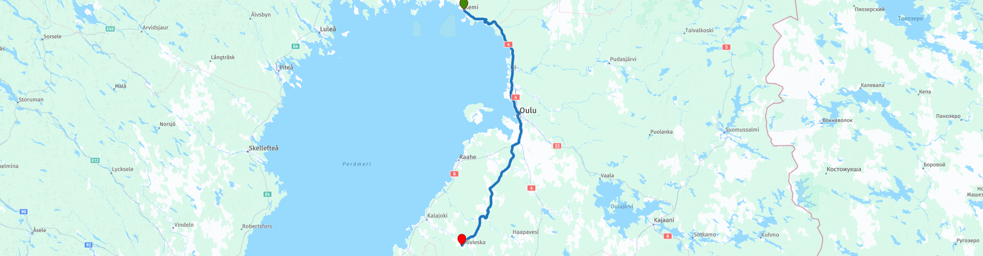
R21 Kemi to Ylivieska

This route was brought to you by:
RouteXpert Arno van Lochem - Senior RX
Last edit: 20-05-2021
 Route Summary
 The routes are easy for everyone to ride and are on well-paved roads. There may be a single hairpin bend to be taken, but these are easy to do.
If there is a piece of gravel in the route, a warning will be given and, if possible, a detour will be indicated.
The route starts in Kemi, located on the Gulf of Bothnia. Along the way fantastic landscapes, lots of water and beautiful views, making the road great. Nice to drive. After every turn a different fantastic view. Beautiful and interesting sights include a point where you have a beautiful view over the Gulf of Bothnia, the Oulu Automobile Museum and the Tietomaa Scientific Center.
Beautiful rugged landscape, beautiful scenic views, tight roads and beautiful sights, hence the 4-star rating.
 Share this route


Animation

Verdict


Duration
8h 4m

Mode of travel
Car or motorcycle

Distance
251.17 km

Countries

 RouteXpert Review
 Of all western European countries, the Scandinavian countries probably have the most more or less untouched nature. In addition, they are countries that are easily accessible from the Netherlands. Norway is characterized by, among other things, the fjords and the Trollstigen known to many motorcyclists. And where Sweden is known as wide and peaceful, everyone knows Finland as the land of 1000 lakes. All in all, legitimate reasons to traverse this beautiful nature in the north of Europe by means of a number of routes.
After having visited the great highlights of this tour, you will descend further south on this route. The route starts in Kemi, a place with more than 20,000 inhabitants, located on the Gulf of Bothnia.
Shortly after the start you will pass a gas station where you can fill the tank if necessary. You can also buy some food and drinks in the shop for on the go. Although there is a reasonable opportunity to stop for food and / or drinks along the way, you will occasionally drive through areas where it is less populated.
Just before you reach Simo you will pass a separate attraction. A road that has been awarded the museum stamp. Simonkyläntie is a museum road in Simo in the province of Lapland. The road is 1.8 miles long and leads from Sinikoski through Simonkylä to the mouth of the Simojoki River. As a museum road, it represents the historic Ostrobothnian coastal road. The road was included in the museum road collection in 1982.
The Ostrobothnic coastal road led along the coast to Oulu, Kemi and Tornio to Stockholm. The road was being used to transport mail between Turku and Stockholm when a storm blocked the use of the Great Post Road, which ran through Åland. The order to clear the cavalry track was issued in 1652 and a hundred years later an order was issued to bring the path to a rough condition - King Adad Fredrik of Sweden made a trip to Finland in 1752 and walked it off.
Just below Kuivanimie you will pass a place where you have a beautiful view over the Gulf of Bothnia. The Gulf of Bothnia is the northernmost part of the Baltic Sea. The sea is located between the west coast of Finland and the east coast of Sweden. In the south of the gulf are the Åland archipelago and the Åland Sea. There is a narrowing in the middle; this is called 'Kvarken'.
The Gulf has a maximum length of 725 kilometers and is between 80 and 240 kilometers wide. The average depth is 60 meters, although the deepest point is 295 meters below sea level. The Golf has an area of 117,000 km².
The Gulf of Bothnia is special because its salinity decreases rapidly towards the north. In the south the water is the normal brackish water of the Baltic Sea, but in the north the Gulf has a salinity so low (0.2%) that one can no longer taste the salt in the water and many freshwater fish thrive in it . This can be explained by the fact that many rivers pour fresh water into the Gulf of Bothnia, because hardly any water evaporates due to its northern location and because there is only a close connection with the ocean at a great distance.
The Gulf of Bothnia is frozen for five months in the year. Due to the more northerly location and the lower salinity, the northern part freezes first and is released last. In the period from mid-December to mid-May, ships are only allowed to enter the Gulf of Bothnia accompanied by icebreakers. In March the ice cover reaches its maximum extent, on average about 204,000 km² is covered with ice. In harsh winters, the ice surface doubles to about 420,000 km². In the summer all the ice melts.
For the beautiful view you have to walk a short walk, but it is definitely worth it!
In Oulu you will pass the Science Center. This Center has been offering visitors unforgettable experiences since 1988. Finland's first science center is the perfect place to learn, enjoy, test your brain and body, or simply spend some time entertaining research. Science Center Tietomaa is a household name in Oulu and all of Northern Finland. It has been one of the most famous attractions in Oulu for years. Many generations have visited it with school groups or their families with a total of over a million visits to date - and many come back year after year.
The science centre's themed exhibitions offer more than 150 hands-on attractions and demonstrations. New exhibitions are opened every year and highlights from previous exhibitions become part of the permanent exhibition. The exhibitions explore different areas of science and technology and provide food for thought for all audiences. The marine themed exhibit called MOB gives you a taste of salt water and lets you experience breathtaking speed. Try out magical sandy landscapes, test your skill in a sailing competition and try the speedboat simulator - but don't get yourself seasick!
The Science Centre's gigantic cinema shows fantastic 3D films that take audiences to the depths of the oceans, the darkest jungles, the endless reaches of space, or back in time to see the dinosaurs. The digital science films are produced by the best producers of gigantic screen content in the world and are guaranteed to take your breath away. The giant screen theater has the second largest screen in Finland. The 153 square meters brings the action close and makes it lifelike.
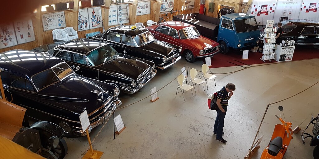
A little further you will come to the Oulu Automobile Museum where you will find a (private) collection of more than 50 cars and motorcycles. The oldest cars date from around 1910. Come in and enjoy the predecessors of your own car or motorcycle!
The museum is maintained by an enthusiastic group of volunteers called 'Oulu Seudun Mobilistit r.y'. You will find the museum about four kilometers north of Oulu. Definitely worth a visit!
The route winds further through the Finnish landscape until you finally arrive in Ylivieska. This is a town near the border of Central and North Ostrobothnia. Ylivieska is a city that grew up at the crossroads of railways, on the banks of the Kalajoki River. The city has over 15,000 inhabitants and an area of over 573 km².
The route ends at Hotel Käenpesä. A nice hotel with a bar, restaurant. A debriefing of the route while enjoying a beer is therefore certainly possible. If you would like to visit the sauna, this is also possible in this hotel.
For the camper there is a campsite in the vicinity (20 km away!) From the end point: Top Camping Kalajoki
Have fun driving this route!

 Links
Links  Usage
Usage Want to download this route?
You can download the route for free without MyRoute-app account. To do so, open the route and click 'save as'. Want to edit this route?
No problem, start by opening the route. Follow the tutorial and create your personal MyRoute-app account. After registration, your trial starts automatically.  Disclaimer
Use of this GPS route is at your own expense and risk. The route has been carefully composed and checked by a MyRoute-app accredited RouteXpert for use on TomTom, Garmin and MyRoute-app Navigation.
Changes may nevertheless have occurred due to changed circumstances, road diversions or seasonal closures. We therefore recommend checking each route before use.
Preferably use the route track in your navigation system. More information about the use of MyRoute-app can be found on the website under 'Community' or 'Academy'.

Noord Ostrobotnie
About this region
View region
 Statistics
  2
2Amount of RX reviews (Noord Ostrobotnie)
 3707
3707Amount of visitors (Noord Ostrobotnie)
 142
142Amount of downloads (Noord Ostrobotnie)
 Route Collections in this region
 6500 kilometers through Scandinavia with the highlights of the Lofoten and the North Cape
The Arctic Challenge Tour, on which this 26-part tour is partly based, is not a speed race. It's a tour. It comes down to agility, good navigation and anticipation. The participants are obliged to adhere to the speed limit of the country concerned. The participants must find the ideal route with the shortest possible distance by complying 100% with the locally applicable traffic rules. Of course, also take maximum speeds into account. The organization checks for violations of the speed limit. In case of gross or repeated exceeding of the maximum speed, disqualification for the relevant stage and for the final classification will follow. Control of the route and speeds is done by means of a track and trace system. This equipment is installed in every vehicle. You can then follow each team accurately in the Back Office. Those staying at home, interested parties and participants can also see the performances of the teams, because you can be followed live via the Internet. The Back Office takes action when a team gets into trouble. (source: website The Arctic Challenge)
That's quite a luxury, having a back office behind you that keeps an eye on you. Most of us will not have that and are on our own or the fellow traveler(s). The only agreement you have with the participants is that you also have to abide by the rules. Fortunately, you don't have to complete this tour in 9 days, like the participants, but you can take it a little longer.
The highlight of the Arctic Challenge in 2020 was the Lofoten, an island group northwest of Norway. The Lofoten archipelago is located in the middle of the wild Norwegian Sea, well above the Arctic Circle. This special region offers a beautiful landscape with imposing mountains, deep fjords and long, wild sandy beaches where the sound of the seabird colonies can always be heard.
The archipelago is best known for its rich fishing tradition. The Lofoten makes a prosperous impression despite their isolated location. The entire economy revolves above all around fishing. The image of the Lofoten is mainly dominated by wooden racks with cod, which hangs to dry. Lofoten fishing has been a household name for centuries. In the middle of winter, the ships set out to catch the fish in just a few months. The rich fishing grounds are due to the North Atlantic Warm Gulf Stream around the islands, in which the fish have their spawning grounds. Oil drilling is not permitted around Lofoten and the cod spawning grounds there.
The next destination for the participants was Sirkka, also known as Levi, a winter sports resort in Finnish Lapland. They stayed there for a few days to go ice-karting and to enjoy the snow by going on a snowmobile or skiing trip. This tour also takes you to Sirkka, but instead of staying there for a few days, you have the option to continue to the North Cape, the second highlight of this trip.
Imagine a place in the far north, where the Atlantic Ocean meets the icy waters of the Arctic Ocean. This place is the North Cape in Western Finnmark in Northern Norway. From here, only the archipelago of Spitsbergen lies between you and the North Pole and the sun shines for 2.5 months at a time; from mid-May to the end of July. Many visitors admire the midnight sun or the sunset over the Barents Sea from the North Cape plateau.
With each route you will find a review with a description of the route, where you pass and what to see along the way. It is also briefly described how the participants in the Arctic Challenge in 2020 had to drive it anyway, from which point to which point. Along the way, markings (route points) have been included that indicate the end points of the stages that the participants had to complete. As mentioned, they covered the distance in 9 days, stages of more than 1000 kilometers were no exception.
Each route ends at a hotel. It is of course not an obligation to use these hotels, you can always find another place to stay in the area, that decision is up to you. My experience, however, is that they are all simple but good hotels for a very reasonable price. They are known and can be booked at booking.com.
The routes of these collections:
R01 - Puttgarden to Angelholm, 280km
R02 - Angelholm to Alingsas, 281km
R03 - Alingsas to Mysen, 261km
R04 - Mysen to Rena, 312km
R05 - Rena to Orkanger, 306km
R06 - Orkanger to Grong, 292km
R07 - Grong to Mo i Rana, 290km
R08 - Mo i Rana to Bodo, 231km
R09 - Roundtour Bodo to Lofoten part 1, 314km
R10 - Roundtour Bodo to Lofoten part 2, 250km
R11 - Roundtour Bodo to Lofoten part 3, 291km
R12 - Bodo to Arjeplog, 295km
R13 - Arjeplog to Jokkmokk, 244km
R14 - Jokkmokk to Pajala, 239km
R15 - Roundtour Sirkka to North Cape part 1, 257km
R16 - Roundtour Sirkka to North Cape part 2, 300km
R17 - Roundtour Sirkka to North Cape part 3, 244km
R18 - Roundtour Sirkka to North Cape part 4, 275km
R19 - Roundtour Sirkka to North Cape part 5, 332km
R20 - Sirkka to Kemi, 299km
R21 - Kemi to Ylivieska, 251km
R22 - Ylivieska to Jalasjarvi, 236km
R23 - Jalasjarvi to Turku, 279km
R24 - Stockholm to Askersund, 271km
R25 - Askersund to Varnamo, 224
R26 - Varnamo to Trelleborg, 259km
Have fun driving these routes!
View Route Collection