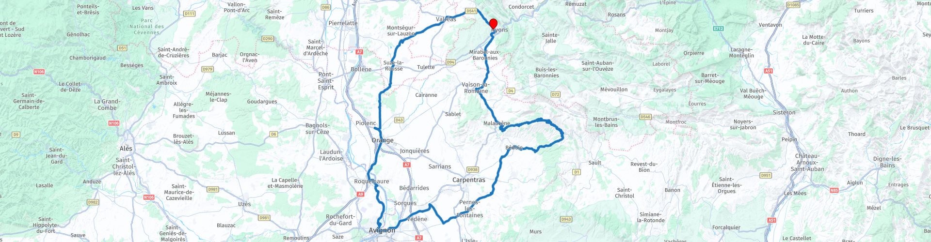
Roundtrip Nyons to Nyons passing by Orange and Avignon

This route was brought to you by:
RouteXpert Catherine De Groote RouteXpert
Last edit: 20-11-2021
 Route Summary
 The Roman theater of Orange, the Palais des Papes in Avignon and the archaeological sites in Vaison-la-Romaine are on the to-do list on this drive. The first part runs along the olive groves of the 'Olive noire de Nyons', protected by a Controlled Designation of Origin (AOC) since 1994. The Rhone Valley is the oldest wine region in France. Leaving the vineyards behind, you will pass the beautiful lavender fields that bloom from mid-June to mid-August. Another detour over the Mont Ventoux - which you can hardly ignore now that you pass at its foot - takes you back to the natural park of the Baronnies Provençales. Where possible, follow the green Michelin roads. But the other roads also offer a lot of beauty and are in excellent condition. This ride gets 5 stars.
 Share this route


Animation

Verdict


Duration
8h 41m

Mode of travel
Car or motorcycle

Distance
203.40 km

Countries

 RouteXpert Review
 Immense vineyards and lavender fields are the backdrop through which you drive. The roads are quiet and you can fully enjoy this beautiful landscape.
The town of Suze-la-Rousse, the main town of the historic region of Tricastin in the Middle Ages, owes its name to the location, the altitude and the ocher colored stones of the 12th-century castle built by the Baux family. Over the centuries, it continues to develop and provides itself with a covered square in the 18th century. Enclave in the Vaucluse since the early 19th century, it is today appreciated for its architectural charm, but also for its production of Côtes du Rhône wines.
You immediately notice that this is a wine region on your drive further towards Orange: vineyards, vineyards and more vineyards…
Pay attention when you come to the N7. You have to turn left here towards Orange. Garmin makes a mistake here.
Orange, a former Roman town, has two special antique monuments from the 1st century of our era, which are now on the Unesco World Heritage List. The Roman theater, built during the reign of Emperor Augustus, is particularly well preserved, and features an astonishing facade: 103 meters long and 37 meters high! A prime location for theater at the time of the Romans, but still today thanks to the incredible acoustics. But the triumphal arch at the northern entrance to the city is just as beautiful. This monument, one of the most beautiful and interesting surviving examples of a provincial triumphal arch, is a symbol of Roman imperialism; honors the founders of the city (veterans of the 2nd Gallic Legion) and later Emperor Tiberius.
Roquemaure is known for its economy linked to viticulture, with an AOC for Lirac, the premier cru of the Côtes-du-Rhône. The town is also part of the olive oil production area of Provence, also protected by an AOC.
The Rhone rises from the Rhone Glacier at the Furka Pass in the northeast of the Swiss canton of Valais and flows from there in a southwesterly direction. The Rhone flows into Lake Geneva and leaves the lake to cross the border with France a few kilometers more south-west. At Lyon, the Saône joins the river and the Rhône flows definitively further south. On this stretch, lined by vineyards, the Saône, Isère, Drôme, Ardèche, Eygues, Durance and Gard flow into the Rhône. The city of Avignon lies before the mouth of the Durance. Before Arles, the river splits into the Grand-Rhône and the Petit-Rhône. This area is called the Camargue. The Rhone flows into the Golfe du Lion.
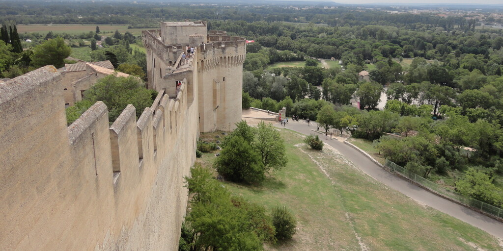
The imposing Fort Saint André in Villeneuve-lès-Avignon is located on Mont Andaon, a rocky outcrop that rises 50 meters above the Rhone plain. This site was already occupied by the Benedictine abbey and the old town of Saint-André when its construction started in the 12th century. Around 1292, King Filip le Bel took on the task of securing the defense against Avignon of this last bastion of the kingdom of France, as well as the main commercial axes he controlled. But it was not until the 14th century, with the creation of the Holy See in Avignon and the creation by the Pope of the Carthusian monastery of Val-de-Bénédiction in 1356, that the site became a real military fortress, 750 meters long with curtain wall, battlements, towers, barracks, prisons and chapel.
From the top of the fortress, one can see the Palais des Papes opposite, the Avignon Bridge that crossed the Rhone at the time, and all the surrounding countryside. Fort Saint-André has been listed as a historic monument since 1903.
Avignon is known by the nickname 'Babylon on the Rhone' for its beautiful historic center and the Palais des Papes. The historic center of Avignon has been a UNESCO World Heritage Site since 1995. The history of this city largely begins in 1309 when Pope Clement V started the Babylonian captivity of the popes. The French king Philip IV convinced Pope Clement V that it was wise to settle in Avignon because of the confusing situation in Rome. This move made the popes completely dependent on the French king until 1377. In 1348 the popes had bought lordship of the city and merged it with the Comtat Venaissin. This was a papal state until the French annexation under Napoleon in 1791. The city was never part of a French province, because in 1790 they were replaced by the well-known departments. Nevertheless, Avignon is on the list of former independent countries on the territory of present-day France.
The Palais des Papes is located right in the historic center of the city and has an area of no less than 15000 square meters. Not far from there is the Pont Saint-Bénezet, better known as le Pont d'Avignon from the song 'Sur le Pont d'Avignon'.
Le Pont Saint-Bénezet originally spanned the Rhone River between Avignon and Villeneuve-lès-Avignon on the left bank. Construction took place between 1171 and 1185. The bridge had an original length of 900 meters. However, due to multiple floods, several parts of the bridge collapsed. As a result, several restorations had to take place. A great flood in 1669 destroyed a large part of the burg. The damage was so great that no further attempts were made to repair the bridge. This led to decay, leaving only four intact of the 22 original arches that once made up the bridge.
The current Palais des Papes consists of two connected buildings. For example, there is the Palais Vieux. This is the old palace that dates from the period 1334-1342. It was built by Pope Benedict XII on the site of the former episcopal palace. Later on, the private papal quarters were built in this part. The towers served to defend the palace during sieges. One of these towers contains a prison, a weapons cellar, coal cellars and storerooms.
By order of Pope Clement VI, the palace was expanded in 1342, the so-called Palais Neuf. The new extension consisted of two wings and a second courtyard. Popes Clement VII (1378-1394) and Benedict XIII (1394-1409) ruled from the Palais des Papes. In 1403 Pope Benedict XIII fled Avignon. His supporters held out in the palace until 1411, but the complex was badly damaged by the sieges. During the reign of Napoleon Bonaparte it was used as a barracks and prison. It became a museum in 1906 and has been restored ever since. Since 1995, the Palace of the Popes has been included on the World Heritage list, along with the immediately surrounding part of the historic center of the city.
Opposite the Palais des Papes you can enjoy seasonal dishes with fresh products in restaurant Le Moutardier du Pape. Or feel free to drop by for a cup of coffee, a homemade ice cream or a snack platter. There are many other restaurants in the immediate vicinity, some cheaper than others.
Pernes-les-Fontaines is a special town with 40 fountains: colossal or discreet, with masked heads, covered with moss or sculpted... The town walls have remained intact, and still have gates, such as those of Notre-Dame from the 14th century equipped with 2 towers on the river. The bell tower, the last vestige of the castle of the Counts of Toulouse, dates from the 12th century.
You can stop for a coffee or drink on the terrace of Portail de l'Olivier in Bédoin. It can be fairly busy, especially in the summer months when the town is overrun by cycling tourists.
The Mont Ventoux beckons in Bédoin. Please note: you must disable 'Seasonal Closures' as Mont Ventoux is closed in the winter months. The Ventoux lives up to its name. The word 'vent' means wind in French. The road on this mountain is regularly closed because it is too windy. Wind speeds of up to 300 kilometers per hour (!) have been measured. The Mont Ventoux is the highest peak for miles around. His nickname the 'giant of Provence' makes complete sense. The fact that this mountain is so high above its surroundings also provides a meteorologically special climate.
The fantastic road meanders wonderfully and quite clearly up. Next to the road you see a beautiful forest with special vegetation. Quite a few shrubs and trees that grow on the Ventoux are quite unique. Just like that road by the way, no traditional hairpin bends here, the road looks more like a meandering river. Once above the forest, the area around Châlet Reynard changes into a lunar landscape. It might be nice to stop here for a while and enjoy a cup of coffee, a soft drink or snack.
About a kilometer before the top you pass the 'Mémorial Tom Simpson'. Simpson was a British cyclist who died during the 1967 Tour de France while climbing Mont Ventoux. 1.4 km before the top he fell off his bike. His sports director put him back on, but Simpson fell again. He lost consciousness, was flown by helicopter to the hospital in Avignon, but died en route. It was the combination of intense heat, dehydration, his never-ending trait, alcohol and amphetamine use that proved fatal.
Just past the bend you pass the 'Monument Brugge-Mont Ventoux'. The organizer of Brugge-Mont Ventoux - Roland Hurtecant - took the initiative to erect this memorial for all cycling tourists who climb the mountain. He organized 40 cycling trips from Bruges to Mont Ventoux.
At the top of Mont Ventoux (1913 m) there is a weather station with a large transmission tower. The view here is phenomenal.
Malaucène is a town located at the foot of the famous Mont Ventoux mountain. The village is one of the three official starting points for the ascent of Mont Ventoux by bicycle. The other villages from which the Mont Ventoux can be climbed are Bédoin and Sault. Malaucène is a typical Provencal village. Every week there is a Provencal market where many regional products are for sale.
Vaison-la-Romaine… A name that makes no secret of its Roman past! With the impressive remains of Villasse and Puymin, this city in Vaucluse has a rich ancient heritage. These two sites, which extend over some fifteen hectares, give a good idea of the size and wealth of the former Gallo-Roman city of Vasio; together they form the largest archaeological site in France! At the Puymin site, the Théo Desplans museum houses fine archaeological collections: marble statues, everyday objects, frescoes and mosaics.
Enjoy the vineyards and olive trees for a while and you will be back in Nyons.

 Links
Links  Usage
Usage Want to download this route?
You can download the route for free without MyRoute-app account. To do so, open the route and click 'save as'. Want to edit this route?
No problem, start by opening the route. Follow the tutorial and create your personal MyRoute-app account. After registration, your trial starts automatically.  Disclaimer
Use of this GPS route is at your own expense and risk. The route has been carefully composed and checked by a MyRoute-app accredited RouteXpert for use on TomTom, Garmin and MyRoute-app Navigation.
Changes may nevertheless have occurred due to changed circumstances, road diversions or seasonal closures. We therefore recommend checking each route before use.
Preferably use the route track in your navigation system. More information about the use of MyRoute-app can be found on the website under 'Community' or 'Academy'.

Auvergne Rhone Alpes
About this region
Auvergne-Rhône-Alpes (ARA; French: [ovɛʁɲ ʁon‿alp] (listen); Arpitan: Ôvèrgne-Rôno-Ârpes; Occitan: Auvèrnhe Ròse Aups; Italian: Alvernia-Rodano-Alpi) is a region in southeast-central France created by the 2014 territorial reform of French regions; it resulted from the merger of Auvergne and Rhône-Alpes. The new region came into effect on 1 January 2016, after the regional elections in December 2015.The region covers an area of 69,711 km2 (26,916 sq mi), making it the third largest in metropolitan France; it had a population of 7,948,287 in 2017, second to Île-de-France. It consists of twelve departments and one territorial collectivity (Lyon Metropolis) with Lyon as the prefecture.
This new region combines diverse geographical, sociological, economic and cultural regions, which was already true of Rhône-Alpes, as well as Auvergne, to a lesser extent. While the old Rhône-Alpes and Auvergne regions each enjoyed a unity defined by axes of communication and the pull of their respective metropoles, the new combination is heterogeneous; it sustained lively opposition from some local officials after its creation.
Read more on Wikipedia
This new region combines diverse geographical, sociological, economic and cultural regions, which was already true of Rhône-Alpes, as well as Auvergne, to a lesser extent. While the old Rhône-Alpes and Auvergne regions each enjoyed a unity defined by axes of communication and the pull of their respective metropoles, the new combination is heterogeneous; it sustained lively opposition from some local officials after its creation.
View region
 Statistics
  118
118Amount of RX reviews (Auvergne Rhone Alpes)
 44879
44879Amount of visitors (Auvergne Rhone Alpes)
 5419
5419Amount of downloads (Auvergne Rhone Alpes)
 Route Collections in this region
 The 24 Most Beautiful Alpine Routes
The Alps, The Alps are a mountain range in Europe, stretching from the French Mediterranean coast in the southwest to the Pannonian Plain in the east. The area of the mountain range is more than 200,000 km².
In other words Passes and Mountain Roads!
Driving through the mountains is great! Especially over the mountain passes with hairpin bends and narrow winding roads. Every bend a different view where you can enjoy. There are many beautiful mountain passes in the Alps.
A selection that has also been incorporated into these routes:
The Stlevio Pass:
The Stelvio Pass, also known as Passo dello Stelvio, is mainly known for the stage in the Giro d'Italia. Due to the length and the difference in height, this pass is seen as one of the toughest tests in cycling. The Stelvio Pass reaches a maximum height of 2758 meters and is therefore one of the highest in the Alps. The pass connects the towns of Bormio and Prato Allo Stelvio. In winter the pass is closed due to heavy snowfall.
The Reschenpass:
The Reschenpass, also known as Passo di Resia, connects the Austrian state of Tyrol with the Italian province of South Tyrol. The pass reaches a maximum height of 1,504 meters and has been one of the most important north-south connections in the Alps in recent centuries. The pass was used long before Roman times. Along the way you will pass several highlights and historical relics. One of the highlights is the Reschensee. This lake was created after the construction of the dam and has completely submerged the village of Graun. The only thing that reminds of that is the clock tower in the middle of the lake.
Col du Galibier:
The French mountain pass Col du Galibier connects the towns of Saint-Michel-de-Maurienne and Briançon via the Col du Lautaret in the south and the Col du Télégraphe in the north. The mountain pass is part of the Tour de France and very much feared, due to the fact that it can only be reached via the other two mountain passes. The pass reaches a maximum height of 2646 meters. From there you can take a walk to the viewpoint at 2704 meters. You can admire the peaks of the Grand Galibier, Mont Blanc and La Meije here.
The Grossglockner High Alpine Road:
With a height of 3798 meters the Grossglockner is the highest mountain in Austria. To fully enjoy this impressive mountain, you can drive over the Grossglockner High Alpine Road and the accompanying pass. The route starts from Bruck am Grossglockner and ends in Heiligenblut. Of course you can drive in two directions. The pass reaches a maximum height of 2504 meters and is closed in winter due to heavy snowfall. Along the way you pass several stops with fun activities, information points, mountain huts and viewpoints. A visit to the Kaiser-Franz-Josefs-Höhe and Pasterzen Glacier is highly recommended.
The Col d'Izoard:
Just like the Col du Galibier, the Col d'Izoard is also part of a stage of the Tour de France. The mountain pass connects Briançon with the valley of the river Guil. The pass is partly located in the Regional Natural Park du Queyras and reaches a maximum height of 2360 meters. What is special about the Col d'Izoard is the barren and rocky landscape. Sometimes it feels like driving a car over the moon! Along the way you can stop at several points to enjoy the beautiful view.
The Bernina Pass:
The Bernina Express is one of the most famous rail trains in Switzerland and the Alps. The route is beautiful and partly included on the UNESCO World Heritage List. Parallel to the railway lies the Bernina pass, which connects the Veltlin valley with the Egandin valley. This beautiful Alpine road has a total length of 56 kilometers and reaches a maximum height of 2328 meters. Along the way you can enjoy views of the Morteratsch Glacier.
The Sella Pass:
The Sella Pass, also known as Passo di Sella, takes you over one of the most impressive mountain ranges in the Dolomites: the Sella massif. The pass connects Valle di Fassa with Val Gardena and reaches a maximum height of 2236 meters. At this height is also the border of the Italian provinces of Trentino and Bolzano. Along the way you can enjoy the view of this spectacular mountain world. Admire, for example, the three peaks of the Sasso Lungo massif, the Sella massif or the peaks of the Marmolada. You can also drive the Sella pass in combination with the Gardena pass, Pordoi pass and Campolongo pass.
The Grimsel Pass:
The Grimsel Pass connects Goms in Wallis with the Halis Valley in the Bernese Oberland. The pass reaches a maximum elevation of 2165 meters and is closed in winter due to snowfall. Over the centuries, the mountain pass has played an important role in trade between Switzerland and Italy. Now it is mainly the reservoirs that have an important function. These are used to generate electricity. The landscape you drive through is rugged, rocky and impressive. On top of the pass is a hotel and a restaurant with a special marmot park. The Dodensee (Totensee) is also located here. This lake owes its name to the many soldiers who died in the time of Napoleon.
The Gotthard Pass:
The Gotthard Pass, also known as Passo del San Gottardo and Saint Gotthard, connects the Swiss towns of Airolo and Andermatt. The mountain pass and associated tunnel are especially known among holidaymakers driving from Switzerland to Italy. But where the majority opt for the tunnel, it is precisely the pass that really completes the holiday. The Gotthard Pass has a length of about 26 kilometers and reaches a maximum height of 2106 meters. The route is beautiful and takes you along old villages and beautiful views.
The Silvretta High Alpine Road and Silvretta Pass:
The Paznaun Valley in Tyrol and the Montafon in Vorarlberg are connected by the Silvretta High Alpine Road. The route has a length of 22.3 kilometers and leads from Galtür to Partenen in 34 hairpin bends, via the 2032 meter high Bielerhöhe. The Silvrettasee is also located at this point, where you can enjoy a lovely walk. The pass is closed in winter due to snowfall.
The Simplon Pass:
Just like the Gotthard Pass, many holidaymakers also travel over the Simplon Pass every year. This mountain pass connects the Rhone Valley in the canton of Valais with the Valle d'Ossola in Piemonte. The pass is open all year round and reaches a maximum height of 2005 meters. Along the way you pass a number of buildings, including the well-known Simplon Hospiz from 1825. The hospiz is managed by the monks of St. Bernard. From the highest point on the pass, all kinds of hiking routes are possible and you will also come across a hotel where you can spend the night.
The Gerlos Pass:
The Gerlos Pass connects the Salzach Valley in the Salzburgerland with the Zillertal Valley in Tyrol. The pass is part of the Gerlos Alpenstraße and runs right through the Hohe Tauern National Park. Along the way you can enjoy beautiful views of the surroundings. The pass has a length of 12 kilometers and reaches a maximum height of 1531 meters. A ride over the Gerlos Pass can be ideally combined with a visit to the Krimmler Wasserfälle.
The Great St. Bernard Pass:
The Great St. Bernard Pass, better known as Col du Grand Saint Bernard, connects the Italian province of Valle d'Aosta with the Swiss canton of Valais. The pass is one of the highest in Switzerland and reaches a maximum height of 2469 meters. Like a number of other mountain passes in this list, the Great St. Bernard Pass has also been used as a connecting road for centuries. The pass is named after the St. Bernard dogs that used to help stranded travelers along with the monks. The pass is closed in winter.
The Timmelsjoch High Alpine Road:
The Timmelsjoch High Alpine Road connects the towns of Sölden in the Ötztal and Meran in South Tyrol. Tolls must be paid on the Hochgurgl - Moos route. Via a mountain road with about 60 hairpin bends you drive through a beautiful mountain world. With the Timmelsjoch Experience you can learn more about the history, the road and the environment via various stations. You can also visit the Top Mountain Crosspoint museum.
Col de l'Iseran:
With a maximum pass height of 2770 meters, the Col l'Iséran is one of the highest mountain passes in the Alps. The pass connects Bourg-Saint-Maurice with Bonneval-sur-Arc. Via a road full of hairpin bends you pass, among other things, Val-d'Isère and a side valley of the Maurienne that lies entirely in the National Park de la Vanoise. You can spot animals such as marmots and chamois and there is also a restaurant with a chapel on top of the pass.
The Gavia Pass:
The Gavia Pass (Italian Passo di Gavia) is a mountain pass in the Italian Alps, in the Lombardy region.
It is one of the highest pass roads in Europe. The road leads through the unspoilt Stelvio National Park. The road was built in the First World War to supply Italian soldiers who fought in the Italian-Austrian border area. The pass height is one of the most beautiful in the Alps. Here is the large Lago Bianco with, to the north, the mountain San Matteo (3684 meters). Lago Nero is slightly lower on the south side of the pass. Here the mountain group of the Adamello determines the view. There are many well-marked walks in the area. During the winter the pass is closed due to the heavy snowfall. The pass is often closed until May and June due to the large amount of snow.
Promoter has made a selection of the 24 Most Beautiful Alpine routes that they have set out in recent years.
The routes go through:
France
Austria
Switzerland
Italy
The most beautiful roads, the most beautiful views, the most beautiful viewpoints. The highest mountains, the fastest descents, hairpin bend after hairpin bend, you name it you can't get enough of it.
If you go on holiday in this region, take advantage of it, ALL routes in this collection have been checked and made equal for TomTom, Garmin and MyRoute-app Navigation by a MyRoute-app RouteXpert.
Have fun with this collection and while driving one of these routes. Enjoy all the beauty that the Alps and the Dolomites have to offer. Click on “View route” to read the review of the chosen route.
I would like to hear your findings about the route(s).
View Route Collection
25 Magnificent trails in France
This MRA route collection contains 25 beautiful motorcycle routes in different parts of France, such as the Ardennes, the Alsace, Vercors, the Drôme, the Ardèche, Cote d'Azure, Gorges du Verdon, the Ariège, the Dordogne and Brittany.
The routes have been carefully created by Bert Loorbach, who is an enthusiastic motorcyclist himself. He lived in France for a year and a half, during which time he devoted himself to mapping the unknown and beautiful back roads of France especially for motorcyclists.
The routes are bundled in the Motortourgids France part 1 of Kosmos publishing house and now also available in MyRouteApp.
I have taken over the routes in MRA and sometimes adjusted them slightly to make them even more interesting for the motorcyclist.
View Route Collection