Cathar Castles from Montaillou

This route was brought to you by:
RouteXpert Jan Koelstra (jan cabrio)
Last edit: 28-03-2025
 Route Summary
 It is the southern route belonging to a collection of three tours through Cathar country.
Considering the strategic positions of the fortresses, you can expect many hairpin bends. Once you reach the castles, you often have to climb quite a bit. Bring good walking shoes on this trip. Take your time for this ride, which takes you through the hills of the Montagne Noire via the Corbières to the Pyrenees.
The route is rewarded with 5 stars because you will never tire of looking at the road, the rugged terrain, the castles or what is left of them and the mountains.
Special feature
Reading tip: The comic strip "Le dernier cathare" by Eric Lambert, Arnaud Delalande and Bruno Pradelle, publisher Glénat. (last link in Review)
 Share this route


Animation

Verdict


Duration
7h 24m

Mode of travel
Car or motorcycle

Distance
177.22 km

Countries

 RouteXpert Review
 Many books have been written about this movement. Also, in the Belgian tradition, a comic strip has been published about it.
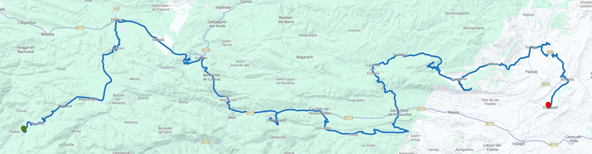
This tour, the southernmost of three routes through Cathar country, starts in Montaillou and ends in Tautavel.
Montaillou, with its castle ruins, is a village that became world famous almost thirty years ago and gave the Cathars a cult status. Thanks to the French historian Emmanuel Le Roy Ladurie who, with the help of files from the Inquisition, resurrected a heretical (read: Cathar) village in the Pyrenees 1294-1324. He describes the complete history of this village: life from the cradle to the grave, the concern to make ends meet, kinship and feud, decency and crime, magic and the search for salvation, folklore, myths and the realm of the shadows. All this against the background of the Inquisition, which at the beginning of the fourteenth century subjected the remote mountain village at the foot of the Pyrenees to a thorough investigation. Montaillou had no more than 250 inhabitants, mainly farmers and shepherds. Jaques Fournier, the ambitious bishop of Pamiers who later even rose to Pope Benedict XII in Avignon, led the investigation. No heretic was safe from this medieval Maigret, who made his victims tell more than they actually wanted to tell. He exposed all the village secrets, everything was noted down: the intimate life of the shepherd and freebooter Pierre Maury, the unbridled love life of the unscrupulous village priest, heretic and informer at the same time, the easily inflamed passion of the lady of the castle Béatrice de Planissoles.
The history of this distant past calls for a visit to the remains of the feudal castle where the spirit of the Cathars still haunts. The village used to be higher up on the slope and closer to the castle, of which the stumps of three walls still remain. Almost nothing has been preserved of that higher village, except for the foundations. But the Fontcanal, the most important water source of medieval Montaillou, still works. From the Fontcanal, which is close to the castle ruins, you have the best view of present-day Montaillou.
The next village on your route is Camurac. It is known as a winter sports resort with skiing possibilities in the winter months: Pyrénées Audoises. Via a winding road you drive to the village of Belcaire to refuel. From Espezel it goes north to the hamlet of Lescale.
A large part of the houses of Lescale were set on fire by the Germans on 9 August 1944 in retaliation for actions of the resistance movement Maquis de Picaussel against the 11th Panzer Division on 6 August 1944. The hamlet was then rebuilt. A memorial keeps the memory of this incident alive. Passing the church, it now goes to Puivert.
Puivert and its castle are another stop on the Chemin des Cathares. It is an oddity among the Cathar castles: with its beautiful symmetrical construction, it does not have the inaccessibility of the other fortresses. Access is fairly easy, no strenuous climbing here. The castle is now privately owned and quite popular with film directors. The first traces of Puivert appear around 1170. When the crusade against the Cathars broke out in 1209, Gailhard de Congost was the lord of the castle. His family has never hidden its sympathy for the Cathars. In 1209, the castle was taken by the troops of Simon de Montfort after a siege that lasted only three days. In later centuries, the castle came into the hands of the nobility, but after the French Revolution, Puivert was finally abandoned.
The access bridge and the portcullis in the massive gate tower are not authentic. The immense courtyard of 80 by 30 meters dates from the beginning of the 14th century. Remains of the old castle (from before the 13th century) can be found behind the massive keep. This "residential tower" of 15 by 15 meters is 32 meters high. Above the entrance gate you can see the coats of arms of Thomas de Bruyères and Isabelle de Melun (they married in 1310). In the very well preserved keep there are four floors with one room each. Especially the two upper floors are worth seeing. On the third level you will find the chapel (with a beautiful baptismal font) and on the highest level the famous "salle des musiciens" with eight sculptures of musicians with their musical instruments. Partly because of this hall, the legend has arisen that Puivert was an important rendezvous place for troubadours in the 12th century, that it was much more of a "court of love" than a military fortress. Another floor higher you are on the roof of the keep where you can enjoy a beautiful view over the Quercorb. You can see the village of Puivert with a lake and a small airport in a bowl-shaped valley.
At the old provincial town of Quillan with almost 4000 inhabitants and where the coffee is ready for you, you reach the upper reaches of the Aude valley. You now leave the foothills of the Pyrenees behind you for good and enter the Mediterranean atmosphere.
The castle, located on the eastern bank of the Aude, dates from the 12th century, belonged to the Archbishop of Narbonne and was built according to the military ideas of that time. The building has a surface of 30 meters square with protruding corner turrets, a keep and entrance gate and drawbridge. From the castle in Quillan, battles were fought against the Cathars. From here you have a good view of the city and the surrounding mountains. Below you are the old bridge over the Aude and the centrally located Place de la Repubique. Furthermore, in the old town with its many narrow streets you will also find the Église Notre Dame, built in the Romanesque style of the 12th century.
A few kilometres south of Quillan, you come across a barrier in the road; the 4 km long Pierre-Lys gorge, carved out by the Aude river, was an impassable natural barrier until 1820. At the very entrance to the gorge, a huge rock blocked the road and there were scrambling paths to get around it. In 1820, Father Félix Armand, parish priest of Saint-Martin-de-Lys, dug a passage with a pickaxe to follow the river, a very narrow path, almost hanging on the edge of the void. In tribute to Father Armand, the passage is still called “le Trou du Curé” today.
You make a small detour to the Château de Puilaurens. The castle was built in 1229 on the site where a fortified church probably stood before. A small village also grew up around it. In 1245 and 1246, a few Cathars sought refuge here during the crusades against this, according to the Roman Catholic Church, heretical faith. However, the castle was not besieged during these crusades and passed into the hands of the French state around 1250. They used the castle as a line of defense against Aragon, a former county in present-day Spain.
The Treaty of the Pyrenees in 1659 moved the border a bit further south, at the natural border of the Pyrenees. As a result, the castle lost its importance and gradually fell into disrepair. However, it was never plundered on a large scale, which is why much of the original castle still stands today.
You can visit the castle daily from the end of March to mid-November (for a fee). From the parking lot, you climb the last few dozen meters up towards the ancient walls. The last part winds upwards, giving you a good view of the castle's defense lines. When you enter the castle grounds, you will find the most intact parts on your left. On the right is a large plain, where in earlier times all kinds of (probably mainly wooden) buildings stood. On the far right you will find a passage where you have a wide view of the surroundings and can discover why the castle was built on this spot. You can keep a close eye on who is traveling through the area from all sides.
Caudiès-de-Fenouillèdes owes its name to the Roman Cauderiae, a Roman villa that once stood here. There may have been habitation there in prehistoric times. The name has been mentioned since 852 as a place at the upper reaches of the Vallée de la Boulzane. It is an old town with old entrance gates, a Place de la Mairie lined with shady plane trees and a few half-timbered houses. The facade of the town hall still features the old gable stone with the coat of arms of Caudiés, a copper cauldron, from before the Revolution. There is also a parish church from the 17th century.
In the immediate vicinity in Fenouillet lies the 11th century castle that belonged to the Vicomtes de Fenouillet and that played a strategic role for the narrow, damp and lushly vegetated Gorges de St. Jaume and the old connecting roads. After the Albigensian Crusade (1258) the situation changed and in 1595 it was set on fire on the orders of the Duc de Ventadour. What remains is the ruin of the castle of Fenouillet.
The next section goes through the narrow Galamus gorge. This is really impressive! The small river Agly has cut a deep gorge in the rocks here. A hundred meters above the river, which you can hear but usually not see, the narrow road sticks to the rock: bends, overhanging rocks and tunnels follow each other. At the bottom it is a series of waterfalls and small pools with crystal clear water. The Aigly squeezes through the Gorges de Galamus to the wide valley of the Fenouillèdes. You pass the Hermitage de St. Antoine, which is stuck to a ravine wall, a hermit's nest that reinforces the feeling of loneliness in a gorge where you seem to 'get' stuck as a rider. This hermit's house is located many meters above the rock-strewn bottom of the gorge, hidden under an overhanging rock. It is still an oasis of silence, high above the wild water of the Agly. The Hermitage dates back to the 7th century, but hermits lived there until 1950. A visit to the remarkable cave chapel and the upper cave that served as a residence for the hermits for centuries is worthwhile.
You follow the small river Agly upstream between the limestone ridges. The rock at the bottom of the gorge is covered with a yellow layer of limestone by the very calcareous water. The Chemin des Cathares runs through an uneven terrain of limestone formations, maquis, dense scrub that can grow high on the northern side of the slopes, and garrigues, a much more open landscape due to grazing and looks like a herb garden without fences. A fragrant mixture of herbs, plants and trees in a nature that seems pure until a blue glow disturbs the idyll: Bordeaux mixture or copper vitriol with slaked lime, one of the first chemical pesticides from the 19th century with which vines are sprayed against parasitic diseases. A greeting through the wine-growing region of the Corbières and Langeudoc.
You pass Bergerie de Bugamus and get a view of the imposing Château de Peyrepertuse. Peyrepertuse is one of the most beautiful Cathar castles in the area, situated on a narrow rock ridge, overlooking the Corbières. However impregnable these castles seemed, they were no match for the starvation tactics of the French king. Despite its size and location, the castle played hardly any role during the Albigensian Crusade. Guillaume de Peyrepertuse submitted to Simon de Montfort in 1217. The castle passed to the King of Aragon in 1226. In November 1240, Château de Peyrepertuse fell into the hands of the French after a siege of 3 days, because there was hardly any food in the castle. The castle had little to tolerate in the following centuries and fell into disrepair after the French Revolution.
From the imposing Château de Peyrepertuse you descend to the village of Duilhac, where spring water flows in large quantities from the rocks in the middle of the village. It has a Romanesque church from the 14th century. Then you drive on to Cucugnan. This beautiful wine village became "world famous" by the French writer Alphonse Daudet and his collection of stories "Lettres de mon moulin". One of those stories is called "Le curé de Cucugnan" and describes how Father Martin got the inhabitants of Cucugnan back into his church. In a thundering sermon he told how he visited heaven, purgatory and hell in a dream and... indeed, the entire population of Cucugnan was in hell! The sermon had such an impact that Cucugnan immediately became the most devout village in France.
You leave the wine village of Cucugnan, with its picturesque centre, in a south-easterly direction and immediately have the Château de Queribus, like almost all other Cathar castles that we have encountered along the way, prominently in view. The castle towers menacingly above the vineyards of the Hautes-Corbières and forms, as it were, an extension of a kilometre-long limestone ridge on which it is built. Via the northern ridge you reach the robust stronghold, which with its imposing keep was the last stronghold of the Cathars, which fell in 1255. In this keep is the famous "Gothic hall", where a round column supports a vault, which is formed by four arches that all have different dimensions: the column is not in the middle.
Little is known about the actual siege of Château de Queribus. There are no chronicles that mention it. There is some limited correspondence between the French king and his commanders on the spot, but it is largely undated and therefore difficult to place chronologically. The act of surrender is dated: May 1255. Chabert de Barbaira, who has apparently been captured, hands over the castle and all its appurtenances to the French king. No exhausting siege here and no burning at the stake: the Cathars had brought themselves to safety in time from the last "Cathar fortress" that remained. The military struggle against the Cathars and their protectors was thus over for good.
The location is strategically strong. From the castle at 728 metres altitude you have a magnificent view that extends from nearby Cucugnan to the plain of Roussillon, with the city of Perpignan in the middle and on the horizon in the east the blue Mediterranean Sea 34 kilometres away. Below you to the south, between two elongated limestone ridges, stretches the wide valley of Fenouillèdes with the Pic du Canigou (2724 m) in the distance 38 kilometres away.
From the Château de Quéribus you descend over the kilometres-long limestone ridge to the village of Padern, which lies like a small oasis in the dry land of the Corbières. Padern lies at the foot of the Montagne de Tauch, where the river Torgan flows together with the Verdouble. Here too, a ruined castle rises above the village that belonged to l'Abbaye de Lagrasse from the 9th century to 1579 and that was a battleground between Alain de Roucy, Seigneur de Termes, and l'Abbaye de Lagrasse during the Albigensian Crusade. Through the vineyards and below bare ridges you drive to Tuchan, one of the characteristic wine villages of the Corbières with a strong Mediterranean character. It is one of the nine villages where the Fitou wine comes from, but where the sweet dessert wine Muscat de Rivesaltes is also produced.
The village of Tuchan owes its name to the many yew trees (in Occitan dialect 'touch' means yews), which once covered Mont Tauch (917 m). Now there are only a few left. On this Mont Tauch stands the Tour des Géographes, built in 1791 by a group of astronomers. Plans are now being developed in this region to create a wind farm.
However, Tuchan is best known for the Château Aguilar, strategically situated on a hill overlooking the entrance to the Corbières. It is a short drive through the vineyards to the ruins of the castle. The castle has been mentioned since 1020 and was then in the possession of the Comte de Fonollède. In the second half of the 12th century it passed into the hands of the de Termes family. During the Albigensian Crusade in 1210 it was occupied by Simon de Montfort, who captured Raymond de Termes and had him killed in Carcassonne. Château Aguilar was a refuge for the Cathars for a short time, but played no significant military role during the crusade against the Cathars.
This is actually where this southern Cathar route ends. From here it is on to your final destination Tautavel where there are possibilities to stay with a snack and drink and even a bed.


 Links
Links  Usage
Usage Want to download this route?
You can download the route for free without MyRoute-app account. To do so, open the route and click 'save as'. Want to edit this route?
No problem, start by opening the route. Follow the tutorial and create your personal MyRoute-app account. After registration, your trial starts automatically.  Disclaimer
Use of this GPS route is at your own expense and risk. The route has been carefully composed and checked by a MyRoute-app accredited RouteXpert for use on TomTom, Garmin and MyRoute-app Navigation.
Changes may nevertheless have occurred due to changed circumstances, road diversions or seasonal closures. We therefore recommend checking each route before use.
Preferably use the route track in your navigation system. More information about the use of MyRoute-app can be found on the website under 'Community' or 'Academy'.

Occitanie
About this region
Occitanie (French pronunciation: [ɔksitani] (listen); Occitan: Occitània [utsiˈtanjɔ]; Catalan: Occitània [uksiˈtaniə]), Occitany or Occitania (), is the southernmost administrative region of metropolitan France excluding Corsica, created on 1 January 2016 from the former regions of Languedoc-Roussillon and Midi-Pyrénées. The Council of State approved Occitanie as the new name of the region on 28 September 2016, coming into effect on 30 September 2016.The modern administrative region is named after the larger cultural and historical region of Occitania, which corresponds with the southern third of France. The region Occitanie as it is today covers a territory similar to that ruled by the Counts of Toulouse in the 12th and 13th centuries. The banner of arms of the Counts of Toulouse, known colloquially as the Occitan cross, is used by the modern region and is also a popular cultural symbol. In 2015, Occitanie had a population of 5,839,867.
Read more on Wikipedia
View region
 Statistics
  73
73Amount of RX reviews (Occitanie)
 26003
26003Amount of visitors (Occitanie)
 3641
3641Amount of downloads (Occitanie)
 Route Collections in this region
 25 Magnificent trails in France
This MRA route collection contains 25 beautiful motorcycle routes in different parts of France, such as the Ardennes, the Alsace, Vercors, the Drôme, the Ardèche, Cote d'Azure, Gorges du Verdon, the Ariège, the Dordogne and Brittany.
The routes have been carefully created by Bert Loorbach, who is an enthusiastic motorcyclist himself. He lived in France for a year and a half, during which time he devoted himself to mapping the unknown and beautiful back roads of France especially for motorcyclists.
The routes are bundled in the Motortourgids France part 1 of Kosmos publishing house and now also available in MyRouteApp.
I have taken over the routes in MRA and sometimes adjusted them slightly to make them even more interesting for the motorcyclist.
View Route Collection
24 Magnificent trails in France
It is clear that France is one of the most beautiful and best touring countries. It offers an incredibly varied landscape with good roads and a pleasant climate. It is not for nothing that you see so many motorcyclists there. My previous collection of 25 routes in France (25 Magnificent routes in France) were based on the route descriptions from the Motortourgids France part 1 made by Bert Loorbach.
This collection of 24 routes comes from Motortourgids France part 2. In this collection, a difference has been made between approach routes and motorcycle tours in a certain area. The approach routes can also be used in combination with the routes from Motortourgids France part 1
The routes are sometimes slightly adjusted based on the tips that Bert Loorbach gives in his description, or because of another place to spend the night, or to reach the minimum length of 2 hours for the MRA Library. For each route, the review contains a more detailed description, including options to stay overnight or places of interest along the way, which are also indicated with a POI and if possible with a short description.
Two or more routes have been created for a number of areas, such as for Burgundy, Auvergne, The Alps, Tarn and Cévennes and Nord-Pas de Calais. These routes can be nicely combined in a multi-day trip.
View Route Collection