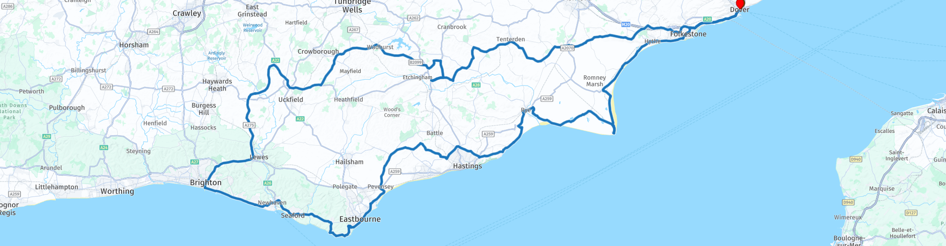
Round trip from Dover to Brighton

This route was brought to you by:
RouteXpert Nick Carthew - (MRA Master)
Last edit: 27-03-2025
 Route Summary
 You can choose a more leisurely pace and book a room from one of the many different types of accommodation to stay overnight in Brighton, or you can choose to complete this route in one (long) day.
Original route by: Roger Umans. I have adapted it so that it is equal for all navigation devices.
Beautiful English countryside and seascapes and an easy to ride route earn this route 3*** stars
 Share this route


Animation

Verdict


Duration
10h 28m

Mode of travel
Car or motorcycle

Distance
328.30 km

Countries

 RouteXpert Review
 The route soon heads out into the beautiful Kent countryside passing through small towns and villages as it makes it's way to East Sussex and then the seaside resort of Brighton.
There are several places to stop along the way:
Tenterden, known as the ‘Jewel of the Weald’, offers the best of all worlds; fascinating history, a wealth of architecture and excellent shopping - all within everyone’s idea of a typical country town and surrounded by Kent’s tranquil countryside. Stop for a coffee, there are several places to choose from.
Rolvenden Motor Museum, a great stop and only £5 entrance. The main feature is the unique collection of Morgan 3 wheel cars, 11 are normally on display, dating from 1909 to 1935. Other vehicles include: 1929 Ford 'A', 1929 Morris Van,1904 Humber tri-car, 1936 Bampton Caravan, along with motorcycles, bicycles, tricycles and displays of toy and model cars, surrounded with automobilia.
Then you'll pass Rolvenden Windmill, an historic post mill which bears a date of 1772, but is believed to be older, possibly the mill marked on the 1596 map. The mill last worked circa 1885, when two sails are known to have been removed. The original roundhouse was demolished during the First World War.
Bodiam Castle. Originally built in 1385, Bodiam Castle has spent centuries as one of the best loved and best known castles in England. Perhaps it is the design of the building, with an iconic moat and beautiful lush green scenery, or simply the amazing history of the building, which makes it so popular?
Then it's on to Brighton, the route passes the world famous Harry Ramsden fish and chip shop, situated conveniently close to Brighton Pier. This would make a nice lunch stop or the end of the first day if you plan to stay overnight.
The return route to Dover stays closer to the coast with historic and scenic viewpoints all the way.
Birling Gap is part of the world famous Seven Sisters chalk cliffs, one of the longest stretches of undeveloped coastline on the south coast. A short walk to an elevated tower above the beach allows you to take some great photos.
Beachy Head is a famous beauty spot on the south coast in East Sussex. The cliffs are the highest chalk sea cliffs in the UK – 162 metres above sea level – giving spectacular views. A short walk takes you to the top of the cliffs where you get a magnificent view and photos of Beachy Head Lighthouse.
Then there is an historical Napoleonic fortification known as The Eastbourne Redoubt, built in 1805 to help repel any attempts to invade the British Isles during the Napoleonic Wars. During the First World War the military police used the Redoubt as a headquarters and temporary jail. The army requisitioned the building in the Second World War to use for storage. In 1944, anti-aircraft guns were mounted on the gun platforms to counter passing V1 flying bombs. Canadian troops also spent time at the Redoubt in the build up to the D-Day landings. So as you can see, it has been repurposed many times and it can obviously tell many tales.
Perched on a hill, the medieval town of Rye is the sort of place you thought existed only in your imagination. Almost suspended in time, Rye’s unhurried atmosphere and enchanting streets draw visitors with a warm welcome. It’s small enough to make you feel at home almost straight away but holds enough secret treasures to entice you to stay much longer. It's the perfect place to wander around and have a coffee.
The route now crosses Romney Marsh and back into the county of Kent where you will experience Britain's only desert, classified by the Met Office, UK’s national weather service.
Dungeness is a world of contrasts. Some of it looks like a post apocalypse scene but the area has also been designated as a National Nature Reserve (NNR), Special Protection Area (SPA), a Special Area of Conservation and a Site of Specific Scientific Interest (SSSI). To add even more bizarreness, it has two nuclear power stations and two lighthouses, all built on what is one of the biggest shingle peninsulas in the world.
A succession of historic Napoleonic is next with 3 Martello Towers and another Redoubt at Dymchurch.
A chain of towers based on the original Mortella towers of Corsica were built to defend the south and east coast of England, to guard against possible invasion from France, then under the rule of Emperor Napoleon. A total of 103 Martello towers were built in England between 1804 - 1812.
Crossing the Royal Military Canal signals that you are close to the end of this route. Stretching for 28 miles from Hythe, Kent, to Cliff End in East Sussex, The Royal Military Canal was built between 1804 and 1809 as a defence against invasion by Napoleon – although its guard posts also proved useful in stopping the then-flourishing trade in smuggled goods.


 Links
Links  Usage
Usage Want to download this route?
You can download the route for free without MyRoute-app account. To do so, open the route and click 'save as'. Want to edit this route?
No problem, start by opening the route. Follow the tutorial and create your personal MyRoute-app account. After registration, your trial starts automatically.  Disclaimer
Use of this GPS route is at your own expense and risk. The route has been carefully composed and checked by a MyRoute-app accredited RouteXpert for use on TomTom, Garmin and MyRoute-app Navigation.
Changes may nevertheless have occurred due to changed circumstances, road diversions or seasonal closures. We therefore recommend checking each route before use.
Preferably use the route track in your navigation system. More information about the use of MyRoute-app can be found on the website under 'Community' or 'Academy'.