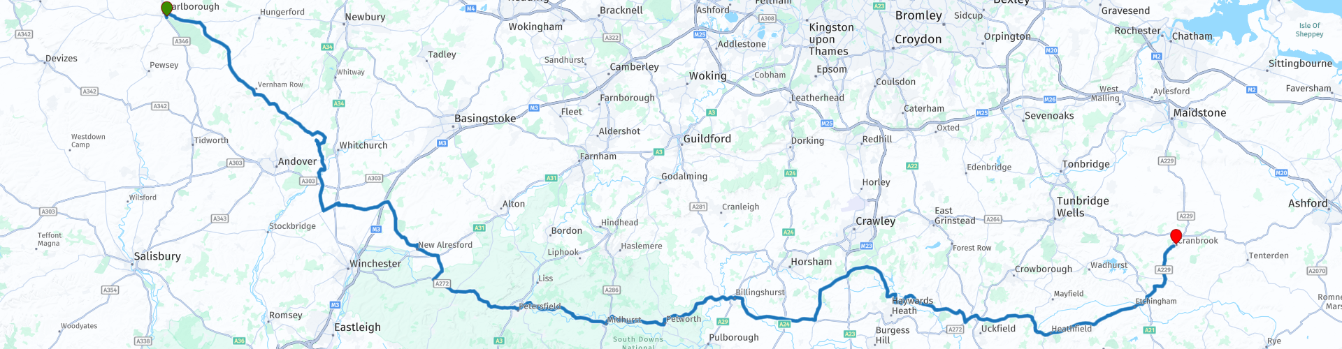
11 Marlborough to Cranbrook via South Downs National Park

This route was brought to you by:
RouteXpert Nick Carthew - (MRA Master)
Last edit: 14-11-2022
 Route Summary
 This route is all about journey and what a journey it is! You'll be travelling through the beautiful English countryside, including two Areas of Outstanding Natural Beauty (AONB) and a national park. You will notice not only the changing landscapes, but the changes in the local architecture, most notably in the materials used. A good mixture of roads and the beautiful scenery earn this route 4**** stars.
 Share this route


Animation

Verdict


Duration
7h 8m

Mode of travel
Car or motorcycle

Distance
233.26 km

Countries

 RouteXpert Review
 Just two miles from the start you'll have the option of leaving the route and riding through Savernake Forest on a well maintained gravel road for approximately 3 miles. The forest is a Special Site of Scientific Interest (SSSI) as well as a registered important historic park, making it the perfect forest for an exciting start to a days ride. If you decide not to ride the gravel road, the A4 still cuts through the forest on it's way to cross over the Kennet and Avon Canal at Great Bedwyn.
The Kennet and Avon is an impressive feat of engineering, made up of two river navigations and a linking stretch of canal. It runs from the Severn Estuary near Bristol to the River Thames at Reading, over 100 miles long with more than 100 locks, some magnificent engineering and crossing some of the most beautiful scenery in southern England. It was reopened in 1990 after decades of dereliction and has been returned to it's former glory.
The Wiltshire village of Great Bedwyn is an idyllic and historic settlement in a lovely landscape. Thatched cottages with well kept gardens line the road as you pass through. You'll notice that the use of flint as a building material on the older properties.
Hurstbourne Tarrant is a village a few miles south of Great Bedwyn and lying across the county border into Hampshire, here you'll also find flint built cottages with thatch used for roofing material but this village also has a wartime tale to tell.
During World War II, Hurstbourne Tarrant played its part, mainly by hosting a decoy to deflect bombs from the important RAF airfield at Andover. A series of lights simulated an active airfield along with fake aircraft and buildings. From September 1940 fake machine gun posts were added and the site is recorded as being active until 1942. Sadly none of these features remain because the site has been returned to agricultural land.
You'll pass watercress farms on the way to the Test Valley, most famous for its fly fishing and the clear chalk streams of the River Test and its tributaries yield up brown trout, grayling and salmon. While I'm talking about famous, you'll pass by Longparish House where the ex F1 racing driver Jonathan Palmer lives. The17c country house built in the style of a French Chateau. It was occupied by the Bank of England during WWII as London was deemed too unsafe.
Micheldever is another village with a story to tell.
Micheldever Station was the starting point for the first automobile journey in Britain, in 1895. The vehicle, a Daimler-engined Panhard-Levassor, had been ordered from France by the Hon Evelyn Ellis (1843–1913). It was transported across the channel by ferry and then to Micheldever Station by train. Ellis received delivery on the platform and drove the vehicle to Datchet, deliberately testing an Act of Parliament that required all self-propelled vehicles on public roads to travel at no more than 4 mph and to be preceded by a man waving a red flag. Ellis was not arrested and the Act was repealed in 1896. Thank you Evelyn Ellis ;)
Travelling through more beautiful countryside you'll soon enter the South Downs National Park.
The South Downs National Park is England's newest national park, designated on 31 March 2010. The park's chalk downland sets it apart from other national parks in Britain. The chalk was formed between 100 million and 66 million years ago, when the area was under the sea. However, luckily for us, the same tectonic movements that created the Alps, uplifted the land that we see here today.
A short distance after entering the park, you'll take a right turn by a BP fuel station and 100m on from here you'll find Loomies Moto Café, a Café run by bikers for bikers. It's a great place to stop for a coffee and chat with like minded people.
The A272 takes you through the heart of the national park crossing the county border into West Sussex where you'll notice the use of Malmstone as a building material for some of the historic buildings. Even though the A272 is classified as an 'A road, it still a delightful road to use as it travels through the rural countryside of Hampshire and West Sussex for 44 miles.
At Midhurst, you have the opportunity of visiting or just viewing the ruins of Cowdray Castle.
The Cowdray Heritage Ruins are one of England’s most important early Tudor houses and Cowdray is known to have been visited by both King Henry VIII and Queen Elizabeth I. In September 1793, whilst undergoing repairs and refurbishments for the impending marriage of the 8th Viscount Montague, a devastating fire took hold and most of the property was destroyed. The Kitchen Tower is the only part of the mansion to remain intact.
Petworth is just a few miles further along the A272. The town is mentioned in the Domesday Book of 1086 as having 44 households (24 villagers, 11 smallholders and nine slaves) with woodland and land for ploughing and pigs and 24 acres of meadows.
Today, Petworth is a little larger and is the location of Petworth House, a late 17th-century Grade I listed country house, the grounds of which (known as Petworth Park) were the work of Capability Brown (English gardener and landscape architect). Petworth House is set in a 700-acre deer park and displays one of the finest art collections in the care of the National Trust. To visit Petworth House and Park, follow the signs.
The A272 that runs east/west meets the A29 that runs north/south at a village called Billingshurst, so consequently the village is known as a crossroad village. Unsurprisingly Billingshurst derived much of its trade in years gone by from coaching traffic on its way to and from London. It’s always been a place for passing through but the centre of Billingshurst really is charming, there are more shops than a village of its size has any right to expect.
3 miles from Billingshurst is the small village of Coolham where I suggest the Selsey Arms as a lunch stop.
During the Second World War there was an Advanced Landing Ground nearby called RAF Coolham, used to support the D-Day landings. This was only in use for about eighteen months, and had almost no permanent buildings. The airmen lived under canvas. Both Polish and British airmen were stationed there, and there is a monument outside the Selsey Arms that lists the names of those who died. The land has long since been reclaimed for agricultural purposes, but there is still a footpath around the field, with trees planted at intervals to commemorate the dead airmen. Each tree has a name plaque attached. Kenny's Spitfire is a life size replica of a Vickers Supermarine Spitfire MK IX. It was built during lockdown 2020 by the landlord of the Selsey Arms pub, Kenny Easton to showcase the historical importance of Coolham and its airfield. Lots more information can be found inside the pub.
After lunch, you’ll leave the A272 at Cowfold and head into the area known as The High Weald, an Area of Outstanding Natural Beauty (AONB). Defined as a medieval landscape of wooded, rolling hills studded with sandstone outcrops; small, irregular-shaped fields; scattered farmsteads; and ancient route-ways. The area covers parts of West Sussex, East Sussex and Kent at the heart of South East England.
The Ouse Valley Viaduct is a fantastic feat of civil engineering and is truly a structural marvel. It is estimated that around 11 million bricks were used to build this masterpiece in 1838 carry the mainline trains from London – Brighton. The viaduct is 96 feet (29 m) high and is carried on 37 semi-circular arches spanning a total length of 1,480 feet (450 m). There is a short public footpath that will take you to the base of the viaduct where you can climb up into one of the arches for a really cool perspective photo.
Another railway nearby is the Bluebell Railway, you’ll pass under one of it’s bridges at Cockhaise Mill. The Bluebell Railway was the first preserved standard gauge steam-operated passenger railway in the world to operate a public service, resulting in one of the finest collections of vintage steam locomotives and carriages. The 11 miles of track run from Sheffield Park to East Grinstead and became known as the Bluebell Railway because of the abundance of bluebells along the line. If you’re VERY lucky, you may see one of the steam locomotives as you pass under the bridge.
For a close up view of the steam locomotives, Sheffield Park Station is just a small detour from the route.
Another county border crossing into East Sussex and a chance to stop for a coffee at Costa Coffee on the outskirts of Maresfield.
Maresfield was once a large country estate, effectively in the ownership and control of the family in the now demolished Maresfield Park House, initially the Shelley family and then Count Alexander Münster of Hanover, Germany. The estate was confiscated in 1914 by the government after the start of World War 1. The main house was demolished and the park and estate houses were sold off in 1924 as reparation for war damage, the park being broken up into housing plots.
The next 21 miles to the final county border crossing into Kent travels on more delightful roads through more beautiful English countryside.
The county of Kent is known as The Garden of England because of the gentle rolling hills and fertile soil. This allows for great growing conditions for fruit trees such as apples, pears and plumbs and nut trees like hazelnut, sweet chestnut and walnut. Another major crop was the hop, used in the process of brewing beer. The fertile soil and mild climate in Kent, along with the practice of farming enclosed fields rather than open fields, and a good supply of sweet chestnut coppice for the poles and charcoal, meant that by the mid-17th century the county was responsible for producing a third of the national crop. This makes Kent not only The Garden of England but also The Beer Garden of England where some of the finest ales and wines can be found.
You may spot an oast house along the way.
An oast, oast house or hop kiln is a building designed for kilning (drying) hops as part of the brewing process. They consist of a rectangular one- or two-storey building (the "stowage") and one or more kilns (often round in shape) in which the hops were spread out to be dried by hot air rising from a wood or charcoal fire below. The drying floors were thin and perforated to permit the heat to pass through and escape through a cowl in the roof which turned with the wind. These are iconic buildings in the landscape of Kent as is the use of Ragstone and white painted weather-boarding on the more historic rural cottages. You’ll see this when you pass through the your first Kent village of Hawkhurst.
Hawkhurst is really two villages in one – the tranquil settlement in the oldest part known as The Moor, the first part you’ll see and a pretty shopping area at Highgate, a few hundred metres on. The name of Hawkhurst was once notorious throughout southern England as the home of the Hawkhurst Gang of smugglers active in the early 1700s.
They were the most notorious of the Kent gangs, and were feared all along the south coast of England. At Poole in Dorset, where they had launched an armed attack on the customs house (to take back a consignment of tea that had been confiscated), several were hanged. Hawkhurst is a lot calmer today!
The end of the route in the small town of Cranbrook is just 4 miles away.
Cranbrook, known as the Capital of the Weald, is a pretty town with a medieval layout of streets and alleys – many buildings dating from the 15th century through to the 19th century. Once the bustling centre for the region’s medieval cloth weaving industry, Cranbrook today is still a bustling market town full of interesting shops. The newly restored Union Mill, Cranbrook’s most famous landmark, is one of the finest smock mills in the UK and still dominates the skyline. St Dunstan’s Church, known locally as the ‘Cathedral of the Weald’, Cranbrook Museum with its fascinating collections of local history, and the George Hotel where Elizabeth I is reputed to have visited in 1573, are all fine examples of the many splendid old buildings in the town.
I have suggested the George Hotel for your overnight accommodation.
Enjoy.
Footnote:
There is one more route remaining in this road trip that will take you on a short tour around Kent. If you wanted to shorten this road trip, Dover is just 45 miles (1 hour) from Cranbrook.


 Links
Links  Usage
Usage Want to download this route?
You can download the route for free without MyRoute-app account. To do so, open the route and click 'save as'. Want to edit this route?
No problem, start by opening the route. Follow the tutorial and create your personal MyRoute-app account. After registration, your trial starts automatically.  Disclaimer
Use of this GPS route is at your own expense and risk. The route has been carefully composed and checked by a MyRoute-app accredited RouteXpert for use on TomTom, Garmin and MyRoute-app Navigation.
Changes may nevertheless have occurred due to changed circumstances, road diversions or seasonal closures. We therefore recommend checking each route before use.
Preferably use the route track in your navigation system. More information about the use of MyRoute-app can be found on the website under 'Community' or 'Academy'.

South East
About this region
The points of the compass are an evenly spaced set of horizontal directions (or azimuths) used in navigation and geography. A compass rose is primarily composed of four cardinal directions—north, east, south, and west—each separated by 90 degrees, and secondarily divided by four ordinal (intercardinal) directions—northeast, southeast, southwest, and northwest—each located halfway between two cardinal directions. Some disciplines such as meteorology and navigation further divide the compass with additional azimuths. Within European tradition, a fully defined compass has 32 'points' (and any finer subdivisions are described in fractions of points).Compass points are valuable in that they allow a user to refer to a specific azimuth in a colloquial fashion, without having to compute or remember degrees.
Read more on Wikipedia
View region
 Statistics
  21
21Amount of RX reviews (South East)
 19525
19525Amount of visitors (South East)
 1812
1812Amount of downloads (South East)
 Route Collections in this region
 8 beautiful routes through England
"8 beautiful routes through England"
You may have seen one of these routes pass by. Eight routes have been driven and made in 2018.The routes are part of a 9-day trip through England. You drive through landscapes that are varied and beautiful. You can see beautiful rolling hilly vistas.
The main roads are of reasonable to good quality, but you also drive on roads that are less maintained and there may be some gravel on the roads here and there.
In general, they are beautiful routes through a beautiful country. The routes are connecting and turn left around London. The start and end points of the routes are Hull.
The collection contains the following routes;
Day 1 from Hull to Ashbourne (224 km)
Day 2 from Ashbourne to Birdlip (245 km)
Day 3 from Birdlip to Feldbridge (295 km)
Day 4 from Feldbridge to Whitstable (250 km)
Day 5 from Whitstable to Colchester (227 km)
Day 6 from Colchester to Hinckley (233 km)
Day 7 Tour and visit Triumph Factory and National Motorcycle Museum (77 km)
Day 8 from Hinckley to Hull (262 km)
All routes have been checked and leveled for Tomtom, Garmin and MyRoute-App Navigation. The routes follow the original route as they were made at the time.
Have fun driving one of these routes. Enjoy all the beauty that England has to offer, such as; The Clumberpark, Bolsover Castle, The Seven Sisters, The White Ciffs of Dover. Of course, a visit to the Triuph factory and the National Motorcycle Museum is also highly recommended.
View Route Collection
A collection of routes covering East England including Hull Scarborough Newmarket Colchester Orpington and Folkestone
East England has a host of great roads to travel and many historical sites to visit.
The picture above shows the North York Moors National Park in all of it's glory with the heather in full bloom. This collection of routes covers as far north as Lindisfarne and as far south as Folkestone, they all travel through varied landscapes from high moorland to the level fens and everything in between. There is something for everyone in this collection. There is also a mini 2 day tour down the east coast from Hull to the Eurotunnel for those that want to enjoy the journey south before heading into Europe, this of course can be joined from anywhere along the way.
As with all MyRoute-app RouteXpert routes, these have been made equal for MRA Navigation, TomTom and Garmin devices meaning that whatever GPS satnav you use, you and all of your travelling companions are guaranteed to follow these routes precisely. Enjoy.
View Route Collection