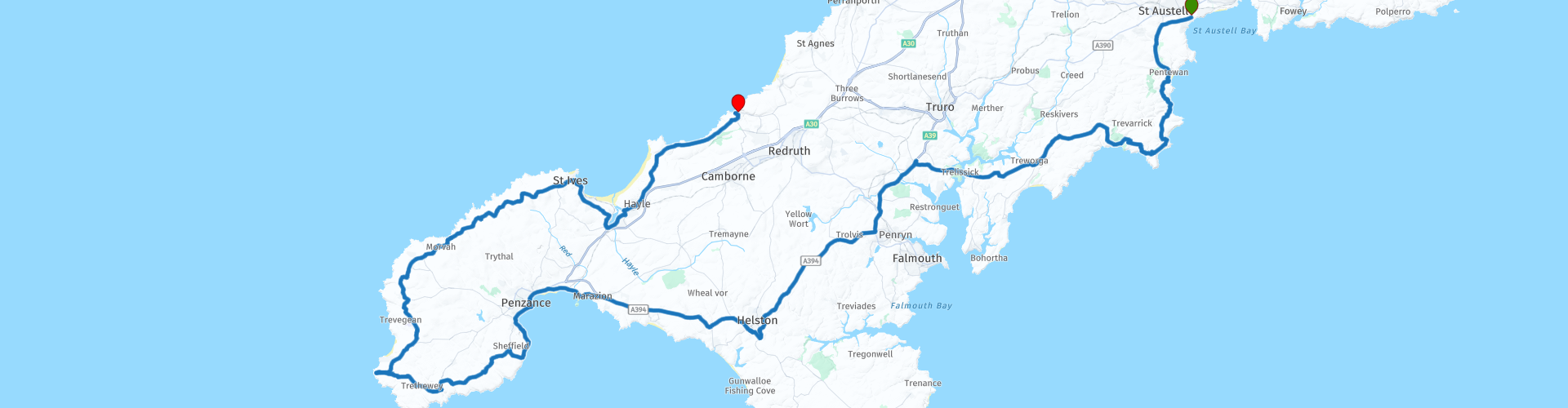
07 Charlestown to Portreath via Lands End

This route was brought to you by:
RouteXpert Nick Carthew - (MRA Master)
Last edit: 12-10-2022
 Route Summary
 This route visits fishing villages and uses the King Harry Ferry to cross the Carrick Roads reach of the estuary of the River Fal at a cost of £2 for a motorcycle. It then visits other coastal towns and villages including the famous tourist hotspot Land's End. The landscapes, attractions are excellant and roads are very good earning this route 5***** stars
 Share this route


Animation

Verdict


Duration
7h 19m

Mode of travel
Car or motorcycle

Distance
165.53 km

Countries

 RouteXpert Review
 Just 6 miles from the start of the route at Charlestown is the fishing village of Mevagissey, once the centre of Cornwall’s pilchard fishery and which still boasts a working harbour, with a few dozen small fishing boats. It has a tradition of boat building dating back to 1745. Many of the old buildings, constructed of cob and slate, bear testimony to a time when the large shoals of pilchards were the livelihood of the whole village. The route takes you to the harbour edge, so park up and have a look around this historic village.
Just a mile away along the coastal road is the village of Portmellon that has a long history of building boats with many wooden–hulled boats leaving the workshop over the years. At low tide rock pools are exposed and on some occasions seals can be seen swimming off the beach or resting on the rocks.
The next village is Gorran Haven, an ancient fishing harbour. The first record of “seining” in Cornwall, the catching of pilchards with long nets, occurs in relation to the village in the 13th century. At this time Gorran Haven was a more important fishing centre than Mevagissey! The first pier was built way back in the 15th century. In the 18th and 19th centuries it became a port handling merchandise brought from Fowey by barges and lighters. The pier was rebuilt in the 1820s and reconstructed again in 1886, believed to be the sixth time. The village became important in the catching of crabs and lobsters and this continued until the Second World War but after that commercial fishing declined rapidly. The Gwineas rock can be seen just over a mile away. This has acted as a magnet for many a shipwreck in the days before warning buoys and is a resting place for seals and sea birds!
Leaving Gorran on a steep, narrow lane, you'll come to a gate leading you to maybe the best unhindered coastal views in Cornwall. The single track road of Lamledra Hill takes you across open grassland and offers you a fantastic view of Dodman Point, the highest headland on the South Cornwall coast at 114m. Not surprisingly, in view of its tremendously strategic location, throughout history Dodman Point has been an important site to the local inhabitants. Prehistoric remains here include Bronze Age barrows and the massive Iron Age fortifications, as well as medieval field systems and a much later Napoleonic signal station. There have been countless wrecks at the feet of the Dodman. One of the worst incidents occurred in December 1830 when three foreign vessels (Danish, French and Russian) were all wrecked close to the headland in one night. Another tragedy happened in 1838 when the brig Brandywine Packet was lost in a gale, all the crew were drowned apart from one man, James Gilchrist, who somehow managed to cling to rocks until help arrived. A huge 6m tall granite cross was erected at the tip of the peninsular in 1896 to commemorate the poor souls that perished below.
Coffee stop at Caerhays Beach Cafe with lovely views of Porthluney beach and Caerhays Castle is next before heading to the King Harry Ferry.
The chain operated ferry crossing the River Fal has been voted one of the ten most scenic ferry trips in the world by The Independent, alongside the Staten Island Ferry in New York and the Star Ferry in Hong Kong.
On the opposite bank is Trelissick House and Garden, positioned in one of the most spectacular locations with stunning views looking over the Fal River and towards Falmouth. The house dates back to the 1750s and is now open to the public. You may think that you have landed in another country as you pass the magnificent Rapunzel-esque water tower that once served the estate, now it’s a very romantic B&B.
The route uses faster roads now to take you to the far SW of England and the tip of Cornwall.
First to see is Saint Michel's Mount.
Historically, St Michael's Mount was a Cornish counterpart of Mont-Saint-Michel in Normandy, France, with which it shares the same tidal island characteristics and a similar conical shape, though Mont-Saint-Michel is much taller. From as far back as 495AD, tales tell of seafarers lured by mermaids onto the rocks, or guided to safety by an apparition of St Michael. The patron saint of fishermen, it’s said the Archangel Michael appeared on the western side of the island – below where the entrance to the castle is today – to ward fishermen from certain peril. It’s a legend which has brought pilgrims, monks and people of faith to the island ever since, to pray, to praise and to celebrate.
Passing through the two large harbour towns of Penzance and Newlyn, the route takes you to Mousehole.
Popular for retaining its original character, charm and beauty, Mousehole is a tiny fishing village. Its picturesque harbour is surrounded by narrow streets and yellow lichened houses, which huddle together creating a stunning location. Along the harbour road you’ll find galleries, gift shops and restaurants making this location an ideal place to stop for some lunch, I recommend The Ship Inn overlooking the harbour.
After lunch, you head for the iconic landmark of Land's End.
Land’s End is one of Britain’s best loved landmarks, famous for its unique location, natural beauty and stunning scenery. Throughout the ages, Land’s End has held a fascination for many people and the place has inspired many stories and works of art. The mythical ‘Lost Land of Lyonesse’ is said to lie beneath the waves between Land’s End and the Isles of Scilly. According to legend, Lyonesse was a rich part of King Arthur’s realm that was drowned by the sea on a cataclysmically stormy night. There are over 130 recorded shipwrecks around Land’s End, as well as countless more unrecorded. In modern times, Longships Lighthouse at Land’s End forms one point of an important protective triangle – Longships Lighthouse, Wolf Rock Lighthouse and the Lizard Lighthouse collectively create one of the most well lit waterways in the British Isles.
Land’s End is also the most westerly point of not only this route, but the whole road trip from Dover, 318 miles or 511 kms as the crow flies from Dover. Ride your motorcycle to the left and around the back of the Land’s End entrance building and park next to the hotel for some great photos.
Cornwall is famous for the mining industry especially tin and the Land’s End Peninsular is dotted with the ghostly buildings of its historic past. Engine houses, the tall buildings with a large chimney are the surviving relics from a once prosperous industry. You can visit a more modern tin mine at Geevor, the last mine to work the famous St Just Mining District, the site of the largest number of undersea tin and copper mines in the world! Geevor consisted of more than 100 miles of tunnels that stretched a mile underneath the sea. Since its closure in 1990 the tin mine has operated as a museum and education centre for Cornish mining, keeping this vital part of history alive.
The route travels past an old engine house where you can stop and take a closer look. Carn Galver Engine House is a classic example of a Cornish engine, a type of steam engine developed in Cornwall, mainly for pumping water from a mine. It is a form of beam engine that uses steam at a higher pressure than the earlier engines designed by James Watt. The engines were also used for powering man engines to assist the underground miners' journeys to and from their working levels, for winching materials into and out of the mine, and for powering on-site ore stamping machinery.
Now the route travels to St Ives where you can take a little detour to visit this very popular seaside location.
Winner of a showcase of national awards including best family holiday destination by Coast magazine and one of the 10 best European beach destinations compiled by TripAdvisor, St Ives is a seemingly subtropical oasis where the beaches are golden, the vegetation is lush and the light piercingly bright. It’s no wonder then that the town has been attracting artists for decades who come to capture the area’s undeniable natural beauty. It started with J M W Turner and the marine artist Henry Moore who first came to St Ives in the mid-1800s and since then the town has become a magnet for some of the world’s greatest painters, sculptors and ceramists. There is free motorcycle parking on Smeatons Pier, in my mind, there is no better place to enjoy an ice cream.
From St Ives, it is just a short 30 minute ride to the end of the route at Portreath.
Portreath's history is primarily from the 18th century when it was an important port for the shipping of copper ore from the mines of the Camborne - Redruth area. In its heyday in the 19th century, over 100,000 tons of copper ore passed through Portreath bound for destinations around the world. Until the mid 1700s, the ore was loaded onto ships from the beach and it was only after the building of the quay by Francis Basset that the port had the luxury of being able to load the ships in a safer fashion. Today, the long sandy beach is the first port of call for most visitors to Portreath, especially surfers who want to experience ‘The Vortex’, a surf break that peels off the harbour wall. A stream trickles down the middle of the beach and out to sea and is a unique feature amongst the neighbouring beaches. I have suggested staying overnight at The Portreath Arms, a family owned and run bar, restaurant and 7 bedroom accommodation located in the centre of the village just a short walk away from Portreath’s harbour and beach.
Enjoy.


 Links
Links  Usage
Usage Want to download this route?
You can download the route for free without MyRoute-app account. To do so, open the route and click 'save as'. Want to edit this route?
No problem, start by opening the route. Follow the tutorial and create your personal MyRoute-app account. After registration, your trial starts automatically.  Disclaimer
Use of this GPS route is at your own expense and risk. The route has been carefully composed and checked by a MyRoute-app accredited RouteXpert for use on TomTom, Garmin and MyRoute-app Navigation.
Changes may nevertheless have occurred due to changed circumstances, road diversions or seasonal closures. We therefore recommend checking each route before use.
Preferably use the route track in your navigation system. More information about the use of MyRoute-app can be found on the website under 'Community' or 'Academy'.

South West
About this region
The points of the compass are an evenly spaced set of horizontal directions (or azimuths) used in navigation and geography. A compass rose is primarily composed of four cardinal directions—north, east, south, and west—each separated by 90 degrees, and secondarily divided by four ordinal (intercardinal) directions—northeast, southeast, southwest, and northwest—each located halfway between two cardinal directions. Some disciplines such as meteorology and navigation further divide the compass with additional azimuths. Within European tradition, a fully defined compass has 32 'points' (and any finer subdivisions are described in fractions of points).Compass points are valuable in that they allow a user to refer to a specific azimuth in a colloquial fashion, without having to compute or remember degrees.
Read more on Wikipedia
View region
 Statistics
  42
42Amount of RX reviews (South West)
 24429
24429Amount of visitors (South West)
 3706
3706Amount of downloads (South West)
 Route Collections in this region
 Great 6 day tour of Wales
This collection of 6 routes all pass through at least 1 of the 3 spectacular national parks of Wales'. Each park is unique and individual and the landscapes vary from the vast, remote and wide open moorland of the Brecon Beacons to the rugged mountains and glistening lakes of Snowdonia and the spectacular coastline of the Pembrokeshire coast. Each is a delight to travel through and these routes will take you to some of the best beauty spots.
There are some great attractions to visit too, as well as having more than it's fair share of fantastic castles and historic buildings, there is the worlds fastest zip line, a balcony road used for world rally stages, mysterious caves and magical waterfalls and a museum of land speed records. All of these can be seen on the routes in this collection.
Although each route in this collection is a separate stand alone route, they will all link up seamlessly to make a 6 day tour that you will remember. The tour starts and ends in Gloucester which can be easily reached in a day from any of the Channel ports.
Enjoy Wales.
View Route Collection
Top 10 Downloaded UK routes by RouteXpert Nick Carthew
Hello and welcome to this collection of the Top 10 MyRoute app downloaded routes in the UK.
There will be a great new event to be announced soon, where all these routes can be ridden.
Download them all now and place them in a new "Top 10" folder, so that you always have them at hand.
If you are going to drive one of these routes in the meantime, track them with the MRA Mobile App or with MRA Navigation. Take some photos (moments) along the way as these will come in handy.
Create a travelstory of your Top 10 driven routes and add the recorded track to it.
There will also be some great prizes on offer, so keep an eye on the MRA-RouteXperts page and your email.
View Route Collection