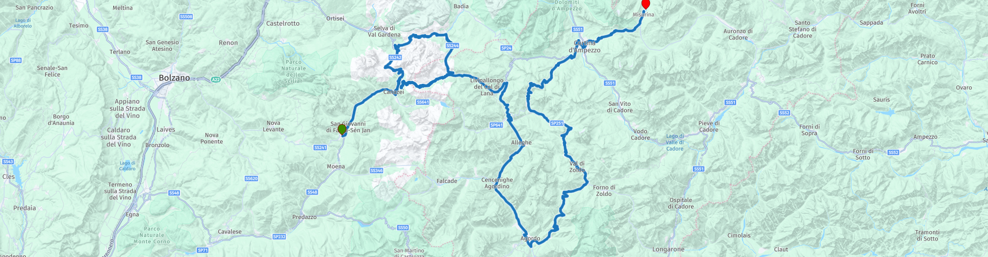
5 Vigo di Fassa to Misurina over the Passo Sela Passo Pordoi and Cortina d Ampezzo

This route was brought to you by:
RouteXpert Guy Heyns - Adv. RouteXpert
Last edit: 10-12-2024
 Route Summary
 Passo di Campolongo, Passo Pordoi, Passo Duran, Passo Staulanza,
Passo di Giau, Passo de Tre Croci and finally Passo di Misurina.
What is particularly wonderful is that you literally from very close to round the Sella massif and that you make a wonderfully large bend around the Marmelada, that other massif of the Dolomites.
It is also a very winding route in which you are optionally offered various opportunities to shorten or extend the route - according to your own wishes.
You can choose to arrive early in Misurina or to take one of the many (chair) lifts to some mountain top somewhere along the route.
You are of course free to choose.
You can therefore choose to adapt the route to your wishes and do relatively few or fewer kilometers.
In any case, whatever choice you make, this route will leave lasting memories because of its beauty and impressive views of the massifs of the almighty Dolomites.
This route consists almost entirely of 'green' Michelin roads, including the proposed shortening. So prepare yourself for a trip in which it will be 100% enjoyable ...
 Share this route


Animation

Verdict


Duration
5h 34m

Mode of travel
Car or motorcycle

Distance
211.56 km

Countries

 RouteXpert Review
 There is also something bad about this route; we are going to give you choice stress ..; are you going to use the foreshortenings or are you going to keep stringing the bends together? Are you indeed going for an 'easy' day or for a further reduction of the pubic area on your tires? In this route we propose a few choices. Fortunately for you, we also include our own advice on whether or not to go through them.
We start in Vigo di Fassa and soon, after barely 24 kilometers, you reach the Passo Sela which continues to give you an impressive view of the Sasso Longo of the Dolomites. Still swallow and realize how small you are on the worldly plane. Majestic, no other words for it. And then you have not yet looked to the right where the Sella massif unfolds before your eyes.
Enjoy while 7 kilometers later you drive up the Sela de Culac which takes you to the equally easy Passo Gardena around the foot of the Sella massif. Instead of already licking your thumbs and fingers, it is best to keep your hands on the handlebars for a while; the descent of the Gardena is super nice, but winding, so pay attention there.
Upon arrival in Corvara turn right towards Campolongo and Arabba. And there is the first choice: will you continue with the Pordoi or not? Our advice, yes, take those 30 kilometers of pure fun there and back. Unless it is super busy there (and there is a chance…), because if you constantly have to queue up, the fun is over very quickly.
In that case you can consider skipping rp 9 and not taking the shortening to Cortina d'Ampezzo at rp 10. If you want to enjoy a low traffic Dolomite ride, the southern dive of this route is highly recommended. It is much quieter than on the so-called 'Dolomite road' from Canazei to Cortina and in terms of pleasant curves, the Passo di Giau (rp17) is certainly not inferior to the rest.
If you don't want to make the long bend around the Civetta (one of the highest Dolomites mountains), feel free to take the shortening that we recommend on rp11. Also very beautiful and you save time, while you do not lose driving pleasure. We only give you a few options.
On rp 19 you will pass Cortina d'Ampezzo, the largest town in the Dolomites. Nice city, absolutely, but beware of the tourist traps that can quickly give you a bit of a wallet if you're not paying attention.
Another, nevertheless advisable, alternative for today is to use one of the many chair lifts or mountain trams that are frequently present along the route. They will take you to one of the peaks while you can look around completely free at the great massifs of the Dolomites.
There is also one on the Lago di Misurina that you can easily reach on foot once you have arrived at the hotel. You can use this to visit the Col di Varda, but - if you prefer this, also at rp 20 you can take two consecutive lifts towards Monte Cristallo with which you go 1000 meters higher. As I said in the beginning… choice stress….
My personal preference is to go through the Passo Pordio and take the shortening on rp 11, after which you make the climb to Monte Cristallo with the Rio Gere / Son Forca chair lift. Please note that the elevator closes at 5 PM. Keep in mind that (without queuing) you will need to spend an hour there and back. The consecutive rides take 6.5 and 7 minutes respectively, + a bit of looking around at the top. But certainly worth it, if you want to leave the mopeds downstairs for a while. Otherwise you park safely at the hotel, change your clothes and take a taxi to rp 20 for the 9 kilometers back.
Finally, a pleasant word about the Misurina lake. The legend about this is nice to know. Sorapiss (the mountain south of the route), used to be a god who, as a single parent, had to raise his daughter Misurina. Due to the lack of motherly care, Misurina became an annoying spoiled brat that had to be served at her beck and call. When Misurina heard that there was an elf living on the Cristallo (north of the route) who had a magic mirror with which you could read someone's mind, Misurina had to and would have it. Sorapiss pulled up to the elf who tacked on the condition that Sorapiss turned into a mountain so that he could shade the elf's flower garden. So it happened.
Misurina was given the mirror and watched her father turn into Mount Sorapiss to meet the elf's demand. She liked it too, because then she had a mountain to play on. So she walked up the mountain (her father) as it turned into an ever higher mountain.
She suddenly became dizzy from the great height and together with the mirror she fell to death into the great deep. Her father - transforming - could do nothing but look on weeping and his tears formed the Lago di Misurina. The multicolored sparkles in the water of the lake are - even today - caused by the mirror broken into thousands of pieces… ..
The route is uniquely worthy of a five star rating. There is hardly any transition, the highlights are reached quickly and smoothly and you can also do something other than motorcycling if you wish.
You can make it a chill day, even if you want to complete the route in its entirety. The only thing that can put a damper on the day is the crowds on the Dolomite road from Canazei to Cortina d'Ampezzo. Every tourist drives on this road.
That is why the loop around the Civetta has been added to the route, should the crowds at the top be disappointing.
Moreover, the route runs almost entirely on green Michelin roads. That should already be enough to be convinced of the quality of this route. We deliberately noticed few pause points, with the exception of the turning point on rp 9. You have many options on this busy route. We suggest that you stop where you feel like it and where there is room on the terraces.
Enjoy to the fullest and empty the container under your mouth in time on this sublime route. You often drive with your mouth open and you may not want it all dripping onto your discs….


 Links
Links  Usage
Usage Want to download this route?
You can download the route for free without MyRoute-app account. To do so, open the route and click 'save as'. Want to edit this route?
No problem, start by opening the route. Follow the tutorial and create your personal MyRoute-app account. After registration, your trial starts automatically.  Disclaimer
Use of this GPS route is at your own expense and risk. The route has been carefully composed and checked by a MyRoute-app accredited RouteXpert for use on TomTom, Garmin and MyRoute-app Navigation.
Changes may nevertheless have occurred due to changed circumstances, road diversions or seasonal closures. We therefore recommend checking each route before use.
Preferably use the route track in your navigation system. More information about the use of MyRoute-app can be found on the website under 'Community' or 'Academy'.

Trentino-Alto Adige/Südtirol
About this region
Trentino-Alto Adige/Südtirol (US: , UK: ; Italian: Trentino-Alto Adige [trenˈtiːno ˈalto ˈaːdidʒe]; German: Trentino-Südtirol; Ladin: Trentin-Südtirol) is an autonomous region of Italy, located in the northern part of the country. The region has a population of 1.1 million, of whom 62% speak Italian as their mother tongue, 30% speak German dialects and several foreign languages are spoken by immigrant communities. Since the 1970s, most legislative and administrative powers have been transferred to the two self-governing provinces that make up the region: the Province of Trento, commonly known as Trentino, and the Province of Bolzano, commonly known as South Tyrol (Alto Adige in Italian).
From the 9th century until 1801, the region was part of the Holy Roman Empire. After being part of the short-lived Napoleonic Republic of Italy and Napoleonic Kingdom of Italy, the region was part of the Austrian Empire and its successor Austria-Hungary from 1815 until its 1919 transfer to Italy in the Treaty of Saint-Germain-en-Laye at the end of World War I. Together with the Austrian state of Tyrol it is represented by the Euroregion Tyrol-South Tyrol-Trentino.
In English, the region is known as Trentino-South Tyrol or by its Italian name Trentino-Alto Adige.
Read more on Wikipedia
From the 9th century until 1801, the region was part of the Holy Roman Empire. After being part of the short-lived Napoleonic Republic of Italy and Napoleonic Kingdom of Italy, the region was part of the Austrian Empire and its successor Austria-Hungary from 1815 until its 1919 transfer to Italy in the Treaty of Saint-Germain-en-Laye at the end of World War I. Together with the Austrian state of Tyrol it is represented by the Euroregion Tyrol-South Tyrol-Trentino.
In English, the region is known as Trentino-South Tyrol or by its Italian name Trentino-Alto Adige.
View region
 Statistics
  53
53Amount of RX reviews (Trentino-Alto Adige/Südtirol)
 37779
37779Amount of visitors (Trentino-Alto Adige/Südtirol)
 7748
7748Amount of downloads (Trentino-Alto Adige/Südtirol)
 Route Collections in this region
 The 24 Most Beautiful Alpine Routes
The Alps, The Alps are a mountain range in Europe, stretching from the French Mediterranean coast in the southwest to the Pannonian Plain in the east. The area of the mountain range is more than 200,000 km².
In other words Passes and Mountain Roads!
Driving through the mountains is great! Especially over the mountain passes with hairpin bends and narrow winding roads. Every bend a different view where you can enjoy. There are many beautiful mountain passes in the Alps.
A selection that has also been incorporated into these routes:
The Stlevio Pass:
The Stelvio Pass, also known as Passo dello Stelvio, is mainly known for the stage in the Giro d'Italia. Due to the length and the difference in height, this pass is seen as one of the toughest tests in cycling. The Stelvio Pass reaches a maximum height of 2758 meters and is therefore one of the highest in the Alps. The pass connects the towns of Bormio and Prato Allo Stelvio. In winter the pass is closed due to heavy snowfall.
The Reschenpass:
The Reschenpass, also known as Passo di Resia, connects the Austrian state of Tyrol with the Italian province of South Tyrol. The pass reaches a maximum height of 1,504 meters and has been one of the most important north-south connections in the Alps in recent centuries. The pass was used long before Roman times. Along the way you will pass several highlights and historical relics. One of the highlights is the Reschensee. This lake was created after the construction of the dam and has completely submerged the village of Graun. The only thing that reminds of that is the clock tower in the middle of the lake.
Col du Galibier:
The French mountain pass Col du Galibier connects the towns of Saint-Michel-de-Maurienne and Briançon via the Col du Lautaret in the south and the Col du Télégraphe in the north. The mountain pass is part of the Tour de France and very much feared, due to the fact that it can only be reached via the other two mountain passes. The pass reaches a maximum height of 2646 meters. From there you can take a walk to the viewpoint at 2704 meters. You can admire the peaks of the Grand Galibier, Mont Blanc and La Meije here.
The Grossglockner High Alpine Road:
With a height of 3798 meters the Grossglockner is the highest mountain in Austria. To fully enjoy this impressive mountain, you can drive over the Grossglockner High Alpine Road and the accompanying pass. The route starts from Bruck am Grossglockner and ends in Heiligenblut. Of course you can drive in two directions. The pass reaches a maximum height of 2504 meters and is closed in winter due to heavy snowfall. Along the way you pass several stops with fun activities, information points, mountain huts and viewpoints. A visit to the Kaiser-Franz-Josefs-Höhe and Pasterzen Glacier is highly recommended.
The Col d'Izoard:
Just like the Col du Galibier, the Col d'Izoard is also part of a stage of the Tour de France. The mountain pass connects Briançon with the valley of the river Guil. The pass is partly located in the Regional Natural Park du Queyras and reaches a maximum height of 2360 meters. What is special about the Col d'Izoard is the barren and rocky landscape. Sometimes it feels like driving a car over the moon! Along the way you can stop at several points to enjoy the beautiful view.
The Bernina Pass:
The Bernina Express is one of the most famous rail trains in Switzerland and the Alps. The route is beautiful and partly included on the UNESCO World Heritage List. Parallel to the railway lies the Bernina pass, which connects the Veltlin valley with the Egandin valley. This beautiful Alpine road has a total length of 56 kilometers and reaches a maximum height of 2328 meters. Along the way you can enjoy views of the Morteratsch Glacier.
The Sella Pass:
The Sella Pass, also known as Passo di Sella, takes you over one of the most impressive mountain ranges in the Dolomites: the Sella massif. The pass connects Valle di Fassa with Val Gardena and reaches a maximum height of 2236 meters. At this height is also the border of the Italian provinces of Trentino and Bolzano. Along the way you can enjoy the view of this spectacular mountain world. Admire, for example, the three peaks of the Sasso Lungo massif, the Sella massif or the peaks of the Marmolada. You can also drive the Sella pass in combination with the Gardena pass, Pordoi pass and Campolongo pass.
The Grimsel Pass:
The Grimsel Pass connects Goms in Wallis with the Halis Valley in the Bernese Oberland. The pass reaches a maximum elevation of 2165 meters and is closed in winter due to snowfall. Over the centuries, the mountain pass has played an important role in trade between Switzerland and Italy. Now it is mainly the reservoirs that have an important function. These are used to generate electricity. The landscape you drive through is rugged, rocky and impressive. On top of the pass is a hotel and a restaurant with a special marmot park. The Dodensee (Totensee) is also located here. This lake owes its name to the many soldiers who died in the time of Napoleon.
The Gotthard Pass:
The Gotthard Pass, also known as Passo del San Gottardo and Saint Gotthard, connects the Swiss towns of Airolo and Andermatt. The mountain pass and associated tunnel are especially known among holidaymakers driving from Switzerland to Italy. But where the majority opt for the tunnel, it is precisely the pass that really completes the holiday. The Gotthard Pass has a length of about 26 kilometers and reaches a maximum height of 2106 meters. The route is beautiful and takes you along old villages and beautiful views.
The Silvretta High Alpine Road and Silvretta Pass:
The Paznaun Valley in Tyrol and the Montafon in Vorarlberg are connected by the Silvretta High Alpine Road. The route has a length of 22.3 kilometers and leads from Galtür to Partenen in 34 hairpin bends, via the 2032 meter high Bielerhöhe. The Silvrettasee is also located at this point, where you can enjoy a lovely walk. The pass is closed in winter due to snowfall.
The Simplon Pass:
Just like the Gotthard Pass, many holidaymakers also travel over the Simplon Pass every year. This mountain pass connects the Rhone Valley in the canton of Valais with the Valle d'Ossola in Piemonte. The pass is open all year round and reaches a maximum height of 2005 meters. Along the way you pass a number of buildings, including the well-known Simplon Hospiz from 1825. The hospiz is managed by the monks of St. Bernard. From the highest point on the pass, all kinds of hiking routes are possible and you will also come across a hotel where you can spend the night.
The Gerlos Pass:
The Gerlos Pass connects the Salzach Valley in the Salzburgerland with the Zillertal Valley in Tyrol. The pass is part of the Gerlos Alpenstraße and runs right through the Hohe Tauern National Park. Along the way you can enjoy beautiful views of the surroundings. The pass has a length of 12 kilometers and reaches a maximum height of 1531 meters. A ride over the Gerlos Pass can be ideally combined with a visit to the Krimmler Wasserfälle.
The Great St. Bernard Pass:
The Great St. Bernard Pass, better known as Col du Grand Saint Bernard, connects the Italian province of Valle d'Aosta with the Swiss canton of Valais. The pass is one of the highest in Switzerland and reaches a maximum height of 2469 meters. Like a number of other mountain passes in this list, the Great St. Bernard Pass has also been used as a connecting road for centuries. The pass is named after the St. Bernard dogs that used to help stranded travelers along with the monks. The pass is closed in winter.
The Timmelsjoch High Alpine Road:
The Timmelsjoch High Alpine Road connects the towns of Sölden in the Ötztal and Meran in South Tyrol. Tolls must be paid on the Hochgurgl - Moos route. Via a mountain road with about 60 hairpin bends you drive through a beautiful mountain world. With the Timmelsjoch Experience you can learn more about the history, the road and the environment via various stations. You can also visit the Top Mountain Crosspoint museum.
Col de l'Iseran:
With a maximum pass height of 2770 meters, the Col l'Iséran is one of the highest mountain passes in the Alps. The pass connects Bourg-Saint-Maurice with Bonneval-sur-Arc. Via a road full of hairpin bends you pass, among other things, Val-d'Isère and a side valley of the Maurienne that lies entirely in the National Park de la Vanoise. You can spot animals such as marmots and chamois and there is also a restaurant with a chapel on top of the pass.
The Gavia Pass:
The Gavia Pass (Italian Passo di Gavia) is a mountain pass in the Italian Alps, in the Lombardy region.
It is one of the highest pass roads in Europe. The road leads through the unspoilt Stelvio National Park. The road was built in the First World War to supply Italian soldiers who fought in the Italian-Austrian border area. The pass height is one of the most beautiful in the Alps. Here is the large Lago Bianco with, to the north, the mountain San Matteo (3684 meters). Lago Nero is slightly lower on the south side of the pass. Here the mountain group of the Adamello determines the view. There are many well-marked walks in the area. During the winter the pass is closed due to the heavy snowfall. The pass is often closed until May and June due to the large amount of snow.
Promoter has made a selection of the 24 Most Beautiful Alpine routes that they have set out in recent years.
The routes go through:
France
Austria
Switzerland
Italy
The most beautiful roads, the most beautiful views, the most beautiful viewpoints. The highest mountains, the fastest descents, hairpin bend after hairpin bend, you name it you can't get enough of it.
If you go on holiday in this region, take advantage of it, ALL routes in this collection have been checked and made equal for TomTom, Garmin and MyRoute-app Navigation by a MyRoute-app RouteXpert.
Have fun with this collection and while driving one of these routes. Enjoy all the beauty that the Alps and the Dolomites have to offer. Click on “View route” to read the review of the chosen route.
I would like to hear your findings about the route(s).
View Route Collection
The 8 most beautiful routes of the Dolomites
The Dolomites are a mountain range in Italy that is part of the Southern Limestone Alps. Typical for the Dolomites are the steep rock walls and peaks, which were created by erosion and weathering. The mountain range is split into two parts: the eastern and the western. The highest peak of the Dolomites, the Marmolada, is 3343 meters high.
Enjoy the beautiful routes in the vicinity of the Marmolada. Whichever way you drive in the Dolomites, it is always fantastically beautiful. You get one (toll-free) pass after the other for your wheels and it is pure enjoyment every time. A wonderful playground that changes depending on the hour, depending on the direction, depending on the weather and which completely enchants you!
The routes have been checked and made equal for Garmin, TomTom and MyRoute-app Navigation users. Do you have a fantastic route in the Dolomites that belongs in this list? Send us the route via routeexpert@myrouteapp.com.
Enjoy!
View Route Collection