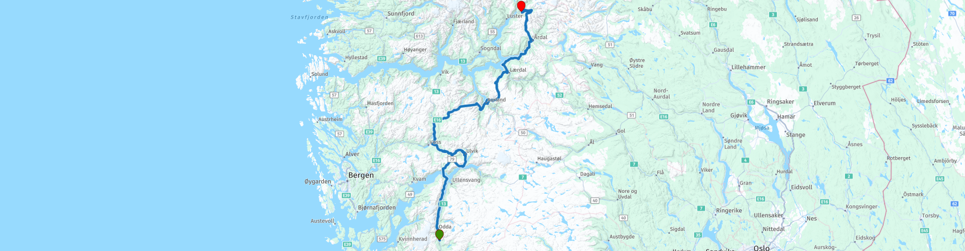
R05 Odda to Skjolden

This route was brought to you by:
RouteXpert Arno van Lochem - Senior RX
Last edit: 13-08-2024
 Route Summary
 This route starts at Hildal Camping, located just south of Odda.
The end point of this route is at Vassbakken kro og camping, a small campsite just east of Skjolden. A small campsite where you can pitch a tent or rent a cabin. There are several campsites in the area.
Along the way you will pass the Stegastein viewpoint and drive over the Tindevegen, Sognefjellet tourist route and the Autlandsfjellet.
The routes are easy to drive for everyone and (mostly) run on well-paved roads.
These routes through Norway use multiple ferries. Make it easy for yourself and use FerryPay. Most Norwegian ferries are affiliated with this, payment is fully automatic after scanning your license plate.
The Tindevegen you drive over in this route is a toll road. Prices 2024: Car NOK100,-, motorcycle NOK60,-More information can be found in the links at the bottom of this page.
Considering the excellent condition of the roads, the beautiful views and the wonderful mountain and rocky surroundings, I rate this route with 5 stars.
 Share this route


Animation

Verdict


Duration
10h 4m

Mode of travel
Car or motorcycle

Distance
343.92 km

Countries

 RouteXpert Review
 In the fifth part of this 13-part collection, you leave Odda and head further north. First, you have the chance to fill up the tank in the village if you haven't done so yet. It's not a bad idea to keep the tank reasonably full. On some parts of the route, you won't see a gas station for miles. When in doubt, fill up!
You’ve barely set off before you have a pleasant view of the Sørfjorden. This is a 38-kilometre-long fjord that is one of the innermost branches of the main Hardangerfjorden. It is located in the municipality of Ullensvang in Vestland county, Norway. It is the longest arm that branches off the Hardangerfjord. Sørfjorden stretches from just north of the village of Kinsarvik due south to the industrial town of Odda. The Folgefonna Glacier and Folgefonna National Park lie just west of the fjord, and the Hardangervidda mountain plateau lies to the east.
Speaking of the Folgefonna glacier, on the left side of the road you can see the Aednafossen. This is a waterfall on the Aedna river, which falls from a height of 325 meters into the Sørfjorden. At 170 meters wide, it is one of the widest waterfalls in Norway. The Aedna river is fed by the meltwater from the Folgefonna glaciers.
A few kilometres further on you will use the only ferry on this route, the boat from Utne - Kvenndal. It sails every half hour and takes you to the other side of the Hardangerfjorden in fifteen minutes. Where you leave the boat, the Granvinsfjorden begins again. This fjord is an arm of the Hardangerfjord in the municipalities of Granvin and Ullensvang. The fjord is about 10 kilometres long and the width is usually less than 1 kilometre. It has its inlet in the part of the Hardangerfjord known as the Inner Samla Fjord between two small peninsulas: Furenes near the village of Tjoflot on the east side and Håstabbenes on the west side. From there, the fjord runs northeast to the village of Granvin at the head of the fjord. The fjord has steep walls and is bordered by mountains up to 1,200 metres high. The route runs along the Granvinsfjorden to Granvin, so enjoy it to the fullest!
In Granvin you have the possibility to shorten the route a bit. You will then drive 35 kilometers less, which will save you 75 minutes in time. At the T-junction, turn left into the tunnel, you will then automatically end up on the route again.
After turning right in Granvin and exiting the tunnel (with a beautifully lit blue roundabout!), you drive a short distance along the Hardangerfjorden. This fjord is approximately 170 kilometres long and is the fifth largest fjord in the world. The fjord runs from the southwest to the northeast.
The only large islands in front of the fjord are Stord, Bømlo and Tysnesøy. The island of Varaldsøy is located in the fjord. The fjord is approximately 725 metres deep. Side arms of the Hardangerfjord are the Eidfjord and the Sørfjord.
If you find it interesting, you can find a spot to see the Hardanger Bridge in all its glory. This bridge spans the Eidfjorden, the eastern part of the Hardangerfjorden, and is the only fixed crossing across the fjord. The bridge has a total length of 1,380 meters and a main span of 1,310 meters. The bridge was built between February 2009 and August 2013 and replaced a nearby ferry service across the Hardangerfjorden. The bridge was opened on 17 August 2013.
After a few kilometres the route keeps left and you exchange the Hardangerfjorden for the Bagnsfjorden. The outer part of the Osa Fjord is also called the Bagnsfjorden, named after the headland where the fjord begins. A few kilometres further it branches off again into the Ulvikafjorden.
The Ulvikafjorden is an arm of the Osafjorden. It is six kilometres long and runs north from the inlet between Birgjetangen and Staursnes to the town of Ulvik. In the centre of Ulvik the fjord turns east and continues for another two kilometres. This inner part of the fjord is called Ulvikapollen. South of Ulvikapollen lies the village of Hjeltnes. National road 572 runs along the west side of the fjord.
In the town of Ulvik it is high time for a cup of coffee, where better to enjoy it than on the shore of the beautiful lake Ulvikapollen? Beautiful view over the lake and the mountain Kristinuten behind it?
A beautiful additional route that you can drive from Ulvik is the Osafjellsvegen. This road takes you to the high mountain lake Austdølnutvatnet. The (toll) road to it is truly amazing to drive. It is a dead end road, so you return the same way. However, that is no punishment considering the many beautiful things that can be seen along the way.
If you are interested in this, do not turn left at the T-junction after coffee, but turn right and follow the Tyssevikvegen. This soon turns into the Osavegen, after Osa the road narrows at some point and will continue as the Osafjellsvegen.
You will also come across a small wooden house, where you can pay the toll. There is an explanation of how to pay everything.
Please note that you will need at least an extra hour for this Osafjellsvegen, but it is an experience never to be forgotten!
After coffee and the possible excursion to Osafjellsvegen you continue the route, meandering through the Norwegian landscape. You will visit places like Vossevangen, Vinje and Flåm. Finally you will arrive in Aurlandsvangen. Shortly before this place you have the opportunity to fill the tank and the stomach. If in doubt, use this opportunity, there is no gas station in the next 50 kilometers.
At Aurlandsvangen you are on the Aurlandsvegen. On this road you drive on a narrow road along a wild river with numerous rapids and waterfalls. The road also starts to climb slowly until you reach the mountain massif, the natural border and barrier between Aurland and Lærdal. It goes steeply up with a number of hairpin bends. The road over the mountain massif is also called 'snøvegen'. Until the month of July you drive through a snow-covered area, only the road is snow-free. The road is closed in the winter, but the part from Aurlandsvangen is open all year round up to the viewpoint at Stegastein.
Stegastein Lookout is located 650 meters above the Aurlandsfjord and offers you a beautiful view of the fjord. The lookout is designed in such a way that it gives you the feeling of floating above the fjord. A special feature is the glass front of the lookout, which gives you an even better view.
From Stegastein you look into the 29 kilometre long Aurlandsfjord and the villages, one of the branches of the Sognefjord. The Sognefjord is with a length of 204 kilometres the longest fjord in Norway and one of the longest in the world. The village of Aurlandsvangen can also be seen from the lookout. You really do yourself a disservice if you don't stop here.
After enjoying a beautiful number of kilometres on the Aurlandsvegen, you exchange the view for the water of the Årdalsfjorden. The road along this road leads you via Naddvik to Øvre Årdal. In this place you have the opportunity to do some shopping at the local supermarket if desired. You can also arrange something to eat and/or drink at the adjacent petrol station.
Once you have left Øvre Årdal, you will be driving on Tindevegen. This road is the mountain road between Årdal and Turtagrø, a road that you follow for a distance of 32 kilometers. A tourist road that takes you from Sognefjorden to Jotunheimen. The road is also called “the shortcut through Jotunheimen” and is suitable for cars, campers and smaller buses (max 10m). The road is open from May to November.
Tindevegen is a toll road, the prices in 2024 are NOK 100 (€9,-) for a car, for a motorcycle you pay NOK 60,- (€5,50).
At the end of Tindevegen you turn left onto another phenomenal road, the tourist route Sognefjellet. You will only drive a short distance of this before you reach the end point, but it is already a very small foretaste of what is to come on the next route.
After completing the last 12 kilometers you will arrive at the end point of this route, the Vassbakken kro og camping. A not too big, quiet campsite where you can park your camper, tent or caravan. There are also cabins in various sizes for rent. In the background, just like at the Hildal campsite where the route started, a beautiful view over a waterfall, the Åsafossen waterfall.
Have fun riding this route!


 Links
Links  Usage
Usage Want to download this route?
You can download the route for free without MyRoute-app account. To do so, open the route and click 'save as'. Want to edit this route?
No problem, start by opening the route. Follow the tutorial and create your personal MyRoute-app account. After registration, your trial starts automatically.  Disclaimer
Use of this GPS route is at your own expense and risk. The route has been carefully composed and checked by a MyRoute-app accredited RouteXpert for use on TomTom, Garmin and MyRoute-app Navigation.
Changes may nevertheless have occurred due to changed circumstances, road diversions or seasonal closures. We therefore recommend checking each route before use.
Preferably use the route track in your navigation system. More information about the use of MyRoute-app can be found on the website under 'Community' or 'Academy'.

Hordaland
About this region
Hordaland (Urban East Norwegian: [ˈhɔ̂rdɑlɑn] (listen)) was a county in Norway, bordering Sogn og Fjordane, Buskerud, Telemark, and Rogaland counties. Hordaland was the third largest county after Akershus and Oslo by population. The county government was the Hordaland County Municipality which is located in Bergen. Before 1972, the city of Bergen was its own separate county apart from Hordaland. On 1 January 2020, the county was merged with neighbouring Sogn og Fjordane county to form the new Vestland county.
Read more on Wikipedia
View region
 Statistics
  8
8Amount of RX reviews (Hordaland)
 16710
16710Amount of visitors (Hordaland)
 698
698Amount of downloads (Hordaland)
 Route Collections in this region
 The Top 5 Car and Motorcycle Routes around the Norwegian Fjords
Norway, who doesn't want to go there by motorbike or by car (camper)? Norway, officially the Kingdom of Norway, is a country in Northern Europe. Norway is located on the western part of the Scandinavian Peninsula and borders Sweden, Finland and Russia.
Go to Norway, forget it! You don't go to Norway for a while, take at least 14 days to take in all the beauty of Norway. The 5 routes along Norway's most famous fjords can be the start of an unforgettable holiday. When it comes to natural beauty, Norway is certainly in the top ten of most desirable holiday countries. Fjords, snow-capped peaks, mirrored lakes: every square meter is a treat.
Some of the ANWB's Top 10 tips are included in these 5 routes, such as:
Preikestolen
Hint: Don't be afraid of heights when you visit Norway's most popular vantage point. Preikestolen is a super steep rock that towers 604 meters above the Lysefjord. In fact, you get two for the price of one, as the four-kilometer hike to the lookout is just as phenomenal. Preikestolen is even Norway's most popular hiking destination.
fjords
They are considered one of the world's most beautiful natural wonders: the imposing Norwegian fjords. Millions of years ago, they were eroded by huge masses of ice. It is an unforgettable experience to sail on a ship between the steep rock walls, but you can also admire the fjords from various vantage points. Spectacular include Geirangerfjord, Trollfjord, Sognefjord and Hardangerfjord. Certainly one of the most beautiful sights in Norway.
Trollstigen
The Trollstigen, also known as the Troll route, has what you would call the wow factor. On the 20 kilometer route you will experience no fewer than 11 hairpin bends; the average increase is 8 percent with a maximum of 10 percent. So a pill against motion sickness won't hurt… On the way it's a feast of waterfalls, steep mountain walls and fjords. Bonus: the beautiful view of the Geirangerfjord.
All routes in this collection have been checked and made equal for TomTom, Garmin and MyRoute-app Navigation!
Have fun with this collection and while driving one of these routes. Enjoy all the beauty that Norway has to offer. Click on “View route” to read the review of the chosen route.
View Route Collection
Top Car and Motorcycle tour through Sweden and Norway
Sweden and Norway are beautiful countries. You will find nice cities, but also impressive nature reserves. This versatility makes Sweden & Norway the perfect countries for an impressive motorcycle holiday.
In this collection 14 beautiful routes through Sweden & Norway.
Good preparation is half the battle, so read the tips below carefully.
1. Check the weather forecast. It can be very hot in Sweden & Norway, but it can also get very cold. Always check the weather forecast before you go, so that you can pack the right clothes.
2. Decide in advance which route or routes you want to follow. This way you don't drive around like a headless chicken and you can make the most of your days off in these beautiful countries.
3. Familiarize yourself with the traffic rules. In Sweden & Norway, in some situations, slightly different rules apply than in the Netherlands. By immersing yourself in the traffic rules, you prevent (unknowingly) committing a traffic violation and/or putting yourself in a dangerous situation.
It is also wise to book the accommodations in advance. It might be more fun to drive through these countries on spec, but you don't want to drive around endlessly to find a place to sleep. If you go to Sweden or Norway during the high season, the chance that you will have to look for a place to sleep is greatest. It is also possible to camp during your motorcycle trip, but find out in advance where this is and is not allowed. You are not allowed to pitch your tent everywhere.
As the largest country in Scandinavia, you can enjoy extensive tours in a unique environment. Forests, lakes, nature parks and agricultural areas largely determine the landscape, which also consists of flat areas and rolling hills. Around the Swedish-Norwegian border is the Scandinavian Highlands, where the mountains rise locally to 2100 meters.
Norway is known for its amazing natural beauty. Fjords that go into the country tens of kilometers deep, snow-covered plateaus, sharp mountain peaks and vast forests. In this sparsely populated country, most people live in the cities, of which the capital Oslo is the largest.
Tolls have to be paid on a large number of roads in Norway. If you approach a toll road, you can continue without stopping. With cameras above the road, the license plate of the vehicle is scanned, not the registration number of the trailer or caravan. It takes quite some time to process the photos.
The bill is then sent home within four to six months by Euro Parking Collection (EPC) in London.
Mandatory on the motorcycle: Safety vest - A motorcyclist must bring at least one safety vest. In the event of a breakdown or accident, the driver is obliged to wear a safety vest. The ANWB advises motorcyclists to also bring a safety vest for a possible passenger.
Advice: First aid kit, motorcyclists are advised to bring a first aid kit.
View Route Collection