R11 Roundtour Bodo to Lofoten part 3

This route was brought to you by:
RouteXpert Arno van Lochem - Senior RX
Last edit: 28-02-2021
 Route Summary
 You can also see this eleventh part as the last part of a three-part round trip from Bodø to and across the Lofoten.
The routes are easy for everyone to ride and are on well-paved roads. There may be a single hairpin bend to be taken, but these are easy to do.
If there is a piece of gravel in the route, a warning will be given and a detour will be indicated.
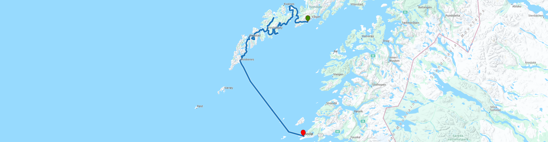
In this part you continue your journey across the Lofoten, an archipelago in the northeast of Norway. From Kabelvåg you drive across the islands of Gimsøya, Vestvågøy, Flakstadøya and Moskenesøya before taking the ferry to Bodø in Moskenes. Prepare for a lot of water, lots of fish and beautiful views of the beautiful surroundings.
The participants of the Arctic Challenge started in Bodø and received a first coordinate which is in Bjerkvik, north of Narvik. The next coordinate turned out to be at the ferry in Moskenes, where the crossing to Bodø could be started. The same evening they reported back to the hotel.
Beautiful scenery and views, beautiful roads and nice sights, hence the 4-star rating.
 Share this route


Animation

Verdict


Duration
10h 48m

Mode of travel
Car or motorcycle

Distance
291.27 km

Countries

 RouteXpert Review
 Of all western European countries, the Scandinavian countries probably have the most more or less untouched nature. In addition, they are countries that are easily accessible from the Netherlands. Norway is characterized by, among other things, the fjords and the Trollstigen, known to many motorcyclists. And where Sweden is known as wide and relaxing, everyone knows Finland as the land of 1000 lakes. All in all, legitimate reasons to traverse this beautiful nature in the north of Europe by means of a number of routes.
The Lofoten archipelago lies in the middle of the wild Norwegian Sea, well above the Arctic Circle. This special region offers a beautiful landscape with imposing mountains, deep fjords and long, wild sandy beaches where the sound of the seabird colonies can always be heard.
The archipelago is best known for its rich fishing tradition. Despite their isolated location, the Lofoten make a prosperous impression. The whole economy is above all about fishing. The image of the Lofoten is mainly dominated by wooden racks with cod hanging to dry. Lofoten fishing has been a household name for centuries. In the middle of winter the ships set sail to catch the fish in just a few months. The rich fishing grounds are due to the North Atlantic Gulf Stream around the islands, where the fish have their spawning grounds. No oil drilling is allowed around Lofoten and the cod spawning grounds there.
The route starts in Kabelvåg on the beautiful island of Austvågøy, the second island you visit in this tour of the Lofoten. It doesn't take long before you drive up the third island, Gimsøya. This is one of the smaller islands of Lofoten. The island can be reached over the Gimsøystraumen bru, a cantilevered bridge that crosses the Gimsøystraumen strait. The concrete bridge is 839 meters long, the main span is 148 meters and the maximum distance from the sea is 30 meters. The bridge has 9 spans. The Gimsøystraumen Bridge was opened in 1980. It is one of many bridges connecting the islands of Lofoten as part of the European highway E10 (also known as Lofast).
The route runs over the island of Gimsøya almost entirely along the coast, which gives you a beautiful view over the Vesterålsfjorden. As the road curves away from the coast, you have a view of the mountains in the distance, which is also a pleasant sight.
Do not forget to stop every now and then to enjoy the great nature around you, of which you also have to take some pictures.
The crossing to the next island that is part of the Lofoten, Vestvågøya, is done via the Sundklakkstraumen bru, a cantilevered road bridge that crosses the Sundklakkstraumen strait. The bridge is 271 meters long and the main span is 90 meters (300 feet) long. This bridge is also part of the Lofast project.
Shortly after the coffee break in Stamsund you have the opportunity to visit Skaftnes gård Museum. This is a beautifully situated museum between the sea and the green mountains of Lofoten, close to Sennesvik and Ure på Vestvågøy.
The farm consists of a farmhouse, barn, dock and boathouse. The buildings are open to visitors and a skilled guide is available. If you are interested in the history of Lofoten, this is the place to learn about fishermen and farmers who lived between the sea and some bare ground. Visit Skaftnes Farm for an authentic and genuine Lofoten experience.
In Leknes you will pass an Esso gas station with a decent shop. So if you want to buy something for the road, it is wise to do so here, the fuel stations along the remaining part of the route are all unmanned and do not have a shop.
After any refueling stop, turn right on the way to the Lofotr Viking Museum. Actually a must now that you are in Lofoten. The museum is a historical museum based on a reconstruction and archaeological excavation of a Viking chief's village. It is located in the small village of Borg, near Bøstad. In 1983, archaeologists discovered the Chieftain House, a large Viking-era building believed to have been built as far back as AD 500. Excavations revealed the largest Viking-era building ever found in Norway. The foundation of the Chieftain House in Borg was 83 meters long and 9.5 meters wide, and the reconstructed building is 30 feet high. The seat in Borg is estimated to have been abandoned around the year 950.
After the excavation ended, the remains of what had once been the longhouse remained visible. The longhouse has been reconstructed slightly to the north of the excavation site. In 1995 the Lofotr Viking Museum was opened. The museum includes a complete reconstruction of the 83 meter long chief house, a blacksmith shop, two ships (replicas of the Gokstad ship, one full size) and their boathouses, and several reenactments designed to immerse the visitor. in life at the time of the Vikings. The main building was designed by Norwegian architect Gisle Jakhelln.
This museum is definitely worth a visit, walking through the immense Viking house or sailing in a Viking ship is not something you do every day.
The next and penultimate island of the Lofoten that you will visit, Flakstadøya, can be reached via the Nappstraum tunnels. This single-tube tunnel is 1,776 meters long and runs under the Nappstraumen strait at a maximum depth of 63 meters. After the tunnel was opened in 1990, the crossing, which was done by ferry from 1956, could not be done over the water, but underneath it. Initially a toll was levied, but after enough toll was paid in 2003 to cover the costs of the construction, the toll was abolished, and since then there is free passage.
In Flakstad you will pass the Flakstad kirke, a parish church of the Church of Norway. The red wooden church was built in a cross shape in 1780. The church can accommodate 300 people.
The long, low church building is of rack and pinion construction with wood cladding on the outside with red-painted wood paneling, as was common at the end of the eighteenth century. The small windows have white frames. The roof is covered with tiles and a ridge dome with an onion dome and a spire crowns the crossing of the cross arms.
A beautiful building that is certainly worth stopping, especially for taking a picture.
After lunch at Ramberg you will come to the point where you can turn to visit the Lofotodden National Park. To do this, keep in the direction of Fredvang and keep following this road.
The park was established in 2018 and is 99 square kilometers in size. The park extends over 86 square kilometers of land and 13 square kilometers of water.
You can take a beautiful walk here, if you park your vehicle in the indicated parking lot. The path that leads you to the park starts at the parking lot. Don't expect a nicely paved path, but rather rocks and planks that you have to walk on. However, the view that is offered to you more than makes up for it.
A little further you reach the last island of this Lofoten tour, Moskenesøya. From this island you will soon also board the ferry that takes you to Bodø. Before that, however, you will first pass a number of sights that may be worthwhile. For example the viewpoint over the harbor of Hamnøya. You know them, those picturesque photos of the wooden fishing boats that are waiting in the harbor to set sail ... could have been taken here.
A little further a similar scene, but from the harbor of Reine. However, you drive into this village for a cup of coffee, the last coffee stop in Lofoten. There is an unmanned gas station, a single pump, so if necessary you can fill the tank here.
The asphalt over the last bridge of this island, the Djupfjordbrua, ensures that you get to the other side of the Djupfjorden without wet feet. Just after the bridge there is a viewpoint that gives a nice view over the bridge, but also over the water. Definitely stop to enjoy the beauty that Lofoten has to offer one last time.
Two kilometers further, you can already see the ferry with a bit of luck, you can still choose to drive a short distance to the Lofoten tørrfiskmuseum in the town of Å. No doubt you have seen many racks along the way, depending on the time of year you are here they were filled with cod. In the Lofoten tørrfiskmuseum they can tell you everything about this stockfish, or unsalted dried cod.
Fishermen set out to hunt for skrei, the cod that migrates every year from the Barents Sea to the coast of Northern Norway to spawn. The large cod species can be found mainly along the coast of Lofoten, Senja and Vesterålen, between January and April.
The skrei's long journey ensures that their flesh is firmer than that of the common cod, which often stays in one place. The white, mild flesh is so tender that it comes off when you stir it gently with a fork.
In the museum they can tell you all about this important source of income in Lofoten, where you can see everywhere the racks on which you can see cod tied together in pairs to be dried in the open air. They call it the gold of the Lofoten. The inhabitants of Lofoten do not say it smells like fish. No, it smells like money.
Arriving in Moskenes, a 3.5-hour boat trip awaits you to take you back to the city where the Lofoten tour started, Bodø. The route ends at the same hotel where the tour started, the Skagen Hotel.
Two campsites are indicated for campers in the vicinity of the end point: Bodøsjøen Camping and Geitvågen Bad & Camping.
Have fun driving this route!


 Links
Links  Usage
Usage Want to download this route?
You can download the route for free without MyRoute-app account. To do so, open the route and click 'save as'. Want to edit this route?
No problem, start by opening the route. Follow the tutorial and create your personal MyRoute-app account. After registration, your trial starts automatically.  Disclaimer
Use of this GPS route is at your own expense and risk. The route has been carefully composed and checked by a MyRoute-app accredited RouteXpert for use on TomTom, Garmin and MyRoute-app Navigation.
Changes may nevertheless have occurred due to changed circumstances, road diversions or seasonal closures. We therefore recommend checking each route before use.
Preferably use the route track in your navigation system. More information about the use of MyRoute-app can be found on the website under 'Community' or 'Academy'.

Nordland
About this region
Nordland (Norwegian pronunciation: [ˈnûːrlɑn] (listen); Lule Sami: Nordlánnda, Southern Sami: Nordlaante, Northern Sami: Nordlánda, English: Northland) is a county in Norway in the Northern Norway region, bordering Troms og Finnmark in the north, Trøndelag in the south, Norrbotten County in Sweden to the east, Västerbotten County to the southeast, and the Atlantic Ocean (Norwegian Sea) to the west. The county was formerly known as Nordlandene amt. The county administration is in the town of Bodø. The remote Arctic island of Jan Mayen has been administered from Nordland since 1995. In the southern part of the county is Vega, listed on the UNESCO World Heritage Site list.
Read more on Wikipedia
View region
 Statistics
  16
16Amount of RX reviews (Nordland)
 14965
14965Amount of visitors (Nordland)
 783
783Amount of downloads (Nordland)
 Route Collections in this region
 In 12 Days from Oslo to the North Cape
This is a route collection of a motorcycle tour from Oslo to the North Cape, based on a journey by Thomas Falck Østli. A total of twelve routes have been described, but the tour can be extended to more days, more information about this in the reviews.
The routes run through the beautiful landscapes of Norway, including the Lofoten, with many lakes, fjords, rivers, beautiful bridges, beautiful green forests and rugged mountains. During the trip there are also many ferry crossings, keep this in mind in your planning.
You drive longer distances in Norway without encountering a gas station or a restaurant, keep this in mind before you drive. Make sure your tank is full and bring food and drinks. Bring a few bottles of water or Camel bag and fill it up when you stop to refuel. Along the way, breaks are planned for refueling, eating and drinking.
The total trip of almost 3700 kilometers is broken down as follows;
• Day 1 is a 434 kilometer drive from Oslo to Geiranger
• Day 2 is a 238 kilometer drive from Geiranger to Kristiansund
• Day 3 is a 298 kilometer drive from Kristiansund via Trondheim to Verdal
• Day 4 is a 333 kilometer drive from Verdal to Brønnøysund
• Day 5 is a 267 kilometer drive from Brønnøysund to Furøy
• Day 6 is a 296 kilometer drive from Furøy Lofoten to Reine
• Day 7 is a 218 kilometer drive from Reine to Ørsvågvær
• Day 8 is a 274 kilometer drive from Ørsvågvær to Straumsjøen
• Day 9 is a 327 kilometer drive from Straumsjøen to Senjahopen
• Day 10 is a 321 kilometer drive from Senjahopen to Tromsø
• Day 11 is a 420 kilometer drive from Tromsø to Alta
• Day 12 is a 239 km drive from Alta via the North Cape to Skarsvåg
You have the choice to stay overnight at campsites or in hotels. Hotel prices in Norway are not particularly high and breakfast is usually included.
Camping is free almost everywhere, except on private property or where camping is prohibited, indicated by prohibition signs.
If you don't want to camp, there are often cabins for rent on the campsites. For a trip through Norway it is always advisable to bring a tent and other camping gear.
Information about hotels and campsites is included in the directions
Have fun reading, planning and driving this scenic journey to the northernmost tip of Europe.
View Route Collection
6500 kilometers through Scandinavia with the highlights of the Lofoten and the North Cape
The Arctic Challenge Tour, on which this 26-part tour is partly based, is not a speed race. It's a tour. It comes down to agility, good navigation and anticipation. The participants are obliged to adhere to the speed limit of the country concerned. The participants must find the ideal route with the shortest possible distance by complying 100% with the locally applicable traffic rules. Of course, also take maximum speeds into account. The organization checks for violations of the speed limit. In case of gross or repeated exceeding of the maximum speed, disqualification for the relevant stage and for the final classification will follow. Control of the route and speeds is done by means of a track and trace system. This equipment is installed in every vehicle. You can then follow each team accurately in the Back Office. Those staying at home, interested parties and participants can also see the performances of the teams, because you can be followed live via the Internet. The Back Office takes action when a team gets into trouble. (source: website The Arctic Challenge)
That's quite a luxury, having a back office behind you that keeps an eye on you. Most of us will not have that and are on our own or the fellow traveler(s). The only agreement you have with the participants is that you also have to abide by the rules. Fortunately, you don't have to complete this tour in 9 days, like the participants, but you can take it a little longer.
The highlight of the Arctic Challenge in 2020 was the Lofoten, an island group northwest of Norway. The Lofoten archipelago is located in the middle of the wild Norwegian Sea, well above the Arctic Circle. This special region offers a beautiful landscape with imposing mountains, deep fjords and long, wild sandy beaches where the sound of the seabird colonies can always be heard.
The archipelago is best known for its rich fishing tradition. The Lofoten makes a prosperous impression despite their isolated location. The entire economy revolves above all around fishing. The image of the Lofoten is mainly dominated by wooden racks with cod, which hangs to dry. Lofoten fishing has been a household name for centuries. In the middle of winter, the ships set out to catch the fish in just a few months. The rich fishing grounds are due to the North Atlantic Warm Gulf Stream around the islands, in which the fish have their spawning grounds. Oil drilling is not permitted around Lofoten and the cod spawning grounds there.
The next destination for the participants was Sirkka, also known as Levi, a winter sports resort in Finnish Lapland. They stayed there for a few days to go ice-karting and to enjoy the snow by going on a snowmobile or skiing trip. This tour also takes you to Sirkka, but instead of staying there for a few days, you have the option to continue to the North Cape, the second highlight of this trip.
Imagine a place in the far north, where the Atlantic Ocean meets the icy waters of the Arctic Ocean. This place is the North Cape in Western Finnmark in Northern Norway. From here, only the archipelago of Spitsbergen lies between you and the North Pole and the sun shines for 2.5 months at a time; from mid-May to the end of July. Many visitors admire the midnight sun or the sunset over the Barents Sea from the North Cape plateau.
With each route you will find a review with a description of the route, where you pass and what to see along the way. It is also briefly described how the participants in the Arctic Challenge in 2020 had to drive it anyway, from which point to which point. Along the way, markings (route points) have been included that indicate the end points of the stages that the participants had to complete. As mentioned, they covered the distance in 9 days, stages of more than 1000 kilometers were no exception.
Each route ends at a hotel. It is of course not an obligation to use these hotels, you can always find another place to stay in the area, that decision is up to you. My experience, however, is that they are all simple but good hotels for a very reasonable price. They are known and can be booked at booking.com.
The routes of these collections:
R01 - Puttgarden to Angelholm, 280km
R02 - Angelholm to Alingsas, 281km
R03 - Alingsas to Mysen, 261km
R04 - Mysen to Rena, 312km
R05 - Rena to Orkanger, 306km
R06 - Orkanger to Grong, 292km
R07 - Grong to Mo i Rana, 290km
R08 - Mo i Rana to Bodo, 231km
R09 - Roundtour Bodo to Lofoten part 1, 314km
R10 - Roundtour Bodo to Lofoten part 2, 250km
R11 - Roundtour Bodo to Lofoten part 3, 291km
R12 - Bodo to Arjeplog, 295km
R13 - Arjeplog to Jokkmokk, 244km
R14 - Jokkmokk to Pajala, 239km
R15 - Roundtour Sirkka to North Cape part 1, 257km
R16 - Roundtour Sirkka to North Cape part 2, 300km
R17 - Roundtour Sirkka to North Cape part 3, 244km
R18 - Roundtour Sirkka to North Cape part 4, 275km
R19 - Roundtour Sirkka to North Cape part 5, 332km
R20 - Sirkka to Kemi, 299km
R21 - Kemi to Ylivieska, 251km
R22 - Ylivieska to Jalasjarvi, 236km
R23 - Jalasjarvi to Turku, 279km
R24 - Stockholm to Askersund, 271km
R25 - Askersund to Varnamo, 224
R26 - Varnamo to Trelleborg, 259km
Have fun driving these routes!
View Route Collection