R10 Roundtour Bodo to Lofoten part 2

This route was brought to you by:
RouteXpert Arno van Lochem - Senior RX
Last edit: 27-02-2021
 Route Summary
 You can also see this tenth part as part two of a three-part round trip from Bodø to and across the Lofoten.
The routes are easy for everyone to ride and are on well-paved roads. There may be a single hairpin bend to be taken, but these are fine.
If there is a piece of gravel in the route, a warning will be given and a detour will be indicated.
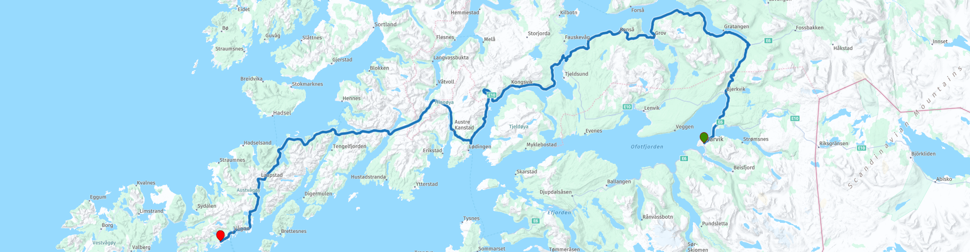
In this part you finally drive over the Lofoten, an archipelago in the northeast of Norway. From Narvik you leave for Bjerkvik, from where you can make a beautiful tour over the islands of Hinnøya and Austvågøy. Prepare yourself for lots of water, lots of fish and beautiful views of the beautiful surroundings.
The participants of the Arctic Challenge started in Bodø and received a first coordinate which is in Bjerkvik, north of Narvik. The next coordinate turned out to be at the ferry in Moskenes, where the crossing to Bodø could begin. The same evening they reported back to the hotel.
Beautiful scenery and views, beautiful roads and nice sights, hence the 4-star rating.
 Share this route


Animation

Verdict


Duration
6h 55m

Mode of travel
Car or motorcycle

Distance
250.48 km

Countries

 RouteXpert Review
 Of all western European countries, the Scandinavian countries probably have the most more or less untouched nature. In addition, they are countries that are easily accessible from the Netherlands. Norway is characterized by, among other things, the fjords and the Trollstigen, known to many motorcyclists. And where Sweden is known as wide and relaxing, everyone knows Finland as the land of 1000 lakes. All in all, legitimate reasons to traverse this beautiful nature in the north of Europe by means of a number of routes.
The Lofoten archipelago lies in the middle of the wild Norwegian Sea, well above the Arctic Circle. This special region offers a beautiful landscape with imposing mountains, deep fjords and long, wild sandy beaches where the sound of the seabird colonies can always be heard.
The archipelago is best known for its rich fishing tradition. Despite their isolated location, the Lofoten make a prosperous impression. The whole economy is above all about fishing. The image of the Lofoten is mainly dominated by wooden racks with cod hanging to dry. Lofoten fishing has been a household name for centuries. In the middle of winter the ships set sail to catch the fish in just a few months. The rich fishing grounds are due to the North Atlantic Gulf Stream around the islands, where the fish have their spawning grounds. No oil drilling is allowed around Lofoten and the cod spawning grounds there.
The route starts in Narvik at the Scandic Narvik hotel. Within the first kilometer you will pass a gas station where you can fill the tank if you have not already done so. There is also a supermarket on the same square, so if you want to stock up on the road, that is quite possible here.
Just outside Narvik you can almost immediately see a large bridge, the Hålogalandsbrua. This is a suspension bridge over the Rombaken, a bay of the Ofotfjord. It is also the longest suspension bridge above the Arctic Circle. Before this bridge was built, it was necessary to make a detour over the Rombak Bridge, which, due to the technical limitations of the time, is located about 9 kilometers eastward. The bridge was opened on December 9, 2018. After this, the route of the E6 was moved from the Rombak Bridge to the Hålogalands Bridge, shortening the route by 17 kilometers.
The E6 offers you beautiful views of the fjords and the landscape along the way. Great to see, especially when the weather is nice, windless. The reflections in the water from the other side remain beautiful to see. There are several places marked to stop to stretch your legs, make sure to use the opportunity to enjoy the view and take pictures at those places.
At Gratangsbotn you will (almost) pass the North Norwegian Boat Museum, or the North Norwegian Boat Museum. Up close you can see how old boats are being restored for a next life. Gratangen is a traditional fishing and hunting community, from here fishing has taken place in Lofoten, outside of Senja and Finnmarka, as well as on the shores of the Atlantic Ocean. In the past, many boats from Gratangen also participated in the seal hunt. Then it is no wonder that both old boats and objects from fishing have been collected here.
Ten kilometers further along the route you can visit the North Norwegian Maritime Protection Center, roughly translated as the North Norwegian Ship Protection Center. The term ship protection is mainly used for the active use of preserving cultural-historical vessels in a floating state. This form of protection began in the 1960s with ships such as the rescue boat Colin Archer, the schooner Svanen, the wheeled steamboat Skibladner and the local boat Børøysund.
The center mainly carries out ship carpentry for major restoration projects. During a restoration, most parts of the ship can be modified, and keel and bow changes, decks and rig work are carried out, as well as interior work.
One of the special areas for the center is the restoration of semi-diesel engines. For example, 10 semi-diesel engines have been completely overhauled or restored. The engines were of the Brunvoll (2), Union, Volda, Rapp, Sabb, Normo, Finnøy, Heimdal and Wichmann types. In addition, repairs have been carried out on a number of different engines. In addition to forging, the workshop is equipped with machines for most operations. Wear parts such as bearings and piston rings can be produced.
After this piece of culture you drive further along the coast with again great views over the water. Driving too much to look at the water is of course not sensible, which is why several parking spaces have been constructed along this road. Take advantage of that to enjoy the surroundings!
After the first coffee break you drive along the Skulpturlandskap Nordland (Skånland). In the middle of no man's land, right on the water is the sculpture '7 Magical Points'. This is a beautiful and mystical round iron sculpture, 7 meters in diameter and weighing 25 tons. The location is as mentioned along the coastline overlooking the midnight sun in a picturesque setting. The artwork was created by Martti Aiha.
Be careful when visiting, the 'path' to it is not exactly flat.
After driving 100 kilometers you can stop for the second coffee break. A special place, because from this point you actually only enter the Lofoten. First you put 'wheel' on Hinnøya. This island is Norway's largest island, apart from the islands that belong to Spitsbergen. The island is 2204.7 km² in size. Slightly more than half belongs to the province of Nordland, the smaller part belongs to the province of Troms og Finnmark. It is divided over eight municipalities in total.
Hinnøya is connected to the mainland by the Tjeldsund bridge (1007 meters) over the Tjeldsund. The bridge is part of the E10. The highest point is at 1262 meters: Møysalen.
The route goes through the Sørdalstunnel, a 6338 meter long single tube tunnel. The E10 runs through the tunnel from Lodingen to Svolvær. The tunnel is in a remote area, there are no villages in the area. The tunnel is also located on a slope, from east to west the height difference is 90 meters.
The tunnel was constructed as the last part of the 51-kilometer Lofast project, which gave Lofoten a permanent cross-river connection with the rest of Norway. This project started in 1993, but the tunnel itself was built between 2004 and 2007 and opened to traffic on December 1, 2007. This project made the ferry services in the area obsolete, although the route from Bodø via the ferry service is faster than the huge detour via the E6 and E10.
Shortly after, you cross the Øksfjorden via two bridges and a small island called Husjordøya and drive on the last piece of land belonging to Hinnøya. Again a bit through a tunnel, although it is not as long as the Sørdalstunnel. It concerns the Raftsund Tunnels with a length of 1530 meters. The tunnel was opened to traffic on December 1, 2007. This tunnel also belongs to Lofast.
The connection from Hinnøya to Austvågøy, the second island of Lofoten that you drive over, is formed by the Raftsund bridge, which is also part of Lofast. This bridge was opened in 1998. It is a gently sloping, elegant concrete bridge spanning the rugged landscape of Hinnøya and Austvågøy in Lofoten. The thin, elegant pillars on which the bridge rests are not very prominent in the visual image.
It is a concrete span bridge, built according to the 'cantilever method'. In this construction method, both sides are built simultaneously from a fixed end (pillar), until the two parts meet in the middle. When the ends meet, the bridge is connected and the load is distributed between both headrests. Very often, a casting cart is used for work with formwork for a certain section. Once it is formed, the carriage is pushed forward. In English this way of building is called cantilever style, or projecting outwards. All foundations / scaffolding heads placed on the mountain are recessed into the terrain to minimize site degradation.
Once you arrive in Austvågøy, it doesn't take long before you enter the next part of the Lofast project: The Myrlands Tunnel. This tunnel runs between Falkfjorden and Myrlandsfjorden. The tunnel is 1965 meters long and opened to traffic in December 1997.
Shortly after leaving this tunnel, the next (and last) tunnel in this route looms up, the Sløverfjordtunnel. This single-tube tunnel with a length of 3337 meters goes under the Sløverfjord at a maximum depth of 112 meters below sea level. The strongest slope is 8%. It will not surprise you that this tunnel is also part of Lofast.
The tunnel was built in the mid-1990s and opened to traffic on December 19, 1997. In the early years the tunnel was still of little importance and traffic went via the ferry service Melbu - Fiskebøl, the Hadselbrua and the Sortlandsbrua, a northern route. Since 2007, the tunnel has become more important when the Lofast project was completed.
Almost at the end of the route you will pass the Austnesfjorden viewpoint. This point is beautifully landscaped. To give you the maximum view over the fjord, various platforms and stairs have been built between the rocks. Wonderful place to stay and of course take some nice pictures.
When you arrive in Svolvær you can visit the Lofoten Krigsminnemuseumm. The Lofoten War Museum offers the largest display of rare uniforms and artifacts from the Second World War. The exhibition offers a unique historical snapshot of these five dramatic years, telling the war story in a unique, personal and engaging way. Many rare objects are featured.
The museum is getting great feedback from all over the world, and as one war veteran said, "Must be one of the best in the world - maybe the best!"
After refilling the fuel tank you will arrive at Kabelvåg, the final destination of this route. To be precise at Kabelvåg Vandrerhjem, a simple but good hostel. You can eat at one of the restaurants in Kabelvåg.
Three campsites are indicated for campers in the vicinity of the end point: Kabelvåg Feriehus & Camping, Lofoten Turist og Rorbusenter Ørsvågvær and Sandvika Fjord og Sjøhuscamping.
If you still have time, you can take a look at the Lofotmuseet or the adjacent Lofotakvariet. In the Lofotmuseet you can experience the history of the Lofoten fisherman on one of the best preserved farms in Lofoten. You will find the stately main building from 1815, authentic fishing huts and a boathouse with Nordland boats.
The museum offers slideshows and exhibitions on Lofoten fishing, harbors and lighthouses along the coast, traditional crafts and a beautiful garden with historic perennials. Guided tours are by appointment.
In Lofotakvariet you can learn more about Lofoten cod or cod, the East Atlantic cod that migrate from the Barents Sea to Lofoten every winter to spawn, and then form the basis for fishing in Lofoten. Cod is used to produce stockfish (you must see the drying racks along the way) and salted fish, and it has been one of the most important food fish in Europe for centuries. At the Lofoten Aquarium you can also study most of the other fish species, crustaceans and marine life in the marine areas around Lofoten. In addition, you can experience an exhibition about coexistence in the marine areas with information about fishing, aquaculture and oil and gas activities in Norway.
At Lofotakvariet there is a swimming pool with seals and a separate canopy for otters. One of the highlights of a visit is feeding the seals and otters. The Lofoten Aquarium has photo exhibitions and movies, it is possible to buy Lofoten souvenirs in the aquarium shop and enjoy a coffee and the great view from the cafe.
Have fun driving this route!


 Links
Links  Usage
Usage Want to download this route?
You can download the route for free without MyRoute-app account. To do so, open the route and click 'save as'. Want to edit this route?
No problem, start by opening the route. Follow the tutorial and create your personal MyRoute-app account. After registration, your trial starts automatically.  Disclaimer
Use of this GPS route is at your own expense and risk. The route has been carefully composed and checked by a MyRoute-app accredited RouteXpert for use on TomTom, Garmin and MyRoute-app Navigation.
Changes may nevertheless have occurred due to changed circumstances, road diversions or seasonal closures. We therefore recommend checking each route before use.
Preferably use the route track in your navigation system. More information about the use of MyRoute-app can be found on the website under 'Community' or 'Academy'.

Troms
About this region
Troms (Norwegian: [trʊms] (listen); Northern Sami: Romsa; Kven: Tromssa; Finnish: Tromssa) is a former county in northern Norway. On 1 January 2020 it was merged with the neighboring Finnmark county to create the new Troms og Finnmark county. This merger is expected to be reversed by the government resulting from the 2021 Norwegian parliamentary election.It bordered Finnmark county to the northeast and Nordland county in the southwest. Norrbotten Län in Sweden is located to the south and further southeast is a shorter border with Lapland Province in Finland. To the west is the Norwegian Sea (Atlantic Ocean).
The entire county, which was established in 1866, was located north of the Arctic Circle. The Troms County Municipality was the governing body for the county, elected by the people of Troms, while the Troms county governor was a representative of the King and Government of Norway. The county had a population of 161,771 in 2014.
Read more on Wikipedia
The entire county, which was established in 1866, was located north of the Arctic Circle. The Troms County Municipality was the governing body for the county, elected by the people of Troms, while the Troms county governor was a representative of the King and Government of Norway. The county had a population of 161,771 in 2014.
View region
 Statistics
  6
6Amount of RX reviews (Troms)
 7788
7788Amount of visitors (Troms)
 309
309Amount of downloads (Troms)
 Route Collections in this region
 In 12 Days from Oslo to the North Cape
This is a route collection of a motorcycle tour from Oslo to the North Cape, based on a journey by Thomas Falck Østli. A total of twelve routes have been described, but the tour can be extended to more days, more information about this in the reviews.
The routes run through the beautiful landscapes of Norway, including the Lofoten, with many lakes, fjords, rivers, beautiful bridges, beautiful green forests and rugged mountains. During the trip there are also many ferry crossings, keep this in mind in your planning.
You drive longer distances in Norway without encountering a gas station or a restaurant, keep this in mind before you drive. Make sure your tank is full and bring food and drinks. Bring a few bottles of water or Camel bag and fill it up when you stop to refuel. Along the way, breaks are planned for refueling, eating and drinking.
The total trip of almost 3700 kilometers is broken down as follows;
• Day 1 is a 434 kilometer drive from Oslo to Geiranger
• Day 2 is a 238 kilometer drive from Geiranger to Kristiansund
• Day 3 is a 298 kilometer drive from Kristiansund via Trondheim to Verdal
• Day 4 is a 333 kilometer drive from Verdal to Brønnøysund
• Day 5 is a 267 kilometer drive from Brønnøysund to Furøy
• Day 6 is a 296 kilometer drive from Furøy Lofoten to Reine
• Day 7 is a 218 kilometer drive from Reine to Ørsvågvær
• Day 8 is a 274 kilometer drive from Ørsvågvær to Straumsjøen
• Day 9 is a 327 kilometer drive from Straumsjøen to Senjahopen
• Day 10 is a 321 kilometer drive from Senjahopen to Tromsø
• Day 11 is a 420 kilometer drive from Tromsø to Alta
• Day 12 is a 239 km drive from Alta via the North Cape to Skarsvåg
You have the choice to stay overnight at campsites or in hotels. Hotel prices in Norway are not particularly high and breakfast is usually included.
Camping is free almost everywhere, except on private property or where camping is prohibited, indicated by prohibition signs.
If you don't want to camp, there are often cabins for rent on the campsites. For a trip through Norway it is always advisable to bring a tent and other camping gear.
Information about hotels and campsites is included in the directions
Have fun reading, planning and driving this scenic journey to the northernmost tip of Europe.
View Route Collection
6500 kilometers through Scandinavia with the highlights of the Lofoten and the North Cape
The Arctic Challenge Tour, on which this 26-part tour is partly based, is not a speed race. It's a tour. It comes down to agility, good navigation and anticipation. The participants are obliged to adhere to the speed limit of the country concerned. The participants must find the ideal route with the shortest possible distance by complying 100% with the locally applicable traffic rules. Of course, also take maximum speeds into account. The organization checks for violations of the speed limit. In case of gross or repeated exceeding of the maximum speed, disqualification for the relevant stage and for the final classification will follow. Control of the route and speeds is done by means of a track and trace system. This equipment is installed in every vehicle. You can then follow each team accurately in the Back Office. Those staying at home, interested parties and participants can also see the performances of the teams, because you can be followed live via the Internet. The Back Office takes action when a team gets into trouble. (source: website The Arctic Challenge)
That's quite a luxury, having a back office behind you that keeps an eye on you. Most of us will not have that and are on our own or the fellow traveler(s). The only agreement you have with the participants is that you also have to abide by the rules. Fortunately, you don't have to complete this tour in 9 days, like the participants, but you can take it a little longer.
The highlight of the Arctic Challenge in 2020 was the Lofoten, an island group northwest of Norway. The Lofoten archipelago is located in the middle of the wild Norwegian Sea, well above the Arctic Circle. This special region offers a beautiful landscape with imposing mountains, deep fjords and long, wild sandy beaches where the sound of the seabird colonies can always be heard.
The archipelago is best known for its rich fishing tradition. The Lofoten makes a prosperous impression despite their isolated location. The entire economy revolves above all around fishing. The image of the Lofoten is mainly dominated by wooden racks with cod, which hangs to dry. Lofoten fishing has been a household name for centuries. In the middle of winter, the ships set out to catch the fish in just a few months. The rich fishing grounds are due to the North Atlantic Warm Gulf Stream around the islands, in which the fish have their spawning grounds. Oil drilling is not permitted around Lofoten and the cod spawning grounds there.
The next destination for the participants was Sirkka, also known as Levi, a winter sports resort in Finnish Lapland. They stayed there for a few days to go ice-karting and to enjoy the snow by going on a snowmobile or skiing trip. This tour also takes you to Sirkka, but instead of staying there for a few days, you have the option to continue to the North Cape, the second highlight of this trip.
Imagine a place in the far north, where the Atlantic Ocean meets the icy waters of the Arctic Ocean. This place is the North Cape in Western Finnmark in Northern Norway. From here, only the archipelago of Spitsbergen lies between you and the North Pole and the sun shines for 2.5 months at a time; from mid-May to the end of July. Many visitors admire the midnight sun or the sunset over the Barents Sea from the North Cape plateau.
With each route you will find a review with a description of the route, where you pass and what to see along the way. It is also briefly described how the participants in the Arctic Challenge in 2020 had to drive it anyway, from which point to which point. Along the way, markings (route points) have been included that indicate the end points of the stages that the participants had to complete. As mentioned, they covered the distance in 9 days, stages of more than 1000 kilometers were no exception.
Each route ends at a hotel. It is of course not an obligation to use these hotels, you can always find another place to stay in the area, that decision is up to you. My experience, however, is that they are all simple but good hotels for a very reasonable price. They are known and can be booked at booking.com.
The routes of these collections:
R01 - Puttgarden to Angelholm, 280km
R02 - Angelholm to Alingsas, 281km
R03 - Alingsas to Mysen, 261km
R04 - Mysen to Rena, 312km
R05 - Rena to Orkanger, 306km
R06 - Orkanger to Grong, 292km
R07 - Grong to Mo i Rana, 290km
R08 - Mo i Rana to Bodo, 231km
R09 - Roundtour Bodo to Lofoten part 1, 314km
R10 - Roundtour Bodo to Lofoten part 2, 250km
R11 - Roundtour Bodo to Lofoten part 3, 291km
R12 - Bodo to Arjeplog, 295km
R13 - Arjeplog to Jokkmokk, 244km
R14 - Jokkmokk to Pajala, 239km
R15 - Roundtour Sirkka to North Cape part 1, 257km
R16 - Roundtour Sirkka to North Cape part 2, 300km
R17 - Roundtour Sirkka to North Cape part 3, 244km
R18 - Roundtour Sirkka to North Cape part 4, 275km
R19 - Roundtour Sirkka to North Cape part 5, 332km
R20 - Sirkka to Kemi, 299km
R21 - Kemi to Ylivieska, 251km
R22 - Ylivieska to Jalasjarvi, 236km
R23 - Jalasjarvi to Turku, 279km
R24 - Stockholm to Askersund, 271km
R25 - Askersund to Varnamo, 224
R26 - Varnamo to Trelleborg, 259km
Have fun driving these routes!
View Route Collection