R26 Varnamo to Trelleborg

This route was brought to you by:
RouteXpert Arno van Lochem - Senior RX
Last edit: 18-05-2021
 Route Summary
 The routes are easy for everyone to drive and are on well-paved roads. It may be necessary to take a single hairpin bend, but these are perfectly doable.
If there is a piece of gravel in the route, a warning will be given and, if possible, a detour will be indicated.
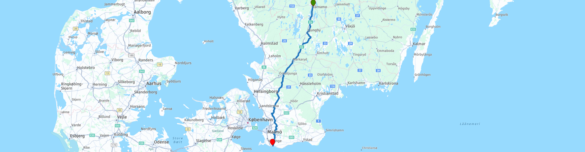
The route starts in Värnamo, located on the north side of Lake Vidöstern. The first part you drive along this lake descending south. Once you have left the lake behind you, you drive on (partly) nice back roads to the final destination of this route, Trelleborg.
Beautiful and interesting sights include the funeral museum, an old state prison and a city visit in Lund.
This tour also ends in Trelleborg and you have covered 6500 kilometers. From here you can decide for yourself how you are going to undertake the return journey home, there are various destinations possible by ferry.
Beautiful rugged landscape, beautiful scenic views, tight roads and beautiful sights, hence the 4-star rating.
 Share this route


Animation

Verdict


Duration
8h 53m

Mode of travel
Car or motorcycle

Distance
259.29 km

Countries

 RouteXpert Review
 Of all western European countries, the Scandinavian countries probably have the most more or less untouched nature. In addition, they are countries that are easily accessible from the Netherlands. Norway is characterized by, among other things, the fjords and the Trollstigen known to many motorcyclists. And where Sweden is known as wide and peaceful, everyone knows Finland as the land of 1000 lakes. All in all, legitimate reasons to traverse this beautiful nature in the north of Europe by means of a number of routes.
The participants of the Arctic Challenge are on their way from Stockholm to Hamburg, a journey of about 1000 kilometers. She awaits one more night in Hamburg. After that overnight stay, it is now the last of the challenge, they will return to the starting point, Twente air base in Enschede.
However, the coordinates they receive are close to the border between Nordhorn and Denekamp. In the parking lot, the tracking devices, which have ensured that the participants have all been via a website, are being expanded. After this action they drive in a column to the airbase where they are met by family, friends and acquaintances.
The route starts in the town of Värnamo, which is located at the northern tip of Lake Vidöstern. Värnamo is the capital of the municipality of Värnamo in the Småland countryside and the province of Jönköpings län in Sweden. The place has 18 469 inhabitants (2005) and an area of 1189 hectares.
During the first 30 kilometers of the route, you drive along the shore of Lake Vidöstern. This is a lake in the Swedish landscape of Småland and the province of Jönköpings län. The lake has an elongated shape, has an area of 45 km², is located 144 meters above sea level and has a maximum depth of 45 meters. The river Lagan runs through the lake.
For a long time iron ore was extracted from the bottom of the lake. After this was initially done manually from the ice sheet that was closed in winter, excavators were used from 1909. In 1922 one of the excavators sank, but it was recovered. In 1932, another excavator sank in a storm, but it was not salvaged. In 1942 ore mining was ended.
In the town of Ljungby, through which the route passes, you have the chance to visit the funeral museum. Sounds a bit gloomy and perhaps lugubrious, but it is still interesting to see how the funerals have changed over the years.
The funeral museum in Ljungby shows customs and customs in death and burial in the 19th and 20th centuries. In small room settings, death and burial during these two centuries are shown and told.
During the 19th century and well into the 20th century, death was constantly present in every person. And when it happened, they helped each other, neighbors and relatives, with whatever needed to be done. It was a mixture of practical necessities, church customs and shock that formed the basis for the ceremonies and rituals. At the funeral museum in Ljungby you have the opportunity to see and learn how it happened.
Although it is a topic that you might prefer not to think about, it can still be interesting to take a look here.
You continue towards the end of this last route in the 26-part tour through Scandinavia. You pass small places where a coffee stop or lunch break is planned. Also an occasional viewpoint over a beautiful lake or other attraction. After having completed more than 200 kilometers of the route, you will arrive in the town of Lund. Lund is the capital of the municipality of Lund in the Swedish landscape of Skåne and the county of Skåne län. The place has 82,800 inhabitants (as of 2010) and an area of 24.99 km2.
Lund has existed since about 990. It is home to 27 churches and monasteries, some of which are now museums. The largest, the Dom Church in honor of Saint Laurentius, was completed in 1123.
Lund has a university with 39,000 students and several museums. The open-air museum Kulturen is one of them and is housed in an original old part of the city. However, many of the old houses have modern exhibits.
Many streets in Lund are still built in Renaissance style and left as is. Close to these streets a quiet parking lot is indicated from where you can walk into the area. The Dom Church is also within walking distance. During the walk, settle down on one of the terraces for a cup of coffee or something fresh.
After the circular walk through Lund, it is another 50 kilometers to Trelleborg. You will pass through the village of Klörup, among other things. The former district prison can be found here. The red brick building of the district prison is located on the old country road in the village of Klörup. The prison, built in 1809 and colloquially called "Tjyvaholled", is the only building today that commemorates the village's role as an important court building in the Skytt district for more than two hundred years.
The village's central location in the district, where the main Malmö-Ystad country road intersected with the Lund-Trelleborg country road, formed the basis for the courthouse that was established here in the years 1690 to 1905. Here was an inn with stagecoach traffic and horses here were exchanged, mail was brokered and travelers stopped for car changes or overnight stays. The prison building is now a museum.
You may expect a gigantic structure as we know it from the movies, but nothing could be further from the truth. The Swedes must be good people ...
After the visit to the district prison it is a few more kilometers to the almost southernmost point of Sweden, Trelleborg. The boat to Travemunde or Rostock awaits you in Trelleborg. Before you get on the boat, you may still have time and feel like seeing some sights in Trelleborg.
For example, along the route is Trelleisjes, this is a reconstruction of an old Viking castle. In 1988 the remains of what must have been a ring wall were found at this place. This fortification was probably built by the famous Danish king Harald Blåtand. A small museum has also been built near the fortifications.
You can also visit the Axel Ebbes art gallery. Here are his collected works, everything from beautiful sculptures to whimsical graphics and poetry, donated by Axel Ebbe and his wife to the city of Trelleborg. Smaller exhibitions are also regularly shown, usually art or handicrafts. Axel Ebbe is an artist from this area, born in 1868 and died in 1941.
While you are waiting for the boat that brings this beautiful adventure in this beautiful country to an end, you may still be able to walk to the viewpoint 'Utkiken'. From this spot a beautiful view over the water and the harbor.
The participants in the Arctic Challenge took the ferry from Trelleborg to Travemunde because the next point where they had to report was in Hamburg.
Have fun driving this route!


 Links
Links  Usage
Usage Want to download this route?
You can download the route for free without MyRoute-app account. To do so, open the route and click 'save as'. Want to edit this route?
No problem, start by opening the route. Follow the tutorial and create your personal MyRoute-app account. After registration, your trial starts automatically.  Disclaimer
Use of this GPS route is at your own expense and risk. The route has been carefully composed and checked by a MyRoute-app accredited RouteXpert for use on TomTom, Garmin and MyRoute-app Navigation.
Changes may nevertheless have occurred due to changed circumstances, road diversions or seasonal closures. We therefore recommend checking each route before use.
Preferably use the route track in your navigation system. More information about the use of MyRoute-app can be found on the website under 'Community' or 'Academy'.

Skane lan
About this region
Skåne County (Swedish: Skåne län [ˈskôːnɛ ˈlɛːn]), sometimes referred to as Scania County in English, is the southernmost county, or län, of Sweden, basically corresponding to the traditional province Skåne. It borders the counties of Halland, Kronoberg and Blekinge and connects to Capital Region, Denmark by the Öresund Bridge. The seat of residence for the Skåne Governor is the city of Malmö. The headquarters of Skåne Regional Council are located in both Kristianstad and Malmö.The present county was created in 1997 when Kristianstad County and Malmöhus County were merged; it covers around 3% of Sweden's total area, while its population of 1.3 million comprises 13% of Sweden's total population. Prince Oscar is Duke of Skåne.
Read more on Wikipedia
View region
 Statistics
  5
5Amount of RX reviews (Skane lan)
 5472
5472Amount of visitors (Skane lan)
 392
392Amount of downloads (Skane lan)
 Route Collections in this region
 South Sweden in 9 days
Southern Sweden, Götaland: a very varied area. In the south mainly flat, meadows, sea, views, beach, busy ports. More to the north, dense forests, hills, gravel roads, quiet towns (we would call them villages), lakes. And then Öland: a large, flat island with several surprises such as the two lighthouses, the Iron Age fortress on the southern tip, nice little harbours, castles and ruins, also of the Swedish royal couple. And wooden houses everywhere, nature, friendly people, space. The word "cute" sometimes crosses my mind. So knotty. The roads are mostly good, even the gravel roads are fine without any off-road experience or motorcycle. This route collection contains 9 routes of more than 2000 kilometers and takes you along the outer edges of Götaland: from Malmö along the east coast via Ystad, Karlshamm, Karlskrona and Kalmar to the island of Öland. From there the route heads inland to Vimmerby, back to the coast at Västervik, up to Linköping and Motala to the large Lake Vättern. Further down via Jonköping to Gothenburg on the west coast and then via a trip inland to enjoy the forests, lakes, gravel roads and nature via Varberg, Halmstad and Helsingborg back to Malmö.
The starting point is Malmö, at ""the bridge"" over the Kattengat between Denmark and Sweden. We drove there by taking the ferry from Puttgarden to Rødby and then crossing the bridge over the Danish islands of Lolland, Falster and Sjaelland via Copenhagen. But you can also take the ferry from Rostock to Trelleborg. Or you can drive all the way overland via Kolding and Odense in Denmark.
In addition to the sights below, there are special towns, nature reserves and castles/mansions in which route you can admire.
Route 1 goes along the coast of the southernmost tip of Sweden, the province of Skåne, through beautiful nature reserves and well-known towns such as Ystad to Karlshamm. Sights: a Viking village at Skanör, Skanör itself, Smygehuk (the southernmost tip of Sweden), Ystad (Wallander!), the stone formation at Käseberga, car museum at Simrishamn.
Route 2 goes through the province of Blekinge past towns like Ronneby and Kalmar to the island of Öland. Sights: kitesurf beach at Kristianopel, rock formation at Gettlinge, lighthouse Långe Jan.
Route 3 goes over Öland and then some more into the forests of the mainland towards Vimmerby. Sights: the ancient castle at Eketorp, Trollskogen (forest with strangely shaped trees and a beach with the wreck of a stranded boat), lighthouse Långe Erik, the special rock formations in the sea of Byrums raukar, Aboda lake and viewpoint.
Route 4 is a bit shorter because you then end at Vimmerby: the birthplace of Astrid Lindgren (from Pippi, among others). Sights: a moose park, an ancient oak, Vimmerby with Astrid Lindgren's amusement park and birth house annex museum.
Route 5 takes you back to the east coast at Västervik and then heads north and back inland to Linköping. Sights: a moose park (more beautiful than the previous day), a troll forest at Gamleby (ABBA city...), knight's castle Ekenäs, the Göta Canal with a lock complex.
Route 6 is also shorter and continues along the Göta Canal to Motala on Lake Vättern and then south to Gränna, where you can cross over to Visingsö Island. The route is shorter because you then have time to visit Visingsö. Sights: car and motorcycle museum and aquarium in Motala, Alvastra monastery ruins, Visingsö, observation tower, boat trip.
Route 7 takes you via Jönköping to Gothenburg. Sights: old wooden houses near Huskvarna (Jönköping) and of course Gothenburg.
Route 8 goes back into the country so you can enjoy the beautiful forests and lakes and gravel roads again. Then back to the coast with nice towns such as Varberg and Falkenberg. Sights: an old mill, a wooden bathhouse in the sea, beach, museum with remains of aircraft from the Second World War.
Route 9 takes you back to Malmö, although you can also cross over to Denmark earlier at Helsingborg. First you pass the beautiful city of Halmstad and the viewpoint at Mölle. Sights: a special bakery annex lunchroom, beach that can be driven on, lighthouse.
A collection with very varied routes, many sights with something for everyone, excellent roads and also pieces of gravel that can be ridden. Of course you can change the daily schedule by making routes longer, shortening or combining them. If you skip all the sights, you can also drive this in 7 days.
View Route Collection
6500 kilometers through Scandinavia with the highlights of the Lofoten and the North Cape
The Arctic Challenge Tour, on which this 26-part tour is partly based, is not a speed race. It's a tour. It comes down to agility, good navigation and anticipation. The participants are obliged to adhere to the speed limit of the country concerned. The participants must find the ideal route with the shortest possible distance by complying 100% with the locally applicable traffic rules. Of course, also take maximum speeds into account. The organization checks for violations of the speed limit. In case of gross or repeated exceeding of the maximum speed, disqualification for the relevant stage and for the final classification will follow. Control of the route and speeds is done by means of a track and trace system. This equipment is installed in every vehicle. You can then follow each team accurately in the Back Office. Those staying at home, interested parties and participants can also see the performances of the teams, because you can be followed live via the Internet. The Back Office takes action when a team gets into trouble. (source: website The Arctic Challenge)
That's quite a luxury, having a back office behind you that keeps an eye on you. Most of us will not have that and are on our own or the fellow traveler(s). The only agreement you have with the participants is that you also have to abide by the rules. Fortunately, you don't have to complete this tour in 9 days, like the participants, but you can take it a little longer.
The highlight of the Arctic Challenge in 2020 was the Lofoten, an island group northwest of Norway. The Lofoten archipelago is located in the middle of the wild Norwegian Sea, well above the Arctic Circle. This special region offers a beautiful landscape with imposing mountains, deep fjords and long, wild sandy beaches where the sound of the seabird colonies can always be heard.
The archipelago is best known for its rich fishing tradition. The Lofoten makes a prosperous impression despite their isolated location. The entire economy revolves above all around fishing. The image of the Lofoten is mainly dominated by wooden racks with cod, which hangs to dry. Lofoten fishing has been a household name for centuries. In the middle of winter, the ships set out to catch the fish in just a few months. The rich fishing grounds are due to the North Atlantic Warm Gulf Stream around the islands, in which the fish have their spawning grounds. Oil drilling is not permitted around Lofoten and the cod spawning grounds there.
The next destination for the participants was Sirkka, also known as Levi, a winter sports resort in Finnish Lapland. They stayed there for a few days to go ice-karting and to enjoy the snow by going on a snowmobile or skiing trip. This tour also takes you to Sirkka, but instead of staying there for a few days, you have the option to continue to the North Cape, the second highlight of this trip.
Imagine a place in the far north, where the Atlantic Ocean meets the icy waters of the Arctic Ocean. This place is the North Cape in Western Finnmark in Northern Norway. From here, only the archipelago of Spitsbergen lies between you and the North Pole and the sun shines for 2.5 months at a time; from mid-May to the end of July. Many visitors admire the midnight sun or the sunset over the Barents Sea from the North Cape plateau.
With each route you will find a review with a description of the route, where you pass and what to see along the way. It is also briefly described how the participants in the Arctic Challenge in 2020 had to drive it anyway, from which point to which point. Along the way, markings (route points) have been included that indicate the end points of the stages that the participants had to complete. As mentioned, they covered the distance in 9 days, stages of more than 1000 kilometers were no exception.
Each route ends at a hotel. It is of course not an obligation to use these hotels, you can always find another place to stay in the area, that decision is up to you. My experience, however, is that they are all simple but good hotels for a very reasonable price. They are known and can be booked at booking.com.
The routes of these collections:
R01 - Puttgarden to Angelholm, 280km
R02 - Angelholm to Alingsas, 281km
R03 - Alingsas to Mysen, 261km
R04 - Mysen to Rena, 312km
R05 - Rena to Orkanger, 306km
R06 - Orkanger to Grong, 292km
R07 - Grong to Mo i Rana, 290km
R08 - Mo i Rana to Bodo, 231km
R09 - Roundtour Bodo to Lofoten part 1, 314km
R10 - Roundtour Bodo to Lofoten part 2, 250km
R11 - Roundtour Bodo to Lofoten part 3, 291km
R12 - Bodo to Arjeplog, 295km
R13 - Arjeplog to Jokkmokk, 244km
R14 - Jokkmokk to Pajala, 239km
R15 - Roundtour Sirkka to North Cape part 1, 257km
R16 - Roundtour Sirkka to North Cape part 2, 300km
R17 - Roundtour Sirkka to North Cape part 3, 244km
R18 - Roundtour Sirkka to North Cape part 4, 275km
R19 - Roundtour Sirkka to North Cape part 5, 332km
R20 - Sirkka to Kemi, 299km
R21 - Kemi to Ylivieska, 251km
R22 - Ylivieska to Jalasjarvi, 236km
R23 - Jalasjarvi to Turku, 279km
R24 - Stockholm to Askersund, 271km
R25 - Askersund to Varnamo, 224
R26 - Varnamo to Trelleborg, 259km
Have fun driving these routes!
View Route Collection