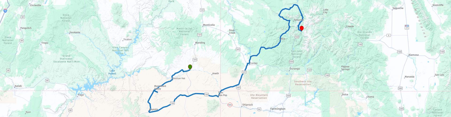
Day 07 Bluff to Silverton via Monument Valley and the San Juan Skyway

This route was brought to you by:
RouteXpert Paul Hedges - Adv RouteXpert
Last edit: 01-02-2022
 Route Summary
 This is a day where the scenic experience makes it a 4 star day alone.
 Share this route


Animation

Verdict


Duration
9h 43m

Mode of travel
Car or motorcycle

Distance
539.96 km

Countries

 RouteXpert Review
 As ever start the day with a full fuel tank.
Today will be a day marked down for scenic overload. The day starts by travelling to one of America's most iconic skylines, Monument Valley. The back drop to countless Western Films and modern blockbusters too. Stop at Forrest Gump Point (RP6) where, after running for more than three years Forrest Gump suddenly stops and says “I'm pretty tired… I think I'll go home now.”
Turning off the main road through and heading towards The View hotel you can take the opportunity to get your own widescreen technicolour landscape photograph at Monument Valley View (RP12)
Your journey through the Valley also includes crossing the Utah/Arizona Border (RP14)
If you were up early to take a sunrise picture at The View then it will be soon be time for a break at The Amigo Cafe (RP17) before you head East along the highway.
Take time to stop at Teen Nos Pos Trading Point, an old fashioned trading post, was established on the Navajo Nation in 1905. It has faithfully maintained the old fashioned trading post traditions initiated by the Noel and Foutz families. It is also the first fuel stop of the day (RP23) Once you have refuelled and topped up on liquid yourself it is time to head North towards the Arizona / New Mexico State Line (RP24) and then soon after the New Mexico/Colorado Border(RP25)
As you arrive in Dolores (RP33) you start your trip on the San Juan Skyway. The San Juan Skyway is one of the most scenic drives in America, spanning elevations from 6,200 feet near Cortez to 11,008 feet at Red Mountain Pass.
There are pull offs along the way to take in the peaks in the San Juan Mountains. Lizard Head (RP37) Sunshine Mountain(RP39) or the 5 peaks of the Sneffel Range (RP43)
From Ridgway you head south through Ouray, remembering to stop at the Switzerland of America Lookout Point (RP47) and look down the canyon to see why the name has been given. Then take a break at the stunning Great Bear falls (48) before heading onto the part of the Skyway called The Million Dollar Highway. Built between 1880 and 1920, the old toll road served as a mail, stage, and freight route. Even though you will be bathed in stunning scenery keep your eyes on the road along this stretch of the San Juan Skyway. It’s narrow (only two lanes wide) and threads around hairpin turns, and even with the height, there are no guard rails.
As you travel to the peak at Red Mountain Pass (RP52) to an elevation of 11,018 feet the views reward you with breath taking views from the top. This is avalanche country and at periods through the year the roads can close very quickly. It is advised to always check the weather and be prepared for anything when traversing Red Mountain Pass.
The day ends on arrival in Silverton, according to local lore, the town was named by a miner who once exclaimed, 'We may not have gold here, but we have silver by the ton' This mining town has many Victorian buildings registered as National Historical Sites, most older than in other towns along this route simply because it has not suffered the misfortune of fire, possibly because of its annual 300-inches of snow.
This is really one of those days where it might take a day or two to process everything that has been seen. The day started in Bluff, Utah with it's barren surroundings and ended 7000 feet higher in altitude passing through the 1.8 million acre San Juan National Forest. So make sure you plenty of cameras and plenty of storage to get through this day


 Links
Links  Usage
Usage Want to download this route?
You can download the route for free without MyRoute-app account. To do so, open the route and click 'save as'. Want to edit this route?
No problem, start by opening the route. Follow the tutorial and create your personal MyRoute-app account. After registration, your trial starts automatically.  Disclaimer
Use of this GPS route is at your own expense and risk. The route has been carefully composed and checked by a MyRoute-app accredited RouteXpert for use on TomTom, Garmin and MyRoute-app Navigation.
Changes may nevertheless have occurred due to changed circumstances, road diversions or seasonal closures. We therefore recommend checking each route before use.
Preferably use the route track in your navigation system. More information about the use of MyRoute-app can be found on the website under 'Community' or 'Academy'.
.jpg/800px-Grand_Canyon_Horseshoe_Bend_(crop_2).jpg)
Arizona
About this region
Arizona (AIR-iz-OH-nə; Navajo: Hoozdo Hahoodzo Navajo pronunciation: [hoː˥z̥to˩ ha˩hoː˩tso˩]; O'odham: Alĭ ṣonak) is a state in the Western United States, grouped in the Southwestern and occasionally Mountain subregions. It is the 6th largest and the 14th most populous of the 50 states. Its capital and largest city is Phoenix. Arizona shares the Four Corners region with Utah to the north, Colorado to the northeast, and New Mexico to the east; its other neighboring states are Nevada and California to the west and the Mexican states of Sonora and Baja California to the south and southwest.
Arizona is the 48th state and last of the contiguous states to be admitted to the Union, achieving statehood on February 14, 1912. Historically part of the territory of Alta California in New Spain, it became part of independent Mexico in 1821. After being defeated in the Mexican–American War, Mexico ceded much of this territory to the United States in 1848. The southernmost portion of the state was acquired in 1853 through the Gadsden Purchase.
Southern Arizona is known for its desert climate, with very hot summers and mild winters. Northern Arizona features forests of pine, Douglas fir, and spruce trees; the Colorado Plateau; mountain ranges (such as the San Francisco Mountains); as well as large, deep canyons, with much more moderate summer temperatures and significant winter snowfalls. There are ski resorts in the areas of Flagstaff, Alpine, and Tucson. In addition to the internationally known Grand Canyon National Park, which is one of the world's seven natural wonders, there are several national forests, national parks, and national monuments.
Since the 1950s, Arizona's population and economy have grown dramatically because of migration into the state, and now the state is a major hub of the Sun Belt. Cities such as Phoenix and Tucson have developed large, sprawling suburban areas. Many large companies, such as PetSmart and Circle K, have headquarters in the state, and Arizona is home to major universities, including the University of Arizona and Arizona State University. Traditionally, the state is politically known for national conservative figures such as Barry Goldwater and John McCain, though it voted Democratic in the 1996 presidential race and in the 2020 presidential and senatorial elections.
Arizona is home to a diverse population. About one-quarter of the state is made up of Indian reservations that serve as the home of 27 federally recognized Native American tribes, including the Navajo Nation, the largest in the state and the United States, with more than 300,000 citizens. Since the 1980s, the proportion of Hispanics in the state's population has grown significantly owing to migration from Mexico. In terms of religion, a substantial portion of the population are followers of the Catholic Church and The Church of Jesus Christ of Latter-day Saints (Mormon).
Read more on Wikipedia
Arizona is the 48th state and last of the contiguous states to be admitted to the Union, achieving statehood on February 14, 1912. Historically part of the territory of Alta California in New Spain, it became part of independent Mexico in 1821. After being defeated in the Mexican–American War, Mexico ceded much of this territory to the United States in 1848. The southernmost portion of the state was acquired in 1853 through the Gadsden Purchase.
Southern Arizona is known for its desert climate, with very hot summers and mild winters. Northern Arizona features forests of pine, Douglas fir, and spruce trees; the Colorado Plateau; mountain ranges (such as the San Francisco Mountains); as well as large, deep canyons, with much more moderate summer temperatures and significant winter snowfalls. There are ski resorts in the areas of Flagstaff, Alpine, and Tucson. In addition to the internationally known Grand Canyon National Park, which is one of the world's seven natural wonders, there are several national forests, national parks, and national monuments.
Since the 1950s, Arizona's population and economy have grown dramatically because of migration into the state, and now the state is a major hub of the Sun Belt. Cities such as Phoenix and Tucson have developed large, sprawling suburban areas. Many large companies, such as PetSmart and Circle K, have headquarters in the state, and Arizona is home to major universities, including the University of Arizona and Arizona State University. Traditionally, the state is politically known for national conservative figures such as Barry Goldwater and John McCain, though it voted Democratic in the 1996 presidential race and in the 2020 presidential and senatorial elections.
Arizona is home to a diverse population. About one-quarter of the state is made up of Indian reservations that serve as the home of 27 federally recognized Native American tribes, including the Navajo Nation, the largest in the state and the United States, with more than 300,000 citizens. Since the 1980s, the proportion of Hispanics in the state's population has grown significantly owing to migration from Mexico. In terms of religion, a substantial portion of the population are followers of the Catholic Church and The Church of Jesus Christ of Latter-day Saints (Mormon).
View region
 Statistics
  20
20Amount of RX reviews (Arizona)
 25267
25267Amount of visitors (Arizona)
 531
531Amount of downloads (Arizona)
 Route Collections in this region
 Car or motorcycle tour through the western US
This collection contains all 15 routes driven by MRA Goldmember André ter Schegget during his three-week tour through the west of America.
The places to visit, the attractions and beautiful photo spots are nicely marked on the routes. The routes have been fully checked and made equal for the Garmin and the TomTom. Enjoy this wonderful trip and let us know how it was! Enjoy and stay safe!
Order of the tour:
Route 01: from Los Angeles and via Pacific Coast Highway to Solvang
Route 02: Solvang to Monterey / Pacific Grove
Route 03A: Monterey to San Francisco
Route 03B: if you are by car instead of the motorcycle, as motorcycles are not allowed on the 17 Mile Drive: from Monterey to the 17 Mile Drive and further to San Francisco
Route 04: from San Francisco via Nappa and Eldorado National Forrest to Topaz Lake
Route 05: from Topaz Lake via Bodie and Yosemite to Oakhurst
Route 06: from Oakhurst via Kings Canyon NP and Sequoia NP and Giant Forest to Exeter
Route 07: Exeter via Isabella Lake and Ridgecrest to Death Valley
Route 08: from Death Valley via Valley Of Fire to Mesquite
Route 09: from Mesquite via Zion NP and Dixie NF to Hatch
Route 10: Hatch via Bryce Canyon to Page
Route 11: from Page via Grand Canyon to Williams
Route 12: from Williams via Seligman and Route 66 to Kingman and via Hoover Dam to Las Vegas
Route 13: from Las Vegas via Oatman and Lake Havasu to Parker
Route 14: from Parker via Joshua Tree to Rancho Mirage
Route 15: Rancho Mirage via Palm Springs to Santa Monica
View Route Collection
Top car and motorcycle tour through the west of the USA
By car or motorcycle through the West of America is a journey that you do not just make, so also not driving 15 days and then back home. No, book a stay of several days in Los Angeles, Las Vegas, San Francisco and again Los Angeles to also visit several places of interest in these cities, so that this tour becomes an unforgettable tour that you can remember with pleasure.
Do not forget to arrange and pack the following items:
*This is only a summary and completely personal and may differ per person.
Take out travel insurance, +31 for numbers in GSM, (partially) take out gas, Health insurance coverage at destination?, Switch off electrical appliances, Lighting (time clock), Check passport validity, Antenna from radio/TV due to lightning, Residence address for those left behind, Remote control house alarm, Book Smart Parking.
Hand luggage:
Liquids in packaging of max. 100 ml, Liquids in hand luggage in transparent plastic bag.
For on the road:
Candy, Book, Earplugs, Country and road map(s), Directions, Maps in your navigation system
Money & Securities:
Bank card / giro card, Credit card (think pin code), Cash, Calculator for Internet banking, Medical insurance card, Travel insurance card.
Travel documents:
Passport, (International) Driver's License, Ticket(s), Reservation Tickets, Hotel Vouchers, Arrival/Departure Time, Check-in & Check-out Times, Valid Visa (ESTA), Travel Guide.
Clothing:
Underwear, Belt, Shirts/ T-shirts, Shorts, Long pants, Shoes, Socks, Swim trunks, Towel, Slippers.
Personal stuff:
Watch, House Keys, Wallet, Sunglasses.
Toiletries:
Deodorant, Shower gel / Soap, Comb / brush, Shaving equipment, Shampoo, Toothbrush, Toothpaste, Sanitary pads
Health & Medicine:
Own medicines, Insect repellent, Cold sore ointment, Ointment for insect bites, Sunscreen, Norit, Paracetamol, Suction cup for insect bites, First aid bag.
Miscellaneous:
Travel bag / waist bag, Leatherman (= checked luggage), Pen or pencil, Headlamp, Lighter, Tools & Electronics, Mobile phone & charger, Photo/video camera & charger, Memory card(s), World plug / adapter, Ipod & charger, Adapter cable Ipod, Headphones, iPad & charger, Navigation & charger/plug, Plug socket, Fuelpack battery.
Engine (accessories):
Helmet, Motorcycle clothing, Motorcycle boots, Chain lock / disc brake lock, Gloves, Bandana, Inner bags (plastic shopping bag), Insulation bag, Tension straps, Tie wraps, Rain suit, Rainaway.
Addresses:
Address list, Embassy telephone number, Telephone number to block (bank) card(s), Telephone number (airline tickets).
View Route Collection