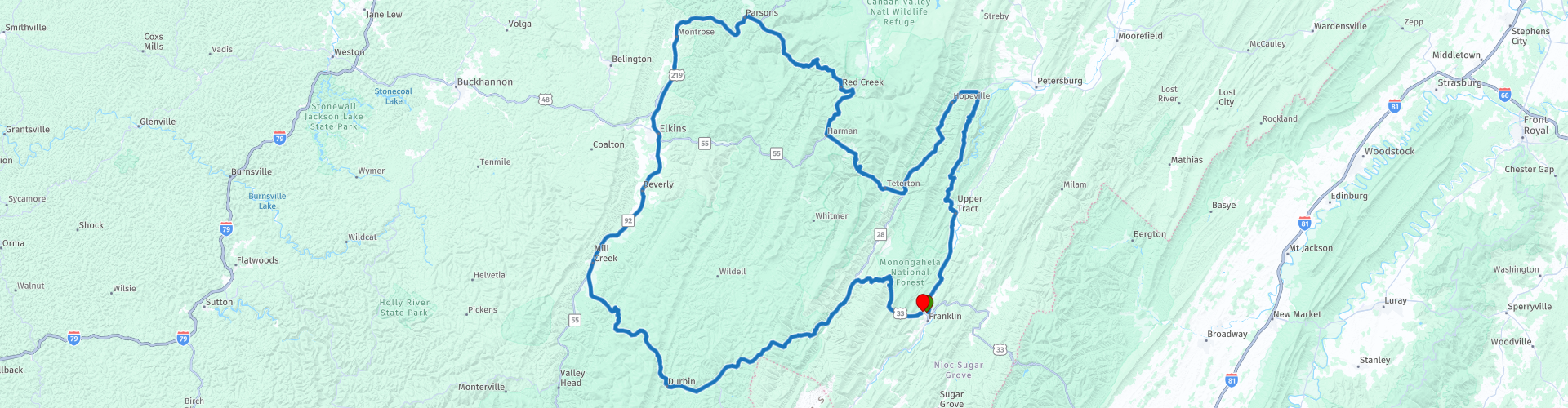
Round trip from Franklin via Seneca Rocks and Elkins

This route was brought to you by:
RouteXpert Nick Carthew - (MRA Master)
Last edit: 29-12-2023
 Route Summary
  Share this route


Animation

Verdict


Duration
6h 40m

Mode of travel
Car or motorcycle

Distance
291.94 km

Countries

 RouteXpert Review
 The route follows the South Branch Potomac River to the hamlet of Upper Tract, here you'll take a left onto Smoke Hole Road.
Smoke Hole Road is a popular motorcycle route following the South Branch Potomac River along a rugged rocky canyon in the Spruce Knob - Seneca Rocks National Recreation Area. There are lots of twists and turns and elevation changes on this 17 mile, two way country road as you make your way to the North Fork South Branch Potomac River.
You'll find Smoke Hole Caverns a short distance from crossing over the North Fork South Branch Potomac River. Here you can take a 45 minute guided tour for $17.00. The history of Smoke Hole Caverns is tied to the Seneca Indians who used the front section of the caverns to smoke wild game. The slow-burning wood fires sent clouds of smoke swirling out into the valley. The scene was so common that early settlers called the place Smoke Hole. The many rooms and secluded nature of the Caverns were also the ideal place for early settlers and immigrants to make corn whiskey after the Civil War. The clean cold stream that flows through the Caverns was perfect for “moonshine” and it is estimated that perhaps as many as 20 stills operated at one time!! An original still remains on display today complete with its story.
Follow the course of the North Fork South Branch Potomac River for 13 miles to Seneca Rocks.
Seneca Rocks is a large crag and local landmark and one of the best known scenic attractions in West Virginia, the almost vertical cliff attract rock climbers from all over the world. Seneca Rocks are located near the confluence of Seneca Creek and the North Fork South Branch Potomac River. The village has several rock climbing operations that offer guiding and rock climbing courses. Both the village and the famous rock are part of the Spruce Knob-Seneca Rocks National Recreation Area within the Monongahela National Forest. Seneca Rocks is the location of the historic Sites Homestead built in 1839, as well as the Seneca Rocks Visitor Centre.
I have suggested a coffee stop at Yokum’s Store, a family run business since 1923. Next door to Yokum’s is another historic family run business; Harper's Old Country Store was built back in the year 1902 and has served as a general country store for many generations and to this day is still run by the Harper family. Many antiques and old features can be seen inside Harper's Old Country Store, so the interior looks much like it did when it originally opened.
The route now follows the path of Seneca Creek on the WV55 at Harmon you take the right fork WV32 North heading for Davis. As you leave the town of Harmon, you can stop at the Day-Vandevander Mill, also known as the Old Mill at Harman. This is a historic grist mill. The original structure was built about 1877, and is a morticed and tenon, hand hewn post and beam structure. The property includes the original mill pond and tail race. It is open as a mill museum where you can learn about and watch the milling process; you can even buy some freshly milled flour. The mill derives its power from two water turbines, using the water from the Dry Fork of the Cheat River in a very picturesque setting.
Just after crossing Red Creek the route takes the WV72 Dry Creek Road. This is a very narrow and twisty road with lots of elevation changes. A caution road sign can be seen at the beginning of the road warning of narrow road and sharp curves for the next 15 miles. Take note of the warning but enjoy the next 15 miles of this exhilarating road.
The next stop is for lunch in the quaint city of Elkins.
Elkins in West Virginia embodies what a mountain oasis looks like. There are numerous first class eateries to choose from including all of the fast-food outlets. This mountain city on the tip of the Monongahela National Forest boasts a vibrant culture of arts and tradition vividly seen in its art galleries. The city has a long history of railroads and logging, but the community has preserved the beauty of its natural surroundings.
The first half of the return route after lunch is in a more open landscape with fewer twists and turns using the US250. At Huttonsville, the twists, turns and elevation changes return as you get closer to the Allegheny Mountains again.
The town of Durbin is a town that railroads built, left behind & is now slowly being resurrected again by the love of old railways. The need to move timber out of the mountains & workers into the area motivated the building of the railroad. The Chesapeake & Ohio brought the first passengers in 1902. The next year, the Western Maryland reached south from Elkins, making Durbin a railroad junction for freight & passengers. Today you can take a ride on the steam powered Durbin Rocket on its 2 hr, 5.5 mile beautiful scenic run along the Greenbrier River. or maybe just stop for a relaxing coffee.
A few miles out of Durnin the route takes you further into the mountains and you'll reach the highest point of the route, 1200 m or 3937 ft above sea level.
Next comes Germany Valley Overlook.
Germany Valley is one of the most picturesque locations in the state. Known for its extensive cave system, with dozens of caves documented, it was designated a National Natural Landmark in 1973 by the National Park Service. This 10-mile-long valley is named for the German families who first settled here. German language, culture, and folklore have persisted well into the late 20th century in parts of Pendleton County. Germany Valley, despite its name and the German ancestry of many of its residents, generally is not considered one of those places.
At the overlook you will also see an historical marker stating: In Germany Valley is the site of Hinkle's Fort built in 1761–1762. It was the only defence of the South Branch after Fort Upper Tract and Fort Seybert were destroyed by Shawnee Indians under Killbuck, April 27–28, 1758.
From this magnificent outlook, it is just a 10 minute ride back into Franklin.
Enjoy.


 Links
Links  Usage
Usage Want to download this route?
You can download the route for free without MyRoute-app account. To do so, open the route and click 'save as'. Want to edit this route?
No problem, start by opening the route. Follow the tutorial and create your personal MyRoute-app account. After registration, your trial starts automatically.  Disclaimer
Use of this GPS route is at your own expense and risk. The route has been carefully composed and checked by a MyRoute-app accredited RouteXpert for use on TomTom, Garmin and MyRoute-app Navigation.
Changes may nevertheless have occurred due to changed circumstances, road diversions or seasonal closures. We therefore recommend checking each route before use.
Preferably use the route track in your navigation system. More information about the use of MyRoute-app can be found on the website under 'Community' or 'Academy'.

West Virginia
About this region
West Virginia is a state in the Appalachian, Mid-Atlantic and Southeastern regions of the United States. It is bordered by Pennsylvania to the northeast, Maryland to the east and northeast, Virginia to the southeast, Kentucky to the southwest, and Ohio to the northwest. West Virginia is the 41st-largest state by area and ranks 40th in population, with a population of 1,793,716 residents. The capital and largest city is Charleston.
West Virginia became a state after the Wheeling Conventions of 1861, at the start of the American Civil War. Delegates from northwestern Virginia's Unionist counties decided to break away from Virginia, which also included secessionist counties in the new state. West Virginia was admitted to the Union on June 20, 1863, and was a key border state during the war. It was the only state to form by separating from a Confederate state, the second to separate from a state after Maine separated from Massachusetts, and one of two states (along with Nevada) admitted to the Union during the Civil War. Some of its residents held slaves, but most were yeoman farmers, and the delegates provided for the gradual abolition of slavery in the new state constitution. The state legislature abolished slavery in the state, and at the same time ratified the 13th Amendment abolishing slavery nationally on February 3, 1865.
West Virginia's Northern Panhandle extends adjacent to Pennsylvania and Ohio to form a tristate area, with Wheeling and Weirton just across the border from the Pittsburgh metropolitan area. Huntington in the southwest is close to Ohio and Kentucky, while Martinsburg and Harpers Ferry in the Eastern Panhandle region are considered part of the Washington metropolitan area, between Maryland and Virginia. West Virginia is often included in several U.S. geographical regions, including the Mid-Atlantic, the Upland South, and the Southeastern United States. It is the only state entirely within the area served by the Appalachian Regional Commission; the area is commonly defined as "Appalachia".The state is noted for its mountains and rolling hills, its historically significant coal mining and logging industries, and its political and labor history. It is also known for a wide range of outdoor recreational opportunities, including skiing, whitewater rafting, fishing, hiking, backpacking, mountain biking, rock climbing, and hunting.
Other nominated names for the state included Vandalia, Kanawha, Appalachia, and Western Virginia. The capital was originally Wheeling, before switching to Charleston, moving back to Wheeling, and finally back to Charleston. While it is now a solidly Republican state, it was Democratic from the Franklin D. Roosevelt era to the 1990s. The first governor was Arthur Boreman.
Read more on Wikipedia
West Virginia became a state after the Wheeling Conventions of 1861, at the start of the American Civil War. Delegates from northwestern Virginia's Unionist counties decided to break away from Virginia, which also included secessionist counties in the new state. West Virginia was admitted to the Union on June 20, 1863, and was a key border state during the war. It was the only state to form by separating from a Confederate state, the second to separate from a state after Maine separated from Massachusetts, and one of two states (along with Nevada) admitted to the Union during the Civil War. Some of its residents held slaves, but most were yeoman farmers, and the delegates provided for the gradual abolition of slavery in the new state constitution. The state legislature abolished slavery in the state, and at the same time ratified the 13th Amendment abolishing slavery nationally on February 3, 1865.
West Virginia's Northern Panhandle extends adjacent to Pennsylvania and Ohio to form a tristate area, with Wheeling and Weirton just across the border from the Pittsburgh metropolitan area. Huntington in the southwest is close to Ohio and Kentucky, while Martinsburg and Harpers Ferry in the Eastern Panhandle region are considered part of the Washington metropolitan area, between Maryland and Virginia. West Virginia is often included in several U.S. geographical regions, including the Mid-Atlantic, the Upland South, and the Southeastern United States. It is the only state entirely within the area served by the Appalachian Regional Commission; the area is commonly defined as "Appalachia".The state is noted for its mountains and rolling hills, its historically significant coal mining and logging industries, and its political and labor history. It is also known for a wide range of outdoor recreational opportunities, including skiing, whitewater rafting, fishing, hiking, backpacking, mountain biking, rock climbing, and hunting.
Other nominated names for the state included Vandalia, Kanawha, Appalachia, and Western Virginia. The capital was originally Wheeling, before switching to Charleston, moving back to Wheeling, and finally back to Charleston. While it is now a solidly Republican state, it was Democratic from the Franklin D. Roosevelt era to the 1990s. The first governor was Arthur Boreman.
View region
 Statistics
  5
5Amount of RX reviews (West Virginia)
 379
379Amount of visitors (West Virginia)
 33
33Amount of downloads (West Virginia)
 Route Collections in this region
 Ultimate USA road trip part 05
Michel van Hagen challenged me to follow the Roadtrip of Dr. Randy Olsen as a basis to create the Ultimate USA Road Trip for the MyRoute app RouteXpert Library. I took up that challenge and started in February 2022.
The scientist Dr. Randy Olsen, who became known for using his knowledge of algorithms to find 'Waldo' in the well-known American 'Where's Waldo' book series, has been challenged by Tracy Staedter, from Discovery News, to use the same algorithm to create the perfect Road Trip by creating the US, which will visit almost every state in the US. Alaska and Hawaii are not included in this Road Trip due to their geographical location.
The following three requirements formed the basis of the route: In all 48 countries there must be at least one stop at famous points, monuments, historical sites, national parks, etc. I have added additional interesting points, beautiful tours and routes.
After more than 26 months, the job is finished and, with a lot of support from Nick Carthew, I have created 129 routes that run through the 48 states of the USA and part of Canada. This is the fifth collection that takes you from Cocao Beach in ten days through Florida, Georgia, South Carolina and Virginia to Kill Devil Hills in North Carolina.
View Route Collection