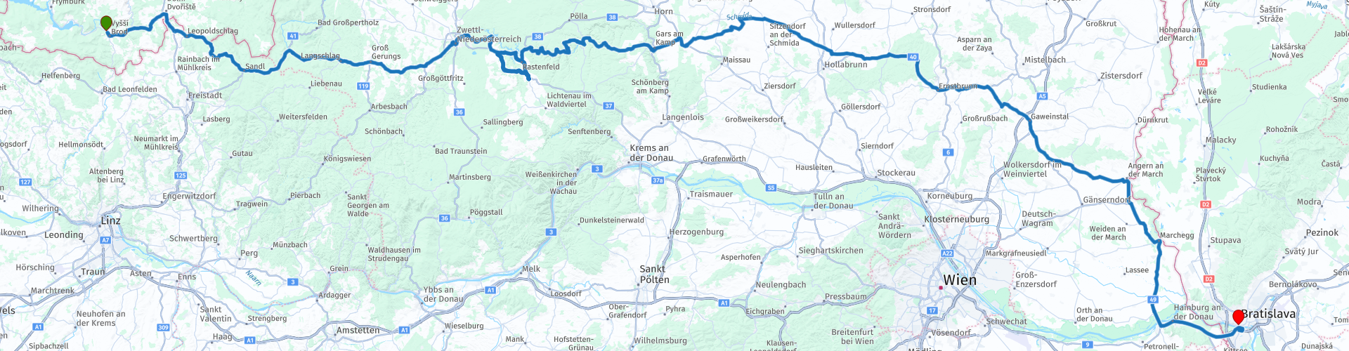
Day 04 Silk Road Vyssi Brod Bratislava

This route was brought to you by:
RouteXpert René Plücken (MRA Master)
Last edit: 05-11-2021
 Route Summary
 This day we drive largely through beautiful Austria with beautiful roads, mountains, valleys and castles.
We drive on provincial roads interspersed with beautiful winding country roads. The roads are asphalted and of very good quality.
The landscape is beautifully green, interspersed with reservoirs and beautiful old villages.
This route is rated with 4 stars because of the beautiful winding roads through the beautiful nature and villages with nice sights, such as castles and museums.
 Share this route


Animation

Verdict


Duration
13h 50m

Mode of travel
Car or motorcycle

Distance
307.54 km

Countries


 RouteXpert Review
 Some possible stops are;
The Postal Museum located in the Cistercian Monastery in Vyšší Brod. Here you can take a tour of an area of almost 2,000 m2 of postal service exhibits. It displays authentic exhibits, such as postal uniforms, post office signs, letter boxes, cash boxes and telecommunications equipment, which are used to document daily postal operations. A unique collection of stagecoaches and sleighs charts the history of postal transport.
The Hafnerhaus in Leopoldschlag, a ceramics museum where beautiful pottery ceramics, such as bowls, jugs, vases, cups are still produced. These items are very popular as gifts and souvenirs and for sale during the museum's opening hours.
"The Rushing Rock" between Mairspindt and Hammern. This rock, called "Der Rauschende Felsen von Windhaag" in German, is an extraordinary natural phenomenon. The sound of the water masses of the Maltsch is best heard when you stand directly at the rock. One possible reason for this "phenomenon" is that the murmur of the Maltsch is reverberated by the opposing rock faces on the Czech side.
The Railway Museum in Langschlag is a museum in a wagon on rails. In the museum car you will get to know the origin of the Waldviertelbahn with tunnel construction from Gmünd to Groß Gerungs. Showcases, old uniforms, cash register equipment and tools from track construction are displayed here. Within walking distance is the Kaufmanns- en Bier museum founded in 1989 on the occasion of the 100th anniversary of the Fraberger department store. There is an abundance of old billboards, some from 1920. Also special are the machines of the 1st Waldviertel shoe wax production and the "Germschneider". There is an exhibition of more than 3000 bottles, cans and coasters from all over the world.
The "Hoar- und Weberstub'n" museum of the Friedrich and Erika Ertl family, where the visitor can experience all the work processes, from flax processing, winding, tailoring and construction of the warp to the actual weaving process. There is also the possibility for visitors and school classes to weave their own carpet.
The city museum of Zwettl in the old city hall with a wide range of topics such as: the city history of Zwettler, work of the Kuenringer, exhibition of newly restored gold, fork and bridal hats, Anton collection and regularly changing special exhibitions. This city also offers the opportunity for a longer break with a delicious cup of coffee and pastries in one of the coffee-pastry shops.
An absolute must is the Stift Zwettl Abbey! Founded in 1138 by Hadmar I. van Künring, this monastery has retained its medieval appearance to this day. The monastery was built in the first half of the 13th century. You can follow the different stages of medieval architecture here, if you look at the oldest parts, the northern and the eastern wings, you can see the round Romanesque arches, in the fountain house there are lanceolate-gothic arches.
Near the dormitory, where the monks slept, is the "necessarium", the latrine. The Romanesque-style chapter house dates from the last quarter of the 12th century. It is thus the oldest surviving Cistercian chapter. The monastery church has a late Gothic hall choir that harmoniously combines with an ambulatory and a ring of 14 chapels, the Baroque main altar is dedicated to the Assumption of the Virgin Mary.
Near the monastery there are two restaurants for the lunch break.
Another highlight is a visit to the ruins of Lichtenfels Castle. From the hill on which the castle stands you have a beautiful view of the Ottensteiner Reservoir. Ottenstein is the furthest upstream and also the largest of the three reservoirs along the Kamp River.
It offers landscapes of striking beauty and numerous popular recreational activities. The deep coves along the lake shore are reminiscent of Scandinavian fjords, a landform that isn't exactly Austrian. They are part of the special charm of this region around the Ottenstein reservoir.
In the craft museum “am Berg” in St Leonhard you can experience the old craft techniques and rural life! In the handicraft demonstrations, craftsmen show how people used to make everyday products with simple tools. Demonstrations include blacksmithing, tailoring, cobbling, weaving, woodworking, knot turning and bobbin lace.
Farm work such as felling scythes, covering straw and threshing can also be seen. The typical women's areas of that time, such as laundry, kitchenware, spinning and bread baking, are also shown. So-called “burn marks” can be tasted on the demonstration Sundays in the simulated oven!
In Zogelsdorf, in the Steinmetzmuseum, the stonemason's house, you can see how the sandstone was extracted and processed. The tools and techniques are discussed and explained in the museum and in the Johannes Schausteinbruch.
You can also visit the Zogelsdorf castle here, which dates from the 16th and 17th centuries. From 1522, the former mansion was owned by noble families. In 1831 it was used as an inn. Today the castle is owned by the Perko-Greiffenbühl family. In 2009, a museum of religious order was established in several rooms, which is managed by the IOU Society for Religious Studies, Heraldry and Family Research. Various decorations, awards and medals are on display.
Marchegg Castle is a Baroque castle in Marchegg in Lower Austria. As one of the five Marchfeld castles, it was chosen as an exhibition location for the Lower Austrian State Exhibition in 2022. To this end, the castle is being completely revived and restored. The castle in Marchegg was built by King Ottokar II of Bohemia as a moated castle and was part of the Marchegg town fortifications. The first written mention of this castle dates from the year 1268. Almost 400 years later, the moat was filled in, the corner bastion removed and the castle converted into a Baroque palace. In the following two centuries, the castle was mainly a hunting lodge and summer residence of the Hungarian royal family Pálffy ab Erdöd. The former hunting ground around the castle has been designated a nature reserve for 40 years and is managed by the WWF.
The last stop before checking into our hotel in Bratislava is a visit to the UFO bridge a must. The view over the city is fantastic.
Bratislava is a beautiful city with a lot of culture and definitely worth a longer visit.


 Links
Links  Usage
Usage Want to download this route?
You can download the route for free without MyRoute-app account. To do so, open the route and click 'save as'. Want to edit this route?
No problem, start by opening the route. Follow the tutorial and create your personal MyRoute-app account. After registration, your trial starts automatically.  Disclaimer
Use of this GPS route is at your own expense and risk. The route has been carefully composed and checked by a MyRoute-app accredited RouteXpert for use on TomTom, Garmin and MyRoute-app Navigation.
Changes may nevertheless have occurred due to changed circumstances, road diversions or seasonal closures. We therefore recommend checking each route before use.
Preferably use the route track in your navigation system. More information about the use of MyRoute-app can be found on the website under 'Community' or 'Academy'.

Lower Austria
About this region
Lower Austria (German: Niederösterreich; Austro-Bavarian: Niedaöstareich, Niedaestareich) is one of the nine states of Austria, located in the northeastern corner of the country. Since 1986, the capital of Lower Austria has been Sankt Pölten, replacing Vienna which became a separate state in 1921. With a land area of 19,186 km2 (7,408 sq mi) and a population of 1.685 million people, Lower Austria is the second most populous federal state (after Vienna). Other large cities are Amstetten, Klosterneuburg, Krems an der Donau and Wiener Neustadt.
Read more on Wikipedia
View region
 Statistics
  4
4Amount of RX reviews (Lower Austria)
 11042
11042Amount of visitors (Lower Austria)
 509
509Amount of downloads (Lower Austria)
 Route Collections in this region
 The 24 Most Beautiful Alpine Routes
The Alps, The Alps are a mountain range in Europe, stretching from the French Mediterranean coast in the southwest to the Pannonian Plain in the east. The area of the mountain range is more than 200,000 km².
In other words Passes and Mountain Roads!
Driving through the mountains is great! Especially over the mountain passes with hairpin bends and narrow winding roads. Every bend a different view where you can enjoy. There are many beautiful mountain passes in the Alps.
A selection that has also been incorporated into these routes:
The Stlevio Pass:
The Stelvio Pass, also known as Passo dello Stelvio, is mainly known for the stage in the Giro d'Italia. Due to the length and the difference in height, this pass is seen as one of the toughest tests in cycling. The Stelvio Pass reaches a maximum height of 2758 meters and is therefore one of the highest in the Alps. The pass connects the towns of Bormio and Prato Allo Stelvio. In winter the pass is closed due to heavy snowfall.
The Reschenpass:
The Reschenpass, also known as Passo di Resia, connects the Austrian state of Tyrol with the Italian province of South Tyrol. The pass reaches a maximum height of 1,504 meters and has been one of the most important north-south connections in the Alps in recent centuries. The pass was used long before Roman times. Along the way you will pass several highlights and historical relics. One of the highlights is the Reschensee. This lake was created after the construction of the dam and has completely submerged the village of Graun. The only thing that reminds of that is the clock tower in the middle of the lake.
Col du Galibier:
The French mountain pass Col du Galibier connects the towns of Saint-Michel-de-Maurienne and Briançon via the Col du Lautaret in the south and the Col du Télégraphe in the north. The mountain pass is part of the Tour de France and very much feared, due to the fact that it can only be reached via the other two mountain passes. The pass reaches a maximum height of 2646 meters. From there you can take a walk to the viewpoint at 2704 meters. You can admire the peaks of the Grand Galibier, Mont Blanc and La Meije here.
The Grossglockner High Alpine Road:
With a height of 3798 meters the Grossglockner is the highest mountain in Austria. To fully enjoy this impressive mountain, you can drive over the Grossglockner High Alpine Road and the accompanying pass. The route starts from Bruck am Grossglockner and ends in Heiligenblut. Of course you can drive in two directions. The pass reaches a maximum height of 2504 meters and is closed in winter due to heavy snowfall. Along the way you pass several stops with fun activities, information points, mountain huts and viewpoints. A visit to the Kaiser-Franz-Josefs-Höhe and Pasterzen Glacier is highly recommended.
The Col d'Izoard:
Just like the Col du Galibier, the Col d'Izoard is also part of a stage of the Tour de France. The mountain pass connects Briançon with the valley of the river Guil. The pass is partly located in the Regional Natural Park du Queyras and reaches a maximum height of 2360 meters. What is special about the Col d'Izoard is the barren and rocky landscape. Sometimes it feels like driving a car over the moon! Along the way you can stop at several points to enjoy the beautiful view.
The Bernina Pass:
The Bernina Express is one of the most famous rail trains in Switzerland and the Alps. The route is beautiful and partly included on the UNESCO World Heritage List. Parallel to the railway lies the Bernina pass, which connects the Veltlin valley with the Egandin valley. This beautiful Alpine road has a total length of 56 kilometers and reaches a maximum height of 2328 meters. Along the way you can enjoy views of the Morteratsch Glacier.
The Sella Pass:
The Sella Pass, also known as Passo di Sella, takes you over one of the most impressive mountain ranges in the Dolomites: the Sella massif. The pass connects Valle di Fassa with Val Gardena and reaches a maximum height of 2236 meters. At this height is also the border of the Italian provinces of Trentino and Bolzano. Along the way you can enjoy the view of this spectacular mountain world. Admire, for example, the three peaks of the Sasso Lungo massif, the Sella massif or the peaks of the Marmolada. You can also drive the Sella pass in combination with the Gardena pass, Pordoi pass and Campolongo pass.
The Grimsel Pass:
The Grimsel Pass connects Goms in Wallis with the Halis Valley in the Bernese Oberland. The pass reaches a maximum elevation of 2165 meters and is closed in winter due to snowfall. Over the centuries, the mountain pass has played an important role in trade between Switzerland and Italy. Now it is mainly the reservoirs that have an important function. These are used to generate electricity. The landscape you drive through is rugged, rocky and impressive. On top of the pass is a hotel and a restaurant with a special marmot park. The Dodensee (Totensee) is also located here. This lake owes its name to the many soldiers who died in the time of Napoleon.
The Gotthard Pass:
The Gotthard Pass, also known as Passo del San Gottardo and Saint Gotthard, connects the Swiss towns of Airolo and Andermatt. The mountain pass and associated tunnel are especially known among holidaymakers driving from Switzerland to Italy. But where the majority opt for the tunnel, it is precisely the pass that really completes the holiday. The Gotthard Pass has a length of about 26 kilometers and reaches a maximum height of 2106 meters. The route is beautiful and takes you along old villages and beautiful views.
The Silvretta High Alpine Road and Silvretta Pass:
The Paznaun Valley in Tyrol and the Montafon in Vorarlberg are connected by the Silvretta High Alpine Road. The route has a length of 22.3 kilometers and leads from Galtür to Partenen in 34 hairpin bends, via the 2032 meter high Bielerhöhe. The Silvrettasee is also located at this point, where you can enjoy a lovely walk. The pass is closed in winter due to snowfall.
The Simplon Pass:
Just like the Gotthard Pass, many holidaymakers also travel over the Simplon Pass every year. This mountain pass connects the Rhone Valley in the canton of Valais with the Valle d'Ossola in Piemonte. The pass is open all year round and reaches a maximum height of 2005 meters. Along the way you pass a number of buildings, including the well-known Simplon Hospiz from 1825. The hospiz is managed by the monks of St. Bernard. From the highest point on the pass, all kinds of hiking routes are possible and you will also come across a hotel where you can spend the night.
The Gerlos Pass:
The Gerlos Pass connects the Salzach Valley in the Salzburgerland with the Zillertal Valley in Tyrol. The pass is part of the Gerlos Alpenstraße and runs right through the Hohe Tauern National Park. Along the way you can enjoy beautiful views of the surroundings. The pass has a length of 12 kilometers and reaches a maximum height of 1531 meters. A ride over the Gerlos Pass can be ideally combined with a visit to the Krimmler Wasserfälle.
The Great St. Bernard Pass:
The Great St. Bernard Pass, better known as Col du Grand Saint Bernard, connects the Italian province of Valle d'Aosta with the Swiss canton of Valais. The pass is one of the highest in Switzerland and reaches a maximum height of 2469 meters. Like a number of other mountain passes in this list, the Great St. Bernard Pass has also been used as a connecting road for centuries. The pass is named after the St. Bernard dogs that used to help stranded travelers along with the monks. The pass is closed in winter.
The Timmelsjoch High Alpine Road:
The Timmelsjoch High Alpine Road connects the towns of Sölden in the Ötztal and Meran in South Tyrol. Tolls must be paid on the Hochgurgl - Moos route. Via a mountain road with about 60 hairpin bends you drive through a beautiful mountain world. With the Timmelsjoch Experience you can learn more about the history, the road and the environment via various stations. You can also visit the Top Mountain Crosspoint museum.
Col de l'Iseran:
With a maximum pass height of 2770 meters, the Col l'Iséran is one of the highest mountain passes in the Alps. The pass connects Bourg-Saint-Maurice with Bonneval-sur-Arc. Via a road full of hairpin bends you pass, among other things, Val-d'Isère and a side valley of the Maurienne that lies entirely in the National Park de la Vanoise. You can spot animals such as marmots and chamois and there is also a restaurant with a chapel on top of the pass.
The Gavia Pass:
The Gavia Pass (Italian Passo di Gavia) is a mountain pass in the Italian Alps, in the Lombardy region.
It is one of the highest pass roads in Europe. The road leads through the unspoilt Stelvio National Park. The road was built in the First World War to supply Italian soldiers who fought in the Italian-Austrian border area. The pass height is one of the most beautiful in the Alps. Here is the large Lago Bianco with, to the north, the mountain San Matteo (3684 meters). Lago Nero is slightly lower on the south side of the pass. Here the mountain group of the Adamello determines the view. There are many well-marked walks in the area. During the winter the pass is closed due to the heavy snowfall. The pass is often closed until May and June due to the large amount of snow.
Promoter has made a selection of the 24 Most Beautiful Alpine routes that they have set out in recent years.
The routes go through:
France
Austria
Switzerland
Italy
The most beautiful roads, the most beautiful views, the most beautiful viewpoints. The highest mountains, the fastest descents, hairpin bend after hairpin bend, you name it you can't get enough of it.
If you go on holiday in this region, take advantage of it, ALL routes in this collection have been checked and made equal for TomTom, Garmin and MyRoute-app Navigation by a MyRoute-app RouteXpert.
Have fun with this collection and while driving one of these routes. Enjoy all the beauty that the Alps and the Dolomites have to offer. Click on “View route” to read the review of the chosen route.
I would like to hear your findings about the route(s).
View Route Collection
8 most beautiful tours of Hungary
Hungary... Not exactly the first country that comes to mind when you think of a motorcycle holiday. And yet it is indeed worth it. If you like varied landscapes, a rich culture, good food and quiet motor roads, then it may be time to study Hungary more closely.
With this route collection you can visit all corners of the country. You experience the past through two routes, which drive along the Iron Curtain. Watchtowers stand here as a reminder of a gray past along your route. And the heyday of the Hungarians is also discussed. The country is rich in castles, palaces and fortresses, of which a number of beautiful and special places are included in the various routes.
And of course you will get to know several nature parks and areas. Lake Balaton is of course part of the collection, but a tour around Lake Neusiedl (Fertöd Tó) is also worthwhile. Or how about riding hairpin bends in the Kelet Mecsek Nature Park or admiring special horse riders in the Hortobágyi National Park?
Historic cities are also included in the routes. Experience the Mediterranean atmosphere of Pécs, the artistic atmosphere in all the boutiques and coffee houses of Szentendre or the Roman past in Szombathely.
In short, plenty of news to experience... and in between also great motorcycling.
And the road network in Hungary? Well, over the years the quality has gotten better and better. You will drive on good asphalt for the majority of your rides. But keep in mind that the routes in this collection often seek out smaller roads. Sometimes you really have to pay attention to avoid potholes in the road.
Off to unknown territory and a great adventure!
View Route Collection