De kleine weggetjes van Oost Tirol vanuit Kotschach Mauthen

This route was brought to you by:
RouteXpert Hans van de Ven (Mr.MRA)
Last edit: 21-08-2023
 Route Summary
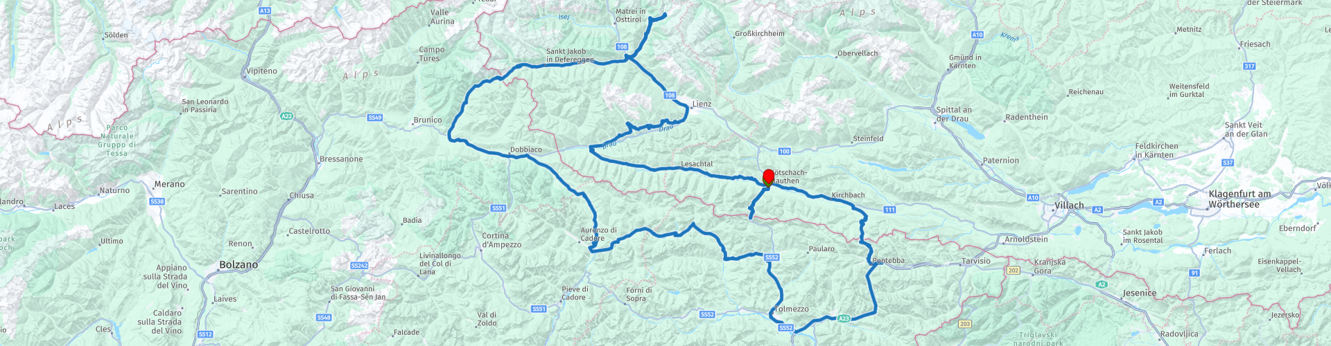
 Start: Kötschach-Mauthen
Finish: Kötschach-Mauthen
The route made the same for TomTom, Garmin and MyRoute-app Navigation users. That has been successful everywhere except in Animals between route points 25 and 26 (Purple), where TomTom and Garmin disagree. Not a big problem, if you drive alone you just follow the instructions of your GPS, if you drive in a group then you follow the driver. From route point 26 the two come together again and your GPS will follow the route correctly again.
If you want to ride this TT, keep the info below in mind:
- Average mountain experience
- Tour
- Accommodation necessary
- Tol
Source: Promoter 07, September / October 2018.
 Share this route


Animation

Verdict


Duration
7h 29m

Mode of travel
Car or motorcycle

Distance
355.50 km

Countries


 RouteXpert Review
 - Passes and mountain roads: Plöcken pass (1360 m), Malga Chiadinis (1967 m) on the Panoramica delle Vette, Passo S. Antonio del Zovo (1482 m), Kreuzberg pass (1636 m), Stallersattel (2052 m), Kalser Glocknerstraße (1920 m), Hochsteinstraße (1900 m), Kartitscher Sattel (1526 m),
Pustertaler Höhenstraße
- Winter closure: Kalser Glockner and Hochsteinstraße November to April / May, Passo S. Antonio del Zovo from December to March and the Panoramica delle Vette October to June.
- Toll: Hochsteinstraße, Kalser Glocknerstraße
- Alternative routes: From Bannberg via the Pustertaler Höhenstraße and further on the Hochsteinstraße to the bottom of the Hochsteinhütte. Then continue on foot (10 minutes). From Huben along the Kalser Glocknerstraße to the parking lot at Neuen Lucknerhaus (nice view of the Großglockner). Alternatively to Val Padola: via the Passo S. Antonio del Zovo. From Tualis to Ravascletto on the unpaved Panoramica delle Vette (can also be done with a street motor in dry weather)
- Ideal months: Due to winter closures from June to October
- Evaring: Panoramica delle Vette requires experience with driving in the mountains.
- Riding pleasure: Lesachtal, Stallersattel, south side Passo S. Antonio del Zovo, Panoramica delle Vette
- Landscape: Lesachtal, Pustertaler Höhenstraße, Kalser Glocknerstraße, Stallersattel
This 5-star route is one of the 24 most beautiful Alpine routes in recent years!
Colored route points:
rp 1 - Starting point in Mauthen at Restaurant & Landhaus Kellerwand
rp 2 - Passo di Monte Croce Carnico - Plöckenpass
rp 4 - Sella Valcalda
rp 5 - Photo stop at Cascata Acquatona
rp 6 - Coffee stop at Bar Fontana
rp 8 - Passo di Sant'Antonio
rp 10 - Kreuzbergpass - Passo di Monte Croce di Comélico
rp 14 - Lunch stop at Hofschänke
rp 15 - Tank stop at Turmöl
rp 16 - Accommodation option at Alpenhof
rp 18 - Photo point, view and coffee stop possible at the Lucknerhaus
rp 20 - Bannberg photo point
rp 24 - Lunch stop at Gasthof Forellenhof
rp 29 - End point in Mauthen at Restaurant & Landhaus Kellerwand, refuel first!
Pay attention:
The route has been made the same for TomTom, Garmin and MyRoute-app Navigation users. That has been successful everywhere except in Animals between route points 25 and 26 (Purple), where TomTom and Garmin disagree. Not a big problem, if you drive alone you just follow the instructions of your GPS, if you drive in a group then you follow the driver. From route point 26 the two come together again and your GPS will follow the route correctly again.


 Links
Links  Usage
Usage Want to download this route?
You can download the route for free without MyRoute-app account. To do so, open the route and click 'save as'. Want to edit this route?
No problem, start by opening the route. Follow the tutorial and create your personal MyRoute-app account. After registration, your trial starts automatically.  Disclaimer
Use of this GPS route is at your own expense and risk. The route has been carefully composed and checked by a MyRoute-app accredited RouteXpert for use on TomTom, Garmin and MyRoute-app Navigation.
Changes may nevertheless have occurred due to changed circumstances, road diversions or seasonal closures. We therefore recommend checking each route before use.
Preferably use the route track in your navigation system. More information about the use of MyRoute-app can be found on the website under 'Community' or 'Academy'.

Veneto
About this region
Veneto (US: , Italian: [ˈvɛːneto]; Venetian: Vèneto [ˈvɛneto]) or Venetia is one of the 20 regions of Italy. Its population is about five million, ranking fourth in Italy. The region's capital is Venice.
Veneto was part of the Roman Empire until the 5th century AD. Later, after a feudal period, it was part of the Republic of Venice until 1797. Venice ruled for centuries over one of the largest and richest maritime republics and trade empires in the world. After the Napoleonic Wars and the Congress of Vienna, the Republic was combined with Lombardy and annexed to the Austrian Empire as the Kingdom of Lombardy–Venetia, until that was merged with the Kingdom of Italy in 1866, as a result of the Third Italian War of Independence.
Besides Italian, most inhabitants also speak Venetian.Since 1971 the Statute of Veneto has referred to the region's citizens as "the Venetian people". Article 1 defines Veneto as an "autonomous Region", "constituted by the Venetian people and the lands of the provinces of Belluno, Padua, Rovigo, Treviso, Venice, Verona and Vicenza", while maintaining "bonds with Venetians in the world". Article 2 sets forth the principle of the "self-government of the Venetian people" and mandates the Region to "promote the historical identity of the Venetian people and civilisation". Despite these affirmations, approved by the Italian Parliament, Veneto is not among the autonomous regions with special statute, differently from its north-eastern and north-western neighbours, Friuli-Venezia Giulia and Trentino-Alto Adige/Südtirol respectively.
Veneto is home to a notable nationalist movement, known as Venetian nationalism or Venetism. The region's largest party is the Liga Veneta, a founding component of the Lega Nord. The current President of Veneto is Luca Zaia (Liga Veneta–Lega Nord), re-elected in 2020 with 76.8% of the vote. An autonomy referendum took place in 2017: 57.2% of Venetians turned out, 98.1% voting "yes" to "further forms and special conditions of autonomy".
Having been for a long period in history a land of mass emigration, Veneto is today one of the greatest immigrant-receiving regions in the country, with 487,493 foreigners (9.9% of the regional population; January 2018), notably including Romanians (25.2%), Moroccans (9.3%), Chinese (7.1%), Moldovans (7.0%) and Albanians (6.9%).
Read more on Wikipedia
Veneto was part of the Roman Empire until the 5th century AD. Later, after a feudal period, it was part of the Republic of Venice until 1797. Venice ruled for centuries over one of the largest and richest maritime republics and trade empires in the world. After the Napoleonic Wars and the Congress of Vienna, the Republic was combined with Lombardy and annexed to the Austrian Empire as the Kingdom of Lombardy–Venetia, until that was merged with the Kingdom of Italy in 1866, as a result of the Third Italian War of Independence.
Besides Italian, most inhabitants also speak Venetian.Since 1971 the Statute of Veneto has referred to the region's citizens as "the Venetian people". Article 1 defines Veneto as an "autonomous Region", "constituted by the Venetian people and the lands of the provinces of Belluno, Padua, Rovigo, Treviso, Venice, Verona and Vicenza", while maintaining "bonds with Venetians in the world". Article 2 sets forth the principle of the "self-government of the Venetian people" and mandates the Region to "promote the historical identity of the Venetian people and civilisation". Despite these affirmations, approved by the Italian Parliament, Veneto is not among the autonomous regions with special statute, differently from its north-eastern and north-western neighbours, Friuli-Venezia Giulia and Trentino-Alto Adige/Südtirol respectively.
Veneto is home to a notable nationalist movement, known as Venetian nationalism or Venetism. The region's largest party is the Liga Veneta, a founding component of the Lega Nord. The current President of Veneto is Luca Zaia (Liga Veneta–Lega Nord), re-elected in 2020 with 76.8% of the vote. An autonomy referendum took place in 2017: 57.2% of Venetians turned out, 98.1% voting "yes" to "further forms and special conditions of autonomy".
Having been for a long period in history a land of mass emigration, Veneto is today one of the greatest immigrant-receiving regions in the country, with 487,493 foreigners (9.9% of the regional population; January 2018), notably including Romanians (25.2%), Moroccans (9.3%), Chinese (7.1%), Moldovans (7.0%) and Albanians (6.9%).
View region
 Statistics
  27
27Amount of RX reviews (Veneto)
 27501
27501Amount of visitors (Veneto)
 4745
4745Amount of downloads (Veneto)
 Route Collections in this region
 The 24 Most Beautiful Alpine Routes
The Alps, The Alps are a mountain range in Europe, stretching from the French Mediterranean coast in the southwest to the Pannonian Plain in the east. The area of the mountain range is more than 200,000 km².
In other words Passes and Mountain Roads!
Driving through the mountains is great! Especially over the mountain passes with hairpin bends and narrow winding roads. Every bend a different view where you can enjoy. There are many beautiful mountain passes in the Alps.
A selection that has also been incorporated into these routes:
The Stlevio Pass:
The Stelvio Pass, also known as Passo dello Stelvio, is mainly known for the stage in the Giro d'Italia. Due to the length and the difference in height, this pass is seen as one of the toughest tests in cycling. The Stelvio Pass reaches a maximum height of 2758 meters and is therefore one of the highest in the Alps. The pass connects the towns of Bormio and Prato Allo Stelvio. In winter the pass is closed due to heavy snowfall.
The Reschenpass:
The Reschenpass, also known as Passo di Resia, connects the Austrian state of Tyrol with the Italian province of South Tyrol. The pass reaches a maximum height of 1,504 meters and has been one of the most important north-south connections in the Alps in recent centuries. The pass was used long before Roman times. Along the way you will pass several highlights and historical relics. One of the highlights is the Reschensee. This lake was created after the construction of the dam and has completely submerged the village of Graun. The only thing that reminds of that is the clock tower in the middle of the lake.
Col du Galibier:
The French mountain pass Col du Galibier connects the towns of Saint-Michel-de-Maurienne and Briançon via the Col du Lautaret in the south and the Col du Télégraphe in the north. The mountain pass is part of the Tour de France and very much feared, due to the fact that it can only be reached via the other two mountain passes. The pass reaches a maximum height of 2646 meters. From there you can take a walk to the viewpoint at 2704 meters. You can admire the peaks of the Grand Galibier, Mont Blanc and La Meije here.
The Grossglockner High Alpine Road:
With a height of 3798 meters the Grossglockner is the highest mountain in Austria. To fully enjoy this impressive mountain, you can drive over the Grossglockner High Alpine Road and the accompanying pass. The route starts from Bruck am Grossglockner and ends in Heiligenblut. Of course you can drive in two directions. The pass reaches a maximum height of 2504 meters and is closed in winter due to heavy snowfall. Along the way you pass several stops with fun activities, information points, mountain huts and viewpoints. A visit to the Kaiser-Franz-Josefs-Höhe and Pasterzen Glacier is highly recommended.
The Col d'Izoard:
Just like the Col du Galibier, the Col d'Izoard is also part of a stage of the Tour de France. The mountain pass connects Briançon with the valley of the river Guil. The pass is partly located in the Regional Natural Park du Queyras and reaches a maximum height of 2360 meters. What is special about the Col d'Izoard is the barren and rocky landscape. Sometimes it feels like driving a car over the moon! Along the way you can stop at several points to enjoy the beautiful view.
The Bernina Pass:
The Bernina Express is one of the most famous rail trains in Switzerland and the Alps. The route is beautiful and partly included on the UNESCO World Heritage List. Parallel to the railway lies the Bernina pass, which connects the Veltlin valley with the Egandin valley. This beautiful Alpine road has a total length of 56 kilometers and reaches a maximum height of 2328 meters. Along the way you can enjoy views of the Morteratsch Glacier.
The Sella Pass:
The Sella Pass, also known as Passo di Sella, takes you over one of the most impressive mountain ranges in the Dolomites: the Sella massif. The pass connects Valle di Fassa with Val Gardena and reaches a maximum height of 2236 meters. At this height is also the border of the Italian provinces of Trentino and Bolzano. Along the way you can enjoy the view of this spectacular mountain world. Admire, for example, the three peaks of the Sasso Lungo massif, the Sella massif or the peaks of the Marmolada. You can also drive the Sella pass in combination with the Gardena pass, Pordoi pass and Campolongo pass.
The Grimsel Pass:
The Grimsel Pass connects Goms in Wallis with the Halis Valley in the Bernese Oberland. The pass reaches a maximum elevation of 2165 meters and is closed in winter due to snowfall. Over the centuries, the mountain pass has played an important role in trade between Switzerland and Italy. Now it is mainly the reservoirs that have an important function. These are used to generate electricity. The landscape you drive through is rugged, rocky and impressive. On top of the pass is a hotel and a restaurant with a special marmot park. The Dodensee (Totensee) is also located here. This lake owes its name to the many soldiers who died in the time of Napoleon.
The Gotthard Pass:
The Gotthard Pass, also known as Passo del San Gottardo and Saint Gotthard, connects the Swiss towns of Airolo and Andermatt. The mountain pass and associated tunnel are especially known among holidaymakers driving from Switzerland to Italy. But where the majority opt for the tunnel, it is precisely the pass that really completes the holiday. The Gotthard Pass has a length of about 26 kilometers and reaches a maximum height of 2106 meters. The route is beautiful and takes you along old villages and beautiful views.
The Silvretta High Alpine Road and Silvretta Pass:
The Paznaun Valley in Tyrol and the Montafon in Vorarlberg are connected by the Silvretta High Alpine Road. The route has a length of 22.3 kilometers and leads from Galtür to Partenen in 34 hairpin bends, via the 2032 meter high Bielerhöhe. The Silvrettasee is also located at this point, where you can enjoy a lovely walk. The pass is closed in winter due to snowfall.
The Simplon Pass:
Just like the Gotthard Pass, many holidaymakers also travel over the Simplon Pass every year. This mountain pass connects the Rhone Valley in the canton of Valais with the Valle d'Ossola in Piemonte. The pass is open all year round and reaches a maximum height of 2005 meters. Along the way you pass a number of buildings, including the well-known Simplon Hospiz from 1825. The hospiz is managed by the monks of St. Bernard. From the highest point on the pass, all kinds of hiking routes are possible and you will also come across a hotel where you can spend the night.
The Gerlos Pass:
The Gerlos Pass connects the Salzach Valley in the Salzburgerland with the Zillertal Valley in Tyrol. The pass is part of the Gerlos Alpenstraße and runs right through the Hohe Tauern National Park. Along the way you can enjoy beautiful views of the surroundings. The pass has a length of 12 kilometers and reaches a maximum height of 1531 meters. A ride over the Gerlos Pass can be ideally combined with a visit to the Krimmler Wasserfälle.
The Great St. Bernard Pass:
The Great St. Bernard Pass, better known as Col du Grand Saint Bernard, connects the Italian province of Valle d'Aosta with the Swiss canton of Valais. The pass is one of the highest in Switzerland and reaches a maximum height of 2469 meters. Like a number of other mountain passes in this list, the Great St. Bernard Pass has also been used as a connecting road for centuries. The pass is named after the St. Bernard dogs that used to help stranded travelers along with the monks. The pass is closed in winter.
The Timmelsjoch High Alpine Road:
The Timmelsjoch High Alpine Road connects the towns of Sölden in the Ötztal and Meran in South Tyrol. Tolls must be paid on the Hochgurgl - Moos route. Via a mountain road with about 60 hairpin bends you drive through a beautiful mountain world. With the Timmelsjoch Experience you can learn more about the history, the road and the environment via various stations. You can also visit the Top Mountain Crosspoint museum.
Col de l'Iseran:
With a maximum pass height of 2770 meters, the Col l'Iséran is one of the highest mountain passes in the Alps. The pass connects Bourg-Saint-Maurice with Bonneval-sur-Arc. Via a road full of hairpin bends you pass, among other things, Val-d'Isère and a side valley of the Maurienne that lies entirely in the National Park de la Vanoise. You can spot animals such as marmots and chamois and there is also a restaurant with a chapel on top of the pass.
The Gavia Pass:
The Gavia Pass (Italian Passo di Gavia) is a mountain pass in the Italian Alps, in the Lombardy region.
It is one of the highest pass roads in Europe. The road leads through the unspoilt Stelvio National Park. The road was built in the First World War to supply Italian soldiers who fought in the Italian-Austrian border area. The pass height is one of the most beautiful in the Alps. Here is the large Lago Bianco with, to the north, the mountain San Matteo (3684 meters). Lago Nero is slightly lower on the south side of the pass. Here the mountain group of the Adamello determines the view. There are many well-marked walks in the area. During the winter the pass is closed due to the heavy snowfall. The pass is often closed until May and June due to the large amount of snow.
Promoter has made a selection of the 24 Most Beautiful Alpine routes that they have set out in recent years.
The routes go through:
France
Austria
Switzerland
Italy
The most beautiful roads, the most beautiful views, the most beautiful viewpoints. The highest mountains, the fastest descents, hairpin bend after hairpin bend, you name it you can't get enough of it.
If you go on holiday in this region, take advantage of it, ALL routes in this collection have been checked and made equal for TomTom, Garmin and MyRoute-app Navigation by a MyRoute-app RouteXpert.
Have fun with this collection and while driving one of these routes. Enjoy all the beauty that the Alps and the Dolomites have to offer. Click on “View route” to read the review of the chosen route.
I would like to hear your findings about the route(s).
View Route Collection
The 8 most beautiful routes of the Dolomites
The Dolomites are a mountain range in Italy that is part of the Southern Limestone Alps. Typical for the Dolomites are the steep rock walls and peaks, which were created by erosion and weathering. The mountain range is split into two parts: the eastern and the western. The highest peak of the Dolomites, the Marmolada, is 3343 meters high.
Enjoy the beautiful routes in the vicinity of the Marmolada. Whichever way you drive in the Dolomites, it is always fantastically beautiful. You get one (toll-free) pass after the other for your wheels and it is pure enjoyment every time. A wonderful playground that changes depending on the hour, depending on the direction, depending on the weather and which completely enchants you!
The routes have been checked and made equal for Garmin, TomTom and MyRoute-app Navigation users. Do you have a fantastic route in the Dolomites that belongs in this list? Send us the route via routeexpert@myrouteapp.com.
Enjoy!
View Route Collection