R03 Voehrenbach to Innertkirchen

This route was brought to you by:
RouteXpert Arno van Lochem - Senior RX
Last edit: 19-09-2022
 Route Summary
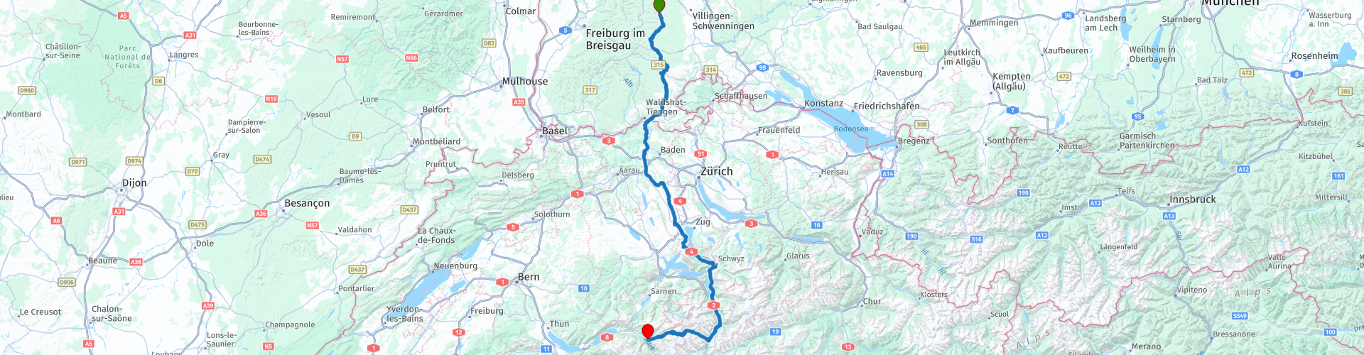
 In this route you drive from Vöhrenbach to the Swiss Innertkirchen, a small town between two passes: The Sustenpass and the Grimselpass. The first part of the route takes you through the beautiful Black Forest towards Switzerland. Once there you will soon see the snowy mountain peaks looming, at the end of the route the first 'real' pass presents itself, the Sustenpas.
The beautiful roads, the beautiful landscapes of the Black Forest, the great views in Switzerland and the nice sights mean that I rate this route with 5 stars.
Given the distances in mountainous areas and the many hairpin bends that can be very narrow at times, this route is suitable for the more advanced motorcyclist.
 Share this route


Animation

Verdict


Duration
7h 16m

Mode of travel
Car or motorcycle

Distance
256.91 km

Countries


 RouteXpert Review
 The route starts in Vöhrenbach at Gasthof zum Ochsen. After 200 meters you can fill the tank if necessary. The route winds, as you may have come to expect from the Black Forest, towards the south over beautifully landscaped roads that are wonderful to steer. Perhaps much too soon for your liking you arrive in Tiengen, a town on the border with Switzerland.
A little later, after the coffee stop at McDonalds, which is equipped with a McCafé, the time has come, you cross the border into Switzerland. The border is again formed by the Rhine, which marks the dividing line between the two countries. This time you cross over a bridge. Before you know it you will be driving in Koblenz. Koblenz? Weren't we there in the first route too? Yes, but this is the Swiss Koblenz, located a little more to the south. :-) Anyway, country number three on the list can be checked off!
You will soon be driving through the meadows and trees again, after about 10 kilometers you will pass the PSI, or the Paul Scherrer Institute. This is the largest research institute for natural and technical sciences in Switzerland. The nice thing is that you can experience research live. You can visit the visitor center PSI Visitor Center, with its interactive exhibits. What are these special buildings on the grounds of the Paul Scherrer Institute? Who are the PSI researchers and what are they working on? What does a large research facility look like on the inside? These questions are answered in the "Visit the Researchers" exhibition in the PSI Visitor Center. Step on the floor marker at the entrance to the exhibition and begin your own personal visit with researchers.
After the research institute, the route winds further south and you soon reach the first large lakes. The Zugersee, named after the place Zug and the Lauerzesee, which takes its name from the place Lauerz. Both beautiful lakes where you drive right along the waterline.
A little further on you drive through the town of Ingenbohl. Driving through the center suddenly the Vierwaldstättersee looms up in front of you. A breathtaking sight, the water with the many boats on it and in the background the mountains that seem to rise from the water. After about a kilometer there is a parking lot where you can take a good look at this beauty and of course take the necessary photos.
After this stop it is still a few kilometers to the lunch address, hotel Tellsplatte in Sisikon. Sitting on the terrace enjoying lunch and a beautiful view of the Vierwaldstättersee, what more could you want?
From the terrace of Hotel Tellsplatte you can see something nice a little lower ago: The largest carillon in Switzerland. The chime consists of 37 bells with the tones e1 to e4 with a weight of approximately 6000 kg. Nice to have a look at, it seems that everyone can operate the carillon for free for the first 10 minutes of every hour (from 009.00).
After this musical interlude, you follow the route further south. At a certain point you turn into Gotthardstrasse at Schattorf. This road is not a punishment at all to drive on. Beautiful asphalt and great views make it a real party.
After 20 kilometers, at Wassen, this party comes to an end spontaneously. You leave Gotthardstrasse by turning right into Sustenstrasse. This is where the first 'real' pass of this journey begins, the Sustenpass with a height of 2224 meters.
The Susten Pass forms the connection between Innertkirchen in the canton of Bern and Wassen in the canton of Uri. The current road was built between 1938 and 1945 and is therefore one of the newer Swiss pass roads. The Sustenpass is little used as a transit route and is especially important for tourism. For this reason, the road is not kept snow-free during the winter.
The highest point of the route over the Sustenpass is located in a short tunnel. On the Bernese side there are several buildings and ample parking spaces. The actual Sustenpas can only be reached on foot. The descent leads through the green Meiental to Wassen in the valley of the river Reuss.
Breathtaking views, beautiful asphalt, wonderful curves, everything that a good pass needs to be found here. Don't forget to stop at the various places where it is possible to fill your memory card with memories.
Although you only have 20 kilometers left of the route if you have Hotel Steingletscher in view, it is wonderful to settle down here for a cup of coffee or something fresh and simply see what is passing by. That, in combination with the views, makes driving on a no-go.
At the bottom of the descent you enter Innertkirchen, also the final destination of this route. Immediately on the right you will find the hotel Hof und Post. This is a nice hotel, located in a great spot between two passes, the Susten and Grimselpasses.
Have fun driving this route!


 Links
Links  Usage
Usage Want to download this route?
You can download the route for free without MyRoute-app account. To do so, open the route and click 'save as'. Want to edit this route?
No problem, start by opening the route. Follow the tutorial and create your personal MyRoute-app account. After registration, your trial starts automatically.  Disclaimer
Use of this GPS route is at your own expense and risk. The route has been carefully composed and checked by a MyRoute-app accredited RouteXpert for use on TomTom, Garmin and MyRoute-app Navigation.
Changes may nevertheless have occurred due to changed circumstances, road diversions or seasonal closures. We therefore recommend checking each route before use.
Preferably use the route track in your navigation system. More information about the use of MyRoute-app can be found on the website under 'Community' or 'Academy'.

Baden-Württemberg
About this region
Baden-Württemberg (; German: [ˌbaːdn̩ ˈvʏʁtəmbɛʁk] (listen)), commonly shortened to BW or BaWü, is a German state (Bundesland) in Southwest Germany, east of the Rhine, which forms the southern part of Germany's western border with France. With more than 11.07 million inhabitants as of 2019 across a total area of nearly 35,752 km2 (13,804 sq mi), it is the third-largest German state by both area (behind Bavaria and Lower Saxony) and population (behind North Rhine-Westphalia and Bavaria). As a federated state, Baden-Württemberg is a partly-sovereign parliamentary republic. The largest city in Baden-Württemberg is the state capital of Stuttgart, followed by Mannheim and Karlsruhe. Other major cities are Freiburg im Breisgau, Heidelberg, Heilbronn, Pforzheim, Reutlingen, Tübingen, and Ulm.
What is now Baden-Württemberg was formerly the historical territories of Baden, Prussian Hohenzollern, and Württemberg. Baden-Württemberg became a state of West Germany in April 1952 by the merger of Württemberg-Baden, South Baden, and Württemberg-Hohenzollern. These states had just been artificially created by the Allies after World War II out of the existing traditional states Baden and Württemberg by their separation over different occupation zones.
Baden-Württemberg is especially known for its strong economy with various industries like car manufacturing, electrical engineering, mechanical engineering, the service sector, and more. It has the third highest gross regional product (GRP) in Germany. Part of the Four Motors for Europe, some of the largest German companies are headquartered in Baden-Württemberg, including Daimler, Porsche, Bosch and SAP.
The sobriquet Ländle (a diminutive of the word "Land" in the local Swabian, Alemannic and Franconian dialects) is sometimes used as a synonym for Baden-Württemberg.
Read more on Wikipedia
What is now Baden-Württemberg was formerly the historical territories of Baden, Prussian Hohenzollern, and Württemberg. Baden-Württemberg became a state of West Germany in April 1952 by the merger of Württemberg-Baden, South Baden, and Württemberg-Hohenzollern. These states had just been artificially created by the Allies after World War II out of the existing traditional states Baden and Württemberg by their separation over different occupation zones.
Baden-Württemberg is especially known for its strong economy with various industries like car manufacturing, electrical engineering, mechanical engineering, the service sector, and more. It has the third highest gross regional product (GRP) in Germany. Part of the Four Motors for Europe, some of the largest German companies are headquartered in Baden-Württemberg, including Daimler, Porsche, Bosch and SAP.
The sobriquet Ländle (a diminutive of the word "Land" in the local Swabian, Alemannic and Franconian dialects) is sometimes used as a synonym for Baden-Württemberg.
View region
 Statistics
  58
58Amount of RX reviews (Baden-Württemberg)
 40748
40748Amount of visitors (Baden-Württemberg)
 9641
9641Amount of downloads (Baden-Württemberg)
 Route Collections in this region
 Top 5 Car and Motorcycle Routes in the Black Forest
The Black Forest, who hasn't heard of it? The Black Forest is a densely forested area and low mountain range in southwestern Germany, located in the state of Baden-Württemberg, on the Rhine and the French border. It is the largest low mountain range in Germany. Geologically, it is related to the Vosges Mountains, which lie on the French side of the Rhine. The highest peak of the Black Forest is the Feldberg with a height of 1493 meters above sea level. The Black Forest is the largest forest area in Germany and consists mainly of pine and spruce trees. The Black Forest is known as one of the most popular tourist destinations in Germany. A small part in the north is protected as the Schwarzwald National Park. The Romans called the densely forested mountain range with its distinctive dark conifers Silva Nigra - "the Black or Dark Forest or impenetrable forest", which to them was ominous and almost impenetrable. The German word Schwarzwald was used for the first time in a document from the Swiss monastery of St. Gallen from the year 868. A well-known car route is the Schwarzwald-Hochstraße, B 500 and the Uhrenstraße. The Black Forest is known worldwide for the fairy tales of the Brothers Grimm.
There are also several lakes in the Black Forest, namely: Titisee, Glaswaldsee, Mummelsee, Kirnbergsee, Feldsee, Schluchsee and the Hotzenwald.
The highest peaks in the Black Forest are: Feldberg (1493 m), Seebuck (1448 m), Herzogenhorn (1415 m), Belchen (1414 m), Schauinsland (1284 m), Kandel (1243 m) and the Hornisgrinde (1164 m ).
Reason enough for the MyRoute app RouteXpert to compile a Top 5 of Car and Motorcycle Routes for you.
All routes in this collection have been checked and made equal for TomTom, Garmin and MyRoute-app Navigation by a MyRoute-app RouteXpert.
If you think, I have a very nice route that should certainly not be missing from this collection, send it to:
email: routeexpert@myrouteapp.com
Subject: New Route for the Top 5 collection Black Forest composed by Hans van de Ven.
The route will then be reviewed and then added to the Top 5. To make the Top 5 also the Top 5, 1 route will have to disappear from the Top 5, you can indicate this when submitting the new route.
Have fun with this collection and while driving one of these routes. Enjoy all the beauty that the Black Forest has to offer. Click on “View route” to read the review of the chosen route.
I would like to hear your findings about the route(s).
View Route Collection
11 day trip from the Netherlands
8 countries in 11 days; The Netherlands, Germany, Austria, Italy, Switzerland, France, Luxembourg and Belgium. This route collections consists of 10 routes that I have driven with friends in the summer of 2019.
The start is in Geldermalsen Netherlands, the first 7 days you drive through the Netherlands, Germany, Austria, Italy, Switzerland, France and a piece of Luxembourg with overnight stays in hotels.
The last three days you stay in Barweiler (D) in the Eifel and you drive two beautiful tours through the Eifel, Luxembourg and parts of the Belgian Ardennes.
There is no highway in the routes, only beautiful provincial and country roads, many beautiful passes with beautiful panoramas.
Be sure to check whether the passes are open before you leave.
These are routes for experienced drivers.
View Route Collection