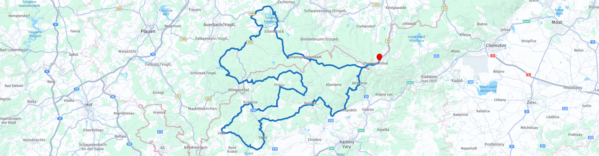
11 Rondrit West Bohemen vanuit Oberwiesenthal

This route was brought to you by:
RouteXpert Leonor Orban - Sr. RouteXpert
Last edit: 17-06-2020
 Route Summary
 This is primarily a tour to enjoy motorcycling. Along the way I only stopped a few times for photos. Nevertheless, I have included a number of sights, where you can stop to look around if you are interested. Think of an old silver and uranium mine, reservoirs, remains from WWII and castles.
Again, a warning applies here that the roads in the Czech Republic are not always of good quality. Keep this in mind while driving. Certainly the smaller roads in the woods can sometimes have holes in the road surface in surprising places.
The route has been made the same for Garmin, TomTom and MyRoute-app Navigation.
 Share this route


Animation

Verdict


Duration
4h 57m

Mode of travel
Car or motorcycle

Distance
241.50 km

Countries


 RouteXpert Review
 The route gets 3.5 stars from me. This is mainly due to the poor road surface in the Czech Republic. The route itself is certainly worth the effort: you will be guided through a number of important areas of the Ore Mountains, past interesting sights. The view is also regularly beautiful and varied.
The ore mountains are mainly known for the intensive mining that took place in the region since 1100. It soon became known that the area was rich in silver, which led to mining activities being created in this area. Later, the mountains also appeared to be rich in minerals such as silver, tin, iron ore, brown coal and cobalt. During this tour you will come across a number of sights that remind you of the intensive mining.
In addition, the Czech part (Karlovy Vary or Karlsbad) in particular is also known for its many natural beneficial springs. Along the way you will also come across a famous spa. More about this later in the review.
The route starts at Hotel Alpina Lodge in Oberwiesenthal. This area is one of the best known winter sports areas and spas in the region. This is partly due to the good air quality and the height. This area houses the 2 highest mountains in the Ore Mountains: the Fichtelberg with 1215 meters in the German part and the Keilberg or Klínovec with 1244 meters in the Czech part.
From the village you drive to the West. You soon enter the Czech Republic where you can refuel in Boží Dar before you start the route. This village is located in a large peat area, which you also cross before you enter Johanngeorgenstadt (Germany). If you look carefully around you, you will see "heaps" or small hills here and there. These remains date from the 16th century and have been used for the search for tin. The area covers around 250,000 m2, making it one of the largest tin mining areas in Eastern Europe (RP3).
More advanced methods for mining work can be found in Johanngeorgenstadt. Here it is also worthwhile to take a closer look and to find out more about mining in the ore mountains. This village has a turbulent past thanks to all mining. The first signs of mining date back to the 15th century, when it became apparent that there were large amounts of silver in the ground. The village was founded in 1654 and mining activities continued to intensify. For example, the first large shaft was excavated, which now houses the Schaubergwerk Frisch Glück "Glöckl" (RP5). You can visit the tunnels here under supervision. Later in the 17th century, a "Pferdegöpel" was also built to drive the mine machines under horsepower. This Pferdegöpel has been rebuilt and can be visited nowadays (RP6).
In the 19th century, more and more Bismuth ore and Uranium ore were mined in the mines. This slowly became the main source of income for the region, as silver prices fell due to the rise of gold as a currency.
In the 20th century, after the Second World War, the mine and the village quickly grew into a gigantic industry. The then USSR claimed the mine to be able to extract as much uranium as possible for the arms race to be able to build a first atomic bomb. At the height of these mining activities, more than 70,000 mines worked in the mine (for reference: up to 5,000 mines worked in the mines before). Due to the rapid growth of mining, the original buildings in the center of Johanngeorgenstadt had to make way. Because of this you will no longer find a village center here.
After visiting the mine it is time to enjoy the air and space around us again. Along the way you will pass the Eibenstock dam. You can stop briefly here to take a photo of the dam (RP7) that provides drinking water for around 600,000 people in the vicinity of the reservoir. Further on the route, space comes into view: the German space museum. Outside the main entrance of the site you can see a fighter plane (RP10). This was flown by Sigmund Jähn, the first German to fly in space (of course in another aircraft ...).
Depending on how much time you have spent in Johangeorgenstadt, you can take a (lunch) break at today's second dam: Talsperre Muldenberg. This dam is smaller than the Elbenstock, but nevertheless offers drinking water to around 100,000 people. Near the dam you will find a restaurant along the road (RP11) where you can have a nice lunch and also take a walk to the reservoir to take some pictures.
After the break you leave the German part of the Ore Mountains and cross the border to the Czech part of the Ore Mountains: Krušné hory. Keep in mind that from now on the roads can be worse.
Along the way you drive through the swamp area of Rolava. You can stop here to visit an emotionally charged place: Sauersack / Rolava tin camp and tin factory (RP12). At the time of WWII, around 500 French and Russian military prisoners were put to work “voluntarily” in the tin factory and mine. It was expected that a lot of tin could be removed from the soil, but within a few years it became clear that there was little tin in the soil. After the war, the factory and mine were closed and the machines moved to other mines in the region. If you like taking urbex photos, this place is perfect.
On the left side of the road you will find the remains of the concrete factory and mine. These can be viewed freely and give a desolate impression. Bear in mind that you must pay attention to where you are walking. The largest mine shafts are covered with concrete plates, but here and there smaller openings to cellars and shafts are overgrown with plants, making it easy to fall into something. The site is unguarded, which means that it has gradually been taken back by nature. The prisoners' wooden barracks used to be on the other side of the road. Nowadays there is little to nothing left of this.
The route leads you through Krušné Hory. Since 2019 this is a UNESCO protected nature reserve, so you can drive through the nature reserve at your leisure. Don't forget to stop occasionally and take beautiful pictures of the area. Because it is so quiet here, you will not encounter much traffic.
Towards the end of the afternoon you turn east again and you also see another side of the history of the nature reserve: Karlovy Vary. Karlovy Vary (or Carlsbad) is known for the many spas and wellness options. Already in the Middle Ages, the healing power of various sources in this region became known, creating the city of Karlovy Vary, but also various spa areas outside the city.
One is Lužec Castle (RP21). This castle was commissioned by King Charles IV in the 14th century (also the namesake of the region and city of Karlovy Vary). This castle was intended as a spa facility during the king's hunting trips. In the following centuries, the castle became famous because King Rudolph II tried to develop the elixir of life here and pilots of the Luftwaffe and Herman Goering regularly stayed here in WWII. Nowadays the castle is a luxury spa hotel where you can take a break. If you would rather have a stopover somewhere else for a break, you can stop on the route at restaurant Havlovka (RP23). This cozy wooden house just next to the route offers a bit more local charm and a beautiful view of the surrounding nature reserve.
After this break it is only a 30 - 45 minute drive to the end point. This depends on how fast you drive of course, but also whether you want to stop for a photo of castle Freudenstein / Šlikův. The castle dates from 1513 and was built to protect the silver mines in the area. Over the years it has been repeatedly knocked down and rebuilt. It eventually fell into disrepair in the 20th century, leaving only the two towers standing. Special fact: oddly enough, the road runs between the two towers. This is because the local government found that the most logical route for the road was across the old cellars of the castle. The cellars are filled with concrete and the road is built over it ...
The last part of the route takes you back to a well-known road: you drive back via Boží Dar where you can stop for a while before you end up at Hotel Alpina Lodge Oberwiesenthal.


 Links
Links  Usage
Usage Want to download this route?
You can download the route for free without MyRoute-app account. To do so, open the route and click 'save as'. Want to edit this route?
No problem, start by opening the route. Follow the tutorial and create your personal MyRoute-app account. After registration, your trial starts automatically.  Disclaimer
Use of this GPS route is at your own expense and risk. The route has been carefully composed and checked by a MyRoute-app accredited RouteXpert for use on TomTom, Garmin and MyRoute-app Navigation.
Changes may nevertheless have occurred due to changed circumstances, road diversions or seasonal closures. We therefore recommend checking each route before use.
Preferably use the route track in your navigation system. More information about the use of MyRoute-app can be found on the website under 'Community' or 'Academy'.
.jpg/1920px-Old_city_hall_of_Leipzig_(20).jpg)
Saxony
About this region
Saxony is a landlocked state of Germany, bordering the states of Brandenburg, Saxony-Anhalt, Thuringia, Bavaria, as well as the countries of Poland and the Czech Republic. Its capital is Dresden, and its largest city is Leipzig. Saxony is the tenth largest of Germany's sixteen states, with an area of 18,413 square kilometres (7,109 sq mi), and the sixth most populous, with more than 4 million inhabitants.
The history of Saxony spans more than a millennium. It has been a medieval duchy, an electorate of the Holy Roman Empire, a kingdom, and twice a republic. The first Free State of Saxony was established in 1918 as a constituent state of the Weimar Republic. After World War II, it became part of the German Democratic Republic and was abolished by the communist government in 1952. Following German reunification, the Free State of Saxony was reconstituted with enlarged borders in 1990 and became one of the five new states of the Federal Republic of Germany.
The area of the modern state of Saxony should not be confused with Old Saxony, the area inhabited by Saxons. Old Saxony corresponds roughly to the modern German states of Lower Saxony, Saxony-Anhalt, and the Westphalian part of North Rhine-Westphalia.
Read more on Wikipedia
The history of Saxony spans more than a millennium. It has been a medieval duchy, an electorate of the Holy Roman Empire, a kingdom, and twice a republic. The first Free State of Saxony was established in 1918 as a constituent state of the Weimar Republic. After World War II, it became part of the German Democratic Republic and was abolished by the communist government in 1952. Following German reunification, the Free State of Saxony was reconstituted with enlarged borders in 1990 and became one of the five new states of the Federal Republic of Germany.
The area of the modern state of Saxony should not be confused with Old Saxony, the area inhabited by Saxons. Old Saxony corresponds roughly to the modern German states of Lower Saxony, Saxony-Anhalt, and the Westphalian part of North Rhine-Westphalia.
View region
 Statistics
  7
7Amount of RX reviews (Saxony)
 19780
19780Amount of visitors (Saxony)
 955
955Amount of downloads (Saxony)
 Route Collections in this region
 Tour Poland Slovakia and the Czech Republic
This collection of routes is based on a 3-week vacation that I rode with my partner in June 2018.
The journey goes through Poland, Slovakia, the Czech Republic and a piece of Germany. In total there are 11 driving days, a combination of touristic tours and routes from A to B. All routes avoid the highway and go exclusively on the smaller roads, which makes it a beautiful and varied journey.
Along the way you regularly come across sights, where you can stop to look around. These vary from beautiful viewpoints, to museums and special buildings. You also visit various national nature parks along the way, such as the Tatra Mountains, the Giant Mountains, Eagle Mountains, Krkonoše and Bohemian Switzerland. Because the overnight places are often also located in these areas, you can alternate the driving days with days with wonderful hiking trips.
If you only want to ride a motorcycle, then this collection can also be done in 2 weeks (including a return trip from the Netherlands).
The routes themselves can be challenging from time to time, particularly because the quality of the road surface in Eastern Europe - especially on the small country roads - is not always good. In June 2018 all routes were on paved roads.
View Route Collection
Round trip through the Czech Republic from Bergen in Limburg
This tour where you are discharged through the Czech Republic via 10 beautiful routes from Bergen (L), takes you to the following Czech cities; Harrachov is located on the west side of the Giant Mountains, a few kilometers from the Polish border. From here you will make the 3 round trips. The next place is Rychnov, with its many imposing buildings. But also Prague, the city of 100 towers, the historic center, the castle of Prague and of course you cross the river Vltava via the Charles Bridge, a city to stay longer than 1 day. This round trip is completed with 1 overnight stay in Germany on the way there and 2 on the way back.
View Route Collection