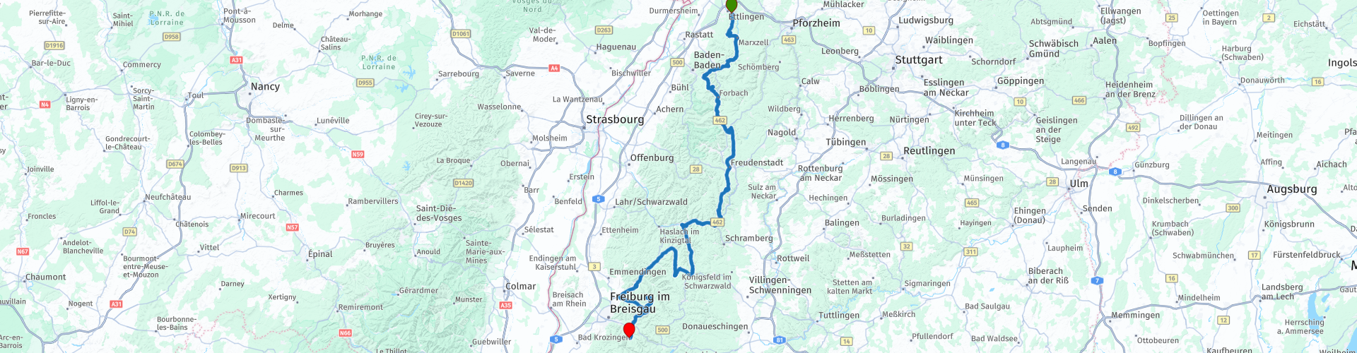
van Ettlingen naar Oberried door het Zwarte Woud

This route was brought to you by:
RouteXpert Eric Wilderbeek
Last edit: 10-08-2021
 Route Summary
 Because the "larger" cities are avoided, you mainly come through small farming villages where you can get a delicious "kaffee mit kuchen" at the local bakery.
This route is easy to drive from the Netherlands and this prevents a large number of boring highway kilometers.
This route gets 4 stars from me because:
The route takes you through beautiful forest areas where the landscape becomes more and more hilly as you drive south. The well-known half-timbered houses are left and right along the road and the villages you drive through radiate "gemutlichkeit". Several mountain peaks from 800 to 1,000 meters can be seen along the route.
The roads are very easy to drive, clear and the bends are smooth and wonderful to drive.
Along the route there is mainly a lot of nature to see, but also farming villages and the advantage is that there are few traffic lights.
 Share this route


Animation

Verdict


Duration
5h 44m

Mode of travel
Car or motorcycle

Distance
225.96 km

Countries

 RouteXpert Review
 This route takes you from the north of the Black Forest to the heart of the Black Forest and avoids many boring highway kilometers towards the Freiburg area. Think of this as an alternative that will require you to schedule some extra time but is well worth leaving home an hour or two early.
Just below Karlsruhe you go off the highway and you arrive at the starting point. You can stop here but also pick up the route at the same time. You drive through the beautiful forests and are immediately treated to lovely rolling bends that are great for the average motorcyclist to loosen up after the (possible) highway kilometers to get to the starting point. You get into your rhythm, feel the stress slide off you and surrender to the joy of motorcycling.
We ignore the well-known SchwarzwaldhochstraBe and look for the more unknown roads. From Ettlingen we head for the river Alb, which we follow for a while until Bad Herrenalb. In the direction of Loffenau we get the first tighter bends, just short of hairpin bends, after which we leave the main roads for a while and can enjoy peace and quiet via small roads. We head further south to Freudenstadt.
Freudenstadt is located at an altitude of approximately 730 metres. It is the Kreisstadt of the Landkreis Freudenstadt. The city has 23,442 inhabitants. Freudenstadt's main church is the only structure that survived a bombing raid by the Americans followed by artillery shelling by French troops during World War II in April 1945. The rest of the city was reduced to ashes.
After Freudenstadt you notice that more altitude meters have to be conquered. And altimeters also means there are waterfalls. In Triberg in Schwarzwald can take a walk to the waterfalls of Triberg. These waterfalls are one of the largest in Germany. The River Gutach meanders through the Black Forest. At the falls, the water of the river falls from a height of 872 meters to a height of 711 meters above NAP. The Gutach runs over a sloping plateau to finally plunge 163 meters in 7 large steps into the V-shaped valley of Triberg.
Just past Schonach im Schwarzwald you will rise above 1,000 meters for the first time. At Waldkirch you start at the first pass of this route, the Kandel-Pass, with a height of 1,241 meters, a length of 24 km and a maximum gradient of 15%. This pass is a nice warm-up for the coming days and a nice end to the first day so we head towards the end point in Oberried at Hotel Goldener Adler for a good meal and a nice drink. Tomorrow fresh up for the second day along the German Alpenstrasse.


 Links
Links  Usage
Usage Want to download this route?
You can download the route for free without MyRoute-app account. To do so, open the route and click 'save as'. Want to edit this route?
No problem, start by opening the route. Follow the tutorial and create your personal MyRoute-app account. After registration, your trial starts automatically.  Disclaimer
Use of this GPS route is at your own expense and risk. The route has been carefully composed and checked by a MyRoute-app accredited RouteXpert for use on TomTom, Garmin and MyRoute-app Navigation.
Changes may nevertheless have occurred due to changed circumstances, road diversions or seasonal closures. We therefore recommend checking each route before use.
Preferably use the route track in your navigation system. More information about the use of MyRoute-app can be found on the website under 'Community' or 'Academy'.

Baden-Württemberg
About this region
Baden-Württemberg (; German: [ˌbaːdn̩ ˈvʏʁtəmbɛʁk] (listen)), commonly shortened to BW or BaWü, is a German state (Bundesland) in Southwest Germany, east of the Rhine, which forms the southern part of Germany's western border with France. With more than 11.07 million inhabitants as of 2019 across a total area of nearly 35,752 km2 (13,804 sq mi), it is the third-largest German state by both area (behind Bavaria and Lower Saxony) and population (behind North Rhine-Westphalia and Bavaria). As a federated state, Baden-Württemberg is a partly-sovereign parliamentary republic. The largest city in Baden-Württemberg is the state capital of Stuttgart, followed by Mannheim and Karlsruhe. Other major cities are Freiburg im Breisgau, Heidelberg, Heilbronn, Pforzheim, Reutlingen, Tübingen, and Ulm.
What is now Baden-Württemberg was formerly the historical territories of Baden, Prussian Hohenzollern, and Württemberg. Baden-Württemberg became a state of West Germany in April 1952 by the merger of Württemberg-Baden, South Baden, and Württemberg-Hohenzollern. These states had just been artificially created by the Allies after World War II out of the existing traditional states Baden and Württemberg by their separation over different occupation zones.
Baden-Württemberg is especially known for its strong economy with various industries like car manufacturing, electrical engineering, mechanical engineering, the service sector, and more. It has the third highest gross regional product (GRP) in Germany. Part of the Four Motors for Europe, some of the largest German companies are headquartered in Baden-Württemberg, including Daimler, Porsche, Bosch and SAP.
The sobriquet Ländle (a diminutive of the word "Land" in the local Swabian, Alemannic and Franconian dialects) is sometimes used as a synonym for Baden-Württemberg.
Read more on Wikipedia
What is now Baden-Württemberg was formerly the historical territories of Baden, Prussian Hohenzollern, and Württemberg. Baden-Württemberg became a state of West Germany in April 1952 by the merger of Württemberg-Baden, South Baden, and Württemberg-Hohenzollern. These states had just been artificially created by the Allies after World War II out of the existing traditional states Baden and Württemberg by their separation over different occupation zones.
Baden-Württemberg is especially known for its strong economy with various industries like car manufacturing, electrical engineering, mechanical engineering, the service sector, and more. It has the third highest gross regional product (GRP) in Germany. Part of the Four Motors for Europe, some of the largest German companies are headquartered in Baden-Württemberg, including Daimler, Porsche, Bosch and SAP.
The sobriquet Ländle (a diminutive of the word "Land" in the local Swabian, Alemannic and Franconian dialects) is sometimes used as a synonym for Baden-Württemberg.
View region
 Statistics
  58
58Amount of RX reviews (Baden-Württemberg)
 40857
40857Amount of visitors (Baden-Württemberg)
 9656
9656Amount of downloads (Baden-Württemberg)
 Route Collections in this region
 Top 5 Car and Motorcycle Routes in the Black Forest
The Black Forest, who hasn't heard of it? The Black Forest is a densely forested area and low mountain range in southwestern Germany, located in the state of Baden-Württemberg, on the Rhine and the French border. It is the largest low mountain range in Germany. Geologically, it is related to the Vosges Mountains, which lie on the French side of the Rhine. The highest peak of the Black Forest is the Feldberg with a height of 1493 meters above sea level. The Black Forest is the largest forest area in Germany and consists mainly of pine and spruce trees. The Black Forest is known as one of the most popular tourist destinations in Germany. A small part in the north is protected as the Schwarzwald National Park. The Romans called the densely forested mountain range with its distinctive dark conifers Silva Nigra - "the Black or Dark Forest or impenetrable forest", which to them was ominous and almost impenetrable. The German word Schwarzwald was used for the first time in a document from the Swiss monastery of St. Gallen from the year 868. A well-known car route is the Schwarzwald-Hochstraße, B 500 and the Uhrenstraße. The Black Forest is known worldwide for the fairy tales of the Brothers Grimm.
There are also several lakes in the Black Forest, namely: Titisee, Glaswaldsee, Mummelsee, Kirnbergsee, Feldsee, Schluchsee and the Hotzenwald.
The highest peaks in the Black Forest are: Feldberg (1493 m), Seebuck (1448 m), Herzogenhorn (1415 m), Belchen (1414 m), Schauinsland (1284 m), Kandel (1243 m) and the Hornisgrinde (1164 m ).
Reason enough for the MyRoute app RouteXpert to compile a Top 5 of Car and Motorcycle Routes for you.
All routes in this collection have been checked and made equal for TomTom, Garmin and MyRoute-app Navigation by a MyRoute-app RouteXpert.
If you think, I have a very nice route that should certainly not be missing from this collection, send it to:
email: routeexpert@myrouteapp.com
Subject: New Route for the Top 5 collection Black Forest composed by Hans van de Ven.
The route will then be reviewed and then added to the Top 5. To make the Top 5 also the Top 5, 1 route will have to disappear from the Top 5, you can indicate this when submitting the new route.
Have fun with this collection and while driving one of these routes. Enjoy all the beauty that the Black Forest has to offer. Click on “View route” to read the review of the chosen route.
I would like to hear your findings about the route(s).
View Route Collection
11 day trip from the Netherlands
8 countries in 11 days; The Netherlands, Germany, Austria, Italy, Switzerland, France, Luxembourg and Belgium. This route collections consists of 10 routes that I have driven with friends in the summer of 2019.
The start is in Geldermalsen Netherlands, the first 7 days you drive through the Netherlands, Germany, Austria, Italy, Switzerland, France and a piece of Luxembourg with overnight stays in hotels.
The last three days you stay in Barweiler (D) in the Eifel and you drive two beautiful tours through the Eifel, Luxembourg and parts of the Belgian Ardennes.
There is no highway in the routes, only beautiful provincial and country roads, many beautiful passes with beautiful panoramas.
Be sure to check whether the passes are open before you leave.
These are routes for experienced drivers.
View Route Collection