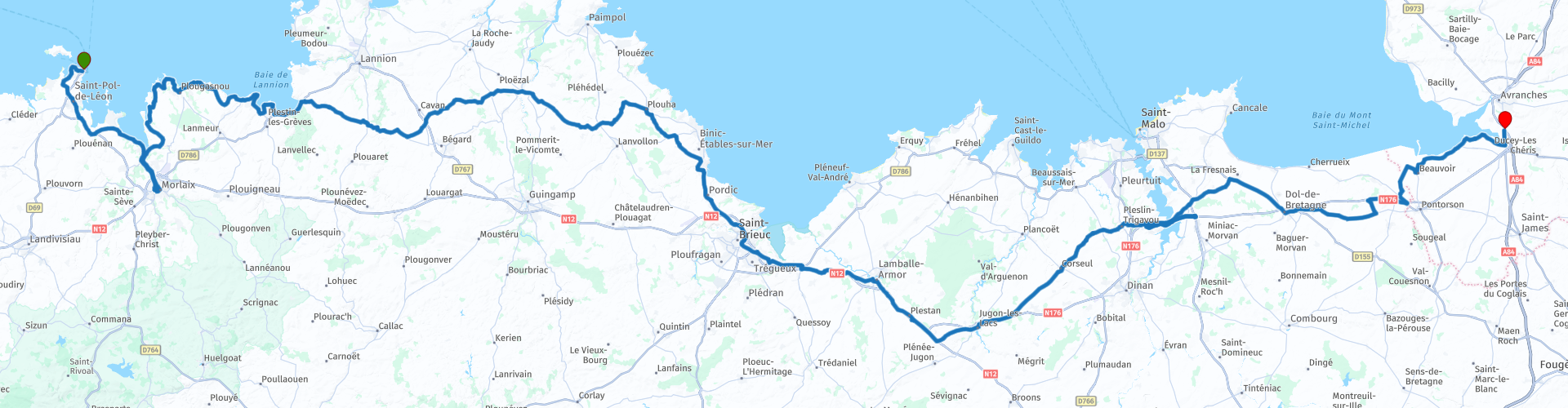
Roscoff to Avranches via Mont Saint Michel

This route was brought to you by:
RouteXpert Nick Carthew - (MRA Master)
Last edit: 17-08-2021
 Route Summary
 I have awarded 4**** stars for this route because of the magnificent coastal views and peaceful rural landscapes on a mixture of roads suitable for all.
 Share this route


Animation

Verdict


Duration
5h 28m

Mode of travel
Car or motorcycle

Distance
294.90 km

Countries

 RouteXpert Review
 Leaving Morlaix behind, you head north on the opposite bank of the river to join up again with the rugged coast. The Brittany shoreline is made up of many small bays and this route will takes you around a few of them.
There is a rural museum at RP 17, Musée Rural du Trégor. This is full tools and equipment that were used in bygone days.
There's a coffee stop with great views and a bit more of the coast to explore before heading inland at Saint-Michel-en-Grève.
The rural roads and landscape is equally as pleasant to the traveller, passing through beautiful stone built villages all having their own magnificent churches standing proud. You'll reach the Côtes-d'Armor or coast of the sea at Binic ‑ Etables‑sur‑mer where I have suggested a lunch stop. There is a car park for cars and motorcycles can park on the pavement by the roundabout.
Once a little medieval village, Binic grew to become one of the most important ports in the French fishing industry. It was the expeditions of the ‘terre-neuvas’ – the fishermen that left France to fish in Newfoundland waters – that secured Binic its place in history, and the imposing granite and schist ship-owners’ houses lining the Quai Jean Bart are testament to this prosperous business. As you can imagine, seafood is offered at most of the many restaurants, bon appetit.
After lunch, the route uses a couple of faster roads to take you to from Brittany to Normandy. It's only an hour on generally quiet roads with pleasant views of the surrounding countryside and you have a chance to top up with fuel at RP 34.
Within a couple of minutes of leaving the dual carriageway, you'll get your first glimpse of Mont St Michel.
Mont Saint Michel is one of Europe’s most unforgettable sights. Set in the mesmerising bay where Normandy and Brittany merge, the island draws the eye from great distances. The staggering location has long inspired awe and the imagination. This remarkable medieval walled city, crowned by its great gothic abbey, is built on a small granite outcrop standing all by itself in the flats of the estuary of the river Couesnon, in an area now known as Mont Saint Michel bay. Mont Saint Michel was one of the first monuments to be classed as a UNESCO world heritage site, as far back as 1979.
Recently, the visitor car parks have been relocated away from the shoreline, to preserve the Mont Saint Michel’s exceptional surroundings. The new car parks stand approximately 1.5 miles away from the island. Once you have parked, head for the Place des Navettes, where specially devised, ultra-modern shuttle buses called Passeurs will take you to the mount itself. These Passeurs operate daily, at very regular intervals, from 7.30am to midnight.
The route leaving Mont St Michel travels through rich agricultural farmland offering some great views back towards the island, don't forget to turn your head to check for views. You will pass by several ancient farm buildings alerting you to the history of rural life in this area. Crossing over La Selune River leaves you just a few minutes away from the ibis Budget hotel on the outskirts of Avranches.


 Links
Links  Usage
Usage Want to download this route?
You can download the route for free without MyRoute-app account. To do so, open the route and click 'save as'. Want to edit this route?
No problem, start by opening the route. Follow the tutorial and create your personal MyRoute-app account. After registration, your trial starts automatically.  Disclaimer
Use of this GPS route is at your own expense and risk. The route has been carefully composed and checked by a MyRoute-app accredited RouteXpert for use on TomTom, Garmin and MyRoute-app Navigation.
Changes may nevertheless have occurred due to changed circumstances, road diversions or seasonal closures. We therefore recommend checking each route before use.
Preferably use the route track in your navigation system. More information about the use of MyRoute-app can be found on the website under 'Community' or 'Academy'.

Normandy
About this region
Normandy (/ˈnɔːrməndi/; French: Normandie [nɔʁmɑ̃di] (About this soundlisten); Norman: Normaundie; from Old French Normanz, plural of Normant, originally from the word for "northman" in several Scandinavian languages)[2] is a geographical and cultural region in Northwestern Europe, roughly coextensive with the historical Duchy of Normandy.
Normandy comprises mainland Normandy (a part of France) and the Channel Islands (mostly the British Crown Dependencies). It covers 30,627 square kilometres (11,825 sq mi).[3] Its population is 3,499,280. The inhabitants of Normandy are known as Normans,[1] and the region is the historic homeland of the Norman language. Large settlements include Rouen, Le Havre and Cherbourg.
The cultural region of Normandy is roughly similar to the historical Duchy of Normandy, which includes small areas now part of the departments of Mayenne and Sarthe. The Channel Islands (French: Îles Anglo-Normandes) are also historically part of Normandy; they cover 194 square kilometres (75 sq mi)[4] and comprise two bailiwicks: Guernsey and Jersey, which are British Crown Dependencies.
Normandy's name comes from the settlement of the territory by Vikings ("Northmen") starting in the 9th century, and confirmed by treaty in the 10th century between King Charles III of France and the Viking jarl Rollo. For four hundred years following the Norman conquest of England in 1066, Normandy and England were linked by having the same person reign as both Duke of Normandy and King of England.
Read more on Wikipedia
Normandy comprises mainland Normandy (a part of France) and the Channel Islands (mostly the British Crown Dependencies). It covers 30,627 square kilometres (11,825 sq mi).[3] Its population is 3,499,280. The inhabitants of Normandy are known as Normans,[1] and the region is the historic homeland of the Norman language. Large settlements include Rouen, Le Havre and Cherbourg.
The cultural region of Normandy is roughly similar to the historical Duchy of Normandy, which includes small areas now part of the departments of Mayenne and Sarthe. The Channel Islands (French: Îles Anglo-Normandes) are also historically part of Normandy; they cover 194 square kilometres (75 sq mi)[4] and comprise two bailiwicks: Guernsey and Jersey, which are British Crown Dependencies.
Normandy's name comes from the settlement of the territory by Vikings ("Northmen") starting in the 9th century, and confirmed by treaty in the 10th century between King Charles III of France and the Viking jarl Rollo. For four hundred years following the Norman conquest of England in 1066, Normandy and England were linked by having the same person reign as both Duke of Normandy and King of England.
View region
 Statistics
  15
15Amount of RX reviews (Normandy)
 18714
18714Amount of visitors (Normandy)
 1542
1542Amount of downloads (Normandy)
 Route Collections in this region
 3 day mini break through Brittany and Normandy
The overnight ferry crossing from Plymouth to Roscoff is a relaxing way to begin your 3 days of sightseeing in North West France. Touring the coasts and countryside of Brittany and Normandy, you'll discover beautiful sandy beaches, tiny fishing ports, bustling market towns and iconic and historical sites. Don't forget to sample Brittany's renowned seafood and delicious sweet and savoury pancakes, or Normandy cider and of course their 'hard to say no to' apple brandy, Calvados .
Day 1 takes you along the beautiful and rugged coast to Mont St Michel, a World Heritage site, visible for miles around. This is a wonderful place at any time of year, although be prepared for it to be very busy in summer. Your first hotel is just 30 minutes further along the coast at Hôtel Ibis Avranches Baie du Mont Saint-Michel. Other hotels are nearby and links for this hotel and your second night at Port en Bessin are in the individual route reviews.
Day 2 takes you first to Bayeux, world famous for its astonishing tapestry depicting the Norman Conquest of England in 1066, remarkable as a work of art and important as a source for 11th-century history. Bayeux also has a picturesque old quarter, WW2 museum and cathedral worth visiting (park motorcycles next to cathedral).
Then you can take in the sobering atmosphere at Pegasus Bridge, liberated by the British 6th Airborne Division glider unit, a full size replica of a Horsa glider shown in the picture above is on display, and the tale of the men it transported gives you a remarkable insight into the scale, ferocity and poignancy of Operation Overlord. Arromanches' Mulberry Harbour (Port Winston) and the gun emplacements dotted along the coast that you'll visit are reminders of the combats that took place here over 70 years ago. A great night is guaranteed at your second hotel in the fishing port of Port en Bessin where you can sample local cider (cidre) some of the freshest seafood available, fine wine, and finish off with some local calvados.
Day 3 tells the American story of D-Day with visits to Omaha and Utah beaches, various museums and the first town in France to be liberated during operation Overlord - Sainte-Mère-Eglise where an effigy of private John Steele dangles by his parachute from the church steeple.
Your return to the UK is via Cherbourg, to either Poole or Plymouth depending on the time of year, most sailings are around 17:00 hrs. Details from Brittany Ferries can be found in the link in the first review.
This is a great mini tour that'll give you a good glimpse of what this part of northern France has to offer and will leave you wanting to return.
View Route Collection
The 10 most downloaded routes in France from RouteXpert Catherine De Groote
Hello and welcome to this collection of the Top 10 MyRoute app downloaded routes in France.
A great new event will be announced soon, where all of these routes can be driven.
Download them all now and place them in a new "Top 10" folder so that you always have them at hand.
If you are going to drive one of these routes in the meantime, track them with the MRA Mobile App or with MRA Navigation. Take some photos (moments) along the way as they will come in handy.
Create a travelogue of your Top 10 driven routes and add the recorded track to it.
There will also be some great prizes on offer, so keep an eye on the MRA-RouteXperts page and your email.
View Route Collection