Rondrit Miesitz Thuringen Ertsgebergte

This route was brought to you by:
RouteXpert Hans van de Ven (Mr.MRA)
Last edit: 03-03-2019
 Route Summary
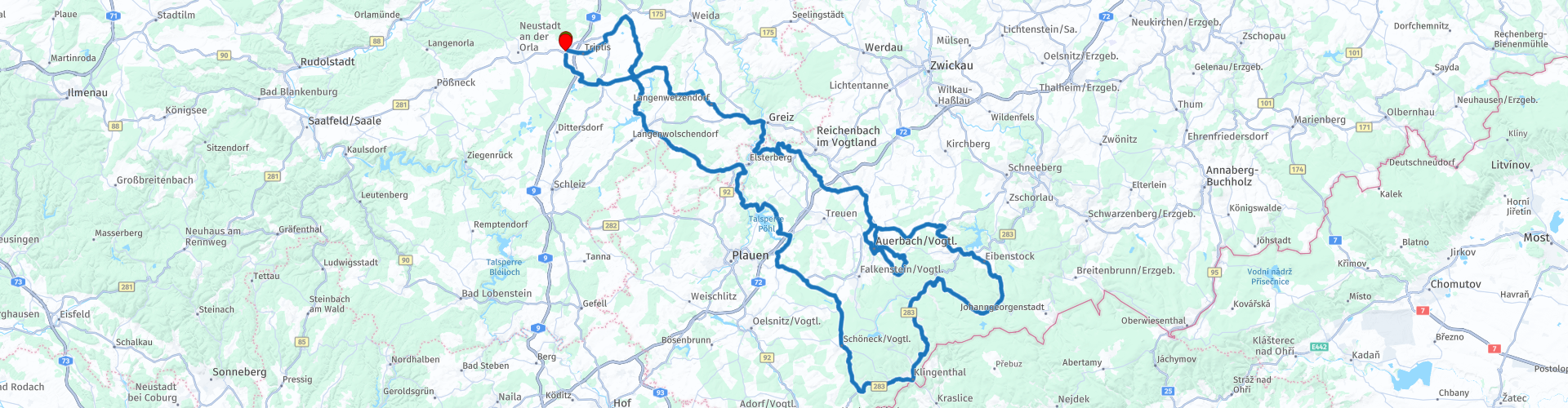
 Start: Hotel Wutzler in Miesitz.
End point: Hotel Wutzler in Miesitz.
 Share this route


Animation

Verdict


Duration
5h 9m

Mode of travel
Car or motorcycle

Distance
248.26 km

Countries

 RouteXpert Review
 The city Klingenthal is known for the production of musical instruments. After a little 50 km we drive against the, as it turned out, 1st road closure. Because of this closure we arrived at an old railway bridge, stop for a while then just take some pictures. It turned out to be the Göltzschthalbrücke.
After a small 75 and 90 km we drive against closure 2 and 3, so we have to change the plans again. From the road closures I marked the route points "Purple". A kind of loop driven to end up in the Erzgebirge, here you are largely about beautiful motor roads.
After the Erzgebirge, as mentioned before we arrive in Klingenthal. Unfortunately also in Klingenthal (too) many road diversions and closures. You can see it!
On the way a few times stopped for the inner man and then again. We drive on and in the direction of Barthmuhle, after the bridge we get a descent about cobblestones of 19%, luckily it is dry!
We continue towards the hotel on mostly smaller roads. Just refuel and go to the hotel for a delicious beer.


 Usage
Usage Want to download this route?
You can download the route for free without MyRoute-app account. To do so, open the route and click 'save as'. Want to edit this route?
No problem, start by opening the route. Follow the tutorial and create your personal MyRoute-app account. After registration, your trial starts automatically.  Disclaimer
Use of this GPS route is at your own expense and risk. The route has been carefully composed and checked by a MyRoute-app accredited RouteXpert for use on TomTom, Garmin and MyRoute-app Navigation.
Changes may nevertheless have occurred due to changed circumstances, road diversions or seasonal closures. We therefore recommend checking each route before use.
Preferably use the route track in your navigation system. More information about the use of MyRoute-app can be found on the website under 'Community' or 'Academy'.

Thuringia
About this region
Thuringia (English: ; German: Thüringen [ˈtyːʁɪŋən] (listen)), officially the Free State of Thuringia (Freistaat Thüringen [ˈfʁaɪʃtaːt ˈtyːʁɪŋən]), is a state of Germany. Located in central Germany, it covers 16,171 square kilometres (6,244 sq mi), being the sixth smallest of the sixteen German States (including City States). It has a population of about 2.1 million.Erfurt is the state capital and largest city. Other cities are Jena, Gera and Weimar. Thuringia is bordered by Bavaria, Hesse, Lower Saxony, Saxony-Anhalt, and Saxony. It has been known as "the green heart of Germany" (das grüne Herz Deutschlands) from the late 19th century due to its broad, dense forest. Most of Thuringia is in the Saale drainage basin, a left-bank tributary of the Elbe.
Thuringia is home to the Rennsteig, Germany's best-known hiking trail. Its winter resort of Oberhof makes it a well-equipped winter sports destination – half of Germany's 136 Winter Olympic gold medals as of 2014 were by Thuringian athletes. Thuringia was favoured or was the birthplace of three key intellectuals and leaders in the arts: Johann Sebastian Bach, Johann Wolfgang von Goethe, and Friedrich Schiller. The state has the University of Jena, the Ilmenau University of Technology, the University of Erfurt, and the Bauhaus University of Weimar.
Thuringia had an earlier existence as the Frankish Duchy of Thuringia, established around 631 AD by King Dagobert I. The state was established in 1920 as a state of the Weimar Republic from a merger of the Ernestine duchies, save for Saxe-Coburg. After World War II, Thuringia came under the Soviet occupation zone in Allied-occupied Germany, and its borders were reformed, to become contiguous. Thuringia became part of the German Democratic Republic in 1949 but was dissolved in 1952 during administrative reforms, to be divided into the Districts of Erfurt, Suhl and Gera. Thuringia was re-established in 1990 following German reunification, slightly re-drawn, and became one of the new states of the Federal Republic of Germany.
Read more on Wikipedia
Thuringia is home to the Rennsteig, Germany's best-known hiking trail. Its winter resort of Oberhof makes it a well-equipped winter sports destination – half of Germany's 136 Winter Olympic gold medals as of 2014 were by Thuringian athletes. Thuringia was favoured or was the birthplace of three key intellectuals and leaders in the arts: Johann Sebastian Bach, Johann Wolfgang von Goethe, and Friedrich Schiller. The state has the University of Jena, the Ilmenau University of Technology, the University of Erfurt, and the Bauhaus University of Weimar.
Thuringia had an earlier existence as the Frankish Duchy of Thuringia, established around 631 AD by King Dagobert I. The state was established in 1920 as a state of the Weimar Republic from a merger of the Ernestine duchies, save for Saxe-Coburg. After World War II, Thuringia came under the Soviet occupation zone in Allied-occupied Germany, and its borders were reformed, to become contiguous. Thuringia became part of the German Democratic Republic in 1949 but was dissolved in 1952 during administrative reforms, to be divided into the Districts of Erfurt, Suhl and Gera. Thuringia was re-established in 1990 following German reunification, slightly re-drawn, and became one of the new states of the Federal Republic of Germany.
View region
 Statistics
  24
24Amount of RX reviews (Thuringia)
 15977
15977Amount of visitors (Thuringia)
 3042
3042Amount of downloads (Thuringia)
 Route Collections in this region
 The ANWB ProMotor Tank Bag Tours of 2009
Since the early 1990s, Promoter has been organizing the so-called TankTasTochten. You will understand that the name dates back to the GPS-less era, when motorcyclists were still trying to find their way on back roads with a road book in the tank bag or route roll.
You have also seen the TankTasTochten of 2009 come along one by one, from now on also as a collection from 2009.
All routes in this collection have been checked and made equal for TomTom, Garmin and MyRoute-app Navigation by a MyRoute-app RouteXpert. The routes follow as much as possible the original route as it was made at the time.
In this collection you will visit the following provinces:
South Holland
Utrecht
Overijssel
Gelderland
Friesland
Drenthe
Lower Saxony (Germany)
North Rhine Westphalia (Germany)
Harz (Germany)
Thuringia (Germany)
Saxony Anhalt (Germany)
Limburg
Limburg (Belgium)
Liège (Belgium)
*In this collection a 3-day trip to the Harz!
Have fun with this collection and while driving one of these routes. Enjoy all the beauty that the Netherlands, Germany and Belgium have to offer. Click on “View route” to read the review of the chosen route.
I would like to hear your findings about the route(s).
View Route Collection
Castle Route Burgenstrasse from Mannheim to Bayreuth
The Burgenstrasse is a well-known historic autoroute through southern Germany. This beautiful route goes over 1200 km through (mainly) the federal states of Baden-Württemberg and Bavaria. The route once continued for another 400 kilometers in the Czech Republic. These routes are not in this collection.
The route passes more than 80 castles, fortresses and noble residences. This route collection takes you past all these castles and even more sights. Stops have been made for the most beautiful sights. Enjoy the gentle slopes, sweeping views and of course the beautiful castles and historic towns and cities that you will visit along the way. Tip: treat yourself to an overnight stay in a castle! Several castles on the route have been converted into hotels.
Of course you can also drive the routes without seeing sights, then you will be able to drive more routes in 1 day. The routes connect to each other. The routes are made from west to east, but are of course easy to turn around. The routes are each between 100 and 200 kilometers long (between 6 and 8 hours, depending on how many stops you make and how long you stop) and contain the castles as waypoints, some photos and websites and especially many tips for stops along the way.
View Route Collection