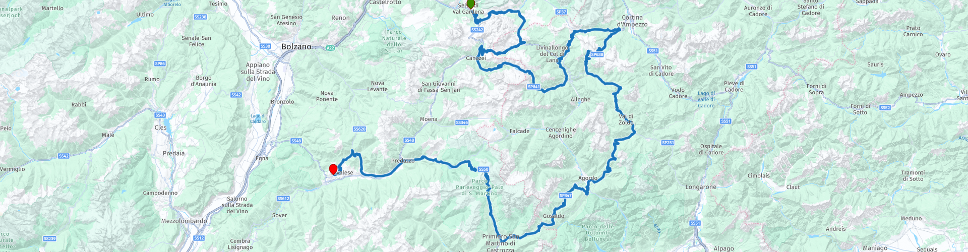
R06 Selva di Val Gardena to Castello Molina di Fiemme

This route was brought to you by:
RouteXpert Arno van Lochem - Senior RX
Last edit: 21-09-2022
 Route Summary
 In a cycling race they sometimes talk about the queen stage. If you compare it with that, you can say that this route is the queen's ride. You get no less than 13 passes under the wheels. You drive over the Gardena Pass, Passo Pordoi and Passo Giau. But also some lesser known, more southern passes such as the Passo Staulanza, Passo Duran and Passo Rolle. Just because they're less famous doesn't mean they're less beautiful! One even more beautiful than the other, but all a pleasure to drive! Discover the splendor of the Dolomites!
Because of the beautiful passes, the great roads and all the beauty that can be seen along the way, this route deserves 5 stars.
Given the distances in mountainous areas and the many hairpin bends that can be very narrow at times, this route is suitable for the more advanced motorcyclist.
 Share this route


Animation

Verdict


Duration
9h 6m

Mode of travel
Car or motorcycle

Distance
272.22 km

Countries

 RouteXpert Review
 In this route you will visit 13 passes, including well-known and less well-known. The lesser known ones are a bit more southerly. The advantage of these passes is that they are wonderfully quiet, but the enjoyment is never less because of it.
The route starts in Selva di Val Gardena, within 1500 meters the first hairpin bend appears. That promises something for the rest of the day!
And indeed, after 6 kilometers you drive over the first pass. Well, pass... It concerns the Sella del Culac, it is located between Plan de Gralba in the upper Val Gardena and the top of the Passo Gardena. It is not more than a first ascent to the Gardenapas, so quickly on to the next one!
And that is the Gardena pass. The Gardena Pass (German: Grödnerjoch, Italian: Passo di Gardena) forms the connection between the Val Gardena (Grödnertal) and the Val Badia (Gadertal) in Italy. The route is normally accessible all year round. The pass is often ridden in combination with the Pordoi pass, Campolongo pass and Sella pass, which also surround the mighty mountain massif of the Sella. The area through which the pass passes is bilingual: Ladin and German.
The route from the west starts in the ski resort of Sëlva. Two kilometers south of Sëlva is the hamlet of Al Plan, the former terminus of the road. In the First World War, the roads to the Sella and Gardena passes were built for military reasons. Shortly after Al Plan the road branches off to the left to the Sella Pass. The road winds further up the steep north face of the Sella massif. The road is fairly wide and the gradient does not exceed 10%.
The pass height of the Gardena Pass is a green plain sandwiched between the Sella massif and the Pizzes da Cir. There are some mountain hotels and a chairlift. The descent to Corvara is only ten kilometers long, the surrounding landscape on the way is not as unblemished as on the other side. However, the view of the mountains is beautiful, in the south still the Sella massif, in the north the imposing Sassongher. In Corvara the route starts to another pass road: the Campolongo pass.
The Campolongo Pass (Italian: Passo Campolongo) in Italy connects the Valle Badia and the valley of the Cordevole. The border between the Italian regions of Trentino-South Tyrol (province of Bolzano) and Veneto (province of Belluno) also runs over the pass. The pass is often ridden in combination with the Pordoi Pass, Sella Pass and Gardena Pass, which also surround the Sella mountain massif. The Campolongo Pass is the lowest of this foursome.
From Corvara in the German-speaking Valle Badia the road goes up for six kilometers through alternating mountain meadows and pine forests. The pass height is a green, partly wooded plain at the eastern foot of the Sella massif. In winter it serves as a ski area. The descent to Arabba is three times as long and a lot less steep as there are fewer meters to descend. The road is good throughout the entire route. Along the way there is a view of the southern Marmolada. Arriving in Arabba, the route heads west to the Pordoi Pass.
The Pordoi Pass (Italian: Passo Pordoi) connects the Valle di Fassa and the valley of the Cordevole. The border between the Italian regions of Trentino-South Tyrol (province of Trento) and Veneto (province of Belluno) also runs over the pass height. The pass is often ridden in combination with the Sella pass, Campolongo pass and Gardena pass, which also surround the mighty mountain range of the Sella. The pass is also part of the Dolomites Road along with the Falzarego Pass and the Costalunga Pass.
The pass height of the Pordoi is on the south flank of the Sella massif. With a cabin lift you can make a trip to the Sasso Pordoi (2950 meters). At the pass height are a number of buildings including restaurants and souvenir shops. A frequently made walk from the pass leads over the Vial del Pan to the Fedaia pass with a view over the Marmolada. Just east of the pass height is a large war cemetery.
In the departure station of the funicular is a museum that gives a picture of the great war on Col di Lana. The museum - curated by the 'Col di Lana - Livinallongo - Buchenstein Cultural Historical Association' - was transferred here in 2018. The founders have studied and collected over 3,000 relics and artifacts over several years that are now available to visitors to the 450-square-foot exhibit. All this thanks to the reconstruction of Austrian and Italian barracks, trenches equipped with machine guns, many images and vintage murals. But perhaps the most interesting aspect of the exhibition is the handmade objects, by the soldiers (in their spare time) with bombs, guns or barbed wire, where they engrave thoughts or prayers.
The descent to Canazei is just as spectacular as the ascent from Arabba. You may notice that the route, after the opportunity to turn off to the Sella Pass, looks familiar. You also drove this part in route 5, but then in the other direction. Don't worry, it's only for about six kilometers.
Arriving in Canazei you continue the route towards the Fedaia pass. This pass (Italian: Passo di Fedaia) connects the Valle di Fassa in the Italian province of Trento with the valley of the Cordevole River in the province of Belluno. The pass height is at the foot of the highest mountain of the Dolomites: the 3342 meter high Marmolada. The pass is accessible all year round.
The pass height is a four-kilometre-long plateau that is largely occupied by the Lago di Fedaia reservoir in which the meltwater of the Marmoladagletscher is collected. On the east side of the pass is another small natural lake, also called Lago di Fedaia. The Fedaia Pass is an important starting point for mountain hikes to, for example, the Marmolada Glacier and over the Vial del Pian to the Pordoi Pass.
When you have arrived at the top of Lago di Fedaia, you are not yet at the highest point, although you might think so. Only after the lake, just behind the tunnel, you reach the highest point of this pass.
The next 30 kilometers are passless. However, that does not mean that steering is not pleasant. You are still driving in a beautiful area on even more beautiful roads with spectacular views.
The next pass in the route is Falzarego Pass. This pass (Italian: Passo Falzarego) forms the connection in Italy between the Val Livinalongo and the Val Boite where Cortina d'Ampezzo is located. The pass is also part of the Dolomites Road along with the Costalunga Pass and the Pordoi Pass.
The pass from the west starts in the winter sports resort of Arabba where the road to the Campolongo pass also begins, this route ends halfway on this road. The road through the Val Livinalongo is good and alternates through meadows and forests. After a slight descent, the road starts to climb again near the village of Cernadoi. The road goes up in hairpin bends through the untouched landscape. The last kilometers go up in short curves, one of which is in a tunnel.
The pass height of the Falzarego is dominated by the Monte Lagozuoi. From the pass, a funicular goes up to this 2,802-meter peak. The road heads north to the nearby Valparola Pass. The view of the Marmolada and the Cinque Torri mountain range is good from here.
After 10 kilometers, turn right and set course for Passo di Giau. This pass is located in the Italian province of Belluno and connects Cortina d'Ampezzo with the valley of the river Cordevole. This pass is quieter than the Pordoi, Falzarego and Sella passes to the west. Normally the road is open all year round, even during the winter.
From the north, the road starts in Cortina d'Ampezzo, the largest town in the Dolomites. The first kilometers go in the direction of the Falzarego pass with a beautiful view of the mountain group of Monte Cristallo in the east. At Pocol the road to the Giaupass branches off to the left. The wide road ascends slightly through the dense forests of the uninhabited Val Costeana. A few kilometers before the top is the tree line, from this point on the view of the surrounding mountains becomes more and more impressive.
The pass height of the Giau is dominated by the graceful Nuvolau (2574 m). There is a hotel restaurant and a small chapel. To the east stretches the nature reserve Riserva Naturale Monte Pelmo - Mondeval - Passo Giau. The pass height is the starting point for the ascent of the Nuvolau and the popular hike via the Cinque Torri mountain group to the Falzarego pass.
The descent on the south side is somewhat steeper (up to 10.4%). At the beginning, the road descends with wide curves through the mountain meadows. At around 1800 meters the road plunges into the woods of the narrow Val Codalonga. The road is occasionally shielded by tunnels and galleries. At Selva di Cadore the routes start to two other passes; the Staulanza Pass and Fedaia Pass (often simply indicated in the area as Marmolada). Since you have already driven the Fedaia pass, you drive in the direction of the Staulanza pass.
The Staulanza Pass (Italian: Passo/Forcella Staulanza) connects the Bellune mountain valleys Val Fiorentina and Val di Zoldo. The road is passable all year round.
The ascent of the pass from the north begins in the small mountain village of Caprile. Here the roads to the Giau Pass, Falzarego Pass, Fedaia Pass and Staulanza Pass meet. In the village there is a beautiful column with the Saint Mark lion from the time of the Republic of Venice. The road goes up in fourteen kilometers through the forests of the Valle Fiorentina. On the way, Selva di Cadore is passed, a quiet summer residence.
The pass height of the Staulanza is at the foot of Monte Pelmo (3186 m). The hiking tour Alta Via delle Dolomiti 1 passes the Staulanza pass and then goes deeper into the massif of Monte Pelmo. The descent through the Val di Zoldo is somewhat steeper than the north side. West of the road is the 3220 m high Civetta, one of the highest mountains in the Dolomites.
Just before Forno di Zoldo, turn right and steer towards the Passo Duran. This forms the connection between the valley of the river Cordevole and the Val di Zoldo, both located in the Italian province of Belluno. Agordo is the most important place in the valley of the Cordevole, which is here called Canale d'Agordo. Here begins the road towards the Passo Duran. The climb to the top is thirteen kilometers long. About three kilometers before the pass height, the pass reaches its maximum gradient of 14%.
From the 1605 m high pass, you have a view of the valley of the Cordevole and the dolomite walls of the Monte Moiazza (2865 m) in the northwest and the San Sebastiano Nord (2488 m) in the east. On the pass is the mountain hut Rifugio C. Tome.
After the descent of the Passo Duran you turn onto the SP26 towards the Forcella Aurine and the Passo Cereda. The Forcella Aurine, together with the Passo Cereda, forms one of the southernmost crossings in the Dolomites. The road runs between the Pale di San Martino and the Monti di Sole. The height of 1299m actually indicates that this pass can't keep up with the big passes nearby, but in the northeastern approach more than 700m of height difference must be overcome. Coming from the Passo Cereda, the southwest side is very short, but coming from the Piave Valley, there are even more vertical meters to bridge than in the northeast approach.
After the possible refueling stop you set course for the last part of the route. As soon as you pass San Martino di Castrozza, the Rollepas comes into view. The Rolle Pass (Italian: Passo di Rolle) in Italy connects Predazzo in the Valle di Fiemme and San Martino in Castrozza in the Valle del Cismon. The road leads for a large part through the Natural Park Parco Naturale Paneveggio & Pale di San Martino. The route is also kept passable during the winter period.
The Austrians built the route between 1863 and 1874 to promote tourism in the region. In 1875 a coach service across the pass was put into operation. During the First World War, the pass was heavily fought over by the Italian and Austrian armies. Many remains of this event can still be found in the mountains around the Rolle Pass.
In the vicinity of the pass are a number of hotels and a small chapel. In winter, the Rollepas serves as a ski area. The pass height is dominated by the graceful 3185 meter high Cimon della Pala. It is possible to get closer to the mountains by taking the road to the Baita Segantini refuge (2170 m). This exit can be found near the highest point of the Rollepas. However, this is a gravel road that is difficult to drive on, which is not always cleared for traffic.
In the descent you will pass the Lago di Forte Buso. A nice detail is that the world-famous Stradivarius violins were made from wood that was cut in this valley.
Almost at the end of the route you arrive in the village of Tesero. Here you turn right to conquer the last pass in the route. It concerns the 1431 meter high Passo di Pramadiccio. On the road from Tesero (S) to the Lavazejoch you pass the unobtrusive peak of the Passo di Pramadiccio just west of Stava. The road is completely paved and unfortunately offers little view as it runs almost entirely through wooded terrain. However, it is a pleasant piece to steer over this pass, which is why it is included in this route.
Just after the top, turn left onto the SS620 towards Castello di Fiemme, where the hotel is located, hotel Latemar. It is a simple hotel, but with a swimming pool. Quite nice to take a dip in the water after a long motorcycle ride. Afterwards, of course, a beer and delicious food.
Have fun driving this route!


 Links
Links  Usage
Usage Want to download this route?
You can download the route for free without MyRoute-app account. To do so, open the route and click 'save as'. Want to edit this route?
No problem, start by opening the route. Follow the tutorial and create your personal MyRoute-app account. After registration, your trial starts automatically.  Disclaimer
Use of this GPS route is at your own expense and risk. The route has been carefully composed and checked by a MyRoute-app accredited RouteXpert for use on TomTom, Garmin and MyRoute-app Navigation.
Changes may nevertheless have occurred due to changed circumstances, road diversions or seasonal closures. We therefore recommend checking each route before use.
Preferably use the route track in your navigation system. More information about the use of MyRoute-app can be found on the website under 'Community' or 'Academy'.

Trentino-Alto Adige/Südtirol
About this region
Trentino-Alto Adige/Südtirol (US: , UK: ; Italian: Trentino-Alto Adige [trenˈtiːno ˈalto ˈaːdidʒe]; German: Trentino-Südtirol; Ladin: Trentin-Südtirol) is an autonomous region of Italy, located in the northern part of the country. The region has a population of 1.1 million, of whom 62% speak Italian as their mother tongue, 30% speak German dialects and several foreign languages are spoken by immigrant communities. Since the 1970s, most legislative and administrative powers have been transferred to the two self-governing provinces that make up the region: the Province of Trento, commonly known as Trentino, and the Province of Bolzano, commonly known as South Tyrol (Alto Adige in Italian).
From the 9th century until 1801, the region was part of the Holy Roman Empire. After being part of the short-lived Napoleonic Republic of Italy and Napoleonic Kingdom of Italy, the region was part of the Austrian Empire and its successor Austria-Hungary from 1815 until its 1919 transfer to Italy in the Treaty of Saint-Germain-en-Laye at the end of World War I. Together with the Austrian state of Tyrol it is represented by the Euroregion Tyrol-South Tyrol-Trentino.
In English, the region is known as Trentino-South Tyrol or by its Italian name Trentino-Alto Adige.
Read more on Wikipedia
From the 9th century until 1801, the region was part of the Holy Roman Empire. After being part of the short-lived Napoleonic Republic of Italy and Napoleonic Kingdom of Italy, the region was part of the Austrian Empire and its successor Austria-Hungary from 1815 until its 1919 transfer to Italy in the Treaty of Saint-Germain-en-Laye at the end of World War I. Together with the Austrian state of Tyrol it is represented by the Euroregion Tyrol-South Tyrol-Trentino.
In English, the region is known as Trentino-South Tyrol or by its Italian name Trentino-Alto Adige.
View region
 Statistics
  53
53Amount of RX reviews (Trentino-Alto Adige/Südtirol)
 37841
37841Amount of visitors (Trentino-Alto Adige/Südtirol)
 7759
7759Amount of downloads (Trentino-Alto Adige/Südtirol)
 Route Collections in this region
 The 24 Most Beautiful Alpine Routes
The Alps, The Alps are a mountain range in Europe, stretching from the French Mediterranean coast in the southwest to the Pannonian Plain in the east. The area of the mountain range is more than 200,000 km².
In other words Passes and Mountain Roads!
Driving through the mountains is great! Especially over the mountain passes with hairpin bends and narrow winding roads. Every bend a different view where you can enjoy. There are many beautiful mountain passes in the Alps.
A selection that has also been incorporated into these routes:
The Stlevio Pass:
The Stelvio Pass, also known as Passo dello Stelvio, is mainly known for the stage in the Giro d'Italia. Due to the length and the difference in height, this pass is seen as one of the toughest tests in cycling. The Stelvio Pass reaches a maximum height of 2758 meters and is therefore one of the highest in the Alps. The pass connects the towns of Bormio and Prato Allo Stelvio. In winter the pass is closed due to heavy snowfall.
The Reschenpass:
The Reschenpass, also known as Passo di Resia, connects the Austrian state of Tyrol with the Italian province of South Tyrol. The pass reaches a maximum height of 1,504 meters and has been one of the most important north-south connections in the Alps in recent centuries. The pass was used long before Roman times. Along the way you will pass several highlights and historical relics. One of the highlights is the Reschensee. This lake was created after the construction of the dam and has completely submerged the village of Graun. The only thing that reminds of that is the clock tower in the middle of the lake.
Col du Galibier:
The French mountain pass Col du Galibier connects the towns of Saint-Michel-de-Maurienne and Briançon via the Col du Lautaret in the south and the Col du Télégraphe in the north. The mountain pass is part of the Tour de France and very much feared, due to the fact that it can only be reached via the other two mountain passes. The pass reaches a maximum height of 2646 meters. From there you can take a walk to the viewpoint at 2704 meters. You can admire the peaks of the Grand Galibier, Mont Blanc and La Meije here.
The Grossglockner High Alpine Road:
With a height of 3798 meters the Grossglockner is the highest mountain in Austria. To fully enjoy this impressive mountain, you can drive over the Grossglockner High Alpine Road and the accompanying pass. The route starts from Bruck am Grossglockner and ends in Heiligenblut. Of course you can drive in two directions. The pass reaches a maximum height of 2504 meters and is closed in winter due to heavy snowfall. Along the way you pass several stops with fun activities, information points, mountain huts and viewpoints. A visit to the Kaiser-Franz-Josefs-Höhe and Pasterzen Glacier is highly recommended.
The Col d'Izoard:
Just like the Col du Galibier, the Col d'Izoard is also part of a stage of the Tour de France. The mountain pass connects Briançon with the valley of the river Guil. The pass is partly located in the Regional Natural Park du Queyras and reaches a maximum height of 2360 meters. What is special about the Col d'Izoard is the barren and rocky landscape. Sometimes it feels like driving a car over the moon! Along the way you can stop at several points to enjoy the beautiful view.
The Bernina Pass:
The Bernina Express is one of the most famous rail trains in Switzerland and the Alps. The route is beautiful and partly included on the UNESCO World Heritage List. Parallel to the railway lies the Bernina pass, which connects the Veltlin valley with the Egandin valley. This beautiful Alpine road has a total length of 56 kilometers and reaches a maximum height of 2328 meters. Along the way you can enjoy views of the Morteratsch Glacier.
The Sella Pass:
The Sella Pass, also known as Passo di Sella, takes you over one of the most impressive mountain ranges in the Dolomites: the Sella massif. The pass connects Valle di Fassa with Val Gardena and reaches a maximum height of 2236 meters. At this height is also the border of the Italian provinces of Trentino and Bolzano. Along the way you can enjoy the view of this spectacular mountain world. Admire, for example, the three peaks of the Sasso Lungo massif, the Sella massif or the peaks of the Marmolada. You can also drive the Sella pass in combination with the Gardena pass, Pordoi pass and Campolongo pass.
The Grimsel Pass:
The Grimsel Pass connects Goms in Wallis with the Halis Valley in the Bernese Oberland. The pass reaches a maximum elevation of 2165 meters and is closed in winter due to snowfall. Over the centuries, the mountain pass has played an important role in trade between Switzerland and Italy. Now it is mainly the reservoirs that have an important function. These are used to generate electricity. The landscape you drive through is rugged, rocky and impressive. On top of the pass is a hotel and a restaurant with a special marmot park. The Dodensee (Totensee) is also located here. This lake owes its name to the many soldiers who died in the time of Napoleon.
The Gotthard Pass:
The Gotthard Pass, also known as Passo del San Gottardo and Saint Gotthard, connects the Swiss towns of Airolo and Andermatt. The mountain pass and associated tunnel are especially known among holidaymakers driving from Switzerland to Italy. But where the majority opt for the tunnel, it is precisely the pass that really completes the holiday. The Gotthard Pass has a length of about 26 kilometers and reaches a maximum height of 2106 meters. The route is beautiful and takes you along old villages and beautiful views.
The Silvretta High Alpine Road and Silvretta Pass:
The Paznaun Valley in Tyrol and the Montafon in Vorarlberg are connected by the Silvretta High Alpine Road. The route has a length of 22.3 kilometers and leads from Galtür to Partenen in 34 hairpin bends, via the 2032 meter high Bielerhöhe. The Silvrettasee is also located at this point, where you can enjoy a lovely walk. The pass is closed in winter due to snowfall.
The Simplon Pass:
Just like the Gotthard Pass, many holidaymakers also travel over the Simplon Pass every year. This mountain pass connects the Rhone Valley in the canton of Valais with the Valle d'Ossola in Piemonte. The pass is open all year round and reaches a maximum height of 2005 meters. Along the way you pass a number of buildings, including the well-known Simplon Hospiz from 1825. The hospiz is managed by the monks of St. Bernard. From the highest point on the pass, all kinds of hiking routes are possible and you will also come across a hotel where you can spend the night.
The Gerlos Pass:
The Gerlos Pass connects the Salzach Valley in the Salzburgerland with the Zillertal Valley in Tyrol. The pass is part of the Gerlos Alpenstraße and runs right through the Hohe Tauern National Park. Along the way you can enjoy beautiful views of the surroundings. The pass has a length of 12 kilometers and reaches a maximum height of 1531 meters. A ride over the Gerlos Pass can be ideally combined with a visit to the Krimmler Wasserfälle.
The Great St. Bernard Pass:
The Great St. Bernard Pass, better known as Col du Grand Saint Bernard, connects the Italian province of Valle d'Aosta with the Swiss canton of Valais. The pass is one of the highest in Switzerland and reaches a maximum height of 2469 meters. Like a number of other mountain passes in this list, the Great St. Bernard Pass has also been used as a connecting road for centuries. The pass is named after the St. Bernard dogs that used to help stranded travelers along with the monks. The pass is closed in winter.
The Timmelsjoch High Alpine Road:
The Timmelsjoch High Alpine Road connects the towns of Sölden in the Ötztal and Meran in South Tyrol. Tolls must be paid on the Hochgurgl - Moos route. Via a mountain road with about 60 hairpin bends you drive through a beautiful mountain world. With the Timmelsjoch Experience you can learn more about the history, the road and the environment via various stations. You can also visit the Top Mountain Crosspoint museum.
Col de l'Iseran:
With a maximum pass height of 2770 meters, the Col l'Iséran is one of the highest mountain passes in the Alps. The pass connects Bourg-Saint-Maurice with Bonneval-sur-Arc. Via a road full of hairpin bends you pass, among other things, Val-d'Isère and a side valley of the Maurienne that lies entirely in the National Park de la Vanoise. You can spot animals such as marmots and chamois and there is also a restaurant with a chapel on top of the pass.
The Gavia Pass:
The Gavia Pass (Italian Passo di Gavia) is a mountain pass in the Italian Alps, in the Lombardy region.
It is one of the highest pass roads in Europe. The road leads through the unspoilt Stelvio National Park. The road was built in the First World War to supply Italian soldiers who fought in the Italian-Austrian border area. The pass height is one of the most beautiful in the Alps. Here is the large Lago Bianco with, to the north, the mountain San Matteo (3684 meters). Lago Nero is slightly lower on the south side of the pass. Here the mountain group of the Adamello determines the view. There are many well-marked walks in the area. During the winter the pass is closed due to the heavy snowfall. The pass is often closed until May and June due to the large amount of snow.
Promoter has made a selection of the 24 Most Beautiful Alpine routes that they have set out in recent years.
The routes go through:
France
Austria
Switzerland
Italy
The most beautiful roads, the most beautiful views, the most beautiful viewpoints. The highest mountains, the fastest descents, hairpin bend after hairpin bend, you name it you can't get enough of it.
If you go on holiday in this region, take advantage of it, ALL routes in this collection have been checked and made equal for TomTom, Garmin and MyRoute-app Navigation by a MyRoute-app RouteXpert.
Have fun with this collection and while driving one of these routes. Enjoy all the beauty that the Alps and the Dolomites have to offer. Click on “View route” to read the review of the chosen route.
I would like to hear your findings about the route(s).
View Route Collection
The 8 most beautiful routes of the Dolomites
The Dolomites are a mountain range in Italy that is part of the Southern Limestone Alps. Typical for the Dolomites are the steep rock walls and peaks, which were created by erosion and weathering. The mountain range is split into two parts: the eastern and the western. The highest peak of the Dolomites, the Marmolada, is 3343 meters high.
Enjoy the beautiful routes in the vicinity of the Marmolada. Whichever way you drive in the Dolomites, it is always fantastically beautiful. You get one (toll-free) pass after the other for your wheels and it is pure enjoyment every time. A wonderful playground that changes depending on the hour, depending on the direction, depending on the weather and which completely enchants you!
The routes have been checked and made equal for Garmin, TomTom and MyRoute-app Navigation users. Do you have a fantastic route in the Dolomites that belongs in this list? Send us the route via routeexpert@myrouteapp.com.
Enjoy!
View Route Collection