Day 17 Silk Road Corum Susehri

This route was brought to you by:
RouteXpert René Plücken (MRA Master)
Last edit: 22-03-2022
 Route Summary
 We drive parts on the highway, but also a lot on beautiful winding roads, through the mountains and valleys with beautiful panoramas.
Two longer stops are planned along the route for sightseeing, and there are a number of opportunities to stop briefly for lunch or a drink.
The route can optionally be shortened slightly. Despite the highway kilometers I appreciate this route with 3 stars because of the nice relaxed ride with beautiful panoramas.
 Share this route


Animation

Verdict


Duration
10h 48m

Mode of travel
Car or motorcycle

Distance
357.87 km

Countries

 RouteXpert Review
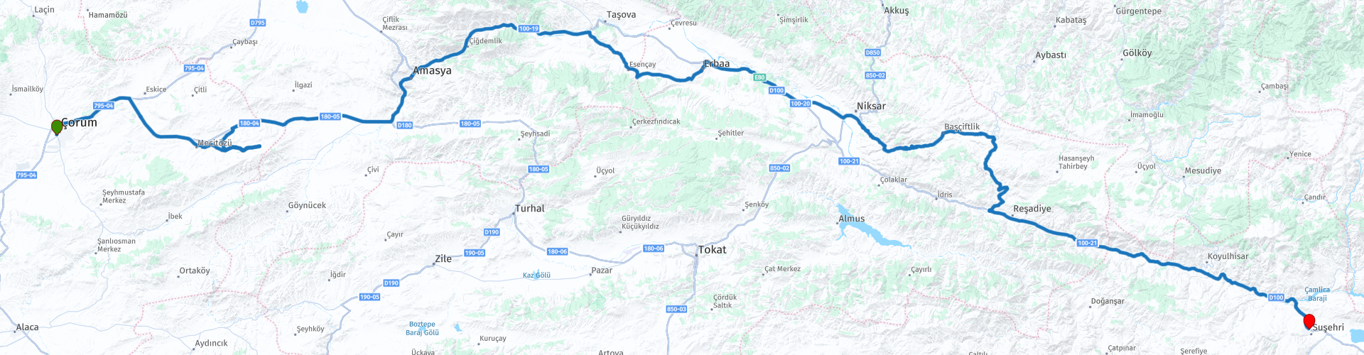
 The first long stop is planned in Amasya where we visit the Ferhat ile Şirin Lovers Museum. Here Ferhat's love for Şirin is commemorated, he brought drinking water for his beloved through the mountains of Amasya to the city center. Also shown here are the love stories of Leyla and Mecnun, Kerem and Aslı, Romeo and Juliet, Mimar Sinan and Mihrimah Sultan, and the divine love of Mevlana and Hacı Bektaş Veli.
After the museum visit, it is only a 5-minute drive to the center of Amasya, where we planned the second long stop for lunch. Along the river Yesilirmak you can relax on Ziya Paşa Boulevard. On both sides of the river are several restaurants and terraces with a great view of the river and the city. There are a number of narrow walkways over the river so find a parking space, take a walk and enjoy lunch in one of the many restaurants.
After lunch we take the highway D100/E80 to Dutluk where we leave the highway again. Despite the fact that this part of the route goes on the highway, it is still a nice drive of about 40 kilometers, the road meanders along the Yesilirmak river and the mountain Akpelit Tepes, with which you can enjoy the beautiful panorama.
In Dutluk we take the provincial road through a beautiful valley to Erbaa, optionally you can take the D100/E80 to Elbaa, if you want to make up time. In Erbaa there are several bars, cafes and restaurants where you can stop for a drink or something to eat. In Erbaa we take the highway E80 towards Günlüce, here you have two options again; follow the track through the mountains and descend to Reşadiye, or continue on the D100/E80 highway to Reşadiye, where we rejoin the original track.
From Reşadiye we drive via the highway D100/E80 to our hotel in Suşehri.


 Links
Links  Usage
Usage Want to download this route?
You can download the route for free without MyRoute-app account. To do so, open the route and click 'save as'. Want to edit this route?
No problem, start by opening the route. Follow the tutorial and create your personal MyRoute-app account. After registration, your trial starts automatically.  Disclaimer
Use of this GPS route is at your own expense and risk. The route has been carefully composed and checked by a MyRoute-app accredited RouteXpert for use on TomTom, Garmin and MyRoute-app Navigation.
Changes may nevertheless have occurred due to changed circumstances, road diversions or seasonal closures. We therefore recommend checking each route before use.
Preferably use the route track in your navigation system. More information about the use of MyRoute-app can be found on the website under 'Community' or 'Academy'.

Tokat
About this region
Tokat is the capital city of Tokat Province of Turkey in the mid-Black Sea region of Anatolia. It is located at the confluence of the Tokat River (Tokat Suyu) with the Yeşilırmak. In the 2018 census, the city of Tokat had a population of 155,000.
Read more on Wikipedia
View region
 Statistics
  1
1Amount of RX reviews (Tokat)
 255
255Amount of visitors (Tokat)
 9
9Amount of downloads (Tokat)