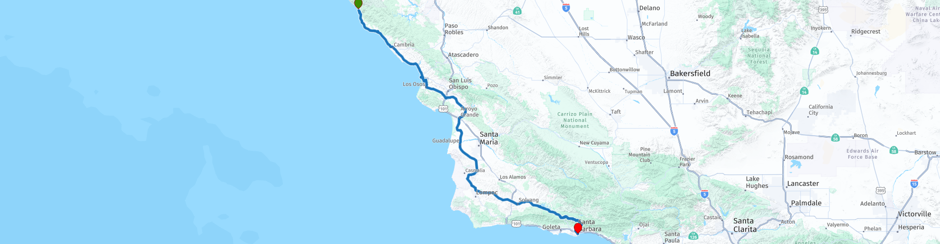
Day 124 The Ultimate USA road trip Ragged Point Santa Barbara

This route was brought to you by:
RouteXpert René Plücken (MRA Master)
Last edit: 02-04-2024
 Route Summary
 I have further supplemented the Road Trip with even more special points that you can visit in the USA. Today we drive from Ragged Point over beautiful and challenging roads to Santa Barbara. The ride is approximately 300km.
We drive along the beautiful winding Cabrillo Highway and E Camino Cielo Road. Along the way you will enjoy beautiful views, beautiful nature, there are several sights to visit and many beautiful viewpoints. I rate this route 5 stars.
 Share this route


Animation

Verdict


Duration
11h 16m

Mode of travel
Car or motorcycle

Distance
297.19 km

Countries

 RouteXpert Review
 There are several beautiful viewpoints where you can take beautiful photos, a must is the Elephant Seal Vista Point, here you can see elephant seals resting on the beach along the coastline. These elephant seals have a nose that resembles an elephant. They are available in abundance from mid-November to mid-January.
We visit the beautiful Hearst Castle, built by William Randolph Hearst. This fantastic estate on its ranch land overlooks the village of San Simeon. He named the estate "La Cuesta Encantada", Spanish for The Enchanted Hill. In 1947, the hilltop complex included a main building with two towers, three luxurious guesthouses and 127 hectares of terraced gardens, fountains and swimming pools. Take a tour and travel back in time and experience what it was like to be a guest at The Enchanted Hill.
We stop in Cayucos for a photo at the Point Estero shipwreck. Take the short walk from the parking lot to the shoreline, where you can see the fascinating shipwreck in remarkable condition. The Point Estero was a commercial fishing vessel that originated from the port of Morro Bay. Unfortunately, on July 28, 2017, on the way back to Morro Bay, it ran aground. The owner couldn't afford the cost of the salvage and it has since become a popular spot. At low tide you can walk to the wreck, but be careful when boarding because the rust makes the wreck very weak and full of holes.
We visit Morro Rock, a volcanic plug in Morro Bay. The rock is protected as the Morro Rock State Preserve. The 581-foot (177 m) Morro Rock is one of 13 volcanic plugs (remnants of extinct volcanoes), lava domes, and slab-like intrusions between Morro Bay to the north and Islay Hill to the south, all in San Luis Obispo County. The rock can be seen from afar from Highway 1.
Wine lovers can indulge themselves during this ride because we drive past several vineyards. You can visit these for tours and tastings. For example, visit the Wolff Vineyards in the picturesque Edna Valley in California. They have a tasting room (open daily from 11am to 5pm) and a gift shop. They offer wine tastings, complemented by picnic facilities in an outdoor flower garden. A Gourmet Deli is available with cheese and charcuterie platters, artisan flatbreads and specialty soft drinks. Spend the afternoon in the vineyard tasting delicious wine and enjoying fantastic panoramic views.
We drive past Vandenberg Air Force Base where Space Launch Delta 30 is housed. It supports West Coast launch activities for the Air Force, DoD, National Aeronautics and Space Administration, national programs and private sector contractors. SLD 30 launched Atlas V, Delta IV, Pegasus, Minotaur and Falcon 9. Unfortunately they do not offer tours.
We visit the town of Solvang, also known as 'Little Denmark', it is a small town with a Danish appearance. It was founded in 1911 by three Danish immigrants and today resembles a Scandinavian theme park, complete with windmills, gas lanterns, gingerbread, Carlsberg beer and a museum about Hans Christian Andersen. It is a nice stop to have a cup of coffee with a Danish cookie.
We will stop briefly at the Lake Cachuma and Bradbury Dam viewpoint, from this spot you will have a great view of the reservoir in the Santa Ynez Valley, which was created by the construction of the Bradbury Dam, a 61 meter earth-filled structure , built by the US Bureau of Reclamation in 1953. It covers an area of 1,300 hectares, with an area of 1,300 hectares. maximum design capacity of 205,000 acre⋅ft (253,000,000 m3), but this is currently limited to 188,000 acre⋅ft (232,000,000 m3) due to sediment buildup.
We drive over the Cold Spring Canyon Arch Bridge. It is currently the highest arch bridge in the US state of California and one of the highest bridges in the United States. At its highest point, the bridge deck is 400 feet (122 meters) above the canyon floor. The bridge is also the largest steel arch bridge in the state. It was determined that it would qualify for the National Register of Historic Places of Outstanding Significance.
The last part of this day we drive on the E Camino Cielo Road. Enjoy the drive along this challenging, narrow and winding road in the Santa Ynez Mountains. Camino Cielo means “Sky Road” in Spanish and there couldn't be a better name for this route, it feels like you're riding through the sky with amazing views in every direction. You will see the mountains, valleys, coastline and the city of Santa Barbara.
Santa Barbara is the end point of this beautiful day. This coastal city has a lot to offer, from arts and culture and outdoor recreation to a world-class food and wine scene with hundreds of restaurants to choose from and dozens of lively events. Whether you relax on the beach, kayak the Channel Islands, explore underground salt caverns, or browse countless art galleries, museums, and eclectic boutiques, there's plenty to do when you visit Santa Barbara.


 Links
Links  Usage
Usage Want to download this route?
You can download the route for free without MyRoute-app account. To do so, open the route and click 'save as'. Want to edit this route?
No problem, start by opening the route. Follow the tutorial and create your personal MyRoute-app account. After registration, your trial starts automatically.  Disclaimer
Use of this GPS route is at your own expense and risk. The route has been carefully composed and checked by a MyRoute-app accredited RouteXpert for use on TomTom, Garmin and MyRoute-app Navigation.
Changes may nevertheless have occurred due to changed circumstances, road diversions or seasonal closures. We therefore recommend checking each route before use.
Preferably use the route track in your navigation system. More information about the use of MyRoute-app can be found on the website under 'Community' or 'Academy'.

California
About this region
California is a state in the Western United States. It shares a border with Oregon to the north, Nevada and Arizona to the east, and the Mexican state of Baja California to the south. With over 39.5 million residents across a total area of approximately 163,696 square miles (423,970 km2), it is the most populous and the third-largest U.S. state by area. It is also the most populated subnational entity in North America and the 34th most populous in the world. The Greater Los Angeles area and the San Francisco Bay Area are the nation's second and fifth most populous urban regions respectively, with the former having more than 18.7 million residents and the latter having over 9.6 million. Sacramento is the state's capital, while Los Angeles is the most populous city in the state and the second most populous city in the country (after New York City). Los Angeles County is the country's most populous, while San Bernardino County is the largest county by area in the country. San Francisco, which is both a city and a county, is the second most densely populated major city in the country (after New York City) and the fifth most densely populated county in the country, behind four of New York City's five boroughs.
The economy of California, with a gross state product of $3.2 trillion as of 2019, is the largest sub-national economy in the world. If it were a country, it would be the 37th most populous country and the fifth largest economy as of 2020. The Greater Los Angeles area and the San Francisco Bay Area are the nation's second- and third-largest urban economies ($1.0 trillion and $0.5 trillion respectively as of 2020), after the New York metropolitan area ($1.8 trillion). The San Francisco Bay Area Combined Statistical Area had the nation's highest gross domestic product per capita ($106,757) among large primary statistical areas in 2018, and is home to five of the world's ten largest companies by market capitalization and four of the world's ten richest people.Prior to European colonization, California was one of the most culturally and linguistically diverse areas in pre-Columbian North America and contained the highest Native American population density north of what is now Mexico. European exploration in the 16th and 17th centuries led to the colonization of California by the Spanish Empire. In 1804, it was included in Alta California province within the Viceroyalty of New Spain. The area became a part of Mexico in 1821, following its successful war for independence, but was ceded to the United States in 1848 after the Mexican–American War. The western portion of Alta California was then organized and admitted as the 31st state on September 9, 1850, following the Compromise of 1850. The California Gold Rush started in 1848 and led to dramatic social and demographic changes, including large-scale immigration into California, a worldwide economic boom, and the California genocide of indigenous people.
Notable contributions to popular culture, for example in entertainment and sports, have their origins in California. The state also has made noteworthy contributions in the fields of communication, information, innovation, environmentalism, economics, and politics. It is the home of Hollywood, the oldest and largest film industry in the world, which has had a profound effect on global entertainment. It is considered the origin of the hippie counterculture, beach and car culture, and the personal computer, among other innovations. The San Francisco Bay Area and the Greater Los Angeles Area are widely seen as centers of the global technology and entertainment industries, respectively. California's economy is very diverse: 58% of it is based on finance, government, real estate services, technology, and professional, scientific, and technical business services. Although it accounts for only 1.5% of the state's economy, California's agriculture industry has the highest output of any U.S. state. California's ports and harbors handle about a third of all U.S. imports, most originating in Pacific Rim international trade.
The state's extremely diverse geography ranges from the Pacific Coast and metropolitan areas in the west to the Sierra Nevada mountains in the east, and from the redwood and Douglas fir forests in the northwest to the Mojave Desert in the southeast. The Central Valley, a major agricultural area, dominates the state's center. Although California is well known for its warm Mediterranean climate and monsoon seasonal weather, the large size of the state results in climates that vary from moist temperate rainforest in the north to arid desert in the interior, as well as snowy alpine in the mountains. All these factors lead to an enormous demand for water. Over time, droughts and wildfires have increased in frequency and become less seasonal and more year-round, further straining California's water security.
Read more on Wikipedia
The economy of California, with a gross state product of $3.2 trillion as of 2019, is the largest sub-national economy in the world. If it were a country, it would be the 37th most populous country and the fifth largest economy as of 2020. The Greater Los Angeles area and the San Francisco Bay Area are the nation's second- and third-largest urban economies ($1.0 trillion and $0.5 trillion respectively as of 2020), after the New York metropolitan area ($1.8 trillion). The San Francisco Bay Area Combined Statistical Area had the nation's highest gross domestic product per capita ($106,757) among large primary statistical areas in 2018, and is home to five of the world's ten largest companies by market capitalization and four of the world's ten richest people.Prior to European colonization, California was one of the most culturally and linguistically diverse areas in pre-Columbian North America and contained the highest Native American population density north of what is now Mexico. European exploration in the 16th and 17th centuries led to the colonization of California by the Spanish Empire. In 1804, it was included in Alta California province within the Viceroyalty of New Spain. The area became a part of Mexico in 1821, following its successful war for independence, but was ceded to the United States in 1848 after the Mexican–American War. The western portion of Alta California was then organized and admitted as the 31st state on September 9, 1850, following the Compromise of 1850. The California Gold Rush started in 1848 and led to dramatic social and demographic changes, including large-scale immigration into California, a worldwide economic boom, and the California genocide of indigenous people.
Notable contributions to popular culture, for example in entertainment and sports, have their origins in California. The state also has made noteworthy contributions in the fields of communication, information, innovation, environmentalism, economics, and politics. It is the home of Hollywood, the oldest and largest film industry in the world, which has had a profound effect on global entertainment. It is considered the origin of the hippie counterculture, beach and car culture, and the personal computer, among other innovations. The San Francisco Bay Area and the Greater Los Angeles Area are widely seen as centers of the global technology and entertainment industries, respectively. California's economy is very diverse: 58% of it is based on finance, government, real estate services, technology, and professional, scientific, and technical business services. Although it accounts for only 1.5% of the state's economy, California's agriculture industry has the highest output of any U.S. state. California's ports and harbors handle about a third of all U.S. imports, most originating in Pacific Rim international trade.
The state's extremely diverse geography ranges from the Pacific Coast and metropolitan areas in the west to the Sierra Nevada mountains in the east, and from the redwood and Douglas fir forests in the northwest to the Mojave Desert in the southeast. The Central Valley, a major agricultural area, dominates the state's center. Although California is well known for its warm Mediterranean climate and monsoon seasonal weather, the large size of the state results in climates that vary from moist temperate rainforest in the north to arid desert in the interior, as well as snowy alpine in the mountains. All these factors lead to an enormous demand for water. Over time, droughts and wildfires have increased in frequency and become less seasonal and more year-round, further straining California's water security.
View region
 Statistics
  43
43Amount of RX reviews (California)
 29460
29460Amount of visitors (California)
 768
768Amount of downloads (California)
 Route Collections in this region
 Car or motorcycle tour through the western US
This collection contains all 15 routes driven by MRA Goldmember André ter Schegget during his three-week tour through the west of America.
The places to visit, the attractions and beautiful photo spots are nicely marked on the routes. The routes have been fully checked and made equal for the Garmin and the TomTom. Enjoy this wonderful trip and let us know how it was! Enjoy and stay safe!
Order of the tour:
Route 01: from Los Angeles and via Pacific Coast Highway to Solvang
Route 02: Solvang to Monterey / Pacific Grove
Route 03A: Monterey to San Francisco
Route 03B: if you are by car instead of the motorcycle, as motorcycles are not allowed on the 17 Mile Drive: from Monterey to the 17 Mile Drive and further to San Francisco
Route 04: from San Francisco via Nappa and Eldorado National Forrest to Topaz Lake
Route 05: from Topaz Lake via Bodie and Yosemite to Oakhurst
Route 06: from Oakhurst via Kings Canyon NP and Sequoia NP and Giant Forest to Exeter
Route 07: Exeter via Isabella Lake and Ridgecrest to Death Valley
Route 08: from Death Valley via Valley Of Fire to Mesquite
Route 09: from Mesquite via Zion NP and Dixie NF to Hatch
Route 10: Hatch via Bryce Canyon to Page
Route 11: from Page via Grand Canyon to Williams
Route 12: from Williams via Seligman and Route 66 to Kingman and via Hoover Dam to Las Vegas
Route 13: from Las Vegas via Oatman and Lake Havasu to Parker
Route 14: from Parker via Joshua Tree to Rancho Mirage
Route 15: Rancho Mirage via Palm Springs to Santa Monica
View Route Collection
The 10 most downloaded routes in the USA from RouteXpert Hans van de Ven
Hello and welcome to this collection of the Top 10 MyRoute app downloaded routes in USA.
There will be a great new event to be announced soon, where all these routes can be driven.
Download them all now and place them in a new "Top 10" folder, so that you always have them at hand.
If you are going to drive one of these routes in the meantime, track them with the MRA Mobile App or with MRA Navigation. Take some photos (moments) along the way as these will come in handy.
Create a travelogue of your Top 10 driven routes and add the recorded track to it.
There will also be some great prizes on offer, so keep an eye on the MRA-RouteXperts page and your mail.
The 10 routes are:
1. D13 Estes Park Denver
2. D03 Chadron Custer
3. D01 Pigeon Forge round trip through the Smokey Mountains
4. D08 Kalispell Sandpoint
5. D10 Colville Wenatchee
6. D09 Sandpoint Colville
7. D04 Custer Wall
8. D11 Wenatchee Seattle
9. D08 Cody Yellowstone NP
10.R13 San Francisco Monterey
View Route Collection