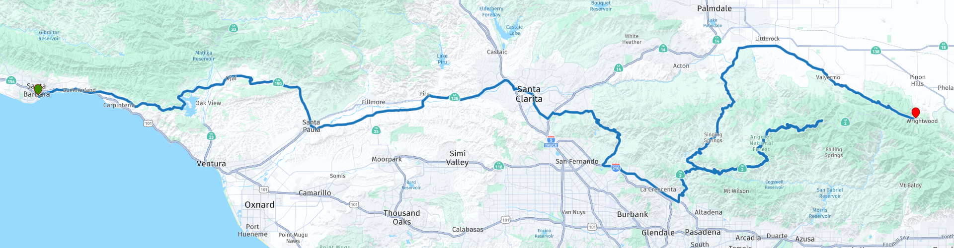
Day 125 The Ultimate USA road trip Santa Barbara Wrightwood

Diese Route wurde erstellt von:
RouteXpert René Plücken (MRA Master)
Letzte Änderung: 03-04-2024
 Routenzusammenfassung
 Ich habe den Road Trip noch um weitere besondere Punkte ergänzt, die du in den USA besuchen kannst. Heute fahren wir von Santa Barbara nach Wrightwood. Die Fahrt ist fast 290 km lang.
Wir fahren auf wunderschönen Scenic Byways durch das wunderschöne bergige Kalifornien. Unterwegs gibt es Sehenswürdigkeiten zu besichtigen und viele schöne Aussichtspunkte. Es gibt ein paar Autobahnabschnitte, aber ich bewerte diese Route trotzdem mit 5 Sternen.
 Diese Route teilen


Animation

Urteil


Dauer
8h 58m

Reisemodus
Auto oder Motorrad

Entfernung
289.94 km

Länder

 RouteXpert-Überprüfung
 Auf unserem Weg durch Santa Barbara kommen wir am „Carousel House“ vorbei, das 20 Jahre lang ein Karussell beherbergte und nun in einen offenen Raum mit gewächshausartigem Industrieambiente umgewandelt wurde, der sich perfekt für Veranstaltungen aller Art eignet. Der Rasen des Chase Palm Park Plaza mit einem bepflanzten Springbrunnen ist im Mietpreis des Carousel House enthalten.
Etwas weiter halten wir kurz an, um ein Foto am „Santa Barbara Chromatic Gate“ zu machen. Dieser 1991 erbaute „Regenbogenbogen“ hat eine Höhe von 6 Metern und ein Gewicht von 12,5 Tonnen. Das „Santa Barbara Chromatic Gate“ hat sechs verschiedene Farben, wobei ein Bogen etwas größer als der andere ist, um ein Regenbogentor zu schaffen. Es wurde vom berühmten in Österreich geborenen Künstler Herbert Bayer entworfen und ist ein beliebter Ort zum Fotografieren.
Wir verlassen die Stadt und fahren entlang der Berge zum Lake Casitas, diesem Stausee im kalifornischen Ventura County, der vom US Bureau of Reclamation gebaut und 1959 fertiggestellt wurde. Das Projekt liefert Trinkwasser und Wasser für die Bewässerung. Ein zweiter Vorteil ist der Hochwasserschutz. Während der Olympischen Sommerspiele 1984 wurde hier Kanu- und Rudersport betrieben. Der Casitas Dam wurde am Coyote Creek zwei Meilen vor seiner Mündung in den Ventura River gebaut. Am Lake Casitas Viewpoint hat man einen wunderschönen Blick auf den Stausee.
Wir setzen unsere Fahrt nach Ojai fort, das im Ojai-Tal liegt. Als Teil der von Ost nach West verlaufenden Western Transverse Ranges ist das Tal etwa 16 km lang und 5 km breit und in ein unteres und ein oberes Tal von jeweils ähnlicher Größe unterteilt, die von Hügeln und Hügeln umgeben sind Berge. Ojai ist bekannt für seine Boutique-Hotels, Freizeitmöglichkeiten, Wandermöglichkeiten und den Bauernmarkt für lokalen Bio-Anbau.
Es gibt kleine Unternehmen, die sich auf lokale und umweltfreundliche Kunst, Design und Heimwerkerarbeiten spezialisiert haben. Filialisten sind per Stadtverordnung verboten, um die Entwicklung lokaler Kleinunternehmen zu fördern und den Charakter der Stadt zu bewahren. Der Name Ojai leitet sich vom Rancho Ojai aus der mexikanischen Ära ab, das wiederum seinen Namen vom Ventureño Chumash-Wort „Awha'y“ erhielt, was „Mond“ bedeutet. Der selbsternannte Spitzname der Stadt lautet „Shangri-La“ und bezieht sich auf die natürliche Umgebung dieser auf Gesundheit und Spiritualität ausgerichteten Region sowie auf den mystischen Rückzugsort aus der Verfilmung von James Hiltons Roman „Lost Horizon“ aus dem Jahr 1937. Ein kurzer Stopp lohnt sich.
Etwas außerhalb der Stadt halten wir an einem Aussichtspunkt in Ojai. Er bietet einen perfekten Blick auf das Ojai-Tal und ein Panorama auf die wunderschönen Berge. Auf der rechten Seite befindet sich eine großzügige Einfahrt zum Parken.
Wir fahren über den wunderschönen Anlauf Canyon nach Santa Paula. Hier können Sie eine Railbike-Tour mit Sunburst Railbikes in Betracht ziehen. Erkunden Sie die landschaftliche Schönheit Südkaliforniens wie nie zuvor auf einem einzigartigen, tretbetriebenen (und elektrisch unterstützten) Zwei-Personen-Fahrrad, das auf Schienen durch die Landschaft fährt.
Genießen Sie eine Tour durch die Zitrus- und Avocadohaine von Ventura County. Picknick-Mittagessen können erworben werden und es bleibt Zeit für ein schönes Picknick. Die Railbikes sind für jedes Alter geeignet und eine perfekte Möglichkeit, den Tag im Freien zu verbringen: aktiv und aufregend, aber gleichzeitig entspannend und lässig. Wochenendpreis: 249 $ pro Fahrrad für zwei Personen. Die Tour dauert 2 Stunden und ist 10 Meilen lang.
Santa Paula ist die Heimat von „The Warning“, der berühmten Statue zweier Motorradpolizisten, die 1928 durch Santa Paula rasten, um die Bevölkerung vor dem Einsturz des St. Francis Dam zu warnen. Die Statue an der Ecke 10th Street und Santa Barbara Street stellt den State Motor Officer Thornton Edwards und den Santa Paula Police Officer Stanley Baker in der Nacht der Katastrophe dar.
Nach einer etwa 50-minütigen Fahrt entlang des Santa Clara River überqueren wir ihn, um das Rancho Camulos zu besuchen, das heute als Rancho Camulos Museum bekannt ist. Diese Ranch an der State Route 126 im Santa Clara River Valley war im 19. Jahrhundert die Heimat von Ygnacio del Valle, einem kalifornischen Alcalde aus dem Pueblo de Los Angeles, der später in die California State Assembly gewählt wurde.
Die Ranch war als Ramonas Haus bekannt, da allgemein angenommen wurde, dass sie der Schauplatz von Helen Hunt Jacksons populärem Roman Ramona aus dem Jahr 1884 war. Der Roman trug dazu bei, das Bewusstsein für den kalifornischen Lebensstil zu schärfen und romantisierte „die Mission- und Rancho-Ära der kalifornischen Geschichte“.
Die 7 km2 große Ranch ist ein gutes Beispiel für eine frühe kalifornische Ranch in ihrer ursprünglichen ländlichen Umgebung. Es war die Quelle der ersten kommerziell angebauten Orangen im Ventura County. Es ist einer der wenigen verbliebenen Zitrusanbauer in Südkalifornien.
Die State Route 126 durchschneidet das Grundstück, wobei die meisten Hauptgebäude südlich der Autobahn und einige Gebäude nördlich liegen. Der Hauptziegel ist eines der wenigen erhaltenen Gebäude aus der spanischen Kolonialzeit im Bundesstaat. Die meisten anderen Gebäude sind im Mission-Revival- oder Spanisch-Kolonial-Revival-Stil gehalten, die beide vom Original abgeleitet sind.
Rancho Camulos ist als National Historic Landmark ausgewiesen, im National Register of Historic Places aufgeführt und außerdem als California Historic Landmark ausgewiesen. Viele der Gebäude und Anlagen sind als Museen aus dieser Zeit der kalifornischen Geschichte für die Öffentlichkeit zugänglich.
Wir verlassen die Autobahn in Valencia, wo wir zum Mittagessen anhalten und wo Sie einen Besuch des Six Flags Magic Mountain planen können. Der Vergnügungspark ist einer der bekanntesten Six Flags Parks und der einzige Park, der das ganze Jahr über geöffnet ist. Seit 2012 hält der Park den Rekord für die meisten Achterbahnen (20) in einem Vergnügungspark.
Wenn wir Valencia verlassen, beginnt der Spaß erst richtig mit einer Reihe malerischer Nebenstraßen durch die Berge des Angeles National Forest.
Der erste Scenic Byway ist die Placerita Canyon Road, die von Newhall zur Sand Canyon Road führt. Jenseits des Sierra Highway wird die Schlucht tiefer und bietet wunderschöne Ausblicke auf die westlichen San Gabriel Mountains. Einer der ersten großen Goldfunde fand hier im Jahr 1842 an der „Eiche des Goldenen Traums“ in der Nähe der Disney Ranch statt.
Der nächste Scenic Byway ist die Sand Canyon Road, die größtenteils in den 1930er Jahren gebaut wurde. Diese Straße folgt dem westlichen Ende der San Gabriel Mountains. Sie verläuft vom Sierra Highway bis zur Kreuzung der Little Tujunga Canyon Road bei Bear Divide, wo man von einem Parkplatz aus einen wunderschönen Blick auf die Sand Canyon Road hat.
An diesem Parkplatz beginnt die „Little Tujunga Canyon Road“. Diese kurvenreiche Straße mit schöner Aussicht verläuft von Bear Divide auf der Sand Canyon Road bis zum Foothill Boulevard in Lakeview Terrace. Fast alles davon liegt im Angeles National Forest. Der größte Teil dieser Straße wurde Mitte der 1930er Jahre vom California Conservation Corps gebaut.
Und dann ist der Höhepunkt des Tages der „Angeles Crest Scenic Highway“, der von La Cañada-Flintridge zum Mountain Top-Verkehrsknotenpunkt an der SR138 führt. Das Konzept für die landschaftlich schönste und malerischste Bergstraße des Staates wurde 1912 entwickelt und die Finanzierung begann 1919. Der Bau begann schrittweise im Jahr 1929 und dauerte bis 1956, mit Ausnahme der Jahre 1941 bis 1946 während des Zweiten Weltkriegs.
Der „Angeles Crest Scenic Highway“ erreicht eine Höhe von 8.000 Fuß und schlängelt sich durch 66 Meilen des Angeles National Forest, durch wunderschönes Grün aus Sträuchern und Wäldern, entlang der höchsten und malerischsten Bergrücken der San Gabriel-Bergkette.
Der „Angeles Crest Scenic Highway“, der mehrere Jahre wegen Erdrutschen gesperrt war, wurde am 20. Mai 2009 repariert und wiedereröffnet und erstreckt sich nun bis zur Stadt Wrightwood, auch dem Endpunkt dieses schönen Tages. Die Nacht verbringen wir im Applewood Inn.


 Links
Links  Nutzung
 Möchten Sie diese Route herunterladen?
Sie können die Route ohne MyRoute-App-Konto kostenlos herunterladen. Öffnen Sie dazu die Route und klicken Sie auf 'Speichern unter'. Möchten Sie diese Route bearbeiten?
Kein Problem, starten Sie mit dem Öffnen der Route. Folgen Sie dem Tutorial und erstellen Sie Ihr persönliches MyRoute-App-Konto. Nach der Registrierung startet Ihre Testversion automatisch.  Haftungsausschluss
Die Nutzung dieser GPS-Route erfolgt auf eigene Kosten und Gefahr. Die Route wurde sorgfältig von einem MyRoute-App akkreditierten RouteXpert für die Verwendung mit TomTom, Garmin und MyRoute-App Navigation zusammengestellt und geprüft.
Durch geänderte Umstände, Straßenumleitungen oder saisonale Sperren können sich dennoch Änderungen ergeben haben. Wir empfehlen daher, jede Route vor der Nutzung zu überprüfen.
Verwenden Sie vorzugsweise den Routentrack in Ihrem Navigationssystem. Mehr Informationen zu den Die Nutzung der MyRoute-App finden Sie auf der Website unter 'Community' oder 'Academy'.

Kalifornien
Über diese Region
Kalifornien (englisch [kælɪˈfɔɹnjə] und spanisch California [kaliˈfoɾnja]) ist ein Bundesstaat der Vereinigten Staaten. Er ist der flächenmäßig drittgrößte und mit Abstand bevölkerungsreichste Bundesstaat. Kalifornien liegt im Westen des Landes und grenzt an den Pazifischen Ozean, die Bundesstaaten Oregon, Nevada und Arizona sowie den mexikanischen Bundesstaat Baja California auf der gleichnamigen Halbinsel. Der offizielle Beiname Kaliforniens lautet Golden State (Goldener Staat).
Lesen Sie mehr auf Wikipedia
Region anzeigen
 Statistik
  43
43Anzahl der RX-Bewertungen (Kalifornien)
 29725
29725Anzahl der Besucher (Kalifornien)
 768
768Anzahl der Downloads (Kalifornien)
 Routensammlungen in dieser Region
 Auto- oder Motorradtour durch den Westen der USA
Diese Sammlung enthält alle 15 Routen, die MRA Goldmember André ter Schegget während seiner dreiwöchigen Tour durch den Westen Amerikas gefahren ist.
Die Ausflugsziele, Sehenswürdigkeiten und schönen Fotospots sind auf den Routen gut markiert. Die Routen wurden vollständig überprüft und für Garmin und TomTom gleichgestellt. Genießen Sie diese wundervolle Reise und lassen Sie uns wissen, wie es war! Genießen Sie und bleiben Sie sicher!
Reihenfolge der Tour:
Route 01: von Los Angeles und über den Pacific Coast Highway nach Solvang
Route 02: Solvang nach Monterey / Pacific Grove
Route 03A: Monterey nach San Francisco
Route 03B: Wenn Sie mit dem Auto statt mit dem Motorrad unterwegs sind, da Motorräder auf dem 17 Mile Drive nicht erlaubt sind: von Monterey zum 17 Mile Drive und weiter nach San Francisco
Route 04: von San Francisco über Nappa und Eldorado National Forrest zum Topaz Lake
Route 05: vom Topaz Lake über Bodie und Yosemite nach Oakhurst
Route 06: von Oakhurst über Kings Canyon NP und Sequoia NP und Giant Forest nach Exeter
Route 07: Exeter über Isabella Lake und Ridgecrest zum Death Valley
Route 08: vom Death Valley über Valley Of Fire nach Mesquite
Route 09: von Mesquite über Zion NP und Dixie NF nach Hatch
Route 10: Hatch über den Bryce Canyon nach Page
Route 11: von Page über den Grand Canyon nach Williams
Route 12: von Williams über Seligman und Route 66 nach Kingman und über den Hoover Dam nach Las Vegas
Route 13: von Las Vegas über Oatman und Lake Havasu nach Parker
Route 14: von Parker über Joshua Tree nach Rancho Mirage
Route 15: Rancho Mirage über Palm Springs nach Santa Monica
Routensammlung anzeigen
Die 10 am häufigsten heruntergeladenen Routen in den USA von RouteXpert Hans van de Ven
Hallo und willkommen zu dieser Sammlung der Top 10 MyRoute App heruntergeladenen Routen in den USA.
In Kürze wird eine großartige neue Veranstaltung angekündigt, bei der alle diese Routen gefahren werden können.
Laden Sie sie jetzt alle herunter und legen Sie sie in einem neuen "Top 10" -Ordner ab, damit Sie sie immer zur Hand haben.
Wenn Sie in der Zwischenzeit eine dieser Routen fahren, verfolgen Sie sie mit der MRA Mobile App oder mit MRA Navigation. Machen Sie unterwegs einige Fotos (Momente), da diese nützlich sein werden.
Erstellen Sie einen Reisebericht Ihrer Top 10 gefahrenen Routen und fügen Sie den aufgezeichneten Track hinzu.
Es werden auch einige tolle Preise angeboten. Behalten Sie also die MRA-RouteXperts-Seite und Ihre E-Mails im Auge.
Die 10 Routen sind:
1. D13 Estes Park Denver
2. D03 Chadron Custer
3. D01 Pigeon Forge Rundreise durch die Smokey Mountains
4. D08 Kalispell Sandpoint
5. D10 Colville Wenatchee
6. D09 Sandpoint Colville
7. D04 Custer Wall
8. D11 Wenatchee Seattle
9. D08 Cody Yellowstone NP
10.R13 San Francisco Monterey
Routensammlung anzeigen