Day 98 The Ultimate USA road trip Hot Springs Custer

This route was brought to you by:
RouteXpert René Plücken (MRA Master)
Last edit: 19-12-2023
 Route Summary
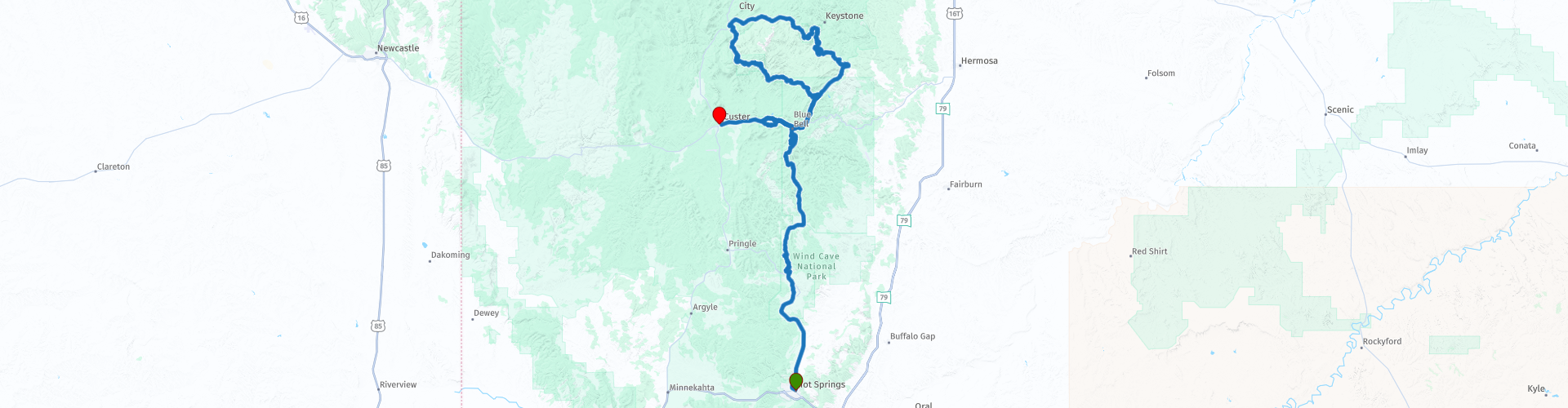
 I have further supplemented the Road Trip with even more special points that you can visit in the USA. Today we drive from Hot Springs through the Black Hills to Custer. It is a great ride of just over 170 kilometers.
We drive on beautiful mountain roads through the Black Hills with beautiful “Scenic Highways”. This is a beautiful route with many stops to enjoy the view, the highlight of this day is Mount Rushmore. I rate this route 5 stars.
 Share this route


Animation

Verdict


Duration
8h 48m

Mode of travel
Car or motorcycle

Distance
157.80 km

Countries

 RouteXpert Review
 The route is a series of beautiful winding roads through stunning natural beauty, along the way we pass several viewpoints where you can stop to enjoy the view and take photos. Along the route we also pass lakes and rivers that we sometimes cross on beautiful bridges, such as the “Beaver Creek Bridge” in the “Wind Cave Park”, a deck arch bridge built of concrete and steel. It is 69 meters long and is located 35 meters above the canyon floor. The purpose of building the bridge in 1929 was to provide travelers with more convenient access to the newly developed Custer State Park north of Wind Cave National Park.
One of the key achievements of the bridge's builders was to create the illusion of the concrete arches rising naturally from the rock walls on either side of the gorge. The nature of this bridge makes it historically important. It is the only bridge of this specific arch type in the state of South Dakota. It is also only one of three "major bridges" in the Rocky Mountain Region of the National Park System. The construction of this bridge was made possible through the efforts of Peter Norbeck, the U.S. Senator from South Dakota.
From the “Wind Cave Park” drive into “Custer State Park”, the park is open all year round, 24 hours a day, some roads may be closed in the winter, such as “The Needles Highway”. It is best to buy a day pass online for $8. At the park entrances it costs $20 per vehicle for 1-7 days. An annual park access license costs $36 and you can purchase a second annual park access license for $18.
We leave early and also take enough food and drinks for the journey. The first stop is at the Wind Cave National Park Visitors Center to learn more about this beautiful park. Wind Cave National Park is a national park in the United States, eighteen kilometers north of the town of Hot Springs in the western state of South Dakota. Located in the Black Hills, the park was founded in 1903 by President Theodore Roosevelt and was the seventh national park in the United States and the first cave designated as a national park in the world.
The park includes a large nature reserve with a cave system of 219 kilometers long. The cave system is the third longest in the United States. The nature reserve consists mainly of prairie and provides living space for large herds of bison, as well as ferrets, wapitis, antelopes and various types of rodents.
Wind Cave is known for its unique limestone cave formations, including “boxwork,” a rare type of carved pattern not found to this extent anywhere else in the world. The Wind Cave cave is also known for the strong air current, which gives it its name. When the pressure outside is higher than inside, the air is sucked in. When the pressure inside the cave is higher, the wind blows outside. The wind can reach a speed of eighty kilometers per hour.
Wind Cave is also known for its frostwork. The cave is considered a three-dimensional maze. The cave surpassed Switzerland's Hoelloch Cave on February 11, 2006, becoming the fourth longest cave in the world with 192 kilometers of explored cave passages. Above ground, the park contains the largest remaining naturally mixed grass prairie in the United States.
We drive over the beautiful Beaver Creek Bridge into Custer State Park, along the route there are many parking lots with places where you can take beautiful photos. We will stop at Stop at the “Mount Coolidge Lookout” the highest point in Custer State Park, where the “Fire Tower” is located, this was one of the last projects completed by the Civilian Conservation Corps in the late 1930s. The tower is built of local stone and rests atop a peak of 1835 meters. The tower is still used as a fire lookout and as an alarm center. As the highest point, it offers breathtaking 360-degree views from the top of the fire tower. On a clear day you can see the Badlands almost 60 miles away to the east.
We drive around Stockade Lake, the largest of the five lakes of Custer State Park. Stockade is the only lake in Custer State Park that accommodates all types of boats. This beautiful lake also features a swimming beach, walking trail, playground, group area and fishing opportunities. Stockade Lake is also near some Black Hills historical sites, such as the Gordon Stockade (the next stop) and the site of the first gold discovery in the Black Hills.
At the lake we start our drive on the US-16-A Iron Mountain Road, an incredibly beautiful drive and unforgettable experience. It is one of the most unusual and fascinating roads in America. This road in the Black Hills offers the beauty of the mountains and valleys as a backdrop. This road was specifically designed for enjoying the beauty of the Black Hills. It is 17 miles (27 kilometers), with 314 turns, 14 switchbacks, 3 pigtails, 3 tunnels, 2 forks and of course the 4 presidents on Mt. Rushmore. The route is designed so that you can see Mount Rushmore from several points. It takes at least 45 minutes to navigate this road. It is designed to go slow enjoy the ride, smell the pine trees and unfortunately the buffalo, you won't find another road like this in America.
With the beauty of the mountains and valleys as a backdrop, this road was specially designed with an enormous amount of curves, including hairpin bends, to limit travelers' speed to 55 km per hour so they could enjoy the beauty of the Black Hills. What makes this road so unique and memorable is not only the amount of curves and the surrounding beauty, but also the architectural features found along this road. These features include wooden structures called pigtail bridges and single-lane tunnels built to display the American patriotic symbol, Mount Rushmore. These tunnels frame the Mount Rushmore National Memorial like a picture frame and are a spectacular place, depending on which direction you travel, you may have to look in your rear view mirror to experience this wonder.
During this 17-mile journey, you will experience not only the architectural wonders of this road, but also the wonders of Mother Nature. Don't be surprised if you are stopped in the middle of a herd of buffalo as they cross the road, grazing and tending to their young. Take some time to look around, you'll likely see antelope, deer and turkey, or you might even spot bighorn sheep or a mountain lion. Every journey along this road will be a different experience. To experience everything the road has to offer, you'll have to travel it in both directions; you will see and experience different things in every way.
We stop regularly to take photos and enjoy the beautiful view. The first stop is at Gordon Stockade, a replica of a wooden fort built by the Gordon Party to protect against Lakota attacks during the gold rush of 1874. The current Gordon Stockade was built on the original site. Meaningful signs tell the story of this short-lived illegal occupation in 1874-1875.
We stop at the three tunnels carved into the rock, each framing Mount Rushmore in a unique way. The first is the Scovel Jones Tunnel, the second is the CC Gideon Tunnel and the last is the Doane Robinson Tunnel there are no actual parking spaces to stop at but there are wide pull outs where you can get to the south side of the tunnel stopping to take pictures. Watch out for other traffic. You can't stop at the Pigtails.
Highlights of the Iron Mountain Road include Mt. Rushmore National Memorial with the Majestic figures of George Washington, Thomas Jefferson, Theodore Roosevelt and Abraham Lincoln, surrounded by the beauty of the Black Hills of South Dakota, tell the story of the birth, growth, development and preservation of this country. From the history of the first inhabitants to the diversity of America today, Mount Rushmore brings visitors face to face with America's rich heritage.
After Mount Rushmore we drive on the Needles Highway, part of South Dakota Highway 87 (SD 87). The Needles Highway runs through Wind Cave National Park and is 14 miles (23 km) long and has beautiful views and some narrow tunnels carved into the rock. There are a number of beautiful points to stop along the route.
The end point of this great day is in the town of Custer, the center of the Black Hills. It is an option to plan a few extra days and drive beautiful routes from Custer or undertake other activities.


 Links
Links  Usage
Usage Want to download this route?
You can download the route for free without MyRoute-app account. To do so, open the route and click 'save as'. Want to edit this route?
No problem, start by opening the route. Follow the tutorial and create your personal MyRoute-app account. After registration, your trial starts automatically.  Disclaimer
Use of this GPS route is at your own expense and risk. The route has been carefully composed and checked by a MyRoute-app accredited RouteXpert for use on TomTom, Garmin and MyRoute-app Navigation.
Changes may nevertheless have occurred due to changed circumstances, road diversions or seasonal closures. We therefore recommend checking each route before use.
Preferably use the route track in your navigation system. More information about the use of MyRoute-app can be found on the website under 'Community' or 'Academy'.

South Dakota
About this region
South Dakota (Sioux: Dakȟóta itókaga) is a U.S. state in the upper Midwestern United States. It is named after the Lakota and Dakota Sioux Native American tribes, who comprise a large portion of the population with nine reservations currently in the state and have historically dominated the territory. South Dakota is the seventeenth largest by area, but the 5th least populous, and the 5th least densely populated of the 50 United States. As the southern part of the former Dakota Territory, South Dakota became a state on November 2, 1889, simultaneously with North Dakota. They are the 39th and 40th states admitted to the union; President Benjamin Harrison shuffled the statehood papers before signing them so that no one could tell which became a state first. Pierre is the state capital, and Sioux Falls, with a population of about 187,200, is South Dakota's largest city.
South Dakota is bordered by the states of North Dakota (to the north), Minnesota (to the east), Iowa (to the southeast), Nebraska (to the south), Wyoming (to the west), and Montana (to the northwest). The state is bisected by the Missouri River, dividing South Dakota into two geographically and socially distinct halves, known to residents as "East River" and "West River".Eastern South Dakota is home to most of the state's population, and the area's fertile soil is used to grow a variety of crops. West of the Missouri River, ranching is the predominant agricultural activity, and the economy is more dependent on tourism and defense spending. Most of the Native American reservations are in West River. The Black Hills, a group of low pine-covered mountains sacred to the Sioux, is in the southwest part of the state. Mount Rushmore, a major tourist destination, is there. South Dakota has a temperate continental climate, with four distinct seasons and precipitation ranging from moderate in the east to semi-arid in the west. The state's ecology features species typical of a North American grassland biome.
Humans have inhabited the area for several millennia, with the Sioux becoming dominant by the early 19th century. In the late 19th century, European-American settlement intensified after a gold rush in the Black Hills and the construction of railroads from the east. Encroaching miners and settlers triggered a number of Indian wars, ending with the Wounded Knee Massacre in 1890. Key events in the 20th century included the Dust Bowl and Great Depression, increased federal spending during the 1940s and 1950s for agriculture and defense, and an industrialization of agriculture that has reduced family farming.
While several Democrats have represented South Dakota for multiple terms in both chambers of Congress, the state government is largely controlled by the Republican Party, whose nominees have carried South Dakota in each of the last 13 presidential elections. Historically dominated by an agricultural economy and a rural lifestyle, South Dakota has recently sought to diversify its economy in areas to attract and retain residents. South Dakota's history and rural character still influence strongly the state's culture.
Read more on Wikipedia
South Dakota is bordered by the states of North Dakota (to the north), Minnesota (to the east), Iowa (to the southeast), Nebraska (to the south), Wyoming (to the west), and Montana (to the northwest). The state is bisected by the Missouri River, dividing South Dakota into two geographically and socially distinct halves, known to residents as "East River" and "West River".Eastern South Dakota is home to most of the state's population, and the area's fertile soil is used to grow a variety of crops. West of the Missouri River, ranching is the predominant agricultural activity, and the economy is more dependent on tourism and defense spending. Most of the Native American reservations are in West River. The Black Hills, a group of low pine-covered mountains sacred to the Sioux, is in the southwest part of the state. Mount Rushmore, a major tourist destination, is there. South Dakota has a temperate continental climate, with four distinct seasons and precipitation ranging from moderate in the east to semi-arid in the west. The state's ecology features species typical of a North American grassland biome.
Humans have inhabited the area for several millennia, with the Sioux becoming dominant by the early 19th century. In the late 19th century, European-American settlement intensified after a gold rush in the Black Hills and the construction of railroads from the east. Encroaching miners and settlers triggered a number of Indian wars, ending with the Wounded Knee Massacre in 1890. Key events in the 20th century included the Dust Bowl and Great Depression, increased federal spending during the 1940s and 1950s for agriculture and defense, and an industrialization of agriculture that has reduced family farming.
While several Democrats have represented South Dakota for multiple terms in both chambers of Congress, the state government is largely controlled by the Republican Party, whose nominees have carried South Dakota in each of the last 13 presidential elections. Historically dominated by an agricultural economy and a rural lifestyle, South Dakota has recently sought to diversify its economy in areas to attract and retain residents. South Dakota's history and rural character still influence strongly the state's culture.
View region
 Statistics
  10
10Amount of RX reviews (South Dakota)
 10950
10950Amount of visitors (South Dakota)
 135
135Amount of downloads (South Dakota)
 Route Collections in this region
 Top car and motorcycle tour through the Midwest of the USA
By car or motorcycle through the Midwest of America is a journey that you do not just make, so it is not a 13-day drive and then back home. No, book a stay of several days in Denver, Cheyenne, Rapid City (In August the Sturgis Bike Ralley, stay there for a day or 4), Yellowstone National Park, Estes Park and again Denver to also visit several places of interest in these cities, so that this tour becomes an unforgettable tour that you can remember with pleasure.
Do not forget to arrange and pack the following items:
*This is only a summary and completely personal and may differ per person.
Take out travel insurance, +31 for numbers in GSM, (partially) take out gas, Health insurance coverage at destination?, Switch off electrical appliances, Lighting (time clock), Check passport validity, Antenna from radio/TV due to lightning, Residence address for those left behind, Remote control house alarm, Book Smart Parking.
Hand luggage:
Liquids in packaging of max. 100 ml, Liquids in hand luggage in transparent plastic bag.
For on the road:
Candy, Book, Earplugs, Country and road map(s), Directions, Maps in your navigation system
Money & Securities:
Bank card / giro card, Credit card (think pin code), Cash, Calculator for Internet banking, Medical insurance card, Travel insurance card.
Travel documents:
Passport, (International) Driver's License, Ticket(s), Reservation Tickets, Hotel Vouchers, Arrival/Departure Time, Check-in & Check-out Times, Valid Visa (ESTA), Travel Guide.
Clothing:
Underwear, Belt, Shirts/ T-shirts, Shorts, Long pants, Shoes, Socks, Swim trunks, Towel, Slippers.
Personal stuff:
Watch, House Keys, Wallet, Sunglasses.
Toiletries:
Deodorant, Shower gel / Soap, Comb / brush, Shaving equipment, Shampoo, Toothbrush, Toothpaste, Sanitary pads
Health & Medicine:
Own medicines, Insect repellent, Cold sore ointment, Ointment for insect bites, Sunscreen, Norit, Paracetamol, Suction cup for insect bites, First aid bag.
Miscellaneous:
Travel bag / waist bag, Leatherman (= checked luggage), Pen or pencil, Headlamp, Lighter, Tools & Electronics, Mobile phone & charger, Photo/video camera & charger, Memory card(s), World plug / adapter, Ipod & charger, Adapter cable Ipod, Headphones, iPad & charger, Navigation & charger/plug, Plug socket, Fuelpack battery.
Engine (accessories):
Helmet, Motorcycle clothing, Motorcycle boots, Chain lock / disc brake lock, Gloves, Bandana, Inner bags (plastic shopping bag), Insulation bag, Tension straps, Tie wraps, Rain suit, Rainaway.
Addresses:
Address list, Embassy telephone number, Telephone number to block (bank) card(s), Telephone number (airline tickets).
View Route Collection
The 10 most downloaded routes in the USA from RouteXpert Hans van de Ven
Hello and welcome to this collection of the Top 10 MyRoute app downloaded routes in USA.
There will be a great new event to be announced soon, where all these routes can be driven.
Download them all now and place them in a new "Top 10" folder, so that you always have them at hand.
If you are going to drive one of these routes in the meantime, track them with the MRA Mobile App or with MRA Navigation. Take some photos (moments) along the way as these will come in handy.
Create a travelogue of your Top 10 driven routes and add the recorded track to it.
There will also be some great prizes on offer, so keep an eye on the MRA-RouteXperts page and your mail.
The 10 routes are:
1. D13 Estes Park Denver
2. D03 Chadron Custer
3. D01 Pigeon Forge round trip through the Smokey Mountains
4. D08 Kalispell Sandpoint
5. D10 Colville Wenatchee
6. D09 Sandpoint Colville
7. D04 Custer Wall
8. D11 Wenatchee Seattle
9. D08 Cody Yellowstone NP
10.R13 San Francisco Monterey
View Route Collection