16 From Berchtesgaden to Waal via Rossfeldstrasse and Kehlstein

This route was brought to you by:
RouteXpert Leonor Orban - Sr. RouteXpert
Last edit: 15-01-2021
 Route Summary
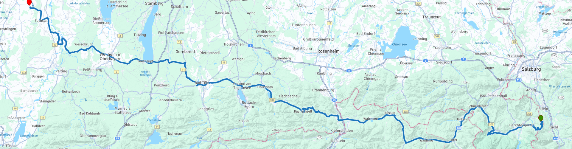
 The purpose of this trip is to travel back to the Netherlands in a pleasant way. Only 1 seriously time-consuming sight is included in the itinerary: a visit to the Kehlsteinhaus. With this extended visit you will also arrive in time at your final destination in Waal.
Along the way you drive on various pass roads, such as the Roßfeld Panoramastraße, Schwarzbachwacht, Kniepass, Paß Strub and Sudelfeldpass and you have a view of a number of beautiful lakes and rivers. All in all, this makes a wonderful route to cover kilometers, without too technically challenging roads, via the Berchtesgadener Alpen, through Tyrol and over the touristic German Alpine Road to the final destination of your holiday.
 Share this route


Animation

Verdict


Duration
8h 13m

Mode of travel
Car or motorcycle

Distance
269.65 km

Countries


 RouteXpert Review
 To get straight to the point: when you leave the hotel, turn directly onto the Roßfeld Panoramastraße (rp 3). You will be one of the first to arrive at the toll gate of the Panorama Street, after which you will ride the elegant and scenic road in all solitude and climb to an altitude of 1570m.
In the years between WWI and WWII, it was decided to build an alpine highway to open up the areas in the Berchtesgadener Alps, especially the stretch from Lindau on Lake Constance to Schönau on Königssee. At that time, it was not yet possible to construct the panoramic Roßfeldstraat. It was not until 1937, when the Alpine Motorway (Deutsche Alpenstrasse) had already taken shape, that it was decided to build the Panorama Street. At the time that WWII broke out, only a piece of about 800m had not yet been completed far enough, so that the road could not be officially opened. The Panorama Street was not fully completed until after WWII and officially opened in 1955.
Today, the Panorama Street is well attended. As a motorcyclist you will mainly enjoy the many views here. Along the way there are also plenty of opportunities to stop and take pictures of the magnificent views of the Salzach Valley, the Salzburg Alps, the city of Salzburg itself, the Dachsteiner Alps, the “Totes Gebirge” (dead mountains) and the infamous Kehlstein- mountain. In other words: your eyes will be short on the way! Don't forget to pay attention to the road every now and then. The Panorama Street also offers a modest number of wonderful (hairpin) turns.
Towards the end of the Panorama Street you have the chance to visit a special place with a charged history: the Kehlsteinhaus (rp 4). In the years just before WWII, the construction of the Kehlsteinhaus (Eagle's Nest) was completed, under the direction of Albert Speer. The NSDAP was keen to build the house on this near-impossible site, in order to show the people their unlimited power. The house is built on a mountain with sometimes impossibly steep slopes. The road to it was so complex that the inventor of the German Autobahn had to be hired to make the road possible. The top could not be reached by road, so the last 124m up was covered by a gold-plated lift.
In the years that followed, the house was widely visited and used by members of the NSDAP as well as by Eva Braun (Hitler's partner) and her family. Hitler himself only visited the house a few times.
After WWII the function of the building was changed. From status symbol only accessible to the elite, it was converted into a restaurant accessible to all. All symbols reminiscent of the Nazi dictatorship were removed. Nowadays you can look around the building and have something to eat and / or drink in the restaurant. If you want to learn more about the history, you can visit the Obersalzberg documentation center. Don't forget to walk around the top of the mountain despite the loaded place. From here you have a magnificent view of the environment around you. The ride with the bus over the narrow mountain road will also leave a lasting impression on you.
After this loaded center of gravity, the rest of your ride is mainly characterized by driving. Before you take in a bit of Austria, it is wonderful to swing through the landscape of the Berchtesgadener Alps. If you have the time and desire, you can drive to the end of the Deutsche Alpenstrasse: Schönau at the Königssee. At rp5 it is best to deviate from the route at the roundabout and follow the signage to the lake. A ride along the Hintersee (rp 8), a relatively small and unknown lake, is included along the route. Unbelievable to realize that this lake was created after a good amount of rocks rumbled down the mountain and crashed here about 4000 years ago. This gross violence has resulted in a picturesque and hidden tourist attraction.
Once back on the main road, some simple yet pleasant steps are on the menu. The Schwarzbachwacht turns into the Kniepass and then into the Paß Strub. Hardly noticeable you pass the "pass heights" each time. Visible are the crossing over the Saalach river (rp 11) (better known to the Dutch as a ski village of the same name, through which this river also flows) and your journey past Castle Oberrein (rp 12). Dating back to the 14th century, this castle offers a mighty sight from the road and has been in the hands of the state since the 20th century and is now a stately place where children with disabilities are guided on their way to a job.
On the Kniepass (rp 13) and Paß Strub (rp 14), if you drive a bit slower, you will also be able to recognize remnants of old fortresses in the distance. The location and size of the passes made them excellent places to control through traffic and to take the necessary toll. Fortunately, tolls are no longer required on these sections of the road, so you can continue your way through Austria without any worries.
It is wonderful to enjoy one last time in the Austrian Alps. At Restaurant Brandauerhof (rp 16) you can take a break, enjoy the view, have a delicious lunch and - perhaps before lunch - go down a mountain in the local toboggan run next to the restaurant.
At rp 17 you cross the Inn river and you immediately say goodbye to Austria. For part of its 518km length, this river acts as a border between Germany and Austria. It has its source in Engadine (Switzerland) and reconnects with the Danube at Passau (Germany).
After saying goodbye to Austria, you have the option to visit Burgruine Auerburg. After rp 18 turn left (instead of following the route) and after about 200m on the left there are signs signposted that mark the ruin. Not much remains of the old fortress, but it offers a great opportunity to take a break and stretch your legs and admire the llamas that graze around here.
After leaving Oberauerburg the road winds westward towards the Tatzelwurm waterfalls (rp 19). Here you can also take an optional break and stretch your legs. The Tatzelwurm consists of 2 waterfalls, which are hidden deep in the gorge. With a walk of 40 minutes you are home and away. During the walk, pay attention: the Tatzelwurm is a mythical animal that is regularly spotted here. But perhaps the waterfalls owe their name to a medieval motorcyclist: the road in this area looks like a Tatzelwurm on the map. The road continues long and winding. In short, great to steer and enjoy the journey.
On this stretch you will also pass a number of lakes. The Schliersee (rp 21), the Tegernsee (rp 22) and the Zellsee (rp 27). The first 2 lakes are natural lakes and popular attractions for swimming and sailing. The Zellsee, on the other hand, is artificial in nature. The lake was created in 1414 after Bishop Höhenkirchen dammed the Rott River to increase fishing for his beloved lakeside monastery. Today the lake is privately owned and a 161 acre protected bird sanctuary. Just before you drive down the lake, you can stop at Landgasthof Schöntag (rp 26). Even though it is only a 45-minute drive to the end point in Waal (Gasthaus zur Post), you can still enjoy the gently sloping roads.
The route receives 4 stars. It is wonderful to steer in this region. The mountain passes fly under your wheels, but usually without much spectacle. This lack of spectacle is more than compensated by the ease with which you drive through the beautiful undulating landscape. Along the way you can stretch your legs regularly and visit a number of special places, such as the views of the Roßfeld Panoramastraße, the Kehlsteinhaus and the Tatzelwurm waterfalls.


 Links
Links  Usage
Usage Want to download this route?
You can download the route for free without MyRoute-app account. To do so, open the route and click 'save as'. Want to edit this route?
No problem, start by opening the route. Follow the tutorial and create your personal MyRoute-app account. After registration, your trial starts automatically.  Disclaimer
Use of this GPS route is at your own expense and risk. The route has been carefully composed and checked by a MyRoute-app accredited RouteXpert for use on TomTom, Garmin and MyRoute-app Navigation.
Changes may nevertheless have occurred due to changed circumstances, road diversions or seasonal closures. We therefore recommend checking each route before use.
Preferably use the route track in your navigation system. More information about the use of MyRoute-app can be found on the website under 'Community' or 'Academy'.

Tyrol
About this region
Tyrol (; German: Tirol [tiˈʁoːl] (listen); Italian: Tirolo) is a state (Land) in western Austria. It comprises the Austrian part of the historical Princely County of Tyrol. It is a constituent part of the present-day Euroregion Tyrol–South Tyrol–Trentino (together with South Tyrol and Trentino in Italy). The capital of Tyrol is Innsbruck.
Read more on Wikipedia
View region
 Statistics
  35
35Amount of RX reviews (Tyrol)
 44700
44700Amount of visitors (Tyrol)
 5500
5500Amount of downloads (Tyrol)
 Route Collections in this region
 The 24 Most Beautiful Alpine Routes
The Alps, The Alps are a mountain range in Europe, stretching from the French Mediterranean coast in the southwest to the Pannonian Plain in the east. The area of the mountain range is more than 200,000 km².
In other words Passes and Mountain Roads!
Driving through the mountains is great! Especially over the mountain passes with hairpin bends and narrow winding roads. Every bend a different view where you can enjoy. There are many beautiful mountain passes in the Alps.
A selection that has also been incorporated into these routes:
The Stlevio Pass:
The Stelvio Pass, also known as Passo dello Stelvio, is mainly known for the stage in the Giro d'Italia. Due to the length and the difference in height, this pass is seen as one of the toughest tests in cycling. The Stelvio Pass reaches a maximum height of 2758 meters and is therefore one of the highest in the Alps. The pass connects the towns of Bormio and Prato Allo Stelvio. In winter the pass is closed due to heavy snowfall.
The Reschenpass:
The Reschenpass, also known as Passo di Resia, connects the Austrian state of Tyrol with the Italian province of South Tyrol. The pass reaches a maximum height of 1,504 meters and has been one of the most important north-south connections in the Alps in recent centuries. The pass was used long before Roman times. Along the way you will pass several highlights and historical relics. One of the highlights is the Reschensee. This lake was created after the construction of the dam and has completely submerged the village of Graun. The only thing that reminds of that is the clock tower in the middle of the lake.
Col du Galibier:
The French mountain pass Col du Galibier connects the towns of Saint-Michel-de-Maurienne and Briançon via the Col du Lautaret in the south and the Col du Télégraphe in the north. The mountain pass is part of the Tour de France and very much feared, due to the fact that it can only be reached via the other two mountain passes. The pass reaches a maximum height of 2646 meters. From there you can take a walk to the viewpoint at 2704 meters. You can admire the peaks of the Grand Galibier, Mont Blanc and La Meije here.
The Grossglockner High Alpine Road:
With a height of 3798 meters the Grossglockner is the highest mountain in Austria. To fully enjoy this impressive mountain, you can drive over the Grossglockner High Alpine Road and the accompanying pass. The route starts from Bruck am Grossglockner and ends in Heiligenblut. Of course you can drive in two directions. The pass reaches a maximum height of 2504 meters and is closed in winter due to heavy snowfall. Along the way you pass several stops with fun activities, information points, mountain huts and viewpoints. A visit to the Kaiser-Franz-Josefs-Höhe and Pasterzen Glacier is highly recommended.
The Col d'Izoard:
Just like the Col du Galibier, the Col d'Izoard is also part of a stage of the Tour de France. The mountain pass connects Briançon with the valley of the river Guil. The pass is partly located in the Regional Natural Park du Queyras and reaches a maximum height of 2360 meters. What is special about the Col d'Izoard is the barren and rocky landscape. Sometimes it feels like driving a car over the moon! Along the way you can stop at several points to enjoy the beautiful view.
The Bernina Pass:
The Bernina Express is one of the most famous rail trains in Switzerland and the Alps. The route is beautiful and partly included on the UNESCO World Heritage List. Parallel to the railway lies the Bernina pass, which connects the Veltlin valley with the Egandin valley. This beautiful Alpine road has a total length of 56 kilometers and reaches a maximum height of 2328 meters. Along the way you can enjoy views of the Morteratsch Glacier.
The Sella Pass:
The Sella Pass, also known as Passo di Sella, takes you over one of the most impressive mountain ranges in the Dolomites: the Sella massif. The pass connects Valle di Fassa with Val Gardena and reaches a maximum height of 2236 meters. At this height is also the border of the Italian provinces of Trentino and Bolzano. Along the way you can enjoy the view of this spectacular mountain world. Admire, for example, the three peaks of the Sasso Lungo massif, the Sella massif or the peaks of the Marmolada. You can also drive the Sella pass in combination with the Gardena pass, Pordoi pass and Campolongo pass.
The Grimsel Pass:
The Grimsel Pass connects Goms in Wallis with the Halis Valley in the Bernese Oberland. The pass reaches a maximum elevation of 2165 meters and is closed in winter due to snowfall. Over the centuries, the mountain pass has played an important role in trade between Switzerland and Italy. Now it is mainly the reservoirs that have an important function. These are used to generate electricity. The landscape you drive through is rugged, rocky and impressive. On top of the pass is a hotel and a restaurant with a special marmot park. The Dodensee (Totensee) is also located here. This lake owes its name to the many soldiers who died in the time of Napoleon.
The Gotthard Pass:
The Gotthard Pass, also known as Passo del San Gottardo and Saint Gotthard, connects the Swiss towns of Airolo and Andermatt. The mountain pass and associated tunnel are especially known among holidaymakers driving from Switzerland to Italy. But where the majority opt for the tunnel, it is precisely the pass that really completes the holiday. The Gotthard Pass has a length of about 26 kilometers and reaches a maximum height of 2106 meters. The route is beautiful and takes you along old villages and beautiful views.
The Silvretta High Alpine Road and Silvretta Pass:
The Paznaun Valley in Tyrol and the Montafon in Vorarlberg are connected by the Silvretta High Alpine Road. The route has a length of 22.3 kilometers and leads from Galtür to Partenen in 34 hairpin bends, via the 2032 meter high Bielerhöhe. The Silvrettasee is also located at this point, where you can enjoy a lovely walk. The pass is closed in winter due to snowfall.
The Simplon Pass:
Just like the Gotthard Pass, many holidaymakers also travel over the Simplon Pass every year. This mountain pass connects the Rhone Valley in the canton of Valais with the Valle d'Ossola in Piemonte. The pass is open all year round and reaches a maximum height of 2005 meters. Along the way you pass a number of buildings, including the well-known Simplon Hospiz from 1825. The hospiz is managed by the monks of St. Bernard. From the highest point on the pass, all kinds of hiking routes are possible and you will also come across a hotel where you can spend the night.
The Gerlos Pass:
The Gerlos Pass connects the Salzach Valley in the Salzburgerland with the Zillertal Valley in Tyrol. The pass is part of the Gerlos Alpenstraße and runs right through the Hohe Tauern National Park. Along the way you can enjoy beautiful views of the surroundings. The pass has a length of 12 kilometers and reaches a maximum height of 1531 meters. A ride over the Gerlos Pass can be ideally combined with a visit to the Krimmler Wasserfälle.
The Great St. Bernard Pass:
The Great St. Bernard Pass, better known as Col du Grand Saint Bernard, connects the Italian province of Valle d'Aosta with the Swiss canton of Valais. The pass is one of the highest in Switzerland and reaches a maximum height of 2469 meters. Like a number of other mountain passes in this list, the Great St. Bernard Pass has also been used as a connecting road for centuries. The pass is named after the St. Bernard dogs that used to help stranded travelers along with the monks. The pass is closed in winter.
The Timmelsjoch High Alpine Road:
The Timmelsjoch High Alpine Road connects the towns of Sölden in the Ötztal and Meran in South Tyrol. Tolls must be paid on the Hochgurgl - Moos route. Via a mountain road with about 60 hairpin bends you drive through a beautiful mountain world. With the Timmelsjoch Experience you can learn more about the history, the road and the environment via various stations. You can also visit the Top Mountain Crosspoint museum.
Col de l'Iseran:
With a maximum pass height of 2770 meters, the Col l'Iséran is one of the highest mountain passes in the Alps. The pass connects Bourg-Saint-Maurice with Bonneval-sur-Arc. Via a road full of hairpin bends you pass, among other things, Val-d'Isère and a side valley of the Maurienne that lies entirely in the National Park de la Vanoise. You can spot animals such as marmots and chamois and there is also a restaurant with a chapel on top of the pass.
The Gavia Pass:
The Gavia Pass (Italian Passo di Gavia) is a mountain pass in the Italian Alps, in the Lombardy region.
It is one of the highest pass roads in Europe. The road leads through the unspoilt Stelvio National Park. The road was built in the First World War to supply Italian soldiers who fought in the Italian-Austrian border area. The pass height is one of the most beautiful in the Alps. Here is the large Lago Bianco with, to the north, the mountain San Matteo (3684 meters). Lago Nero is slightly lower on the south side of the pass. Here the mountain group of the Adamello determines the view. There are many well-marked walks in the area. During the winter the pass is closed due to the heavy snowfall. The pass is often closed until May and June due to the large amount of snow.
Promoter has made a selection of the 24 Most Beautiful Alpine routes that they have set out in recent years.
The routes go through:
France
Austria
Switzerland
Italy
The most beautiful roads, the most beautiful views, the most beautiful viewpoints. The highest mountains, the fastest descents, hairpin bend after hairpin bend, you name it you can't get enough of it.
If you go on holiday in this region, take advantage of it, ALL routes in this collection have been checked and made equal for TomTom, Garmin and MyRoute-app Navigation by a MyRoute-app RouteXpert.
Have fun with this collection and while driving one of these routes. Enjoy all the beauty that the Alps and the Dolomites have to offer. Click on “View route” to read the review of the chosen route.
I would like to hear your findings about the route(s).
View Route Collection
The 12 most beautiful car and motorcycle routes in Carinthia
“Motorradland Kärnten” where you feel so wonderfully welcome as a motorcyclist!
Own website for motorcyclists, own curated routes, hotels, campsites and guest houses with attention for motorcyclists, a wonderful area where motorcyclists are very popular.
Kärnten or Carinthia, at the crossroads of the Germanic, Slavic and Roman worlds. Three cultures within a few kilometres, southern flair, culinary delights, cross-border tours. Breakfast in Italy, lunch in Slovenia, dinner in Austria - all in one day. Experience the diversity in the borderless Alps-Adriatic region, the area for motorcyclists.
Extensive day trips on winding mountain paths, romantic panoramic routes and beautiful lakes, here the 12 TOP routes Kärnten / Carinthia. Enjoy!
View Route Collection