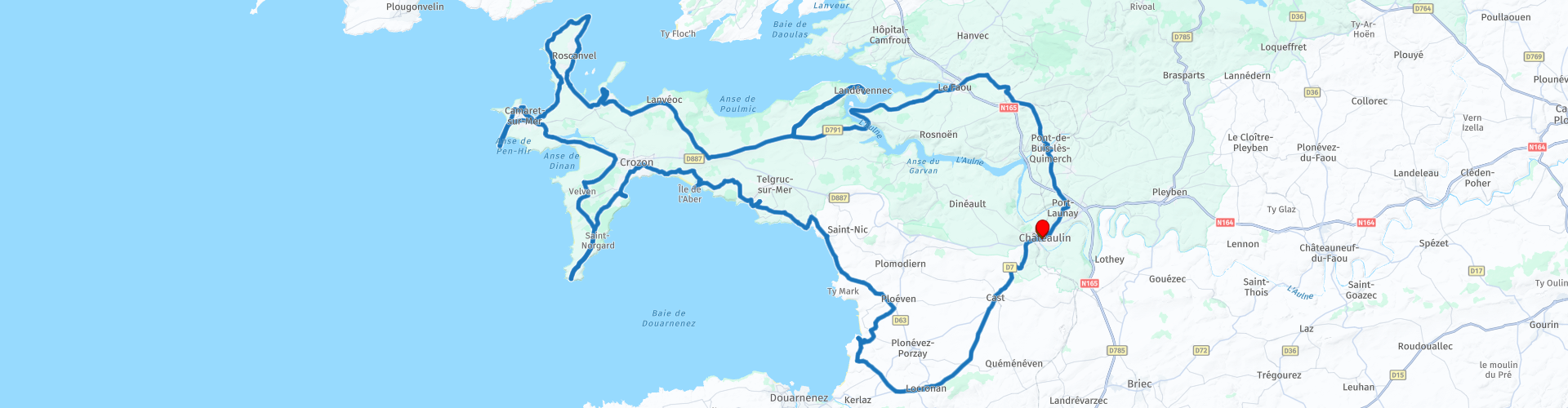
Roundtrip from Chateaulin

This route was brought to you by:
RouteXpert Jan Koelstra (jan cabrio)
Last edit: 02-02-2025
 Route Summary
 Endless beaches and rugged rocky peaks, steep cliffs and idyllic bays, overgrown forts and prehistoric megaliths, picturesque harbours and impressive monuments. Brittany in a nutshell.
Crozon is all coast: at the western end of this headland that extends far into the sea, three more sub-peninsulas 'hang'. Jagged cliffs, wonderful beaches, awe-inspiring rocky peaks, hidden coves. This tour therefore gets a five-star rating.
Details:
Map corrections are needed in Camaret-sur-Mer due to seasonal traffic there.
 Share this route


Animation

Verdict


Duration
10h 4m

Mode of travel
Car or motorcycle

Distance
190.73 km

Countries

 RouteXpert Review
 When you look at Crozon on the map, you immediately notice that this must be a special part of France. Wedged between two other peninsulas, with Brest to the north and Cap Sizun to the south. It lies in the sea like an anchor, with pointed protrusions on all sides. On the east side it is bordered by the Menez Hom, a peak of 330 meters that seems to guard the entrance to the peninsula. The pointed protrusions are the 'pointes', the capes, almost all of which are worth a visit. During the road trip that you will make across the peninsula, you will get to know this phenomenon.
The Crozon peninsula is like a huge cross in the Mer d'Iroise. It has everything Brittany has to offer, but in a nutshell. It is a landscape in which spectacular cliffs, heathlands, the blue-green ocean and wonderful beaches alternate.
Your tour starts and ends in Châteaulin.
Halfway between Brest and Quimper, Châteaulin, or Kastellin in Breton, is the story of a fortified hill that gave its name to a town built on either side of the banks of the peaceful, fish-rich River Aulne. Two interesting churches stand for a rich religious heritage: Notre-Dame and Saint-Idunet, one on each side. Notre Dame is in the old part on the 'quiet' side of the river, with a triumphal arch, an ossuary and a beautiful interior. On the way back, there is a breather in the centre at the other church. A fuel stop is planned just outside the village and then back towards the coast.
The first town on your route is Locronan, which belongs to the very private clubs of “petites cités de caractères” (characteristic towns) and “most beautiful villages in France”. On peak days and during the busy season, the town is closed to motor vehicles. You will quickly understand why when you walk through the town and see the magnificent houses that radiate around the central square with its old wells. In summer, the soft light of the morning gives the old stones of the town a golden glow. Elegant houses with carved windows surround the square. The Eglise Saint-Ronan and the chapel of the Pénity stand side by side and share a common façade, without mingling with the gargoyles. In the nave, the pulpit and stained glass windows tell of various religious events. In order to protect the authenticity of the historic centre, cars are kept outside the centre and the shops are indicated with traditional signs. Among them are the bakeries that make the formidable Kouign-Amman (Breton butter cake).
The first destination of your tour of the Presqu'île de Crozon is the Cap de la Chèvre, or Beg Penn ar Roz as it is called in Breton. As you drive in that direction you will pass Moulin de Luzeoc, a beautifully restored historic water mill and a little further on, the Île de l'Aber with the fort of the same name. Built as a defence against hostile invasions, this fort now offers a great view over the coast. A little further on are the remains of a historic lime kiln Four à Chaux Rozan where limestone was processed. The ruins are impressive and tell of the working history of the region.
In Morgat, a coffee stop at the harbour is a pleasant change.
The cliffs at the Cap de la Chèvre are covered with endless fields of heather and gorse, which provides a colourful palette, especially towards the end of the summer. You can almost walk to the tip. After you have parked, it is a few minutes' walk to the semaphore that has been here since the early 1970s. The remains of a few bunkers can also still be discovered. The Cap de la Chèvre was a strategic location, at the northern end of the bay of Douarnenez. And it still is, as evidenced by the presence of the semaphore of the French navy, which forms part of the French coastal defences. At the bottom of the semaphore is also a memorial to soldiers who died while performing their duties at sea. There are also a number of hiking trails across the cape, some of which take you right along the cliffs. Because there are more of these types of capes to see, you will limit yourself to a short photo moment.
If you like characteristic villages in special places, you can stop in the hamlet of Rostudel, where you will find the granite houses typical of the region that have braved the elements here for centuries. Then it is on to the next cape. The Pointe de Dinan is one of the lesser known and less visited 'pointes' of the peninsula, but one of the most impressive. You can walk here for about half an hour to three quarters of an hour, during which you will see the three separate capes of this pointe in all their glory. Particularly striking is the so-called château de Dinan, which (and hence the name) looks like a kind of natural castle.
If you continue driving across the peninsula you will eventually reach the westernmost part with the town of Camaret-sur-Mer.
Here is the planned lunch stop. A nice place to have lunch is of course at the harbour with a view of the harbour.
Afterwards, you can still go to the pier where the chapel of Notre Dame de Rocamadour is located, famous for the ship models that were given a place as an ex-voto. Next to it is the Tour de Vauban, often called the golden tower because of its ochre colour. The fortress tower, which used to guard the Sillon de Camaret and the entrance to the Brest Strait, is on the UNESCO World Heritage List.
This protrusion of the island has three separate pointes. Of these, the Pointe de Pen-Hir is the most famous and impressive. Incidentally, that name is a bit of a double entendre, because pen is also pointe in Breton. You park at the very end and walk towards the cliffs from where you have a wide view over the sea. With a bit of clear weather, you can clearly see the Pointe du Raz, the Molène archipelago and Ouessant in the distance. Another special feature of this cape is the presence of various small rocky points (the “pea heaps”) in the sea, around which the water wildly laps.
But first you pass the Pointe du Pointe du Toulinguet, the westernmost point of the Crozon peninsula, which you may want to visit.
Leaving Camaret and heading towards the Pointe de Pen-Hir, you will pass the vast menhir field Alignment of Lagatjar. The three rows of menhirs are no longer complete but are still very impressive. The longest row is 203 metres long. In total, there are about a hundred menhirs left. They are made of quartz rock. Archaeological research has determined that they were made between 3000 and 2500 BC.
After the cape you drive back past the Batterie de Kerbonn. There were already fortifications at this location before the Second World War, but the Germans went even further. In one of the remaining bunkers there is now a small museum about the war on the Atlantic Ocean. It jumps around a bit, but is interesting to visit. The rest of the bunkers are freely accessible. From the most northern one you have a magnificent view of one of the most beautiful beaches in Brittany, the Plage de Pen-Hat.
On to the northern side of the Crozon peninsula, towards the Pointe des Espagnols, north of Camaret. This name comes from the Spanish occupation during the religious wars at the end of the sixteenth century. This point on the Roscanvel peninsula guards the roadstead of Brest, the bay that begins here and has an area of one hundred and eighty square kilometres. If you control this place, you control the access by sea to a significant part of Finistère. In recent centuries, the Pointe des Espagnols has remained strategically important.
And still, because even today there is a military presence in this part of Brittany. The next fold of the Crozon peninsula is almost entirely taken up by a military base. Just before that is a boat cemetery of Rostellec which is well worth a visit. Here photographers can get very close to the rotting old boats of the sailors. Some ships have deteriorated so much over time that only the frames still remind us of the shape of the boat. This place is even more interesting than the one here in Camaret-sur-mer. In Brittany and elsewhere there are several beaches and estuaries where old boats and shipwrecks rot. This has little to do with cost-effective disposal. For the former boat owners it has to do with an old tradition that every boat has a soul and the prevailing belief is that scrapping a boat that has served a long time brings bad luck. The boats are moored for the last time on the beach or on the shore and left to their fate.
Passing the stump of Moulin du Chat, surrounded by greenery and ideal for a photo opportunity, it passes Lanvéoc with an important air base for the French Navy, visible from the road.
On the other side of the shore, at the tip of the Bay of Brest, Landévennec is situated on a rocky spur. Between the trees, this village stretches along the former abbey of the 17th century church, from where you have a magnificent view of the winding river, the island of Térénez and the romantic ship museum.
Saint Guénolé chose this heavenly place to found the oldest Breton sanctuary around 485. Beautiful remains of the buildings from the 11th and 12th centuries can still be seen. High walls, pillar bases and traces of the nave have survived time and the Revolution. The accompanying museum of the former abbey, located on the edge of Landévennec, brings the history of this memorial site to life and also focuses on the development of present-day Brittany in its exhibitions and animations.
The port town of Le Faou enjoyed a golden age in the 16th and 17th centuries, when beech and oak timber from the nearby forest of Le Cranou were shipped from the port to the shipyards of Brest. As you walk down the main street, you will see a whole row of half-timbered houses with their facades turned towards the street (16th century). They show how the construction of houses helped to make the trading activities visible to travellers. Over the centuries, the facades were covered with elaborately worked slate, giving each house its own character. Le Faou is one of the few places in Brittany where this type of house has been preserved. At the end of this street full of trading activities stands the beautiful and proud church of Saint-Sauveur (16th century).
You have now left the peninsula and are heading for home.
A little further on in Rumengol is a beautiful 16th century church with a paroissial enclos. The basilica is famous for its typical Breton processions, pardons, in honour of Notre-Dame de Tout Remède, which attract visitors from all over Brittany. It is a colourful event where thousands of pilgrims gather for a procession, prayers and festive activities. They wear traditional Breton costumes and bring offerings to the Virgin Mary. Traditional music, played on the bombarde (a type of oboe) and biniou (Breton bagpipe), accompanies the procession.
Via the Belvédère de Roscoat, a viewpoint with a panoramic view of the Aulne valley and the surrounding forests. and Port-Launay, it goes to Châteaulin, where it is time for a nice spot to contemplate it all with a drink and a bite to eat.


 Links
Links  Usage
Usage Want to download this route?
You can download the route for free without MyRoute-app account. To do so, open the route and click 'save as'. Want to edit this route?
No problem, start by opening the route. Follow the tutorial and create your personal MyRoute-app account. After registration, your trial starts automatically.  Disclaimer
Use of this GPS route is at your own expense and risk. The route has been carefully composed and checked by a MyRoute-app accredited RouteXpert for use on TomTom, Garmin and MyRoute-app Navigation.
Changes may nevertheless have occurred due to changed circumstances, road diversions or seasonal closures. We therefore recommend checking each route before use.
Preferably use the route track in your navigation system. More information about the use of MyRoute-app can be found on the website under 'Community' or 'Academy'.

Brittany
About this region
Brittany (Breton: Breizh [brɛjs]; French: Bretagne [bʁətaɲ]) is the farthest west of the regions of Metropolitan France. It is covers about four-fifths of the territory of the historic province of Brittany. Its capital is Rennes.
Brittany is a peninsular region bordered by the English Channel to the north and the Bay of Biscay to the south, and its neighboring regions are Normandy to the northeast and Pays de la Loire to the southeast. Bro Gozh ma Zadoù is the anthem of Brittany. It is sung to the same tune as that of the national anthem of Wales, Hen Wlad Fy Nhadau, and has similar words. As a region of France, Brittany has a Regional Council, which was most recently elected in 2015.
Read more on Wikipedia
Brittany is a peninsular region bordered by the English Channel to the north and the Bay of Biscay to the south, and its neighboring regions are Normandy to the northeast and Pays de la Loire to the southeast. Bro Gozh ma Zadoù is the anthem of Brittany. It is sung to the same tune as that of the national anthem of Wales, Hen Wlad Fy Nhadau, and has similar words. As a region of France, Brittany has a Regional Council, which was most recently elected in 2015.
View region
 Statistics
  12
12Amount of RX reviews (Brittany)
 16160
16160Amount of visitors (Brittany)
 493
493Amount of downloads (Brittany)
 Route Collections in this region
 25 Magnificent trails in France
This MRA route collection contains 25 beautiful motorcycle routes in different parts of France, such as the Ardennes, the Alsace, Vercors, the Drôme, the Ardèche, Cote d'Azure, Gorges du Verdon, the Ariège, the Dordogne and Brittany.
The routes have been carefully created by Bert Loorbach, who is an enthusiastic motorcyclist himself. He lived in France for a year and a half, during which time he devoted himself to mapping the unknown and beautiful back roads of France especially for motorcyclists.
The routes are bundled in the Motortourgids France part 1 of Kosmos publishing house and now also available in MyRouteApp.
I have taken over the routes in MRA and sometimes adjusted them slightly to make them even more interesting for the motorcyclist.
View Route Collection
3 day mini break through Brittany and Normandy
The overnight ferry crossing from Plymouth to Roscoff is a relaxing way to begin your 3 days of sightseeing in North West France. Touring the coasts and countryside of Brittany and Normandy, you'll discover beautiful sandy beaches, tiny fishing ports, bustling market towns and iconic and historical sites. Don't forget to sample Brittany's renowned seafood and delicious sweet and savoury pancakes, or Normandy cider and of course their 'hard to say no to' apple brandy, Calvados .
Day 1 takes you along the beautiful and rugged coast to Mont St Michel, a World Heritage site, visible for miles around. This is a wonderful place at any time of year, although be prepared for it to be very busy in summer. Your first hotel is just 30 minutes further along the coast at Hôtel Ibis Avranches Baie du Mont Saint-Michel. Other hotels are nearby and links for this hotel and your second night at Port en Bessin are in the individual route reviews.
Day 2 takes you first to Bayeux, world famous for its astonishing tapestry depicting the Norman Conquest of England in 1066, remarkable as a work of art and important as a source for 11th-century history. Bayeux also has a picturesque old quarter, WW2 museum and cathedral worth visiting (park motorcycles next to cathedral).
Then you can take in the sobering atmosphere at Pegasus Bridge, liberated by the British 6th Airborne Division glider unit, a full size replica of a Horsa glider shown in the picture above is on display, and the tale of the men it transported gives you a remarkable insight into the scale, ferocity and poignancy of Operation Overlord. Arromanches' Mulberry Harbour (Port Winston) and the gun emplacements dotted along the coast that you'll visit are reminders of the combats that took place here over 70 years ago. A great night is guaranteed at your second hotel in the fishing port of Port en Bessin where you can sample local cider (cidre) some of the freshest seafood available, fine wine, and finish off with some local calvados.
Day 3 tells the American story of D-Day with visits to Omaha and Utah beaches, various museums and the first town in France to be liberated during operation Overlord - Sainte-Mère-Eglise where an effigy of private John Steele dangles by his parachute from the church steeple.
Your return to the UK is via Cherbourg, to either Poole or Plymouth depending on the time of year, most sailings are around 17:00 hrs. Details from Brittany Ferries can be found in the link in the first review.
This is a great mini tour that'll give you a good glimpse of what this part of northern France has to offer and will leave you wanting to return.
View Route Collection