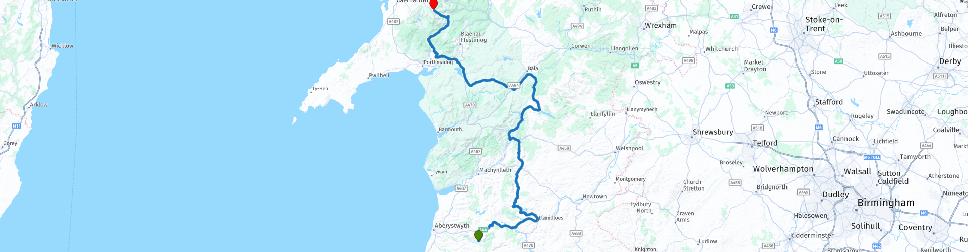
Devils Bridge to Nant Peris in Snowdonia National Park

This route was brought to you by:
RouteXpert Nick Carthew - (MRA Master)
Last edit: 07-07-2021
 Route Summary
  Share this route


Animation

Verdict


Duration
6h 36m

Mode of travel
Car or motorcycle

Distance
183.73 km

Countries

 RouteXpert Review
 The majority of this route uses 'roads less travelled' so you won't encounter too many other tourists. As you enter the Snowdonia National Park, you must stop at RP 14 for a view or photo of Pont Minllyn, a bridge spanning the River Dovey (Dyfi). The miniature proportions and mossy green appearance of this two-arched bridge give it a fairytale feel, but it was actually built for practical workaday reasons in the early 17th century to allow packhorses to cross the river.
Follow the River Dovey for a few miles and you will come to a sharp hairpin bend takes you up a steeply sided valley and onto a vast open moorland offering breathtaking views. The road is single track but the only thing that you'll likely encounter are sheep. As you descend from the high ground you arrive at Lake Vyrnwy, set in such a beautiful location, the mountains embrace the lake that contains some twelve billion gallons of water resulting in scenery reminiscent of the Alps. The lake which is 5 miles long and half a mile wide looks incredibly natural and you can hardly believe that it was created by man in the late 19th century to provide a storage reservoir of safe water for the rapidly growing city of Liverpool.
The road leaving the reservoir is single track again and equally as beautiful, this time though it's through a heather covered valley that will take you to touristy, honey pot, market town of Bala on the shore of Bala Lake, or Llyn Tegid. You can choose to have some lunch here or continue the route following the narrow-gauge railway which runs along the east shore of the lake to Llanuwchllyn where I have chosen the Eagles Inn as a lunch stop. The Eagles Inn (Tafarn Yr Eryod) is a wonderful stone built building, even older than the village church that serves delicious home made food!
After lunch, a single track road heads up the Afon Lliw valley into what must be one of the least visited parts of Snowdonia National Park. The road has several gates as it rises up to open moorland with grazing sheep. Please leave each gate as you found it (open or closed). Again, more breathtaking views, to the north you see the peaks of Arenig Fawr (854m) and Moel Llyfnant (751m) and as you reach the summit the mountain range of the Rhinogs dominate the view ahead of you to the west.
After joining the A470, you will pass Lake Trawsfynydd, created 100 years ago to supply water for a hydro-electric power station. Then in 1965 the reservoir became the source for cooling water for a nuclear power station, in 1991 the nuclear power station was shut down and is now in the process of decommissioning. Work will be completed in 2083!!
RP 32 takes you past the beautiful settings of Lake Mair, created in 1889 by William Edward Oakeley, owner of a slate quarry as a 21st birthday present for his daughter Mair and as a water supply.
Next comes the Nant Gwynant Pass and it's two natural glacial lakes joined and fed by the River Glaslyn. The second of the two Lakes, Gwynant was used as a filming location in the 2003 film 'Lara Croft Tomb Raider: The Cradle of Life'.
Views of Mount Snowdon are visible through this valley pass.
Take a left turn onto the A4086 that'll take you through the Pen-y-Pass. At the top of the pass is a car park and a good place to stop for photos and maybe a coffee. This spectacular pass is one of my favourites and has a jurassic feel about it with scattered boulders covering the mountain pass floor. You feel part of it when riding through it on a motorcycle.
The end of the route is at Nant Peris as you descend towards Llanberis. Nant Peris has a few campsites for pitching a tent or the town of Llanberis just down the road has many hotels and B&Bs; for your overnight stay. I have include links for a couple of campsites below this review. Enjoy.


 Links
Links  Usage
Usage Want to download this route?
You can download the route for free without MyRoute-app account. To do so, open the route and click 'save as'. Want to edit this route?
No problem, start by opening the route. Follow the tutorial and create your personal MyRoute-app account. After registration, your trial starts automatically.  Disclaimer
Use of this GPS route is at your own expense and risk. The route has been carefully composed and checked by a MyRoute-app accredited RouteXpert for use on TomTom, Garmin and MyRoute-app Navigation.
Changes may nevertheless have occurred due to changed circumstances, road diversions or seasonal closures. We therefore recommend checking each route before use.
Preferably use the route track in your navigation system. More information about the use of MyRoute-app can be found on the website under 'Community' or 'Academy'.