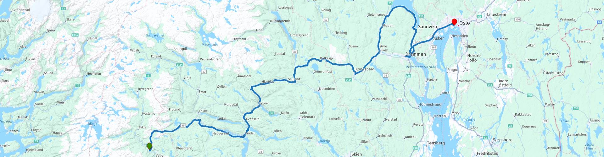
Flateland via Telemark Vradal Kongsberg Vikersund to Oslo

This route was brought to you by:
RouteXpert Evert Kuiken
Last edit: 22-12-2020
 Route Summary
  Share this route


Animation

Verdict


Duration
6h 28m

Mode of travel
Car or motorcycle

Distance
367.21 km

Countries

 RouteXpert Review
 We started this part at camping Flateland. A very nice, quiet camping alongside a river (what else...) with many cabins and even a small shop. The river runs in the Setesdal. A very nice vally, but we already saw part of it, so we go back up into the hills.
First thing we come across is a waterfall "Gloppefossen" (RP 2). You can stop here for a short walk if you haven't seen enough already. Nice but not spectacular. A few kilometers further is another waterfall "Edlandsfossen" (RP3). Also nice and can be seen from the road. After that you come to an art museum in the open air ("Grimdalstunet", RP4). A nice stroll.
Then we take a small detour from the 45 to the right. A very nice road that takes you to Skafså with a small church ("kirke" RP6). Here you can choose between the gravelroad to the right or ahead on tarmac via a somewhat bigger road (38). Either way you end up in Åmdal with a copper mining museum (RP8). Really worthwhile a visit, which takes an hour.
From there you go to the Vrå lake. At Vråliosen (RP10) you can make a choice. Keep following the bigger road 38, or take the smaller FV455/3392. I suggest the latter. You have a better look at the lake and I like small curvy roads.
At the end you get to a small peninsula with a golf resort. There is a small restaurant (RP13) with a gorgeous view of the lake Vrå. Unfortunately it was not open when we visited it. They were refurbishing it. It looked very new already...
From the golf resort you go to the town of Vrådal. Be aware that you will pass over two very small bridges (RP14), not suitable for cars. There you can visit the Vrådal Slusemuseum. Small but nice. In the town of Vrådal (RP15) you can do some shoppings and fuel your motorcycle.
After that you get to Kviteseid Bygdetun museum (RP 16). A few old wooden houses and a nice church. Only open during the season from Thursday till Sunday.
At Flatdal we skip the new tunnel by driving around it (RP17). If you want to make some exhaust noise, you can take the tunnel. I prefer to see nature. Then it is quite a drive to Kongsberg (RP19). Here you can have lunch, a drink, go shopping, see the nice town. There is a nice church and again a mining museum.
After Kongsberg we head up to Finnemarka. A peninsula where you can walk very nice (not spectacular) and stay overnight at Natvedt camping (RP22). They only have a few hytter and they are a bit old. But you can cook and sleep. And there is access to the lake where you can swim (brrr, it was too cold for us...). Shops nearby are in Vikersund (RP21). Finnemarka is OK, but not very special. If you prefer a stay in Oslo, at RP20 you can take the road from Kongsberg to Drammen and drive on to Oslo, skipping Finnemarka (RP21 and RP 22).
In Drammen you can decide to visit the Spiralen. This is a spiral tunnel inside a mountain. It takes you in a few rounds up to the mountain to a spectacular view. But evidently the tunnel itself is also spectacular.
From here you can drive (the next day) to Oslo to the ColorLine ferry to Kiel (RP23). And if you have time left of course you can visit Oslo and all of it's nice sights. I will not elaborate on this: enough travel guides can help you out.
My rating for this route is 4****. The roads are excellent. The surroundings are beautiful, And there are some nice sights. Nothing spectacular but very worthwhile a visit. I especially liked the Vrå lake area.


 Links
Links  Usage
Usage Want to download this route?
You can download the route for free without MyRoute-app account. To do so, open the route and click 'save as'. Want to edit this route?
No problem, start by opening the route. Follow the tutorial and create your personal MyRoute-app account. After registration, your trial starts automatically.  Disclaimer
Use of this GPS route is at your own expense and risk. The route has been carefully composed and checked by a MyRoute-app accredited RouteXpert for use on TomTom, Garmin and MyRoute-app Navigation.
Changes may nevertheless have occurred due to changed circumstances, road diversions or seasonal closures. We therefore recommend checking each route before use.
Preferably use the route track in your navigation system. More information about the use of MyRoute-app can be found on the website under 'Community' or 'Academy'.