R09 Roundtour Bodo to Lofoten part 1

This route was brought to you by:
RouteXpert Arno van Lochem - Senior RX
Last edit: 20-05-2021
 Route Summary
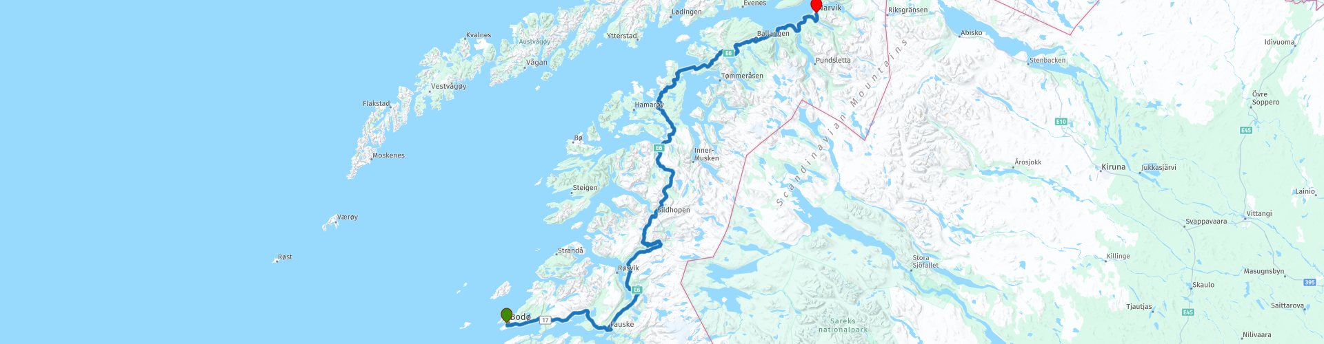
 You can also see this ninth part as part one of a three-part round trip from Bodø to and across the Lofoten.
The routes are easy for everyone to drive and are on well-paved roads. There may be a single hairpin bend to be taken, but these are fine.
If there is a piece of gravel in the route, a warning will be given and a detour will be indicated.
In this part you drive north again along beautiful fjords. The ferry takes you from Bognes to Skarberget. Then follow the E6 further north until you reach Narvik.
The final destination is a hotel, but the camper has also been thought of, there are a number of campsites indicated where you can rent a hiker's cabin or camp.
The participants of the Arctic Challenge started in Bodø and received a first coordinate which is in Bjerkvik, north of Narvik. The next coordinate turned out to be at the ferry in Moskenes, where the crossing to Bodø could be started. The same evening they reported back to the hotel.
Beautiful scenery and views, excellent roads and nice sights, hence the 4-star rating.
 Share this route


Animation

Verdict


Duration
9h 4m

Mode of travel
Car or motorcycle

Distance
314.45 km

Countries

 RouteXpert Review
 Of all western European countries, the Scandinavian countries probably have the most more or less untouched nature. In addition, they are countries that are easily accessible from the Netherlands. Norway is characterized by, among other things, the fjords and the Trollstigen, known to many motorcyclists. And where Sweden is known as wide and relaxing, everyone knows Finland as the land of 1000 lakes. All in all, legitimate reasons to traverse this beautiful nature in the north of Europe by means of a number of routes.
The route starts in Bodø and initially heads east. You drive on the road with number 80 to Fauske where it is time for coffee. In Fauske you pick up the E6 again and it goes north immediately after coffee.
You soon reach the Sørfolda, a fjord with a length of 40 kilometers. This fjord is a southeastern branch of the main Foldafjord. The deepest part of this fjord is 573 meters. So it is better to stay on the road.
When rounding this fjord you drive over the Trengsel bru. This is a concrete arch bridge with a high deck. The bridge has a total length of 179 meters and a main span of approximately 120 meters. The bridge spans the Nordfjord, a side arm of the Tørrfjord. The exact height of the bridge is unknown, but it is approximately 10 - 15 meters. The short Trengseltunnel is located directly east of the bridge.
A few kilometers further you can put the engine aside and enjoy the view over the Sørfolda for a moment. That's definitely worth a photo. Once back on the road, you will head towards the second coffee break, but not before you have the opportunity to stop at the Leirfjord, a 20-kilometer-long fjord.
When you've finished your coffee at Kobbelv Vertshus, you really have to walk down the back of the restaurant and go up the wooden bridge. You will then see a nice waterfall, the Polarbaan. Not very big, but the water still falls a few meters. Good enough for a lot of noise and a photo.
A number of viewpoints are indicated in the next part, but there is so much to see that you might want to stop a bit more often than indicated in the route. Do especially! You can't believe your eyes. Unfortunately you also pass a number of tunnels, in this area they are difficult to get around, there are not that many roads.
Twenty kilometers after the refueling stop you will arrive at the ferry, which will take you to Skarberget. But before you get on the boat you can first fill your stomach at Bognes Veikro. If you have good weather you can have lunch with a view of the ferries.
After lunch you will drive on the boat, but take the correct position (on the right), otherwise you will go to Lødingen, located on the Lofoten. Just a little while longer, that's where part 2 of the tour comes along. If you want to do the tour of the Lofoten in two days, you have the option to cut a piece here.
For information on sailing times and prices see the useful links below.
Once off the boat, continue on the E6. After only a few kilometers you have two parking spaces behind each other where both have a reason to stop: The view is great and you really don't want to miss it.
Five kilometers further you come to the Efjorden. You cross this by means of three bridges. The first, the Sørstraumen bru has a length of 162 meters and a sailing height of only a few meters.
The second bridge that you cross is the Mellastraumen bru with a length of 143 meters. The main span is 200 meters and the maximum distance to the water is 15 meters. This is the smallest of the three.
The last bridge is the Kjerringstraumen bru, a suspension bridge. With a length of 551 meters, a main span of 200 meters and a maximum distance to the water of 18 meters, this is the largest of the three. The bridge has 15 spans.
Further along the route you can visit the Ballangen Museum in Ballangen. This museum is part of Museum Nord, a museum consortium. The museum is located just outside Ballangen and is housed in the old Bjørkåsen mines administration building that was built in 1919. The museum focuses on exhibitions related to the mining activities that have taken place in Ballangen since the 17th century.
The museum previously had a 600-meter-deep visitor mine, which is unfortunately no longer open to the public. Using images, texts and objects, the museum presents the story of the Bjørkåsen mines from its inception in 1911 to its closure in 1964. Test operations started in 1910 at the mine and the mining company was licensed in 1913. There are also exhibits on daily life in the area, fishing, agriculture, local culture and education.
More than twenty kilometers further on the route you will find the Skjombrua. The Skjombrug spans the Skjomenfjord, approximately 20 kilometers south of Narvik. The suspension bridge has a total length of 711 meters and a main span of 525 meters. The bridge deck hangs 35 meters above the fjord. The E6 runs over the bridge with 1x2 lanes. From the bridge you have a good view of the Skjomenfjord.
The Skjombrug is one of Norway's older suspension bridges and was built in the early 1970s to replace a ferry service on the E6. The bridge opened to traffic on November 10, 1972. The bridge was built at one of the narrowest points in Norway, the distance between the border with Sweden and the Skjomenfjord is only 8 kilometers. The bridge itself is 28 kilometers from the Swedish border.
Once you have crossed the Skjombrua you will soon enter Narvik, the place where the hotel is located where the route ends. Just before the (last) bridge you can still fill the tank if necessary, so that you are ready for tomorrow's route again.
Scandic Narvik is a hotel with a restaurant and a bar, so that here again the route can be evaluated while enjoying a beer. That is of course also possible in the city, there are a few pubs indicated.
For campers there are two campsites in the vicinity of the end point indicated: Narvik Camping and Øyjord Camping.
Have fun driving this route!


 Links
Links  Usage
Usage Want to download this route?
You can download the route for free without MyRoute-app account. To do so, open the route and click 'save as'. Want to edit this route?
No problem, start by opening the route. Follow the tutorial and create your personal MyRoute-app account. After registration, your trial starts automatically.  Disclaimer
Use of this GPS route is at your own expense and risk. The route has been carefully composed and checked by a MyRoute-app accredited RouteXpert for use on TomTom, Garmin and MyRoute-app Navigation.
Changes may nevertheless have occurred due to changed circumstances, road diversions or seasonal closures. We therefore recommend checking each route before use.
Preferably use the route track in your navigation system. More information about the use of MyRoute-app can be found on the website under 'Community' or 'Academy'.

Nordland
About this region
Nordland (Norwegian pronunciation: [ˈnûːrlɑn] (listen); Lule Sami: Nordlánnda, Southern Sami: Nordlaante, Northern Sami: Nordlánda, English: Northland) is a county in Norway in the Northern Norway region, bordering Troms og Finnmark in the north, Trøndelag in the south, Norrbotten County in Sweden to the east, Västerbotten County to the southeast, and the Atlantic Ocean (Norwegian Sea) to the west. The county was formerly known as Nordlandene amt. The county administration is in the town of Bodø. The remote Arctic island of Jan Mayen has been administered from Nordland since 1995. In the southern part of the county is Vega, listed on the UNESCO World Heritage Site list.
Read more on Wikipedia
View region
 Statistics
  16
16Amount of RX reviews (Nordland)
 14921
14921Amount of visitors (Nordland)
 783
783Amount of downloads (Nordland)
 Route Collections in this region
 In 12 Days from Oslo to the North Cape
This is a route collection of a motorcycle tour from Oslo to the North Cape, based on a journey by Thomas Falck Østli. A total of twelve routes have been described, but the tour can be extended to more days, more information about this in the reviews.
The routes run through the beautiful landscapes of Norway, including the Lofoten, with many lakes, fjords, rivers, beautiful bridges, beautiful green forests and rugged mountains. During the trip there are also many ferry crossings, keep this in mind in your planning.
You drive longer distances in Norway without encountering a gas station or a restaurant, keep this in mind before you drive. Make sure your tank is full and bring food and drinks. Bring a few bottles of water or Camel bag and fill it up when you stop to refuel. Along the way, breaks are planned for refueling, eating and drinking.
The total trip of almost 3700 kilometers is broken down as follows;
• Day 1 is a 434 kilometer drive from Oslo to Geiranger
• Day 2 is a 238 kilometer drive from Geiranger to Kristiansund
• Day 3 is a 298 kilometer drive from Kristiansund via Trondheim to Verdal
• Day 4 is a 333 kilometer drive from Verdal to Brønnøysund
• Day 5 is a 267 kilometer drive from Brønnøysund to Furøy
• Day 6 is a 296 kilometer drive from Furøy Lofoten to Reine
• Day 7 is a 218 kilometer drive from Reine to Ørsvågvær
• Day 8 is a 274 kilometer drive from Ørsvågvær to Straumsjøen
• Day 9 is a 327 kilometer drive from Straumsjøen to Senjahopen
• Day 10 is a 321 kilometer drive from Senjahopen to Tromsø
• Day 11 is a 420 kilometer drive from Tromsø to Alta
• Day 12 is a 239 km drive from Alta via the North Cape to Skarsvåg
You have the choice to stay overnight at campsites or in hotels. Hotel prices in Norway are not particularly high and breakfast is usually included.
Camping is free almost everywhere, except on private property or where camping is prohibited, indicated by prohibition signs.
If you don't want to camp, there are often cabins for rent on the campsites. For a trip through Norway it is always advisable to bring a tent and other camping gear.
Information about hotels and campsites is included in the directions
Have fun reading, planning and driving this scenic journey to the northernmost tip of Europe.
View Route Collection
6500 kilometers through Scandinavia with the highlights of the Lofoten and the North Cape
The Arctic Challenge Tour, on which this 26-part tour is partly based, is not a speed race. It's a tour. It comes down to agility, good navigation and anticipation. The participants are obliged to adhere to the speed limit of the country concerned. The participants must find the ideal route with the shortest possible distance by complying 100% with the locally applicable traffic rules. Of course, also take maximum speeds into account. The organization checks for violations of the speed limit. In case of gross or repeated exceeding of the maximum speed, disqualification for the relevant stage and for the final classification will follow. Control of the route and speeds is done by means of a track and trace system. This equipment is installed in every vehicle. You can then follow each team accurately in the Back Office. Those staying at home, interested parties and participants can also see the performances of the teams, because you can be followed live via the Internet. The Back Office takes action when a team gets into trouble. (source: website The Arctic Challenge)
That's quite a luxury, having a back office behind you that keeps an eye on you. Most of us will not have that and are on our own or the fellow traveler(s). The only agreement you have with the participants is that you also have to abide by the rules. Fortunately, you don't have to complete this tour in 9 days, like the participants, but you can take it a little longer.
The highlight of the Arctic Challenge in 2020 was the Lofoten, an island group northwest of Norway. The Lofoten archipelago is located in the middle of the wild Norwegian Sea, well above the Arctic Circle. This special region offers a beautiful landscape with imposing mountains, deep fjords and long, wild sandy beaches where the sound of the seabird colonies can always be heard.
The archipelago is best known for its rich fishing tradition. The Lofoten makes a prosperous impression despite their isolated location. The entire economy revolves above all around fishing. The image of the Lofoten is mainly dominated by wooden racks with cod, which hangs to dry. Lofoten fishing has been a household name for centuries. In the middle of winter, the ships set out to catch the fish in just a few months. The rich fishing grounds are due to the North Atlantic Warm Gulf Stream around the islands, in which the fish have their spawning grounds. Oil drilling is not permitted around Lofoten and the cod spawning grounds there.
The next destination for the participants was Sirkka, also known as Levi, a winter sports resort in Finnish Lapland. They stayed there for a few days to go ice-karting and to enjoy the snow by going on a snowmobile or skiing trip. This tour also takes you to Sirkka, but instead of staying there for a few days, you have the option to continue to the North Cape, the second highlight of this trip.
Imagine a place in the far north, where the Atlantic Ocean meets the icy waters of the Arctic Ocean. This place is the North Cape in Western Finnmark in Northern Norway. From here, only the archipelago of Spitsbergen lies between you and the North Pole and the sun shines for 2.5 months at a time; from mid-May to the end of July. Many visitors admire the midnight sun or the sunset over the Barents Sea from the North Cape plateau.
With each route you will find a review with a description of the route, where you pass and what to see along the way. It is also briefly described how the participants in the Arctic Challenge in 2020 had to drive it anyway, from which point to which point. Along the way, markings (route points) have been included that indicate the end points of the stages that the participants had to complete. As mentioned, they covered the distance in 9 days, stages of more than 1000 kilometers were no exception.
Each route ends at a hotel. It is of course not an obligation to use these hotels, you can always find another place to stay in the area, that decision is up to you. My experience, however, is that they are all simple but good hotels for a very reasonable price. They are known and can be booked at booking.com.
The routes of these collections:
R01 - Puttgarden to Angelholm, 280km
R02 - Angelholm to Alingsas, 281km
R03 - Alingsas to Mysen, 261km
R04 - Mysen to Rena, 312km
R05 - Rena to Orkanger, 306km
R06 - Orkanger to Grong, 292km
R07 - Grong to Mo i Rana, 290km
R08 - Mo i Rana to Bodo, 231km
R09 - Roundtour Bodo to Lofoten part 1, 314km
R10 - Roundtour Bodo to Lofoten part 2, 250km
R11 - Roundtour Bodo to Lofoten part 3, 291km
R12 - Bodo to Arjeplog, 295km
R13 - Arjeplog to Jokkmokk, 244km
R14 - Jokkmokk to Pajala, 239km
R15 - Roundtour Sirkka to North Cape part 1, 257km
R16 - Roundtour Sirkka to North Cape part 2, 300km
R17 - Roundtour Sirkka to North Cape part 3, 244km
R18 - Roundtour Sirkka to North Cape part 4, 275km
R19 - Roundtour Sirkka to North Cape part 5, 332km
R20 - Sirkka to Kemi, 299km
R21 - Kemi to Ylivieska, 251km
R22 - Ylivieska to Jalasjarvi, 236km
R23 - Jalasjarvi to Turku, 279km
R24 - Stockholm to Askersund, 271km
R25 - Askersund to Varnamo, 224
R26 - Varnamo to Trelleborg, 259km
Have fun driving these routes!
View Route Collection