Rund um den Grossglockner

This route was brought to you by:
RouteXpert Chantal HV
Last edit: 27-02-2021
 Route Summary
 Summit, summit, summit, ...
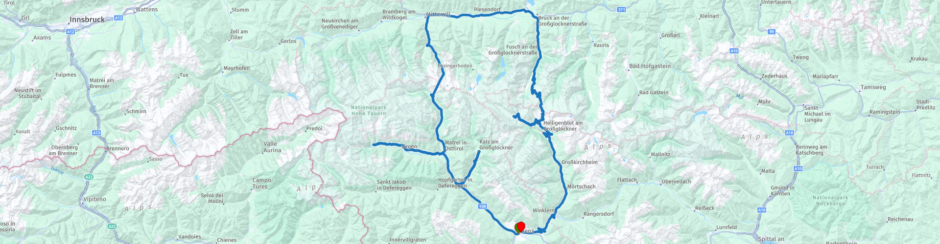
Lienz - Huben - Kals - Huben - Matrei - Virgental - Matrei - Felbertauern - Mittersill - Bruck an der Glocknerstrasse - Grossglockner High Alpine Road - Kaiser-Franz-Josefs-Höhe - Heiligenblut - Winklern - Iselsberg - Lienz
 Share this route


Animation

Verdict


Duration
4h 47m

Mode of travel
Car or motorcycle

Distance
259.99 km

Countries

 RouteXpert Review
 The route has been carefully compiled for use in TomTom, Garmin and MyRoute app navigation.
Beautiful wide winding roads, the Grossglockner High Alpine Road is due to the wide path suitable for beginners. Here you can learn how to take hairpin turns (36). Only the highest route to the Edelweisspitze is not recommended for beginners in heavy traffic or wet weather, due to the cobblestone street. You can safely ignore them The tour falls under the category "medium" (Austria uses "easy, medium and hard"). Sufficient stops on the way with a nice view or to eat or drink. This tour gets 5 stars.
From the East Tyrolean district town of Lienz, it goes through the Iseltal direction Huben. There, the first detour to Kalsertal is recommended. After about 550 hm you reach Kals and on the toll Kalser Glocknerstraße (costs 5 euro but often there is no one) to reach the Lucknerhaus, where there are beautiful views of Austria's highest mountain (RP 3), the Grossglockner.
Next destination is Matrei and here it is worthwhile to make another detour to Virgen (RP4). The uppermost section of this valley is the Umbaltal with the Umbal waterfalls. Starting from the parking Ströden, which is accessible via the community Prägraten am Großvenediger, you can go to the Umbal Falls. Either on foot or, quite idyllically and originally, by horse-drawn carriage. Once there you will find a variety of nature lovers, because the Umbalfälle are far more than just a popular destination. The Umbalfälle also have symbolic value. They can stand for the beauty of the Hohe Tauern National Park. There is hardly a place where you can get so close to the essence of a glacier creek.
Back in Matrei it goes in a northerly direction over the 36.3 km long, opened in 1967 Felbertauernstraße and through the 5.3 km long Felbertauerntunnel in the province of Salzburg. About Mittersill it goes along the Salzach to Bruck. There turn right onto the 48 km long and with 36 bends Großglockner High Alpine Road, which was opened in 1935. A nature and driving experience of a special kind awaits you. The highest point at 2,571 m is the Fuscher Törl / Edelweißspitze (RP12), from where you have a wonderful panoramic view of more than 30 three-thousanders. Continue through the Hochtor (2,503 m) to Carinthia to Franz-Josefs-Höhe, a popular destination. Here you have a magnificent view of the Grossglockner (3,798 m) and the longest glacier of the Eastern Alps, the Pasterze (RP16). Dozens of groundhogs frolic right next to the visitors and with a little luck you will also see the impressive ibex.
Then it goes downhill to Heiligenblut with its well-known and very worth seeing Gothic pilgrimage church with adjoining mountaineering cemetery. Through the Mölltal, past thundering waterfalls (RP20), it's off to Winklern and on the Iselsberg you can get back to East Tyrol.
** Toll: On the initiative of motorcycle country Carinthia, a combined ticket was launched on the panoramic road ticket Carinthia, which gives the motorcyclist a price advantage in the 5 panoramic roads. Grossglockner High Alpine Road, Nockalm Road, Villacher Alpenstraße, Goldeck Panoramastrasse and Malta Hochalmstraße are integrated into this ticket. A ticket consists of four sections, each street corresponds to one section (exception: Großglockner High Alpine Road, two sections). This inexpensive advantage card is available as overnight guest exclusively at all motor hotels. (2019: 37.50 euros).
Motorradland Kärten, the tour is located in the following protected areas: Hohe Tauern National Park


 Links
Links  Usage
Usage Want to download this route?
You can download the route for free without MyRoute-app account. To do so, open the route and click 'save as'. Want to edit this route?
No problem, start by opening the route. Follow the tutorial and create your personal MyRoute-app account. After registration, your trial starts automatically.  Disclaimer
Use of this GPS route is at your own expense and risk. The route has been carefully composed and checked by a MyRoute-app accredited RouteXpert for use on TomTom, Garmin and MyRoute-app Navigation.
Changes may nevertheless have occurred due to changed circumstances, road diversions or seasonal closures. We therefore recommend checking each route before use.
Preferably use the route track in your navigation system. More information about the use of MyRoute-app can be found on the website under 'Community' or 'Academy'.