3 From Hochgurgl in Austria to Trafoi in South Tirol Italy

This route was brought to you by:
RouteXpert Guy Heyns - Adv. RouteXpert
Last edit: 10-12-2024
 Route Summary
 En die 'pleasuredome' begint al meteen wanneer je het hotel verlaat voor deze derde route uit de 'Alpen en Dolomieten 2020' routecollectie.
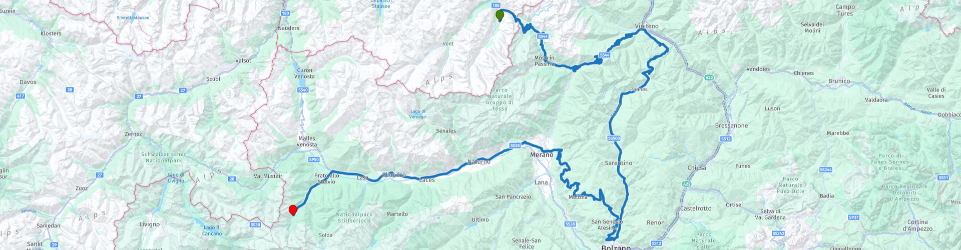
Het Top mountain museum ligt amper 1.5 kilometer van je af en de Timmelsjoch Hochstrasse brengt je al naar de top van de Passo Rombo na amper 8 kilometer.
De Passo Giovo volgt naadloos, alsmede ook de Passo di Pennes die, zo lijkt het wel, als het dessert wordt geserveerd van deze uitstekende brunch...
Na de brunch brengt de route je via de contouren van Bolzano naar de voet van de Stelvio waar u zich wederom in de beste omstandigheden kan voorbereiden op de geweldige 4de rit van deze collectie. Neemt u vast en zeker uw rust... u zal het nodig hebben de volgende dag, wanneer we de trip richting Dolomieten inzetten en we enkele wereldberoemde passen onder de wielen door laten schuiven.
 Share this route


Animation

Verdict


Duration
7h 11m

Mode of travel
Car or motorcycle

Distance
251.54 km

Countries


 RouteXpert Review
 In any case, it is certain that with this route you will be fully in the motor playground, offered by Austria and Italy.
If viewing the route itself already requires a bowl under your mouth, then this description will not improve it. On the contrary, keep the highly absorbent wipes handy and even this route is not yet the queen of the collection to which this ride will be added.
The moment you leave the hotel, you are already on the Timmelsjoch Hochalpenstrasse. In fact, after just 1.5 kilometers you will already reach the Timmelsjoch tolgate, where the Top Mountain Motor museum is also located. The museum opens early in the morning at 9 am, so you know where to go after breakfast. 230 classic motorcycles are presented here in a hypermodern museum on top of the Timmelsjoch.
You can of course, after paying at the toll booth, also decide to continue straight away so that after 8 kilometers you reach the top of the Timmelsjoch Hochalpstrasse and with it the border with Italy. Then of course a nice descent follows with enough parking spaces to make a stop every now and then and to shoot a picture where you like it.
Just after Moso in Passiria, a village between rp 4 and 5, you will find - if you like - some waterfalls. They are marked on the route and you are free to choose whether or not to visit them.
After route point 5 you start the ascent of the Jaufenpass or the Passo Giovo (rp6). Very nice to do, just like the descent which is a bit more gradual. You continue to drive on the flanks of the Gastjochl and then later on the Passo di Penne (rp 7) via the flanks of the Weisse Wand, Zinseler and Hühnerspiel.
After the Passo di Penne you drive into the valley of the Tevere Talvera to slowly ripple towards Bolzano.
At route point 8 you are already 135 kilometers in the saddle and it might be nice to share the experiences with colleagues during a nice break. You can take it here, or 10 kilometers further on the route, at RP 10 where there are also two nice places to enjoy lunch and where a short break is possible. However, it is best to refuel - if necessary - at RP 8. You leave the route in the direction of Bolzano for a short while to find a first petrol station fairly quickly.
After the leisurely journey to Bolzano, where there is not much exciting to be found, except for the magnificent views of the mountains around, we go back into the curved playground in the direction of Merano. This path has been deliberately chosen. Not only to avoid the large freight traffic and the 'crowd', but also because of the nice, nicely winding road. Fun is guaranteed on the back roads to lick your thumbs and fingers, while you can admire the snow-capped peaks around you.
Near Merano, you have no choice and you have to go into the urban area. After route point 15 you are out, but you have to follow the traffic flow towards Trafoi and the Stelvio. Fortunately, it is only 55 kilometers and the track is quite large and smooth, so it will not be long before you reach the finish.
Before that, however, you can take a short break at rp 17 if you take the exit to Parcines. If time and weather permit, you can also take the trip from there, on foot or by shuttle, to the Parcines waterfall (Cascata di Parcines): 100 meters of natural forces with a flow rate of 6000 liters per minute on the peaks of its ability, in the midst of unspoilt nature.
Yes, there is a road leading to it, but keep in mind that the carabinieri are pristine, naturally, strict when you enter this road, which is intended for adjacent roads only.
It will be better and much cheaper to take the walk or use the shuttle.
In any case, this waterfall, one of the most beautiful in the Alps, is highly recommended.
After the waterfall, return to the route and drive the last 55 kilometers in the direction of Trafoi, at the foot of the Stelvio.
The hotel we propose to you on this route is Hotel Madatsch in Trafoi, literally at the foot of the Stelvio. It is a 4-star hotel that pampers not only you, but also your motorcycle (garage). Extensive spa and hammam facilities are available for yourself, as well as an excellent international restaurant.
The route is nicely balanced, so that, even with a long break, photo and 'waaw' moments, you can reach the finish in a reasonable hour. Much depends, of course, on how long you possibly stick to certain points.
The route certainly deserves a five-star rating in the beginning, with a slight decrease in the kilometers you travel towards Bolzano. There you will have to do without tough cornering. But the part between Bolzano and Merano definitely makes up for that.
The main road between Merano and Trafoi is less exciting, but you can already comfort yourself with the thought that excellent hotel facilities await you in Trafoi and that the famous Stelvio will be waiting for you the next morning.
And weather permitting, the next day awaits you with a more than beautiful ride in the rising sun. Dream wonderfully soft again….


 Links
Links  Usage
Usage Want to download this route?
You can download the route for free without MyRoute-app account. To do so, open the route and click 'save as'. Want to edit this route?
No problem, start by opening the route. Follow the tutorial and create your personal MyRoute-app account. After registration, your trial starts automatically.  Disclaimer
Use of this GPS route is at your own expense and risk. The route has been carefully composed and checked by a MyRoute-app accredited RouteXpert for use on TomTom, Garmin and MyRoute-app Navigation.
Changes may nevertheless have occurred due to changed circumstances, road diversions or seasonal closures. We therefore recommend checking each route before use.
Preferably use the route track in your navigation system. More information about the use of MyRoute-app can be found on the website under 'Community' or 'Academy'.