CARINTHIA Villach Gerlitzer Alpenstrasse Strassburg Gmund Millstadt

This route was brought to you by:
RouteXpert Johan Starrenburg
Last edit: 17-08-2020
 Route Summary
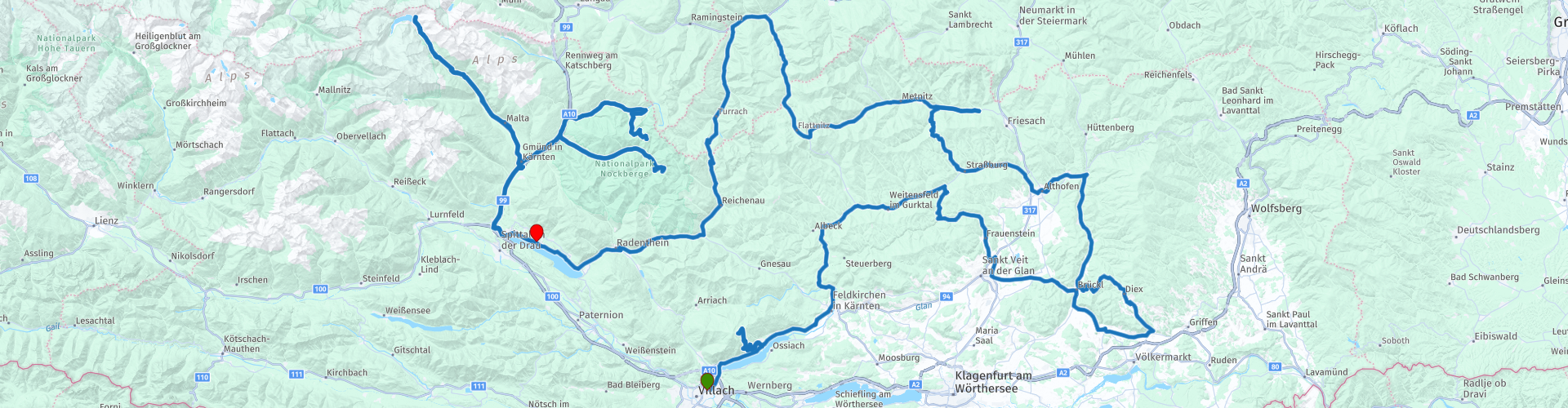
 CARINTHIA
If you are in Carinthia, you have already conquered the Northern Alps.
The Hohe Tauern and the Niedere Tauern form the separation in weather, the enormous cloud formations from which often rain falls do not usually pass beyond the northern flanks of those mountain ranges.
That means you have stable weather here. The southernmost state of Austria is in any case the place where the sun shines most often. And there is not a single motorcyclist
sorry for that. Also nature is wonderful. Wherever you look, you are always surrounded by picturesque and impressive landscapes that seem to come straight out of a photo book. Pointed peaks rise above round mountain crests, which you can sometimes climb on downright exemplary mountain roads.
Green valleys and meadows also shine in the sunlight, and crystal clear rivers wind through the region. Another top attraction is of course the lakes, which you will find in abundance here.
This also includes inviting boulevards along the water, which offer beautiful views and numerous swimming options.
So don't forget to bring your swimsuit. But perhaps the greatest asset of Carinthia is that the people here clearly have a heart for motorcycles.
Many other regions seem to be doing everything they can to ruin our driving pleasure by blocking roads and imposing all kinds of punitive measures, but in Carinthia even the people of the tourist office take up motorcyclists - many others can do the service they provide take an example.
Tour duration: because of the many cultural attractions and beautiful landscapes, you should spend at least two to three days.
Features: This tour through Central Carinthia is easy in itself and despite the high mountain runs, novice mountain riders will have no problem with it.
The tour mainly follows secondary roads that are sometimes very narrow. Especially in the spring you should pay close attention to the road surface.
The frost can damage the road surface and if a lot of traffic passes over it, gravel and dirt can make the road dangerous.
This route is worth 5 stars because of the quality of the roads, the beautiful landscape and rich historical places that you can visit along the way although the quality of the roads is not always 100%.
 Share this route


Animation

Verdict


Duration
11h 22m

Mode of travel
Car or motorcycle

Distance
529.27 km

Countries

 RouteXpert Review
 Villach a proud cozy town in Carinthia ,east of the Dobratsch, where the Gail and the Drau meet.
Its favorable location has brought prosperity to the city for centuries, at the crossroads of the Salzburg - Venice and Graz - Liens - Bolzano routes.
German, Italian, and Slavic influences have brought the sr = tad its charm. And the center, with the pedestrian streets around it, invites you to shop and stroll.
Museums ensure that there is plenty to experience here even in bad weather. Think of museums with oldtimers, city history and the large 3D relief of Carinthia
Moreover, Villach is a great starting point, because from here you can explore some of the most beautiful roads in Carinthia.
---------- RP3 Gerlitzer Alpenstraße
One of those roads starts in Bodensdorf, on the Ossiacher See, the road goes to the top of the Gerlitzen, hence the name Gerlitzer Alpenstraße.
It is a dead-end asphalt toll road (8 euros per vehicle) and stops at the height of a hotel parking lot at an altitude of 1720 meters.
14 kilometers of excellently constructed hairpin bends and 14 percent incline rates. The name Gerlitzen is derived from the Slovenian word 'goreti', which means 'to burn'.
This indicates that special fires were often lit in this region and that is why the Gerlitzen is also called the 'Fire Mountain'.
The geographical center of Carinthia is 1200 meters away. Unfortunately, you can only get there via a walking path.
Back at the lake, the B94 takes you to the busy Feldkirchen where you best avoid the center.
Take the Gurktaler Straße (B93), to the north and turn onto the secondary road (L80) which takes you into gentle turns to the Goggausee.
Beyond the lake, on the Goggausee Landesstraße, there are a lot of beautiful, sharp curves where the forest provides shade to Gurktal, with the mountain range, the Gurktal Alps, in the northwest.
---------- RP04 Gurk
Motorcyclists often ignore churches as places of interest. Maybe this tour is an opportunity to change that. The first opportunity for this is one of the cultural highlights on this route - the cathedral of Gurk with its striking twin towers visible from far away. to which a monumental cathedral has been added three generations later. The result: the pillar basilica has a beautiful, still original portal and beautiful gothic stained glass windows and frescoes.
The oldest and most sacred part is the 100-column crypt containing the grave of the patroness of the state.
---------- RP06 Burg Hochosterwitz
We continue the route via the 67. A narrow road with many curves but little traffic. This takes us via the Pisweger Sattel pass to St. Veit an der Glan.
Just past this town, you pass another symbol of Carinthia on the right: Burg Hochosterwitz.
The castle rises high above the surroundings and stands on a 150-meter high limestone rock. If you want to visit the castle it is a 620-meter long walk via a steep road.
At the top of the castle, we see an inner courtyard with arch gallery, an old well, and the castle museum with armor.
With your motorcycle suit on, the climb takes a lot of time, but it pays off. Less sporty? Take the elevator up. The castle was first mentioned around 860.
The castle has been in the possession of the noble Khevenhüller family since 1541 but has long been converted into a museum and is open to the public.
---------- RP08 Diex
After this, we will set our sights on Hamburg. Take the L113, a lovely road that leads to Diex, a village at an altitude of 1159 meters, and said to be Austria's sunniest spot. The winding descent to Brückl offers beautiful views and is well worth the detour. Then you follow the Görtschitztal to the exit to Althofen and you reach the eastern edge of the Gurk Valley. Along the way, you will pass the early-classical Schloss Pöckstein, a residence of the bishops of Gurk.
---------- RP11 Strasbourg
Further west we find Schloss Straßburg wrathing high above the road and originally this was the primary residence of the bishops of Gurk. In the 18th century, the castle was severely damaged in an earthquake, was abandoned, and was left to decay for 200 years. Large-scale restoration work only started in 1950. large parts of the castle were restored. After this, we cross the Gurktal Alps. A winding, narrow road that connects the Gurktal with the Metnitztal.The road has had its best time, so watch out for cracks and stones. Still enjoy the road, especially the last kilometers, in the descent to Marienheim.
--------RP 13 There is an unsightly sign that you can make a detour to the east, to the beautiful Car and Motorcycle Museum at Landhotel Seppenbauer in St. Salvator. Gerhard Porsche's private collection is fantastic and even people who have absolutely no feeling for technology dream here.
Everything here tells a piece of motorized history, from the very beginning of motor-powered mobility over the 'Rockin' Fifties' to the present day. Drive back to Marienheim and continue to follow the pretty Gradeser Straße.
---------- RP14 Metnitz
In Metnitz, a large, rusty sculpture looks down on you while passing. It represents a dead ship and refers to an old custom: the dance of death. You might decide to visit the Metnitser Totentanz museum. Further on you can widness how many different types of road surfaces there are. We set coarse to the Flattnitzer Höhe where you drive on just about every conceivable road surface. But the road runs at an altitude of 1400 meters, it is not busy and it is wonderful to be on it to drive. As of now there are fewer mountains and we mainly drive through valleys, Small roads wind along streams and rivers almost everywhere.
---------- RP15 Stadl an der Mur
Shortly afterward you will leave beautiful Carinthia because when you reach the Murtal, you will have arrived in Styria. We turn left in the town of Stadl an der Mur. Do not get confused by local signposts. Stadl an der Mur merged on 1 January 2015 with Predlitz, which is more than six kilometers further west. The two villages are very idyllic on the
upper reaches of the Mur and together form the municipality of Stadl-Predlitz.
Via another beautiful road, we head south again, back to Carinthia.
---------- RP16 Turracher Höhe
We do this via the Turracher Höhe, a plateau, and at the same time also the impressive pass that forms the border between Styria and Carinthia. The pass is located at an altitude of 1763 meters, the road there is about two kilometers long and leads to Turrach and the scenic Turracher See. You can go even higher, but not with the engine. A gondola rocks you from the lake to 2000 meters. Above that, you can enjoy a 360 ° panoramic view of the wider area. The southern slope of the Turracher Höhe is technically the most challenging. The road is in good condition, but with a gradient of more than 20 percent, this is a wonderful ride.
---------- RP17 Nockalmstraße
And the driving pleasure is still not over. On the south side of the Turracher Höhe, just before the town of Ebene Reichenau, you have on the right the Nockalmstraße, a legendary road. With its maximum gradient of 23 percent, it is one of the steepest roads in Carinthia. Motorcyclists have to pay 18 euros toll, but that is a treat that you should definitely give yourself. Over a distance of 57 kilometers, you will encounter 52 sharp bends that are beautifully integrated into the separate landscape of the Nockberge National Park. The round rock tops are geological rarities, they are older than the surrounding mountain ranges and contain many soil resources. The many blast furnaces, which are now out of use, indicate that this was a mining area. Nockberge National Park is best known for its large larch and alpine pine forests.
--------RP19 The 2042 meter high Eisentalhöhe is the highest point. Then you descend almost 500 meters, but at the Schiestelscharte the Nockalmstraße almost climbs again to 2000 meters.
When you pay the toll, you also get a lot of information about the almost 1500 square kilometer biosphere park and its nature, which can also tempt bikers to discover trips but only between 8 and 6 pm, because motorcycles are not allowed on this route outside. At the Eisentalhütte there is a Biker's Point with lockers for helmets and valuables, so you can enjoy the surroundings without having to carry too much ballast. After Nockalmstraße you drive west and then it goes straight to one of the best-preserved medieval cities in Austria.
---------- RP 20 -23 The almost 15 kilometers long toll road (motorcyclists pay 11.50 euros) through the Maltatal takes you to the highest dam in Austria. Expect a big climb, because the mountain road starts at 911 meters and brings you to the Kölnbreinsperre dam at 1933 meters. One of Austria's most spectacular mountain roads, Malta Hochalmstraße takes you through six mountain-cut tunnels, several sharp turns, and past a lot of waterfalls that dry up at night as theThe Malteiner Wasserspiele are particularly impressive. Not afraid of heights? Then take the Airwalk, near the dam.
---------- RP25 Gmünd
Gmünd is located at the confluence of Malta and the Lieser. The city's territory extends to the foothills of the Hohe Tauern National Park in the west and to the Nockberge National Park in the east. Gmünd has a rich history and probably originated between the 11th and 12th centuries as an outpost of the Archdiocese of Salzburg and was supposed to protect the Katschbergsattel against the Duchy of Carinthia. In 1346 Gmünd was granted city rights, making it the oldest city in modern Carinthia after Friesach. A remnant of that period is the Salzburg dialect of the local population, which is mainly spoken in the Katschtal, the highest valley in the Lieser basin. The Porsche Museum in Gmünd is definitely worth a visit. Ferdinand Porsche worked here from 1944 to 1950 and the first true Porsche - the legendary 356 - originated here. The factory here produced 44 coupés and eight convertibles. In 1982 antique dealer Helmut Pfeifhofer opened the first opposite the former factory.
---------RP 26 Millstatt
The route ends at the Millstätter See is the second largest lake in Carinthia, after the Wörthersee. With its depth of 141 meters, it is the deepest lake and the lake that contains the most water. It is 12 kilometers long and is located at an altitude of 588 meters. The water has the quality of drinking water and in the middle of summer it heats up to 26 degrees. Perfect for swimming.
Around 1070 a Roman Benedictine monastery was built in Millstatt. For centuries the monastery was the religious and cultural center of Oberkärnten and it was one of the largest in Carinthia. The monastery no longer has a religious function, but culturally you will still enjoy it here.


 Links
Links  Usage
Usage Want to download this route?
You can download the route for free without MyRoute-app account. To do so, open the route and click 'save as'. Want to edit this route?
No problem, start by opening the route. Follow the tutorial and create your personal MyRoute-app account. After registration, your trial starts automatically.  Disclaimer
Use of this GPS route is at your own expense and risk. The route has been carefully composed and checked by a MyRoute-app accredited RouteXpert for use on TomTom, Garmin and MyRoute-app Navigation.
Changes may nevertheless have occurred due to changed circumstances, road diversions or seasonal closures. We therefore recommend checking each route before use.
Preferably use the route track in your navigation system. More information about the use of MyRoute-app can be found on the website under 'Community' or 'Academy'.

Styria
About this region
Styria (German: Steiermark [ˈʃtaɪɐˌmaʁk] (listen); Croatian and Slovene: Štajerska; Hungarian: Stájerország) is a state (Bundesland) in the southeast of Austria. With an area of 16,401 km2 (6,332 sq mi), Styria is the second largest state of Austria, after Lower Austria. Styria is bordered to the south by Slovenia, and clockwise, from the southwest, by the Austrian states of Carinthia, Salzburg, Upper Austria, Lower Austria, and Burgenland. The state capital is Graz.
Read more on Wikipedia
View region
 Statistics
  6
6Amount of RX reviews (Styria)
 11521
11521Amount of visitors (Styria)
 1072
1072Amount of downloads (Styria)
 Route Collections in this region
 The 24 Most Beautiful Alpine Routes
The Alps, The Alps are a mountain range in Europe, stretching from the French Mediterranean coast in the southwest to the Pannonian Plain in the east. The area of the mountain range is more than 200,000 km².
In other words Passes and Mountain Roads!
Driving through the mountains is great! Especially over the mountain passes with hairpin bends and narrow winding roads. Every bend a different view where you can enjoy. There are many beautiful mountain passes in the Alps.
A selection that has also been incorporated into these routes:
The Stlevio Pass:
The Stelvio Pass, also known as Passo dello Stelvio, is mainly known for the stage in the Giro d'Italia. Due to the length and the difference in height, this pass is seen as one of the toughest tests in cycling. The Stelvio Pass reaches a maximum height of 2758 meters and is therefore one of the highest in the Alps. The pass connects the towns of Bormio and Prato Allo Stelvio. In winter the pass is closed due to heavy snowfall.
The Reschenpass:
The Reschenpass, also known as Passo di Resia, connects the Austrian state of Tyrol with the Italian province of South Tyrol. The pass reaches a maximum height of 1,504 meters and has been one of the most important north-south connections in the Alps in recent centuries. The pass was used long before Roman times. Along the way you will pass several highlights and historical relics. One of the highlights is the Reschensee. This lake was created after the construction of the dam and has completely submerged the village of Graun. The only thing that reminds of that is the clock tower in the middle of the lake.
Col du Galibier:
The French mountain pass Col du Galibier connects the towns of Saint-Michel-de-Maurienne and Briançon via the Col du Lautaret in the south and the Col du Télégraphe in the north. The mountain pass is part of the Tour de France and very much feared, due to the fact that it can only be reached via the other two mountain passes. The pass reaches a maximum height of 2646 meters. From there you can take a walk to the viewpoint at 2704 meters. You can admire the peaks of the Grand Galibier, Mont Blanc and La Meije here.
The Grossglockner High Alpine Road:
With a height of 3798 meters the Grossglockner is the highest mountain in Austria. To fully enjoy this impressive mountain, you can drive over the Grossglockner High Alpine Road and the accompanying pass. The route starts from Bruck am Grossglockner and ends in Heiligenblut. Of course you can drive in two directions. The pass reaches a maximum height of 2504 meters and is closed in winter due to heavy snowfall. Along the way you pass several stops with fun activities, information points, mountain huts and viewpoints. A visit to the Kaiser-Franz-Josefs-Höhe and Pasterzen Glacier is highly recommended.
The Col d'Izoard:
Just like the Col du Galibier, the Col d'Izoard is also part of a stage of the Tour de France. The mountain pass connects Briançon with the valley of the river Guil. The pass is partly located in the Regional Natural Park du Queyras and reaches a maximum height of 2360 meters. What is special about the Col d'Izoard is the barren and rocky landscape. Sometimes it feels like driving a car over the moon! Along the way you can stop at several points to enjoy the beautiful view.
The Bernina Pass:
The Bernina Express is one of the most famous rail trains in Switzerland and the Alps. The route is beautiful and partly included on the UNESCO World Heritage List. Parallel to the railway lies the Bernina pass, which connects the Veltlin valley with the Egandin valley. This beautiful Alpine road has a total length of 56 kilometers and reaches a maximum height of 2328 meters. Along the way you can enjoy views of the Morteratsch Glacier.
The Sella Pass:
The Sella Pass, also known as Passo di Sella, takes you over one of the most impressive mountain ranges in the Dolomites: the Sella massif. The pass connects Valle di Fassa with Val Gardena and reaches a maximum height of 2236 meters. At this height is also the border of the Italian provinces of Trentino and Bolzano. Along the way you can enjoy the view of this spectacular mountain world. Admire, for example, the three peaks of the Sasso Lungo massif, the Sella massif or the peaks of the Marmolada. You can also drive the Sella pass in combination with the Gardena pass, Pordoi pass and Campolongo pass.
The Grimsel Pass:
The Grimsel Pass connects Goms in Wallis with the Halis Valley in the Bernese Oberland. The pass reaches a maximum elevation of 2165 meters and is closed in winter due to snowfall. Over the centuries, the mountain pass has played an important role in trade between Switzerland and Italy. Now it is mainly the reservoirs that have an important function. These are used to generate electricity. The landscape you drive through is rugged, rocky and impressive. On top of the pass is a hotel and a restaurant with a special marmot park. The Dodensee (Totensee) is also located here. This lake owes its name to the many soldiers who died in the time of Napoleon.
The Gotthard Pass:
The Gotthard Pass, also known as Passo del San Gottardo and Saint Gotthard, connects the Swiss towns of Airolo and Andermatt. The mountain pass and associated tunnel are especially known among holidaymakers driving from Switzerland to Italy. But where the majority opt for the tunnel, it is precisely the pass that really completes the holiday. The Gotthard Pass has a length of about 26 kilometers and reaches a maximum height of 2106 meters. The route is beautiful and takes you along old villages and beautiful views.
The Silvretta High Alpine Road and Silvretta Pass:
The Paznaun Valley in Tyrol and the Montafon in Vorarlberg are connected by the Silvretta High Alpine Road. The route has a length of 22.3 kilometers and leads from Galtür to Partenen in 34 hairpin bends, via the 2032 meter high Bielerhöhe. The Silvrettasee is also located at this point, where you can enjoy a lovely walk. The pass is closed in winter due to snowfall.
The Simplon Pass:
Just like the Gotthard Pass, many holidaymakers also travel over the Simplon Pass every year. This mountain pass connects the Rhone Valley in the canton of Valais with the Valle d'Ossola in Piemonte. The pass is open all year round and reaches a maximum height of 2005 meters. Along the way you pass a number of buildings, including the well-known Simplon Hospiz from 1825. The hospiz is managed by the monks of St. Bernard. From the highest point on the pass, all kinds of hiking routes are possible and you will also come across a hotel where you can spend the night.
The Gerlos Pass:
The Gerlos Pass connects the Salzach Valley in the Salzburgerland with the Zillertal Valley in Tyrol. The pass is part of the Gerlos Alpenstraße and runs right through the Hohe Tauern National Park. Along the way you can enjoy beautiful views of the surroundings. The pass has a length of 12 kilometers and reaches a maximum height of 1531 meters. A ride over the Gerlos Pass can be ideally combined with a visit to the Krimmler Wasserfälle.
The Great St. Bernard Pass:
The Great St. Bernard Pass, better known as Col du Grand Saint Bernard, connects the Italian province of Valle d'Aosta with the Swiss canton of Valais. The pass is one of the highest in Switzerland and reaches a maximum height of 2469 meters. Like a number of other mountain passes in this list, the Great St. Bernard Pass has also been used as a connecting road for centuries. The pass is named after the St. Bernard dogs that used to help stranded travelers along with the monks. The pass is closed in winter.
The Timmelsjoch High Alpine Road:
The Timmelsjoch High Alpine Road connects the towns of Sölden in the Ötztal and Meran in South Tyrol. Tolls must be paid on the Hochgurgl - Moos route. Via a mountain road with about 60 hairpin bends you drive through a beautiful mountain world. With the Timmelsjoch Experience you can learn more about the history, the road and the environment via various stations. You can also visit the Top Mountain Crosspoint museum.
Col de l'Iseran:
With a maximum pass height of 2770 meters, the Col l'Iséran is one of the highest mountain passes in the Alps. The pass connects Bourg-Saint-Maurice with Bonneval-sur-Arc. Via a road full of hairpin bends you pass, among other things, Val-d'Isère and a side valley of the Maurienne that lies entirely in the National Park de la Vanoise. You can spot animals such as marmots and chamois and there is also a restaurant with a chapel on top of the pass.
The Gavia Pass:
The Gavia Pass (Italian Passo di Gavia) is a mountain pass in the Italian Alps, in the Lombardy region.
It is one of the highest pass roads in Europe. The road leads through the unspoilt Stelvio National Park. The road was built in the First World War to supply Italian soldiers who fought in the Italian-Austrian border area. The pass height is one of the most beautiful in the Alps. Here is the large Lago Bianco with, to the north, the mountain San Matteo (3684 meters). Lago Nero is slightly lower on the south side of the pass. Here the mountain group of the Adamello determines the view. There are many well-marked walks in the area. During the winter the pass is closed due to the heavy snowfall. The pass is often closed until May and June due to the large amount of snow.
Promoter has made a selection of the 24 Most Beautiful Alpine routes that they have set out in recent years.
The routes go through:
France
Austria
Switzerland
Italy
The most beautiful roads, the most beautiful views, the most beautiful viewpoints. The highest mountains, the fastest descents, hairpin bend after hairpin bend, you name it you can't get enough of it.
If you go on holiday in this region, take advantage of it, ALL routes in this collection have been checked and made equal for TomTom, Garmin and MyRoute-app Navigation by a MyRoute-app RouteXpert.
Have fun with this collection and while driving one of these routes. Enjoy all the beauty that the Alps and the Dolomites have to offer. Click on “View route” to read the review of the chosen route.
I would like to hear your findings about the route(s).
View Route Collection
The 12 most beautiful car and motorcycle routes in Carinthia
“Motorradland Kärnten” where you feel so wonderfully welcome as a motorcyclist!
Own website for motorcyclists, own curated routes, hotels, campsites and guest houses with attention for motorcyclists, a wonderful area where motorcyclists are very popular.
Kärnten or Carinthia, at the crossroads of the Germanic, Slavic and Roman worlds. Three cultures within a few kilometres, southern flair, culinary delights, cross-border tours. Breakfast in Italy, lunch in Slovenia, dinner in Austria - all in one day. Experience the diversity in the borderless Alps-Adriatic region, the area for motorcyclists.
Extensive day trips on winding mountain paths, romantic panoramic routes and beautiful lakes, here the 12 TOP routes Kärnten / Carinthia. Enjoy!
View Route Collection