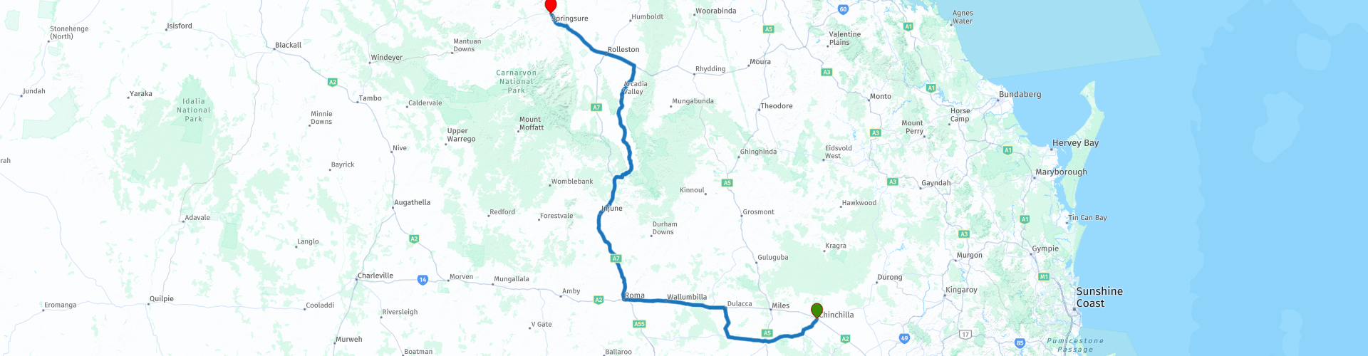
R10 QLD Chinchilla to Springsure

This route was brought to you by:
RouteXpert Hans van de Ven (Mr.MRA)
Last edit: 19-04-2021
 Route Summary
 Australia is very large; 8 million km2, which is more than 226 times larger than the Netherlands! Has a diversity of flora and fauna; the most diverse types of plants, trees and animals, especially birds and a lot of typical Australian marsupials, which you will not find anywhere else in the world!
Enjoy all the beauty immensely: From the evergreen tropical rainforests, to the vast Outback; from the desert to the countless and peaceful idyllic palm beaches; from the winter sports areas in the southeast to the vibrant and impressive metropolis of Melbourne, Sydney and Perth.
You will see it all and experience it in this amazing tour through Australia, a tour to remember!
Starting point: Chinchilla, Downtown Motor Inn
End Point: Springsure, Dooleys Tavern & Motel
The route has been created for TomTom, Garmin and MyRoute-app Navigation users.
ATTENTION: DRIVE LEFT!
 Share this route


Animation

Verdict


Duration
9h 8m

Mode of travel
Car or motorcycle

Distance
587.93 km

Countries

 RouteXpert Review
 Today, Springsure is a pastoral settlement with cattle ranches and sunflower, sorghum, wheat, and chickpea plantations. Springsure is the hub for several coal mines such as the Minerva mine and the Rolleston mine. It is also a stopping point for expeditions to Carnarvon National Park.
Gangalu (Gangulu, Kangulu, Kanolu, Kaangooloo, Khangulu) is an Australian Aboriginal language spoken in Gangula country. The Gangula language area includes the towns of Clermont and Springsure that extend south towards the Dawson River.
Wadja (also known as Wadjigu, Wadya, Wadjainngo, Mandalgu and Wadjigun) is an Australian Aboriginal language in Central Queensland. The language area includes the local administrative areas of the Aboriginal Shire of Woorabinda and the Central Highlands Region, including the Blackdown Tablelands. the Comet River and the Expedition Range and the towns of Woorabinda, Springsure and Rolleston.
The city takes its name from a pastoral running name used from 1861, so named because of a permanent spring on the run. The area was originally occupied by Aboriginals for thousands of years.
You can do some shopping at the supermarket in Chinchilla, immediately after departure, so that you have something to eat and drink with you on the way.
The first stop is at the Chinchilla Weir, the Chinchilla Beneficial Use Scheme gets its water from Chinchilla Weir, located on the Condamine River. It supports irrigation along the floodplains of the river and complements the city water supply for Chinchilla. Then you go to Condamine, this is a town in the Western Downs region. At the 2016 census, Condamine had a population of 384. Condamine is believed to be the site of the invention of the 'Condamine Bell', a small bubble made of sheet steel used to locate herds of livestock.
For a cup of coffee you can stop in Wallumbilla at Calico Cottage, this town has about 230 inhabitants and is one of the smaller cities in Australia. Wallumbilla is located at an altitude of about 318 m above sea level. After coffee it continues to Roma, this city has about 5,900 inhabitants and is a medium-sized city for Australia. Roma is located at an altitude of about 301 meters. Here you can also have lunch in one of the many restaurants. After lunch, head north to Injune, with a population of around 390, Injune is one of the smaller towns in Australia. Injune is located at about 394 meters above sea level.
After Injune, exit the Carnarvon Highway and turn into Arcadia Valley Road. This contains a stretch of +/- 40 KM unpaved road. In Rolleston you return to the Carnarvon Highway, where you can refuel and eat or drink something.
From Rolleston, head towards the terminus in Springsure, this town is one of the smaller towns in Australia. Springsure is about 328 meters above sea level.
This 4-star rated route, you mainly go on beautiful roads, but also a lot unpaved. You pass through nature reserves and some nice places, where you can stop for a snack or to refuel.
General info:
Queensland (literally translated: Queensland) is a state in northeastern Australia. Queensland is the second largest in area and Australia's third largest state in terms of population. The state was named after Queen Victoria, the monarch at the time of the settlement of the former colony. The capital and largest city of Queensland is Brisbane, located in the southeast of the state. The northern portion of the state, separated by the Tropic of Capricorn, is tropical. The south is subtropical. Queensland was originally a British crown colony that emerged in 1859 after secession from New South Wales. The city of Brisbane originally started as the Moreton Bay penal colony, which held convicts who again committed errors while serving their sentences in New South Wales.
Brisbane is located about 100 kilometers north of the border between Queensland and New South Wales. Southeast Queensland also has two larger population centers: the Gold Coast south of Brisbane, and the Sunshine Coast north of Brisbane. Along the approx. 2000 km long coast (from south to north) are the following cities: Coolangatta - Gold Coast - Brisbane - Sunshine Coast - Gympie - Maryborough - Hervey Bay - Bundaberg - Gladstone - Rockhampton - Mackay - Townsville - Cairns. The following cities are inland (counterclockwise): Warwick - Toowoomba - Roma - Charters Towers - Mount Isa. The world's largest city by surface, Mount Isa is located in northwestern Queensland. The area of the city is 42,904 km² (approximately the area of the Netherlands!), But the city has a population of approximately 20,000 (2003).
The state is home to five World Heritage Sites: Australian Mammal Fossil Sites (Riversleigh / Naracoorte),
Gondwana rainforests, Fraser Island, The Great Barrier Reef and the Tropical wetlands of Queensland.
Queensland can be roughly divided into three parts:
1.The eastern coastal strip, dominated by the Great Australian Separation Mountains. From north to south there are also the Darling Downs, the Bunya Mountains, the Carnarvon Gorge, the Whitsunday Islands, Hinchinbrook Island and the Atherton Tableland. Off the coast, north of Fraser Island, the Great Barrier Reef begins.
2.The tropical Cape York Peninsula in the north. To the north of this is the Straits Torres with the Straits Torres Islands and to the east most of the Great Barrier Reef.
3 Most of the dry interior, called the Queensland outback, with the Channel Country in the southwest.

 Links
Links  Usage
Usage Want to download this route?
You can download the route for free without MyRoute-app account. To do so, open the route and click 'save as'. Want to edit this route?
No problem, start by opening the route. Follow the tutorial and create your personal MyRoute-app account. After registration, your trial starts automatically.  Disclaimer
Use of this GPS route is at your own expense and risk. The route has been carefully composed and checked by a MyRoute-app accredited RouteXpert for use on TomTom, Garmin and MyRoute-app Navigation.
Changes may nevertheless have occurred due to changed circumstances, road diversions or seasonal closures. We therefore recommend checking each route before use.
Preferably use the route track in your navigation system. More information about the use of MyRoute-app can be found on the website under 'Community' or 'Academy'.