R03 - Maccagno to Sisikon

This route was brought to you by:
RouteXpert Arno van Lochem - Senior RX
Last edit: 30-07-2023
 Route Summary
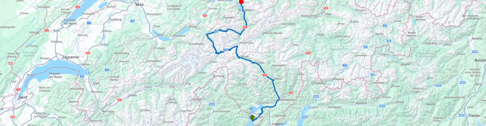
 The start of this route is at Albergo Paradiso on Lake Maggiore. Via a number of well-known passes such as the St. Gotthard Pass, the Furka Pass and the Grimsel Pass, the route ends at the Tellsplatte hotel. This hotel enjoys a truly breathtaking location on Lake Vierwaldstättersee. Sit on the terrace with a wonderfully cooling Weizen and enjoy the view. Then you almost think "I'm never leaving here!"
The route is for the more advanced motorcyclist given the occasional tight hairpin bends in the Alps. Good engine control is desirable!
This route is part of the collection 'From Innsbruck to Holland in 7 days', see section 'Links' under the photos.
 Share this route


Animation

Verdict


Duration
5h 59m

Mode of travel
Car or motorcycle

Distance
271.59 km

Countries


 RouteXpert Review
 The route starts at Albergo Paradiso on the beautiful Lago Maggiore. You don't get the chance to warm up the bike first, after 350 meters you turn into a narrow, steep street in the center and the climbing is blown. In a short time you climb to a height from which you have a beautiful view over Lake Maggiore.
A little further on, you drive over today's first pass, the Passo dell'Alpe di Neggia, lying at an altitude of 1,395 meters. Not a particularly high pass, but still a beautiful view of the surrounding peaks on top. Definitely worth a moment for a photo.
At the bottom of the descent you drive again along the waterline of Lake Maggiore. At Bellinzona, TomTom does not understand that you can just go straight ahead and turns right into a small road. Don't turn off, just drive straight ahead. Garmin does give the correct indication.
A few kilometers further you reach Biasca. Since you have already covered almost 75 kilometers, it is time for coffee. This is possible at hotel Svizzero, a small but good hotel where they serve delicious coffee.
After coffee, you set course for the beautiful Gotthard Pass. Look out for a while at the second roundabout after Biasca. TomTom clearly indicates the right way ('180 degrees' straight ahead), while Garmin wants you to turn at almost three-quarters of the roundabout. Now that is going to be difficult, because there is a fence. But beyond that lies the old road. If you take the right exit you can immediately turn left onto the old road, but since it is a dead end, you better not do that. Follow the signs 'San Gottardo' then it can hardly go wrong. After just less than 1 kilometer you will see that you are back on the route.
Before you reach the Gotthard Pass you first have the opportunity to visit the waterfall in the river Piumogna. This waterfall has a fall height of 43 meters and is considered one of the most spectacular in this area. It is easily accessible on foot, there are parking lots nearby and it is an unmissable attraction for nature lovers. A suspension bridge over the creek, which gives the name to this wild waterfall, allows visitors to enjoy a natural spectacle of rare beauty in complete safety.
Once you are back on the road you still have about 20 kilometers to go before reaching the Gotthard Pass. Make no mistake, those are 20 beautiful kilometers. Beautiful mountains, nice mountain villages and vast green meadows determine the scenery through which you drive.
At some point you will reach the point where the Gotthard tunnel (17km!) Starts. The routes that run along the top also start there. There is an old and a new part, this climb runs entirely over the old part. Only in the descent do the routes come together at a certain point.
A warning is in order, the pavement of this pass still consists in part of so-called cobblestones, especially in bends. When the road surface is wet, these can be treacherously slippery. With a dry road there is little to worry about, except for the bumping ...
Also pay attention to the higher situated new part of the pass when climbing. The panorama galleries are beautifully visible from the old pass. Only then does it become apparent what a gigantic building this is and what an effort it must have cost.
After the Gotthard you arrive at Hospental, turn left and start the ascent of the Furka Pass. You follow the 19 to Realp. That's where the last part of the climb starts. On top of the pass you have a beautiful view (if the weather cooperates), reason to stop for a few photos.
In the descent you will soon arrive (3rd hairpin bend) at hotel Belvedere. This old hotel is widely known from photos. If you say Furka Pass, you say Hotel Belvedere. Wonderful to stop in the parking lot and take a few pictures.
Another reason to stop here is because if you stand with your back to the hotel in the parking lot, you will see the path that takes you to the Rhône glacier. It's a short walk of approx. 200 meters.
Since the opening of today's Furka pass 150 years ago, thousands of tourists have come to see this unique mountain panorama with the Rhone glacier. Nowadays you park at the Hotel Belvédère and you walk to the ice cave drilled every year. The glacier itself looks white-gray, but in the 100-meter long ice tunnel and in the ice hall, everything lights up in magical subtle shades of blue. The glacier here moves 30 ~ 40 meters per year, sometimes more than 10 cm in a day. Also a lot of ice melts away during the summer; the ice cave is still 100 meters deep at the start of the season, and only 70 meters at the end of the summer. One can enjoy this glacier panorama from the viewing platform and soon also from the platform at the glacial lake. This is because a new glacial lake is created at the foot of the glacier. Take a moment to contemplate this beautiful natural phenomenon!
At the bottom of the pass you come to the mountain village of Gletsch, a hamlet consisting of a large old luxury hotel (royal) with a mountain station and an Anglican chapel. It is part of the village of Oberwald. After being closed for years it has been put back into use as it is considered a monument. Gletsch is deserted in the winter.
After lunch you immediately start climbing the Grimsel Pass. After a number of hairpin bends you arrive at a small lake, the Totesee, located at the top of the Grimselpass. A little further on is the Grimselsee, which is a lot bigger.
To be able to view and photograph the area well, you can turn left just after the water and park at the indicated spot.
A little further there is the possibility to walk over a suspension bridge, the Handeckfallbrücke. The suspension bridge got its name on the one hand because of the place name Handeck and on the other because it crosses several waterfalls. Even though the suspension bridge itself is right next to the valley station of the Gelmerbahn and is also used to cross the motorway below, it is very pleasantly surrounded by beautiful nature and equally well integrated into it. The fact that it is a magnet for suspension bridge fetishists has certainly also been included in the planning of the project.
Some details of the suspension bridge: Wingspan: 70 meters, height: 70 meters and width: 65 centimeters. Bring it on if you dare! And it's free too ...
You continue the route towards Innertkirchen, where the route turns right towards the Sustenpass. This forms the connection between Innertkirchen and Wassen. The pass is located at an altitude of 2,224 meters. The current road was built between 1938 and 1945, making it one of the newer Swiss pass roads. The Susten Pass is rarely used as a transit route and is especially important for tourism. For this reason, the road is not kept free of snow during the winter.
From Innertkirchen the road leads up through the sparsely inhabited Gadmental. The highest point of the route over the Susten Pass is in a short tunnel. There are a few buildings and spacious parking spaces on the Bernese side. The actual Susten Pass can only be reached on foot. The descent takes you through the green Meiental to Wassen. During this descent there is the possibility to stop at Sustenbrüggli for a cup of coffee or something else. This gives you the opportunity to enjoy the Meiental during this break.
From Wassen the route runs over the 2, which meanders along the A2. At Fluelen you can already see the water of the Vierwaltstättersee. A few kilometers further on you turn left for the last time (just before the tunnel!) To arrive at today's end point. That is hotel Tellsplatte in Sisikon. A hotel in a beautiful location with an even better view. Enjoy with a capital G.
Have fun driving this route!


 Links
Links  Usage
Usage Want to download this route?
You can download the route for free without MyRoute-app account. To do so, open the route and click 'save as'. Want to edit this route?
No problem, start by opening the route. Follow the tutorial and create your personal MyRoute-app account. After registration, your trial starts automatically.  Disclaimer
Use of this GPS route is at your own expense and risk. The route has been carefully composed and checked by a MyRoute-app accredited RouteXpert for use on TomTom, Garmin and MyRoute-app Navigation.
Changes may nevertheless have occurred due to changed circumstances, road diversions or seasonal closures. We therefore recommend checking each route before use.
Preferably use the route track in your navigation system. More information about the use of MyRoute-app can be found on the website under 'Community' or 'Academy'.

Bern
About this region
Bern (German: [bɛrn] (listen); Alemannic German: Bärn [b̥æːrn]) or Berne (French: [bɛʁn] (listen); Arpitan: Bèrna [ˈbɛʁna] (listen); Italian: Berna [ˈbɛrna]; Romansh: Berna [ˈbɛrnɐ] (listen)) is the de facto capital of Switzerland, referred to by the Swiss as their "federal city" (in German: Bundesstadt, French: ville fédérale, and Italian: città federale). With a population of about 144,000 (as of 2020), Bern is the fifth-most populous city in Switzerland. The Bern agglomeration, which includes 36 municipalities, had a population of 406,900 in 2014. The metropolitan area had a population of 660,000 in 2000.Bern is also the capital of the canton of Bern, the second-most populous of Switzerland's cantons. The official language is German, but the main spoken language is the local variant of the Alemannic Swiss German dialect, Bernese German. In 1983, the historic old town (in German: Altstadt) in the centre of Bern became a UNESCO World Heritage Site.
Read more on Wikipedia
View region
 Statistics
  24
24Amount of RX reviews (Bern)
 16437
16437Amount of visitors (Bern)
 1751
1751Amount of downloads (Bern)
 Route Collections in this region
 The 24 Most Beautiful Alpine Routes
The Alps, The Alps are a mountain range in Europe, stretching from the French Mediterranean coast in the southwest to the Pannonian Plain in the east. The area of the mountain range is more than 200,000 km².
In other words Passes and Mountain Roads!
Driving through the mountains is great! Especially over the mountain passes with hairpin bends and narrow winding roads. Every bend a different view where you can enjoy. There are many beautiful mountain passes in the Alps.
A selection that has also been incorporated into these routes:
The Stlevio Pass:
The Stelvio Pass, also known as Passo dello Stelvio, is mainly known for the stage in the Giro d'Italia. Due to the length and the difference in height, this pass is seen as one of the toughest tests in cycling. The Stelvio Pass reaches a maximum height of 2758 meters and is therefore one of the highest in the Alps. The pass connects the towns of Bormio and Prato Allo Stelvio. In winter the pass is closed due to heavy snowfall.
The Reschenpass:
The Reschenpass, also known as Passo di Resia, connects the Austrian state of Tyrol with the Italian province of South Tyrol. The pass reaches a maximum height of 1,504 meters and has been one of the most important north-south connections in the Alps in recent centuries. The pass was used long before Roman times. Along the way you will pass several highlights and historical relics. One of the highlights is the Reschensee. This lake was created after the construction of the dam and has completely submerged the village of Graun. The only thing that reminds of that is the clock tower in the middle of the lake.
Col du Galibier:
The French mountain pass Col du Galibier connects the towns of Saint-Michel-de-Maurienne and Briançon via the Col du Lautaret in the south and the Col du Télégraphe in the north. The mountain pass is part of the Tour de France and very much feared, due to the fact that it can only be reached via the other two mountain passes. The pass reaches a maximum height of 2646 meters. From there you can take a walk to the viewpoint at 2704 meters. You can admire the peaks of the Grand Galibier, Mont Blanc and La Meije here.
The Grossglockner High Alpine Road:
With a height of 3798 meters the Grossglockner is the highest mountain in Austria. To fully enjoy this impressive mountain, you can drive over the Grossglockner High Alpine Road and the accompanying pass. The route starts from Bruck am Grossglockner and ends in Heiligenblut. Of course you can drive in two directions. The pass reaches a maximum height of 2504 meters and is closed in winter due to heavy snowfall. Along the way you pass several stops with fun activities, information points, mountain huts and viewpoints. A visit to the Kaiser-Franz-Josefs-Höhe and Pasterzen Glacier is highly recommended.
The Col d'Izoard:
Just like the Col du Galibier, the Col d'Izoard is also part of a stage of the Tour de France. The mountain pass connects Briançon with the valley of the river Guil. The pass is partly located in the Regional Natural Park du Queyras and reaches a maximum height of 2360 meters. What is special about the Col d'Izoard is the barren and rocky landscape. Sometimes it feels like driving a car over the moon! Along the way you can stop at several points to enjoy the beautiful view.
The Bernina Pass:
The Bernina Express is one of the most famous rail trains in Switzerland and the Alps. The route is beautiful and partly included on the UNESCO World Heritage List. Parallel to the railway lies the Bernina pass, which connects the Veltlin valley with the Egandin valley. This beautiful Alpine road has a total length of 56 kilometers and reaches a maximum height of 2328 meters. Along the way you can enjoy views of the Morteratsch Glacier.
The Sella Pass:
The Sella Pass, also known as Passo di Sella, takes you over one of the most impressive mountain ranges in the Dolomites: the Sella massif. The pass connects Valle di Fassa with Val Gardena and reaches a maximum height of 2236 meters. At this height is also the border of the Italian provinces of Trentino and Bolzano. Along the way you can enjoy the view of this spectacular mountain world. Admire, for example, the three peaks of the Sasso Lungo massif, the Sella massif or the peaks of the Marmolada. You can also drive the Sella pass in combination with the Gardena pass, Pordoi pass and Campolongo pass.
The Grimsel Pass:
The Grimsel Pass connects Goms in Wallis with the Halis Valley in the Bernese Oberland. The pass reaches a maximum elevation of 2165 meters and is closed in winter due to snowfall. Over the centuries, the mountain pass has played an important role in trade between Switzerland and Italy. Now it is mainly the reservoirs that have an important function. These are used to generate electricity. The landscape you drive through is rugged, rocky and impressive. On top of the pass is a hotel and a restaurant with a special marmot park. The Dodensee (Totensee) is also located here. This lake owes its name to the many soldiers who died in the time of Napoleon.
The Gotthard Pass:
The Gotthard Pass, also known as Passo del San Gottardo and Saint Gotthard, connects the Swiss towns of Airolo and Andermatt. The mountain pass and associated tunnel are especially known among holidaymakers driving from Switzerland to Italy. But where the majority opt for the tunnel, it is precisely the pass that really completes the holiday. The Gotthard Pass has a length of about 26 kilometers and reaches a maximum height of 2106 meters. The route is beautiful and takes you along old villages and beautiful views.
The Silvretta High Alpine Road and Silvretta Pass:
The Paznaun Valley in Tyrol and the Montafon in Vorarlberg are connected by the Silvretta High Alpine Road. The route has a length of 22.3 kilometers and leads from Galtür to Partenen in 34 hairpin bends, via the 2032 meter high Bielerhöhe. The Silvrettasee is also located at this point, where you can enjoy a lovely walk. The pass is closed in winter due to snowfall.
The Simplon Pass:
Just like the Gotthard Pass, many holidaymakers also travel over the Simplon Pass every year. This mountain pass connects the Rhone Valley in the canton of Valais with the Valle d'Ossola in Piemonte. The pass is open all year round and reaches a maximum height of 2005 meters. Along the way you pass a number of buildings, including the well-known Simplon Hospiz from 1825. The hospiz is managed by the monks of St. Bernard. From the highest point on the pass, all kinds of hiking routes are possible and you will also come across a hotel where you can spend the night.
The Gerlos Pass:
The Gerlos Pass connects the Salzach Valley in the Salzburgerland with the Zillertal Valley in Tyrol. The pass is part of the Gerlos Alpenstraße and runs right through the Hohe Tauern National Park. Along the way you can enjoy beautiful views of the surroundings. The pass has a length of 12 kilometers and reaches a maximum height of 1531 meters. A ride over the Gerlos Pass can be ideally combined with a visit to the Krimmler Wasserfälle.
The Great St. Bernard Pass:
The Great St. Bernard Pass, better known as Col du Grand Saint Bernard, connects the Italian province of Valle d'Aosta with the Swiss canton of Valais. The pass is one of the highest in Switzerland and reaches a maximum height of 2469 meters. Like a number of other mountain passes in this list, the Great St. Bernard Pass has also been used as a connecting road for centuries. The pass is named after the St. Bernard dogs that used to help stranded travelers along with the monks. The pass is closed in winter.
The Timmelsjoch High Alpine Road:
The Timmelsjoch High Alpine Road connects the towns of Sölden in the Ötztal and Meran in South Tyrol. Tolls must be paid on the Hochgurgl - Moos route. Via a mountain road with about 60 hairpin bends you drive through a beautiful mountain world. With the Timmelsjoch Experience you can learn more about the history, the road and the environment via various stations. You can also visit the Top Mountain Crosspoint museum.
Col de l'Iseran:
With a maximum pass height of 2770 meters, the Col l'Iséran is one of the highest mountain passes in the Alps. The pass connects Bourg-Saint-Maurice with Bonneval-sur-Arc. Via a road full of hairpin bends you pass, among other things, Val-d'Isère and a side valley of the Maurienne that lies entirely in the National Park de la Vanoise. You can spot animals such as marmots and chamois and there is also a restaurant with a chapel on top of the pass.
The Gavia Pass:
The Gavia Pass (Italian Passo di Gavia) is a mountain pass in the Italian Alps, in the Lombardy region.
It is one of the highest pass roads in Europe. The road leads through the unspoilt Stelvio National Park. The road was built in the First World War to supply Italian soldiers who fought in the Italian-Austrian border area. The pass height is one of the most beautiful in the Alps. Here is the large Lago Bianco with, to the north, the mountain San Matteo (3684 meters). Lago Nero is slightly lower on the south side of the pass. Here the mountain group of the Adamello determines the view. There are many well-marked walks in the area. During the winter the pass is closed due to the heavy snowfall. The pass is often closed until May and June due to the large amount of snow.
Promoter has made a selection of the 24 Most Beautiful Alpine routes that they have set out in recent years.
The routes go through:
France
Austria
Switzerland
Italy
The most beautiful roads, the most beautiful views, the most beautiful viewpoints. The highest mountains, the fastest descents, hairpin bend after hairpin bend, you name it you can't get enough of it.
If you go on holiday in this region, take advantage of it, ALL routes in this collection have been checked and made equal for TomTom, Garmin and MyRoute-app Navigation by a MyRoute-app RouteXpert.
Have fun with this collection and while driving one of these routes. Enjoy all the beauty that the Alps and the Dolomites have to offer. Click on “View route” to read the review of the chosen route.
I would like to hear your findings about the route(s).
View Route Collection
11 day trip from the Netherlands
8 countries in 11 days; The Netherlands, Germany, Austria, Italy, Switzerland, France, Luxembourg and Belgium. This route collections consists of 10 routes that I have driven with friends in the summer of 2019.
The start is in Geldermalsen Netherlands, the first 7 days you drive through the Netherlands, Germany, Austria, Italy, Switzerland, France and a piece of Luxembourg with overnight stays in hotels.
The last three days you stay in Barweiler (D) in the Eifel and you drive two beautiful tours through the Eifel, Luxembourg and parts of the Belgian Ardennes.
There is no highway in the routes, only beautiful provincial and country roads, many beautiful passes with beautiful panoramas.
Be sure to check whether the passes are open before you leave.
These are routes for experienced drivers.
View Route Collection