Grand Tour of Switzerland 07 Bern to Luzern through the Emmental and the Biosphere Reserve Entlebuch

This route was brought to you by:
RouteXpert Catherine De Groote RouteXpert
Last edit: 09-02-2024
 Route Summary
 Switzerland is a wonderful country to cross by motorcycle. Not only because of the beautiful roads, but also because of the cultural and other sights - and of course the beautiful mountains! The country has enormous diversity. Mountains and water in particular determine the landscape. Lake Constance in the north is one of the most popular holiday regions in Central Europe. With Lake Geneva in the far southwest, the Swiss (along with the French) also have one of the largest lakes on the continent. Don't forget Lake Maggiore in the south, although the red flag with the white cross only flies over a small part of it. There the influence of Italy becomes clear again. It is mainly based on language. This also applies to Lake Lugano, in the far south. To discover all this, the Swiss tourist office has developed a special holiday route. This panoramic road, called Grand Tour of Switzerland, is 1643 km long. Fans of mountain passes will be happy in many places. The route takes you to the Schwägalp, the San Bernardino and the Gotthard Pass. You can follow the Grand Tour in either direction, but because most tourists do the journey clockwise, the official signposts have been adjusted accordingly.
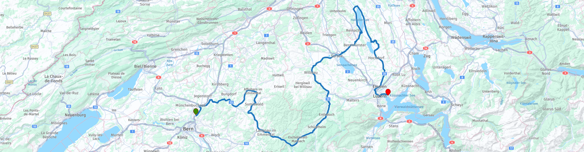
Stage 7 of the Grand Tour of Switzerland goes from Bern to Lucerne. The tour goes through Emmental, the cradle of the famous hole-in-the-wall cheese, with a visit to a cheese factory. The Entelbuch Biosphere Reserve offers natural beauty of the purest kind; Virtually no other region of Switzerland can boast so many natural treasures. You pass the Sempachersee, Hallwillersee, Baldeggersee and end at the Vierwaldstättersee in Lucerne. Along the way you will also visit the water castle Schloss Halwyll and Schloss Heidegg. The roads are of excellent quality. This route undoubtedly deserves 5 stars.
 Share this route


Animation

Verdict


Duration
8h 30m

Mode of travel
Car or motorcycle

Distance
182.29 km

Countries

 RouteXpert Review
 The Emmental cheese factory is a wonderful experience with a charming village character. You can experience both traditional cheese making and the modern production of the world-famous Swiss Emmentaler cheese. The best place to start is the old village cheese dairy, where fresh cheese is made every day in a traditional way. Right next to it there is an information center with lots of reading material about agriculture, milk, cheese and cheese production, as well as small souvenirs and gifts. The tour continues to the former cheese factory. Here you will be greeted by the tantalizing smell of fresh bread and delicious baked goods. The route then takes you to the extensively reconstructed Küherstöckli, where cheese was first made over an open fire in 1741. End your tour in the main building and return to the 21st century and see the hardworking cheesemakers at work, before admiring the enormous wheels of Emmentaler cheese in the maturing cellar.
After this tasty stop, you drive back south to Langnau. Succulent meadows, quiet forests, breathtaking views of the peaks of the Bernese Alps or the Jura Mountains - all this can be found in the beautiful hilly landscape.
Langnau is also surprising in terms of culture. Here yodellers and jazz musicians, painters and cartoonists, classical music lovers and rock concert visitors, serious theater enthusiasts and comedy fans, costume groups and fashion professionals meet. A colorful group that provides the cultural diversity that gives Langnau its special charm.
In the café restaurant Pöstli, right opposite the station, you can enjoy coffee, tea and cakes.
Endless peat landscapes, coarse karst gorges, wild mountain streams and lakes provide a special spectacle. Switzerland's first biosphere reserve offers natural beauty of the purest kind; Virtually no other region of Switzerland can boast as many natural treasures as the 'wild west' of Lucerne.
In Entlebuch you can take a lunch break in Restaurant Meienrisli. Traditional and regional specialties are served there. The restaurant stands for conviviality and radiates an original gastronomic tradition. With high-quality products from Entlebuch, they bring their own regional added value to their dishes.
Lake Sempach is located in the heart of Switzerland and is surrounded by beautiful scenery. Unspoiled nature, cultural and historical sights make the Sempachersee region an ideal area to stay. It is located at an altitude of 504 meters. With an area of 14.5 km2, it is the largest lake located entirely in the canton of Lucerne. The lake is about 7.5 kilometers long and just under three kilometers wide. The lake is mainly fed by the Grosse and Kleine Aa, which flow onto the southern bank near Sempach. In the north, in the Seehüseren area, the Suhre flows into the lake.
Not much further you come to the Hawillersee.
The Hallwilersee, like the Baldeggersee slightly further south, is located in a north-south oriented valley that runs from the Lucerne hinterland to Lenzburg. The banks of the Hallwilersee are not allowed to be built on, so a walk along the banks of the lake offers an impressive natural landscape. The fleet of the Hallwilersee shipping company consists of five small, beautiful salon boats.
The surface of the lake is approximately 10.3 km² and the deepest point is 47 meters deep; the lake is at an altitude of 449 m. Directly on the shore are the villages of Beinwil am See, Meisterschwanden and Seengen. In Seengen, on the north side, is the 'water castle' Hallwyl from 1265.
Hallwyl Castle is one of the most beautiful moated castles in Switzerland. The imposing castle complex is located just a few minutes' walk from Lake Hallwiler, extends over three islands and nestles charmingly into the surrounding recreation area. The exhibitions in the 900-year-old castle document the history of its construction and provide insight into the lives of the Hallwyl family who once owned it. The daily lives of the subjects, such as farmers and millers, are also the subject of the exhibition, and the eerie wails of the prisoners can be heard from the dungeon tower. After the visit to the museum, the idyllic castle courtyard with café invites you to linger.
At Baldeggersee you leave the main road to Heidegg Castle. For many centuries this feudal building was home to the Patrician Heidegg family; Today this is the historical-cultural center. In this residential museum you can learn about the history and customs of noble families. Around the castle, an extensive park with vineyard, a romantic sunken road, the wonderfully scented rose garden and a stately chestnut avenue beckons. And finally there is the castle café with coffee and cake.
The tour continues south to Lucerne.
Hidden in an impressive mountain panorama lies Lucerne, the gateway to Central Switzerland, on Lake Lucerne. In addition to various sights, the city also has attractive shops, but is also uniquely situated on the lake and nearby mountains.
The cityscape of Lucerne is characterized by the covered, medieval chapel bridge, which with its painted panels is considered one of the oldest covered wooden bridges in Europe. Another symbol of the city is the medieval city wall, which has been preserved in its original form except for a tower. Historic, frescoed houses line the pedestrianized Old Town's picturesque squares. The Jesuit church from the 17th century is considered the first sacred Baroque building in Switzerland and the two towers of the Hofkirche are an indispensable part of the cityscape. The Reuss River separates historic Lucerne from the new city.
Lake Lucerne is the most varied lake in the country. It is somewhat reminiscent of a fjord landscape, but is characterized by a mild lake climate. Cruises on five historic paddle steamers and 15 elegant salon motorboats are among the highlights of the region. The name of the lake has its origins in the historic four 'Waldstätten', the three original cantons of Uri, Schwyz and Unterwalden and the canton of Lucerne, which together surround Lake Lucerne. In the past, the lake was an important transport axis and until 1863 the only trade route to the Gotthard Pass.
Hotel Seeburg, your final destination after this ride, is located on this beautiful lake. The lake at your feet, the city around the corner, the snow-capped Alps on the horizon - there is no better place in Lucerne to let your gaze wander into the distance.
After this day, enjoy the peace and privacy of a beautiful room. In green or blue - forest or lake - the choice is yours. Each of the renovated rooms also has a balcony.
You will be spoiled with seasonal culinary delights and first-class drinks all year round in the Seeburg Restaurant and in the Sunset Bar right on the lake. There is also private parking.


 Links
Links  Usage
Usage Want to download this route?
You can download the route for free without MyRoute-app account. To do so, open the route and click 'save as'. Want to edit this route?
No problem, start by opening the route. Follow the tutorial and create your personal MyRoute-app account. After registration, your trial starts automatically.  Disclaimer
Use of this GPS route is at your own expense and risk. The route has been carefully composed and checked by a MyRoute-app accredited RouteXpert for use on TomTom, Garmin and MyRoute-app Navigation.
Changes may nevertheless have occurred due to changed circumstances, road diversions or seasonal closures. We therefore recommend checking each route before use.
Preferably use the route track in your navigation system. More information about the use of MyRoute-app can be found on the website under 'Community' or 'Academy'.

Bern
About this region
Bern (German: [bɛrn] (listen); Alemannic German: Bärn [b̥æːrn]) or Berne (French: [bɛʁn] (listen); Arpitan: Bèrna [ˈbɛʁna] (listen); Italian: Berna [ˈbɛrna]; Romansh: Berna [ˈbɛrnɐ] (listen)) is the de facto capital of Switzerland, referred to by the Swiss as their "federal city" (in German: Bundesstadt, French: ville fédérale, and Italian: città federale). With a population of about 144,000 (as of 2020), Bern is the fifth-most populous city in Switzerland. The Bern agglomeration, which includes 36 municipalities, had a population of 406,900 in 2014. The metropolitan area had a population of 660,000 in 2000.Bern is also the capital of the canton of Bern, the second-most populous of Switzerland's cantons. The official language is German, but the main spoken language is the local variant of the Alemannic Swiss German dialect, Bernese German. In 1983, the historic old town (in German: Altstadt) in the centre of Bern became a UNESCO World Heritage Site.
Read more on Wikipedia
View region
 Statistics
  24
24Amount of RX reviews (Bern)
 16435
16435Amount of visitors (Bern)
 1751
1751Amount of downloads (Bern)
 Route Collections in this region
 The 24 Most Beautiful Alpine Routes
The Alps, The Alps are a mountain range in Europe, stretching from the French Mediterranean coast in the southwest to the Pannonian Plain in the east. The area of the mountain range is more than 200,000 km².
In other words Passes and Mountain Roads!
Driving through the mountains is great! Especially over the mountain passes with hairpin bends and narrow winding roads. Every bend a different view where you can enjoy. There are many beautiful mountain passes in the Alps.
A selection that has also been incorporated into these routes:
The Stlevio Pass:
The Stelvio Pass, also known as Passo dello Stelvio, is mainly known for the stage in the Giro d'Italia. Due to the length and the difference in height, this pass is seen as one of the toughest tests in cycling. The Stelvio Pass reaches a maximum height of 2758 meters and is therefore one of the highest in the Alps. The pass connects the towns of Bormio and Prato Allo Stelvio. In winter the pass is closed due to heavy snowfall.
The Reschenpass:
The Reschenpass, also known as Passo di Resia, connects the Austrian state of Tyrol with the Italian province of South Tyrol. The pass reaches a maximum height of 1,504 meters and has been one of the most important north-south connections in the Alps in recent centuries. The pass was used long before Roman times. Along the way you will pass several highlights and historical relics. One of the highlights is the Reschensee. This lake was created after the construction of the dam and has completely submerged the village of Graun. The only thing that reminds of that is the clock tower in the middle of the lake.
Col du Galibier:
The French mountain pass Col du Galibier connects the towns of Saint-Michel-de-Maurienne and Briançon via the Col du Lautaret in the south and the Col du Télégraphe in the north. The mountain pass is part of the Tour de France and very much feared, due to the fact that it can only be reached via the other two mountain passes. The pass reaches a maximum height of 2646 meters. From there you can take a walk to the viewpoint at 2704 meters. You can admire the peaks of the Grand Galibier, Mont Blanc and La Meije here.
The Grossglockner High Alpine Road:
With a height of 3798 meters the Grossglockner is the highest mountain in Austria. To fully enjoy this impressive mountain, you can drive over the Grossglockner High Alpine Road and the accompanying pass. The route starts from Bruck am Grossglockner and ends in Heiligenblut. Of course you can drive in two directions. The pass reaches a maximum height of 2504 meters and is closed in winter due to heavy snowfall. Along the way you pass several stops with fun activities, information points, mountain huts and viewpoints. A visit to the Kaiser-Franz-Josefs-Höhe and Pasterzen Glacier is highly recommended.
The Col d'Izoard:
Just like the Col du Galibier, the Col d'Izoard is also part of a stage of the Tour de France. The mountain pass connects Briançon with the valley of the river Guil. The pass is partly located in the Regional Natural Park du Queyras and reaches a maximum height of 2360 meters. What is special about the Col d'Izoard is the barren and rocky landscape. Sometimes it feels like driving a car over the moon! Along the way you can stop at several points to enjoy the beautiful view.
The Bernina Pass:
The Bernina Express is one of the most famous rail trains in Switzerland and the Alps. The route is beautiful and partly included on the UNESCO World Heritage List. Parallel to the railway lies the Bernina pass, which connects the Veltlin valley with the Egandin valley. This beautiful Alpine road has a total length of 56 kilometers and reaches a maximum height of 2328 meters. Along the way you can enjoy views of the Morteratsch Glacier.
The Sella Pass:
The Sella Pass, also known as Passo di Sella, takes you over one of the most impressive mountain ranges in the Dolomites: the Sella massif. The pass connects Valle di Fassa with Val Gardena and reaches a maximum height of 2236 meters. At this height is also the border of the Italian provinces of Trentino and Bolzano. Along the way you can enjoy the view of this spectacular mountain world. Admire, for example, the three peaks of the Sasso Lungo massif, the Sella massif or the peaks of the Marmolada. You can also drive the Sella pass in combination with the Gardena pass, Pordoi pass and Campolongo pass.
The Grimsel Pass:
The Grimsel Pass connects Goms in Wallis with the Halis Valley in the Bernese Oberland. The pass reaches a maximum elevation of 2165 meters and is closed in winter due to snowfall. Over the centuries, the mountain pass has played an important role in trade between Switzerland and Italy. Now it is mainly the reservoirs that have an important function. These are used to generate electricity. The landscape you drive through is rugged, rocky and impressive. On top of the pass is a hotel and a restaurant with a special marmot park. The Dodensee (Totensee) is also located here. This lake owes its name to the many soldiers who died in the time of Napoleon.
The Gotthard Pass:
The Gotthard Pass, also known as Passo del San Gottardo and Saint Gotthard, connects the Swiss towns of Airolo and Andermatt. The mountain pass and associated tunnel are especially known among holidaymakers driving from Switzerland to Italy. But where the majority opt for the tunnel, it is precisely the pass that really completes the holiday. The Gotthard Pass has a length of about 26 kilometers and reaches a maximum height of 2106 meters. The route is beautiful and takes you along old villages and beautiful views.
The Silvretta High Alpine Road and Silvretta Pass:
The Paznaun Valley in Tyrol and the Montafon in Vorarlberg are connected by the Silvretta High Alpine Road. The route has a length of 22.3 kilometers and leads from Galtür to Partenen in 34 hairpin bends, via the 2032 meter high Bielerhöhe. The Silvrettasee is also located at this point, where you can enjoy a lovely walk. The pass is closed in winter due to snowfall.
The Simplon Pass:
Just like the Gotthard Pass, many holidaymakers also travel over the Simplon Pass every year. This mountain pass connects the Rhone Valley in the canton of Valais with the Valle d'Ossola in Piemonte. The pass is open all year round and reaches a maximum height of 2005 meters. Along the way you pass a number of buildings, including the well-known Simplon Hospiz from 1825. The hospiz is managed by the monks of St. Bernard. From the highest point on the pass, all kinds of hiking routes are possible and you will also come across a hotel where you can spend the night.
The Gerlos Pass:
The Gerlos Pass connects the Salzach Valley in the Salzburgerland with the Zillertal Valley in Tyrol. The pass is part of the Gerlos Alpenstraße and runs right through the Hohe Tauern National Park. Along the way you can enjoy beautiful views of the surroundings. The pass has a length of 12 kilometers and reaches a maximum height of 1531 meters. A ride over the Gerlos Pass can be ideally combined with a visit to the Krimmler Wasserfälle.
The Great St. Bernard Pass:
The Great St. Bernard Pass, better known as Col du Grand Saint Bernard, connects the Italian province of Valle d'Aosta with the Swiss canton of Valais. The pass is one of the highest in Switzerland and reaches a maximum height of 2469 meters. Like a number of other mountain passes in this list, the Great St. Bernard Pass has also been used as a connecting road for centuries. The pass is named after the St. Bernard dogs that used to help stranded travelers along with the monks. The pass is closed in winter.
The Timmelsjoch High Alpine Road:
The Timmelsjoch High Alpine Road connects the towns of Sölden in the Ötztal and Meran in South Tyrol. Tolls must be paid on the Hochgurgl - Moos route. Via a mountain road with about 60 hairpin bends you drive through a beautiful mountain world. With the Timmelsjoch Experience you can learn more about the history, the road and the environment via various stations. You can also visit the Top Mountain Crosspoint museum.
Col de l'Iseran:
With a maximum pass height of 2770 meters, the Col l'Iséran is one of the highest mountain passes in the Alps. The pass connects Bourg-Saint-Maurice with Bonneval-sur-Arc. Via a road full of hairpin bends you pass, among other things, Val-d'Isère and a side valley of the Maurienne that lies entirely in the National Park de la Vanoise. You can spot animals such as marmots and chamois and there is also a restaurant with a chapel on top of the pass.
The Gavia Pass:
The Gavia Pass (Italian Passo di Gavia) is a mountain pass in the Italian Alps, in the Lombardy region.
It is one of the highest pass roads in Europe. The road leads through the unspoilt Stelvio National Park. The road was built in the First World War to supply Italian soldiers who fought in the Italian-Austrian border area. The pass height is one of the most beautiful in the Alps. Here is the large Lago Bianco with, to the north, the mountain San Matteo (3684 meters). Lago Nero is slightly lower on the south side of the pass. Here the mountain group of the Adamello determines the view. There are many well-marked walks in the area. During the winter the pass is closed due to the heavy snowfall. The pass is often closed until May and June due to the large amount of snow.
Promoter has made a selection of the 24 Most Beautiful Alpine routes that they have set out in recent years.
The routes go through:
France
Austria
Switzerland
Italy
The most beautiful roads, the most beautiful views, the most beautiful viewpoints. The highest mountains, the fastest descents, hairpin bend after hairpin bend, you name it you can't get enough of it.
If you go on holiday in this region, take advantage of it, ALL routes in this collection have been checked and made equal for TomTom, Garmin and MyRoute-app Navigation by a MyRoute-app RouteXpert.
Have fun with this collection and while driving one of these routes. Enjoy all the beauty that the Alps and the Dolomites have to offer. Click on “View route” to read the review of the chosen route.
I would like to hear your findings about the route(s).
View Route Collection
11 day trip from the Netherlands
8 countries in 11 days; The Netherlands, Germany, Austria, Italy, Switzerland, France, Luxembourg and Belgium. This route collections consists of 10 routes that I have driven with friends in the summer of 2019.
The start is in Geldermalsen Netherlands, the first 7 days you drive through the Netherlands, Germany, Austria, Italy, Switzerland, France and a piece of Luxembourg with overnight stays in hotels.
The last three days you stay in Barweiler (D) in the Eifel and you drive two beautiful tours through the Eifel, Luxembourg and parts of the Belgian Ardennes.
There is no highway in the routes, only beautiful provincial and country roads, many beautiful passes with beautiful panoramas.
Be sure to check whether the passes are open before you leave.
These are routes for experienced drivers.
View Route Collection