R03 Lokken to Hauge

This route was brought to you by:
RouteXpert Arno van Lochem - Senior RX
Last edit: 01-08-2024
 Route Summary
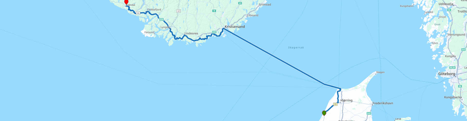
 This route starts in Løkken, just below Hirtshals in the north of Denmark. In Hirtshals you ride the ferry (Fjordline) which will take you to Kristiansand in Norway. Don't gamble on a free spot, but reserve in time!
The end point of this route is at Bakkaåno Camping & Gjestegård in Hauge. A small campsite where you can pitch a tent or rent a cabin.
Sights along the way such as Lindesnes Fyr and Helleren.
The routes are easy for everyone and are (largely) on well-paved roads.
Given the excellent condition of the roads, the beautiful views and the great mountain and rocky surroundings, I rate this route 5 stars.
During the booking process on the Fjordline site, it is best to set the language to Norwegian and have the browser translate into Dutch. You then pay in Norwegian Krone, which can easily save you a few tens of euros for a return trip for one person with a motorcycle compared to the price in Euros. Worth the effort!
 Share this route


Animation

Verdict


Duration
9h 40m

Mode of travel
Car or motorcycle

Distance
352.90 km

Countries


 RouteXpert Review
 In the third part of this 13-piece collection you drive off the boat in Kristiansand and make your first meters in Norway. You will find that Norway is very pleasant to drive.
From the starting point, Bikers Rest in Løkken, you drive in more than half an hour to Hirtshals, where the ferry to Kristiansand is waiting for you. After checking in you will most likely notice that you are not the only one traveling to Norway, which shows that Norway is becoming increasingly popular
Once on the boat you have to secure the engine yourself, there is not always assisting staff present. All in all, it's not too bad and the motorcycle can be secured fairly quickly with the supplied tension straps. Then quickly go upstairs to find a place where you will spend the journey. There is everything you need on board, several restaurants, a bar, shops, you name it.
In Kristiansand you can get off the boat fairly quickly, so that you can continue your journey in Norway. Once you have passed customs and left the port area, you immediately notice that Norway is very different from the north of Denmark where you boarded a few hours ago. Hills, rock formations, Norway has it and gives you a taste of all the beauty to come! That promises something for the coming days, but get your chest wet!
You will soon leave Kristiansand in a westerly direction. In Norway there are so-called fylker, which are roughly comparable to provinces as we know them in the Netherlands. You are now in the fylke Agder. Agder is the southernmost province of Norway. The province was created on January 1, 2020 as a result of the administrative reorganization of the country. The provinces of Aust-Agder and Vest-Agder merged into one fylke. Agder borders Rogaland in the west, Vestfold og Telemark in the east. During the route you cross the border with Rogaland.
The capital of the province is Kristiansand. The province has more than 300,000 inhabitants (2020 level). In a sense, the merger of Aust and Vest-Agder has restored the situation before 1700, when the then Kristiansand amt was split into Nedenes amt (Aust-Agder) and Lister og Mandals amt (Vest-Agder).
While meandering through and getting used to the Norwegian landscape, passing two rivers, among other things, just after the town of Mandal you reach the place where you can enjoy lunch on a beautiful terrace from which you have a wonderful view over a lake with mountains behind it. . So enjoy your lunch extra!
About 30 kilometers further you arrive in the town of Spangereid. There you can decide to take a look at Lindesnes Fyr. Lindesnes fyr (Norwegian for 'Lindesnes lighthouse') is a coastal lighthouse at the southernmost tip of Norway, about 10 kilometers southwest of the village of Spangereid in Lindesnes municipality.
The lighthouse was first built in 1656, to provide access from the North Sea to the Skagerrak and the Baltic Sea. Over the centuries, a new lighthouse was built or rebuilt several times to replace the older one. In 1822 the lighthouse received a coal lamp, in 1854 a new lamp was installed with the current lens. The current tower was built in 1915. Five years later it received its first fog signal in the form of a siren. The fog signal and associated machinery were placed in a building next to the tower.
During the Second World War the lighthouse was captured by the Germans. As an important lookout post they built a small fort with four cannons and after a while a radar antenna. Traces of the war, such as trenches and tunnels, are still visible.
To visit Lindesnes Fyr, do not turn right in the town of Spangereid, but drive straight ahead and follow the directions. Please note, the extra distance is approximately 25 km round trip, keep in mind that a visit takes about 1 to 1.5 hours. However, it is definitely worth it, for more information see the links at the bottom of this page.
The route runs along the E39 for a while, in order to be able to cover some distance in a reasonable time. For example, on the E39 you cross the Fedafjordenbru. The Fedafjord Bridge spans the Fedafjord near the village of Feda, about 70 kilometers west of Kristiansand. The suspension bridge has a length of 566 meters and a main span of 331 meters. The bridge deck is located 50 meters above the fjord. The E39 runs over the bridge with 1x2 lanes. From the bridge there is a good view over the fjord, although it is not as spectacular as the fjords further north.
The Fedafjord Bridge was constructed as part of the Listerpaken, a road project in Vest-Agder that had to cut off a section of the E39, which previously ran via Kvinesund, much further inland. As part of the project, the 3,340-meter-long Ravnehei Tunnels and the Fedafjord Bridge were constructed. The project shortened the travel time between Kristiansand and Stavanger by 20 minutes. The bridge opened to traffic simultaneously with seven short tunnels on August 30, 2006. The entire project cost NOK 1,624 million.
Further along the route, near the village of Sletta, you enter fylke Rogaland. Rogaland is a province of Norway bordering Vestland, Vestfold og Telemark and Agder. Rogaland covers 9325 km² and has 479,892 inhabitants (2010). The province is located on the southwest coast, with inlets and islands. The main island is Karmøy. Boknafjorden is the largest bay.
The road you have been driving on for a while, the Fv44, is a beautifully winding road through an even more beautiful landscape. Every now and then you pass beautiful lakes, where you really should stop for a photo. Once you enter Rogaland, the Fv44 turns into the Åna-Sira Veien and leads you to the Jøssingfjord. This is a fjord in the municipality of Sokndal. The 3 kilometer long fjord is narrow and deep and surrounded by mountains. It is located about 4 kilometers southeast of the municipal center of Hauge, today's final destination.
But before you get there you will pass Helleren. Under a large rock overhang (the meaning of "sloping" is overhanging rock) at the end of the Jøssingfjord are 2 houses from the early 19th century. Three families once lived there, living by herding sheep and fishing. The houses were abandoned around 1920, but they are well preserved, partly due to the protection of the enormous rock.
You can enter the houses, even on a rainy day the houses are completely dry. The rock overhangs so far that the outside of the houses are also kept dry and therefore well preserved, and a good roof is not really necessary, the rock protects everything. Very nice to take a closer look.
More than 5 kilometers further you reach Hauge. If you need to do some shopping or refuel, do not turn right on the route, but drive straight into the village. You will find two supermarkets there, as well as two gas stations.
After shopping, pick up the route where you left it and drive to the final destination of this route, Bakkaåno Camping & Gjestegård. A quiet campsite with a number of cabins for rent, as well as a number of pitches for tents, caravans or campers.
Have fun driving this route!


 Links
Links  Usage
Usage Want to download this route?
You can download the route for free without MyRoute-app account. To do so, open the route and click 'save as'. Want to edit this route?
No problem, start by opening the route. Follow the tutorial and create your personal MyRoute-app account. After registration, your trial starts automatically.  Disclaimer
Use of this GPS route is at your own expense and risk. The route has been carefully composed and checked by a MyRoute-app accredited RouteXpert for use on TomTom, Garmin and MyRoute-app Navigation.
Changes may nevertheless have occurred due to changed circumstances, road diversions or seasonal closures. We therefore recommend checking each route before use.
Preferably use the route track in your navigation system. More information about the use of MyRoute-app can be found on the website under 'Community' or 'Academy'.

Noord Jutland
About this region
The North European Plain (German: Norddeutsches Tiefland – North German Plain; Mitteleuropäische Tiefebene; Polish: Nizina Środkowoeuropejska – Central European Plain; Danish: Nordeuropæiske Lavland and Dutch: Noord-Europese Laagvlakte ; French : Plaine d'Europe du Nord), is a geomorphological region in Europe, mostly in Poland, Denmark, Germany, Belgium, the Netherlands (Low Countries), with small parts of northern France and the Czech Republic.
It consists of the low plains between the Hercynian Europe (Central European Highlands) to the south and coastlines of the North Sea and the Baltic Sea to the north. These two seas are separated by the Jutland Peninsula (Denmark). The North European Plain is connected to the East European Plain, together forming the majority of the Great European Plain (European Plain).
Read more on Wikipedia
It consists of the low plains between the Hercynian Europe (Central European Highlands) to the south and coastlines of the North Sea and the Baltic Sea to the north. These two seas are separated by the Jutland Peninsula (Denmark). The North European Plain is connected to the East European Plain, together forming the majority of the Great European Plain (European Plain).
View region
 Statistics
  9
9Amount of RX reviews (Noord Jutland)
 370
370Amount of visitors (Noord Jutland)
 142
142Amount of downloads (Noord Jutland)
 Route Collections in this region
 four-day tour through northern Jutland Denmark
Jutland is not known as a cornering paradise for motorcyclists, but is mainly known for its culture and nature. Especially peace, space, beautiful beaches and nice towns and villages make this area a favorite with the Danes themselves.
The routes include various highlights as well as various cultural objects such as museums, castles, lighthouses, etc. If you are going to drive this route, it is best to determine in advance what you do and do not want to visit. The entire program is always more than a day filling.
In 4 days and more than 950 kilometers you can explore the whole of Jutland. Don't forget to check the ferry times and opening times of any museums and attractions you want to visit in advance.
Have fun in Denmark and keep your fingers crossed for good weather.
View Route Collection
13 day roundtrip South Norway
A 13-part motorcycle journey through southern Norway is like a letter to nature, where every bend and every horizon reveals a new chapter. This journey is characterized by the smell of pine forests and the sound of cascading waterfalls, while your engine rumbles softly on the winding roads that take you deeper into the Norwegian wilderness.
A highlight of this trip is Dalsnibba, where you ride above the clouds and are greeted by panoramic views of deep fjords and snow-capped mountains. It feels like the world stands still for a moment as you admire the majestic beauty of the Geirangerfjord below you.
From there, the road takes you to Geiranger, an enchanting village nestled by the fjord of the same name. As you drive along the fjord, the waterfalls – such as the famous “Seven Sisters” – seem to perform a dance. Here you feel the grandeur of nature right into your soul.
The next few days will take you along the iconic Trollstigen, the "Troll Road". With its eleven hairpin bends and steep cliffs, it is an adventure in itself. As you reach the peaks, it feels like you are touching the ancient legends of Norway itself. The silence is only broken by the rushing of mountain streams and the hum of your engine.
Another highlight of the trip is the Atlantic Road, a masterpiece of road engineering that winds gracefully over small islands and bridges, as if designed by nature itself. With the Atlantic Ocean on either side, you feel the freedom of the open water, as the sea breeze caresses your face.
Every day is filled with contrasts: deep fjords and high mountain passes, serene lakes and wild coastlines. Norwegian culture – from picturesque villages to charming mountain huts – invites you to stop and enjoy heart-warming food and friendly encounters.
This journey is not just a ride; it is an ode to adventure, connection and the pure beauty of the world. You will return not only with unforgettable memories, but also with a heart that is forever a piece of Norway.
Some of the routes include sections of gravel roads. These roads are of such a quality that they are easy to drive for everyone. Gravel roads and cabins are an integral part of the real Norwegian adventure. They offer a unique opportunity to explore the country in an authentic, intimate way, away from the hustle and bustle of paved main roads and standard tourist accommodations.
Using gravel roads and staying in cabins offers a perfect balance between adventure and relaxation. During the day you explore rugged, remote areas where asphalt ends and nature begins. In the evening you relax in a cozy cabin, where the simplicity of life and the beauty of Norway come together.
Of course, you are also free to pitch your own tent at the campsites where the routes end.
This combination makes a holiday in Norway an unforgettable experience, where you get to know the real soul of the country. It is a way to get closer to nature, challenge yourself and at the same time have a warm refuge to recharge for the next day of discoveries.
The routes of this collection:
R01 A1 De Poppe to Schleswig, 392km
R02 Schleswig to Lokken, 378km
R03 Lokken to Hauge, 353km
R04 Hauge to Odda, 340km
R05 Odda to Skjolden, 344km
R06 Skjolden to Molde, 315km
R07 Molde to Innbygda, 343km
R08 Innbygda to Atna, 295km
R09 Atna to Nesbyen, 330km
R10 Nesbyen to Seljord, 301km
R11 Seljord to Lokken, 385km
R12 Lokken to Schleswig, 398km
R13 Schleswig to A1 De Poppe, 407km
Have fun riding these routes!
View Route Collection