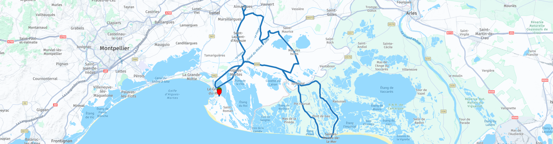
Le Grau du Roi Camargue Roundtour

This route was brought to you by:
RouteXpert Aendu (Andreas) Lenz
Last edit: 24-03-2025
 Route Summary
 Highlights:
- Tour Carbonnière (with a wide view)
- Aigues-Mortes (city walls, town and typical French market)
- River crossing by ferry
- saltworks
Vehicle/Driver: Motorcycle, relaxed driving, also suitable for beginners.
On this route you can visit:
- Aigues-Mortes
- Saline salt plant (near Aigues-Mortes)
- Saintes Maries de la Mer (church)
This route deserves a star rating of 3-4:
Most roads have little traffic, beautiful views, places worth seeing, wonderful landscapes and buildings.
 Share this route


Animation

Verdict


Duration
8h 20m

Mode of travel
Car or motorcycle

Distance
113.66 km

Countries

 RouteXpert Review
 Info for motorcyclists:
If you are travelling by motorbike you can park directly in front of the places/buildings worth seeing. If you are travelling by car you often have to park a little further away.
-This route starts and ends in "Le Grau du Roi". I chose this start and end point for the following reason: The start and end point can be reached without traffic delays. A more central point could mean that the journey could take more time. There is a petrol station here with a small shop (petrol and drinks)
We start here and after a short drive we reach the:
"Tour Carbonnière"
The tower is open 24 hours a day and offers a great panoramic view. Climb the spiral staircase and enjoy the view. From here you have a perfect view over the swamps. The birds that live here can be observed very well.
"Canal du Rhône à Sète"
The "Canal du Rhône à Sète" is used for leisure boat trips, small boats and tourist boats and allows certain clubs to practice rowing. In various places it is possible to rent houseboats, these travel very slowly. A speed of only 6 km/h is permitted. Ideal for hobby captains. When renting the houseboat there is an introduction and you can get started right away.
Story:
In 1773, it was decided to build a canal between Beaucaire and Aiges-Mortes. In 1789, construction was interrupted. The canal between Aigues-Mortes and Saint-Gilles had already been completed. In 1801, construction of the rest of the canal began. The canal was completed in 1808. Locks were built in between so that ships could maneuver better. These locks were built near the Rhône to prevent the canals from silting up and the buildings near the canal from being flooded.
Story:
This stone tower was built in the 13th century. Anyone who wanted to go to Aigues-Mortes from the mainland had to pass through this place and pay a toll. At first, academics could pass for free. Later, however, everyone had to pay a toll.
-The journey continues towards "Aimargues". We drive through the village and under a railway underpass that is only 1.7 metres high. Be careful, duck your head. You could also skip this point and drive straight after "Le Cailar" on the D104 road. There is a water tower on the left, and shortly after that we turn right into a car park. On the small hill we have a view of the swamp. Unfortunately the trees have grown tall and block the view of the swamp somewhat. After a short drive we come to a bridge that crosses the "Canal du Rhône a Sète".
Unfortunately, this is a dead end, so we turn around and turn right shortly afterwards. We continue between the Etanges on a straight and slightly bumpy road. We enjoy the view of nature and animals on this road with little traffic. Now we set off for:
“Saintes-Maries-de-la-Mer”
In the region around "Saintes-Maries-de-la-Mer" (Camargue) there are many riding stables with the famous "white horses". The horses are a great way to explore and observe the area. Since horses and cowboys belong together, there is also a shop in "Saintes-Maries-de-la-Mer" that sells cowboy boots, among other things.
Story:
In 542, the village was transferred to a monastery (by Césaire of Arles). In the 14th century, the church was rebuilt. The "Notre-Dame-de-la-Mer" now became a fortified church. Before that, raids by the Vikings and "Saracens" started from "Saint-Maries-de-la-Mer", including to "Arles". During the French Revolution, the church was partially destroyed but restored in 1873.
-We continue to Bac de Sauvage D38/D85 on the ferry, free ferry which is only open seasonally. (Check the timetable). Then we continue towards:
"Aigues-Mortes"
The main entrance is on the north side at parking lot 1. You can park your motorcycle for free on the sidewalk right next to the entrance.
On Wednesday and Saturday there is a market a few streets away. The market starts at 8am and lasts until around 1pm. As is usual in France, in addition to regional vegetables, fruit, cheese (meat, fish), there are also clothes and household items to buy at this market. Chat to the market traders and you will get a tip or two from them. If you visit "Aigues-Mortes" on Saturday, get there early (9am), the later you arrive, the more difficult it will be to find a parking space. (This applies especially to cars)
Story:
“Aigues-Mortes” was built in the 13th century and was located on a lagoon. The city was connected to the sea by canals. The only connection to the mainland was the “Tour Carbonnière”. The many moors separated “Aigues-Mortes” from the mainland.
-Before we reach the end of this excursion, we will drive past the saltworks of “Aigues-Mortes”. Anyone who still has time and desire can visit this saltworks.
Saline (salt production plant)
Salt is extracted by evaporating sea water. You can take a tour of the facility (for example on the little train). If you visit the saltworks, allow at least 2 hours. There is also a museum. (And no wonder) the saltworks were also built in the 13th century.
-The exit ends in “Le Grau du Roi”


 Links
Links  Usage
Usage Want to download this route?
You can download the route for free without MyRoute-app account. To do so, open the route and click 'save as'. Want to edit this route?
No problem, start by opening the route. Follow the tutorial and create your personal MyRoute-app account. After registration, your trial starts automatically.  Disclaimer
Use of this GPS route is at your own expense and risk. The route has been carefully composed and checked by a MyRoute-app accredited RouteXpert for use on TomTom, Garmin and MyRoute-app Navigation.
Changes may nevertheless have occurred due to changed circumstances, road diversions or seasonal closures. We therefore recommend checking each route before use.
Preferably use the route track in your navigation system. More information about the use of MyRoute-app can be found on the website under 'Community' or 'Academy'.

Occitanie
About this region
Occitanie (French pronunciation: [ɔksitani] (listen); Occitan: Occitània [utsiˈtanjɔ]; Catalan: Occitània [uksiˈtaniə]), Occitany or Occitania (), is the southernmost administrative region of metropolitan France excluding Corsica, created on 1 January 2016 from the former regions of Languedoc-Roussillon and Midi-Pyrénées. The Council of State approved Occitanie as the new name of the region on 28 September 2016, coming into effect on 30 September 2016.The modern administrative region is named after the larger cultural and historical region of Occitania, which corresponds with the southern third of France. The region Occitanie as it is today covers a territory similar to that ruled by the Counts of Toulouse in the 12th and 13th centuries. The banner of arms of the Counts of Toulouse, known colloquially as the Occitan cross, is used by the modern region and is also a popular cultural symbol. In 2015, Occitanie had a population of 5,839,867.
Read more on Wikipedia
View region
 Statistics
  71
71Amount of RX reviews (Occitanie)
 25853
25853Amount of visitors (Occitanie)
 3625
3625Amount of downloads (Occitanie)
 Route Collections in this region
 25 Magnificent trails in France
This MRA route collection contains 25 beautiful motorcycle routes in different parts of France, such as the Ardennes, the Alsace, Vercors, the Drôme, the Ardèche, Cote d'Azure, Gorges du Verdon, the Ariège, the Dordogne and Brittany.
The routes have been carefully created by Bert Loorbach, who is an enthusiastic motorcyclist himself. He lived in France for a year and a half, during which time he devoted himself to mapping the unknown and beautiful back roads of France especially for motorcyclists.
The routes are bundled in the Motortourgids France part 1 of Kosmos publishing house and now also available in MyRouteApp.
I have taken over the routes in MRA and sometimes adjusted them slightly to make them even more interesting for the motorcyclist.
View Route Collection
24 Magnificent trails in France
It is clear that France is one of the most beautiful and best touring countries. It offers an incredibly varied landscape with good roads and a pleasant climate. It is not for nothing that you see so many motorcyclists there. My previous collection of 25 routes in France (25 Magnificent routes in France) were based on the route descriptions from the Motortourgids France part 1 made by Bert Loorbach.
This collection of 24 routes comes from Motortourgids France part 2. In this collection, a difference has been made between approach routes and motorcycle tours in a certain area. The approach routes can also be used in combination with the routes from Motortourgids France part 1
The routes are sometimes slightly adjusted based on the tips that Bert Loorbach gives in his description, or because of another place to spend the night, or to reach the minimum length of 2 hours for the MRA Library. For each route, the review contains a more detailed description, including options to stay overnight or places of interest along the way, which are also indicated with a POI and if possible with a short description.
Two or more routes have been created for a number of areas, such as for Burgundy, Auvergne, The Alps, Tarn and Cévennes and Nord-Pas de Calais. These routes can be nicely combined in a multi-day trip.
View Route Collection