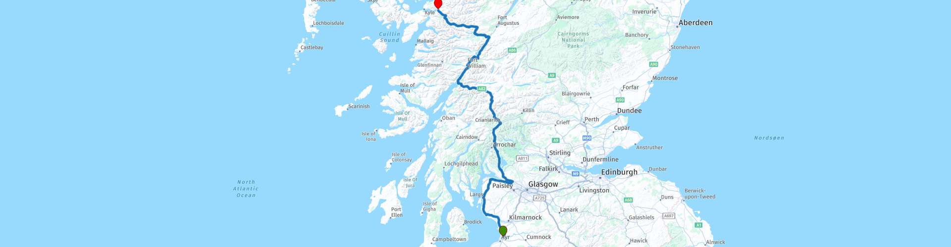
05 Prestwick to Dornie and into The Highlands of Scotland

This route was brought to you by:
RouteXpert Nick Carthew - (MRA Master)
Last edit: 11-11-2021
 Route Summary
 This route enters the Highlands of Scotland and visits: Loch Lomond and Trossachs National Park, the famous Green Welly motorcycle stop for lunch, Rannoch Moor and Glencoe with the opportunity to visit the location for Skyfall, the 007 movie filmed at Glen Etive. The Commando Memorial at Spean Bridge then ends at another 007 Bond film location, Eilean Donan Castle at Dornie.
There is a 14 mile section of single track road from Largs to Greenock this is a great scenic route through the Clyde Muirshiel Regional Park, a little bumpy in places but worth it. You can avoid this by staying on the A78.
The incredibly beautiful landscape and great attractions make this another 5***** route.
 Share this route


Animation

Verdict


Duration
8h 31m

Mode of travel
Car or motorcycle

Distance
349.91 km

Countries

 RouteXpert Review
 Largs is also where this route leaves the A78 to travel through the Clyde Muirshiel Regional Park on a single track road for 14 miles. Clyde Muirshiel is Scotland's largest regional park and covers an area of 108 square miles. The wilderness and beauty of the park's landscape is breathtaking and offers a little taster of what's to come.
Dropping down from the park gives you views of the historic industrial town of Greenock. The town grew from a fishing community to become the site of the first dock on the Clyde in 1711. Greenock flourished as many trade ships from the Caribbean came to the port bearing sugar. Records show that by the year 1850 there were some 400 sugar ships docking at Greenock. For ease of parking, I have suggested a coffee stop at McDonald's on land that was once the heart of Greenock docks.
A short ride from here will see you crossing the River Clyde on the Erskine Bridge and a further 15 minutes sees you on the "bonny bonny banks of Loch Lomond" (well known Scottish song).
Loch Lomond is the largest lake in Great Britain by surface area and it's southern tip marks the invisible border of the Scottish Highlands. At just over 22.5 miles long, you'll have plenty of time to take in the Loch's natural beauty. Loch Lomond is also the southern gateway to the Loch Lomond and Trossachs National Park, the first national park in Scotland. The national park contains a diverse geography that includes 21 munros (Scottish mountains over 3000 feet), two forest parks, 22 lochs, and over 50 designated special nature conservation sites that are home to a variety of wildlife.
Tyndrum, a remote hamlet marks the northern gateway of the national park and it is where you'll find the famous motorcycle meeting place, The Green Welly Stop. At the height of the season, thousands of bikes pass through this point and almost all of them will take a break at Tyndrum’s world-famous landmark. What better place is there than this for a lunch stop!
15 minutes after lunch and you'll reach Rannoch Moor, one of the last remaining wildernesses in Europe, the Great Moor of Rannoch is a beautiful landscape virtually untouched by humans. The area is a vast stretch of land composed of blanket bog, lochans, rivers, and rocky outcrops which makes it a very challenging environment which still supports varieties of flora and fauna. A wealth of plants, insect, bird and animal life can be seen here ranging from curlews and grouse to roe and red deer.
For any James Bond 007 fans using this route, you can take the next left after the Glencoe Ski centre to visit Glen Etive. The mystical and breathtakingly beautiful setting for SkyFall. It was here that James Bond's ancestral home Skyfall was blown up. Don’t forget to drive the entire Skyfall road (15 miles) as the vistas constantly change, you eventually reach a dead-end at the picturesque Loch Etive. Be slow and steady on the gravely roads, and you will soon be wondering how the hell 007 got an Aston Martin down there! Sadly the Skyfall house didn’t exist and was created as a film set in Surrey, England.
The unmissable pyramid mountain to your left is Stob Dearg the highest peak of the Buachaille Etive Mòr range at 1021m or 3350ft. This iconic mountain guards the entrance to Glencoe Pass.
The stunningly beautiful Glencoe Pass, is one of Scotland’s best known glens. The mountains shadow the road from both sides, with the enigmatic Aonach Eagach ridge at plus 900m on the right and the Three Sisters, Beinn Fhada, Gearr Aonach and Aonach Dubh proudly sitting opposite. It can’t be helped wanting to stop and admire the wonderful sites of Glencoe, and thankfully there are plenty of parking places along the way.
At the end of the pass is the recognisable Ballachulish Bridge that crosses the narrows between Loch Leven and Loch Linnhe, linking the villages of South Ballachulish and North Ballachulish. The bridge opened in 1975 replacing the Ballachulish ferry. The first vehicle ferries started in 1906 and were simple rowing boats, with two planks balanced across the middle, then in 1912 a motorised single vehicle turntable ferry was introduced. By the 1920s the ferries grew larger, being able to carry 2 cars at a time. They were still however, little more than converted rowing boats. The first 4 car ferry was introduced in 1951 and by the end of the decade there were 3 such ferries operating. The ferry slipways are still visible on both sides.
A coffee stop is next at the picturesque town of Fort William. Fort William has always been popular with tourists and since the filming nearby of the movies Rob Roy, Braveheart and Harry Potter even more people are flocking to the area.
Fort William is also the western end of the Caledonian Canal that stretches 60 miles along the Great Glen from Fort William to Inverness. It was opened in 1822 and engineered by Scottish civil engineer Thomas Telford allowing shipping to travel from west to east and back. This allowed mariners to avoid the long and often hazardous route round the west of Scotland and through the Pentland Firth. The irony was that by the time the canal was finally complete, steam ships could make the passage around Scotland much more easily than the sailing ships in whose era it was designed.
One of the marvels of the canal is the flight of 8 locks known as Neptune's Staircase. This amazing feat of engineering raises the canal by 19m (62ft) over a quarter of a mile of continuous masonry and takes around 90 minutes for a boat to travel up or down the locks. There is parking nearby to allow you a closer look.
This route takes a lesser known but scenic road along the north side of the canal before crossing back to arrive at a memorial that remembers the British commandos.
The Commando Memorial stands some 17ft or 5.2m high, and comprises a group of three bronze commandos dressed in typical World War Two uniforms and equipment including cap comforters, ammunition pouches and weapons. They are looking south towards Ben Nevis. The commandos were established on the instructions of Prime Minister Winston Churchill immediately after the Dunkirk evacuation in June 1940, as a means of striking back against the German armies occupying Europe. They formed an elite force capable of conducting irregular warfare in a range of different environments and went on to serve with distinction across the globe. During the war 1,700 commandos lost their lives, while many others were seriously wounded: and eight men serving with the commandos were awarded the Victoria Cross.
The view from here towards the UK's highest mountain Ben Nevis at 1345m is superb.
There are numerous places to stop for photos along the way but perhaps none more visited than the viewpoint at Loch Garry. Here, a quirk of perspective makes Loch Garry appear like a map of Scotland.
Reaching Loch Duich indicates that the end of this route is just a few miles away. The ride along the shore of this loch is a great way to end a day's ride.
Most famous for its fabulous castle Eilean Donan at the junction of Lochs Long, Doich and Alsh, there is another local legend connected with Loch Duich, this states that three brothers who went fishing at the loch one night became enraptured by three seal-maidens who had thrown off their furs, assumed the likeness of humans, and danced in the moonlight on the sands. The brothers stole their furs, intending to claim the seal-maidens as their wives. The youngest brother, however, moved by the seal-girl’s distress, returned her seal-skin. For his kindness, the girl’s father allowed the youngest brother to visit the maiden every ninth night. As for the other two brothers, the middle brother lost his wife after the seal-maiden he had captured found her stolen fur, while the eldest brother burnt his wife’s fur as a preventative measure, only to burn her accidentally in the process.
Eilean Donan castle is another treat for James Bond 007 fans as this was the castle used as the Scottish base for MI6 in the 1999 movie 'The World is not Enough' starring Pierce Brosnan as Bond.
The end of this epic route is at the Dornie Hotel, just a few hundred metres from the castle. There are several other choices for accomodation nearby and I strongly advise you to book 2 nights to allow you to visit the Isle of Skye, just a few miles from here. There is a roundtrip route of Skye from Dornie in the MyRoute-app RouteXpert Library which I will include a link for below.
Enjoy.


 Links
Links  Usage
Usage Want to download this route?
You can download the route for free without MyRoute-app account. To do so, open the route and click 'save as'. Want to edit this route?
No problem, start by opening the route. Follow the tutorial and create your personal MyRoute-app account. After registration, your trial starts automatically.  Disclaimer
Use of this GPS route is at your own expense and risk. The route has been carefully composed and checked by a MyRoute-app accredited RouteXpert for use on TomTom, Garmin and MyRoute-app Navigation.
Changes may nevertheless have occurred due to changed circumstances, road diversions or seasonal closures. We therefore recommend checking each route before use.
Preferably use the route track in your navigation system. More information about the use of MyRoute-app can be found on the website under 'Community' or 'Academy'.