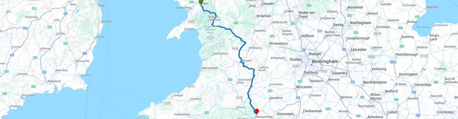
Tregarth to Abergavenny over the Gospel Pass

This route was brought to you by:
RouteXpert Nick Carthew - (MRA Master)
Last edit: 26-04-2021
 Route Summary
  Share this route


Animation

Verdict


Duration
7h 1m

Mode of travel
Car or motorcycle

Distance
251.02 km

Countries

 RouteXpert Review
 I have suggested a coffee stop after just 25 minutes for two reasons: You may have just spent the last hour packing away your camping equipment and might be in need of a cuppa, or, you may want to stop at the delightful cottage that's called (rather inappropriately) The Ugly House! This cottage is full of history, legend and mystery. Nobody knows who built it or when, but there is some knowledge about some of the people who have lived here in the past…
The first person who we know lived here was local shepherd, John Roberts, in 1900. Within the thick dry stone walls his accommodation would have been basic: a single living room with the large fireplace for heat and cooking and a ladder up to a sleeping loft under the roof. The Ugly House, or Ty Hyll in Welsh is owned by the Snowdonia Society and the grounds, beehives and honeybee room are lovingly maintained by volunteers. An alternative coffee stop is just a little further at Betws y Coed.
After Betws y Coed you'll join another stunningly beautiful valley, this one is called the Machno Valley. You can stop and view the Conwy Falls at RP 9 where the River Mancho and Conwy meet and a little further on at RP 10 is an old Roman bridge viewed from the bridge that you're on. The pretty, hideaway village of Penmanch is next with it's robust, stone built cottages and ringed by hills and forests.
Follow the valley and then head up high onto open moorland with 360° views on roads perfectly suited for motorcycles. You can see the road as it twists and turns for miles ahead of you - motorcycle heaven!
You will leave Snowdonia National Park not long after you pass lake Bala, the landscape changes from rugged mountains to more rounded hills. This doesn't mean that the route becomes less dramatic, far from it. You'll enter the Y Berwyn National Nature Reserve, the largest area of heather moorland in Wales. The road is again nice and twisty and with tremendous views all the way to the scheduled lunch stop at New Town. There are a few places to stop for fast food, McDs, KFC and fish and chips are all nearby.
After lunch the route hops over the English border to take in some of the scenery of the Shropshire Hills Area of Outstanding Natural Beauty. This distinctive area of the Anglo-Welsh borders is where remote upland merges into pastoral lowland. The Shropshire Hills is a varied and special landscape which is rich in geology and wildlife with heritage in rolling farmland, woods and river valleys and great to ride through.
Back into Wales and follow close to the border to the market town of Hay on Wye. Nestled on the banks of the River Wye and surrounded by the undulating countryside of the Brecon Beacons National Park, Hay on Wye is a small Welsh town with its identity firmly established in books. I've scheduled a coffee stop here so you can have a quick look around this pretty town.
Leaving Hay on a small road, you will gradually climb to the highest paved road in Wales, the Gospel Pass. This 18-mile lane snakes its way all the way up to the 1,801 feet-high (549m). folklore has it that St Paul came this way taking the bible to Wales. The pass is flanked by the peaks of Hay Bluff (677m) to the east which is also the English border and Waun Fach (811m) to the west. Livestock roam freely so beware. Because of the altitude, the pass is often snow covered in the winter months.
As you come down off the pass you'll see the 900 year old ruins of Llanthony Priory and then the 900 year old Skirrid Inn that's still standing proud serving great ale and hearty meals - a comparison worthy of some thought!
The route ends a short distance from the Inn at a campsite. There is also a campsite at the priory and accomodation at the inn.
I hope you have enjoyed this route and the tour of Wales on 'roads less traveled' that this route belongs to. Enjoy.


 Links
Links  Usage
Usage Want to download this route?
You can download the route for free without MyRoute-app account. To do so, open the route and click 'save as'. Want to edit this route?
No problem, start by opening the route. Follow the tutorial and create your personal MyRoute-app account. After registration, your trial starts automatically.  Disclaimer
Use of this GPS route is at your own expense and risk. The route has been carefully composed and checked by a MyRoute-app accredited RouteXpert for use on TomTom, Garmin and MyRoute-app Navigation.
Changes may nevertheless have occurred due to changed circumstances, road diversions or seasonal closures. We therefore recommend checking each route before use.
Preferably use the route track in your navigation system. More information about the use of MyRoute-app can be found on the website under 'Community' or 'Academy'.


West Midlands
About this region
The West Midlands is a metropolitan county and combined authority area in western-central England with a 2020 estimated population of 2,939,927, making it the second most populous county in England after Greater London. It appeared as a metropolitan county in 1974 after the passage of the Local Government Act 1972, to cover parts of Staffordshire, Worcestershire and Warwickshire. The county is a NUTS 2 region within the wider NUTS 1 region of the same name. It embraces seven metropolitan boroughs: the cities of Birmingham, Coventry and Wolverhampton, and the boroughs of Dudley, Sandwell, Solihull and Walsall.
Read more on Wikipedia
View region
 Statistics
  15
15Amount of RX reviews (West Midlands)
 14908
14908Amount of visitors (West Midlands)
 2121
2121Amount of downloads (West Midlands)
 Route Collections in this region
 5 days through Wales on roads less travelled
As the title suggests, this is a 5 day tour through Wales on 'roads less travelled'. Each daily route has spectacular scenery through sometimes, dramatic landscapes. The tour visits some of Wales' well known sights and some not so well known. It travels across open moorland, deep valleys, the mountains of Snowdonia National Park and the beautiful countryside and coast. You will travel over historic bridges and see historic buildings and sights. This truly is an adventurous tour that I am certain you will enjoy.
View Route Collection
Top 10 Downloaded UK routes by RouteXpert Nick Carthew
Hello and welcome to this collection of the Top 10 MyRoute app downloaded routes in the UK.
There will be a great new event to be announced soon, where all these routes can be ridden.
Download them all now and place them in a new "Top 10" folder, so that you always have them at hand.
If you are going to drive one of these routes in the meantime, track them with the MRA Mobile App or with MRA Navigation. Take some photos (moments) along the way as these will come in handy.
Create a travelstory of your Top 10 driven routes and add the recorded track to it.
There will also be some great prizes on offer, so keep an eye on the MRA-RouteXperts page and your email.
View Route Collection