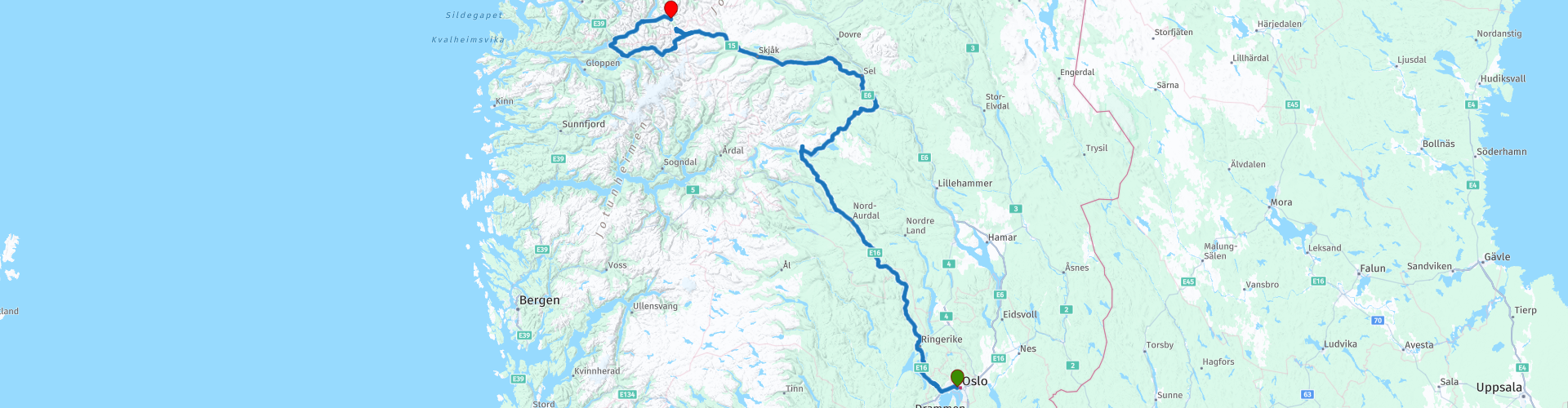
Oslo North Cape day 01 Oslo Geiranger

This route was brought to you by:
RouteXpert Dirk-Jan Berman
Last edit: 26-11-2019
 Route Summary
  Share this route


Animation

Verdict


Duration
7h 5m

Mode of travel
Car or motorcycle

Distance
433.09 km

Countries

 RouteXpert Review
 To spend the night cheaply, it is wise to bring a tent. You can camp anywhere for free, except on land that is private property or in places with a prohibition sign. If you do not want to camp, cabins on campsites are a cheap solution. For safety's sake, however, bring a tent with you.
This route starts in Oslo, where the ferry from Kiel arrives. The end point is in Geiranger, where there are several campsites and hotels to spend the night. To eat and drink along the way, you can bring something yourself. You can also stop at Valdresporten Cafeteria or Grotli Høyfjellshotel for example. There are also options for a coffee break or lunch break at restaurants in the towns of Fagernes, Beitostølen or Lom.
The road to Dalsnibba (the highest European fjord view from the road, 1500 m) is usually open from May to October. The opening times may vary slightly depending on the weather conditions. Toll must be paid on this road. It is also possible to skip this part of the route and continue to the end point.


 Links
Links  Usage
Usage Want to download this route?
You can download the route for free without MyRoute-app account. To do so, open the route and click 'save as'. Want to edit this route?
No problem, start by opening the route. Follow the tutorial and create your personal MyRoute-app account. After registration, your trial starts automatically.  Disclaimer
Use of this GPS route is at your own expense and risk. The route has been carefully composed and checked by a MyRoute-app accredited RouteXpert for use on TomTom, Garmin and MyRoute-app Navigation.
Changes may nevertheless have occurred due to changed circumstances, road diversions or seasonal closures. We therefore recommend checking each route before use.
Preferably use the route track in your navigation system. More information about the use of MyRoute-app can be found on the website under 'Community' or 'Academy'.

Akershus
About this region
Akershus ([ˈɑ̂ːkəʂˌhʉːs] (listen)) is a traditional region and current electoral district in Norway, with Oslo as its main city and traditional capital. It is named after the Akershus Fortress in Oslo. From the middle ages to 1919, Akershus was a fief and main county that included most of Eastern Norway, and from the 17th century until 2020, Akershus also had a more narrow meaning as a (sub) county that included most of the Greater Oslo Region. After 2020 the former county of Akershus was merged into Viken along with the former counties of Østfold and Buskerud. In 2021 the county executive of Viken county initiated the process to dissolve Viken and reestablish Akershus.Originally Akershus was one of four main fiefs in Norway and included almost all of Eastern Norway. The original Akershus became a main county (Stiftamt or Stift) in 1662 and was sometimes also known as Christiania Stift. It included several subcounties (Amt or Underamt); in 1682 its most central areas, consisting of modern Oslo and Akershus, became the subcounty of Akershus within the larger main county of the same name. In 1842 the capital city of Christiania, which at the time consisted of a tiny part of modern Oslo, became a separate subcounty within Akershus main county. The main county of Akershus was disestablished in 1919, and the subcounty continued as Akershus county (fylke). During its history Akershus (sub) county ceded territory to Oslo several times; Akershus' most central and important municipality, Aker, was transferred to Oslo in 1948.
The remaining county of Akershus after 1948 borders Hedmark, Oppland, Buskerud, Oslo, and Østfold; it also has a short border with Sweden (Värmland). Akershus, with a little over 614,000 inhabitants, is the second most populated county by population after Oslo. The county administration is in central Oslo, which is not part of the modern county per se.
Read more on Wikipedia
The remaining county of Akershus after 1948 borders Hedmark, Oppland, Buskerud, Oslo, and Østfold; it also has a short border with Sweden (Värmland). Akershus, with a little over 614,000 inhabitants, is the second most populated county by population after Oslo. The county administration is in central Oslo, which is not part of the modern county per se.
View region
 Statistics
  5
5Amount of RX reviews (Akershus)
 15661
15661Amount of visitors (Akershus)
 463
463Amount of downloads (Akershus)
 Route Collections in this region
 In 12 Days from Oslo to the North Cape
This is a route collection of a motorcycle tour from Oslo to the North Cape, based on a journey by Thomas Falck Østli. A total of twelve routes have been described, but the tour can be extended to more days, more information about this in the reviews.
The routes run through the beautiful landscapes of Norway, including the Lofoten, with many lakes, fjords, rivers, beautiful bridges, beautiful green forests and rugged mountains. During the trip there are also many ferry crossings, keep this in mind in your planning.
You drive longer distances in Norway without encountering a gas station or a restaurant, keep this in mind before you drive. Make sure your tank is full and bring food and drinks. Bring a few bottles of water or Camel bag and fill it up when you stop to refuel. Along the way, breaks are planned for refueling, eating and drinking.
The total trip of almost 3700 kilometers is broken down as follows;
• Day 1 is a 434 kilometer drive from Oslo to Geiranger
• Day 2 is a 238 kilometer drive from Geiranger to Kristiansund
• Day 3 is a 298 kilometer drive from Kristiansund via Trondheim to Verdal
• Day 4 is a 333 kilometer drive from Verdal to Brønnøysund
• Day 5 is a 267 kilometer drive from Brønnøysund to Furøy
• Day 6 is a 296 kilometer drive from Furøy Lofoten to Reine
• Day 7 is a 218 kilometer drive from Reine to Ørsvågvær
• Day 8 is a 274 kilometer drive from Ørsvågvær to Straumsjøen
• Day 9 is a 327 kilometer drive from Straumsjøen to Senjahopen
• Day 10 is a 321 kilometer drive from Senjahopen to Tromsø
• Day 11 is a 420 kilometer drive from Tromsø to Alta
• Day 12 is a 239 km drive from Alta via the North Cape to Skarsvåg
You have the choice to stay overnight at campsites or in hotels. Hotel prices in Norway are not particularly high and breakfast is usually included.
Camping is free almost everywhere, except on private property or where camping is prohibited, indicated by prohibition signs.
If you don't want to camp, there are often cabins for rent on the campsites. For a trip through Norway it is always advisable to bring a tent and other camping gear.
Information about hotels and campsites is included in the directions
Have fun reading, planning and driving this scenic journey to the northernmost tip of Europe.
View Route Collection
6500 kilometers through Scandinavia with the highlights of the Lofoten and the North Cape
The Arctic Challenge Tour, on which this 26-part tour is partly based, is not a speed race. It's a tour. It comes down to agility, good navigation and anticipation. The participants are obliged to adhere to the speed limit of the country concerned. The participants must find the ideal route with the shortest possible distance by complying 100% with the locally applicable traffic rules. Of course, also take maximum speeds into account. The organization checks for violations of the speed limit. In case of gross or repeated exceeding of the maximum speed, disqualification for the relevant stage and for the final classification will follow. Control of the route and speeds is done by means of a track and trace system. This equipment is installed in every vehicle. You can then follow each team accurately in the Back Office. Those staying at home, interested parties and participants can also see the performances of the teams, because you can be followed live via the Internet. The Back Office takes action when a team gets into trouble. (source: website The Arctic Challenge)
That's quite a luxury, having a back office behind you that keeps an eye on you. Most of us will not have that and are on our own or the fellow traveler(s). The only agreement you have with the participants is that you also have to abide by the rules. Fortunately, you don't have to complete this tour in 9 days, like the participants, but you can take it a little longer.
The highlight of the Arctic Challenge in 2020 was the Lofoten, an island group northwest of Norway. The Lofoten archipelago is located in the middle of the wild Norwegian Sea, well above the Arctic Circle. This special region offers a beautiful landscape with imposing mountains, deep fjords and long, wild sandy beaches where the sound of the seabird colonies can always be heard.
The archipelago is best known for its rich fishing tradition. The Lofoten makes a prosperous impression despite their isolated location. The entire economy revolves above all around fishing. The image of the Lofoten is mainly dominated by wooden racks with cod, which hangs to dry. Lofoten fishing has been a household name for centuries. In the middle of winter, the ships set out to catch the fish in just a few months. The rich fishing grounds are due to the North Atlantic Warm Gulf Stream around the islands, in which the fish have their spawning grounds. Oil drilling is not permitted around Lofoten and the cod spawning grounds there.
The next destination for the participants was Sirkka, also known as Levi, a winter sports resort in Finnish Lapland. They stayed there for a few days to go ice-karting and to enjoy the snow by going on a snowmobile or skiing trip. This tour also takes you to Sirkka, but instead of staying there for a few days, you have the option to continue to the North Cape, the second highlight of this trip.
Imagine a place in the far north, where the Atlantic Ocean meets the icy waters of the Arctic Ocean. This place is the North Cape in Western Finnmark in Northern Norway. From here, only the archipelago of Spitsbergen lies between you and the North Pole and the sun shines for 2.5 months at a time; from mid-May to the end of July. Many visitors admire the midnight sun or the sunset over the Barents Sea from the North Cape plateau.
With each route you will find a review with a description of the route, where you pass and what to see along the way. It is also briefly described how the participants in the Arctic Challenge in 2020 had to drive it anyway, from which point to which point. Along the way, markings (route points) have been included that indicate the end points of the stages that the participants had to complete. As mentioned, they covered the distance in 9 days, stages of more than 1000 kilometers were no exception.
Each route ends at a hotel. It is of course not an obligation to use these hotels, you can always find another place to stay in the area, that decision is up to you. My experience, however, is that they are all simple but good hotels for a very reasonable price. They are known and can be booked at booking.com.
The routes of these collections:
R01 - Puttgarden to Angelholm, 280km
R02 - Angelholm to Alingsas, 281km
R03 - Alingsas to Mysen, 261km
R04 - Mysen to Rena, 312km
R05 - Rena to Orkanger, 306km
R06 - Orkanger to Grong, 292km
R07 - Grong to Mo i Rana, 290km
R08 - Mo i Rana to Bodo, 231km
R09 - Roundtour Bodo to Lofoten part 1, 314km
R10 - Roundtour Bodo to Lofoten part 2, 250km
R11 - Roundtour Bodo to Lofoten part 3, 291km
R12 - Bodo to Arjeplog, 295km
R13 - Arjeplog to Jokkmokk, 244km
R14 - Jokkmokk to Pajala, 239km
R15 - Roundtour Sirkka to North Cape part 1, 257km
R16 - Roundtour Sirkka to North Cape part 2, 300km
R17 - Roundtour Sirkka to North Cape part 3, 244km
R18 - Roundtour Sirkka to North Cape part 4, 275km
R19 - Roundtour Sirkka to North Cape part 5, 332km
R20 - Sirkka to Kemi, 299km
R21 - Kemi to Ylivieska, 251km
R22 - Ylivieska to Jalasjarvi, 236km
R23 - Jalasjarvi to Turku, 279km
R24 - Stockholm to Askersund, 271km
R25 - Askersund to Varnamo, 224
R26 - Varnamo to Trelleborg, 259km
Have fun driving these routes!
View Route Collection