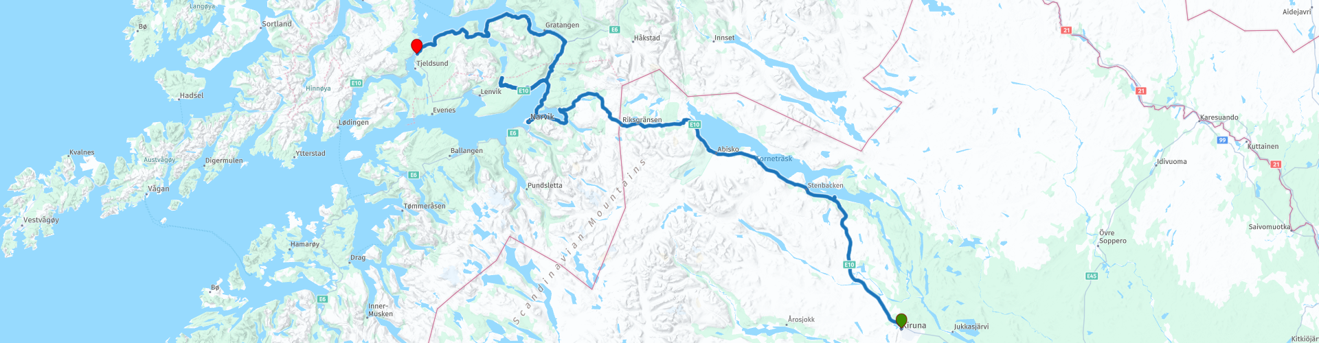
07 Kiruna to Evenskjer

This route was brought to you by:
RouteXpert Leon Bodegom
Last edit: 22-10-2023
 Route Summary
 On this part of the route you leave Sweden to reach the Lofoten Islands via mainland Norway.
Quiet roads and bends alternate with many forests and green hills. Here in the north the chance of spotting moose right along the road is very high. Take the warning about crossing wildlife here seriously. The main roads are also fenced to prevent collisions with animals.
I awarded the route 5 stars because the rolling forest landscape and the quiet, vast surroundings make it pleasant to drive. After the last junction in the E10-E45 of the main roads, driving is quieter because North Cape travelers often choose a different route.
The peaceful surroundings and reaching the beginning of the Lofoten is a highlight of the trip.
 Share this route


Animation

Verdict


Duration
8h 10m

Mode of travel
Car or motorcycle

Distance
275.27 km

Countries


 RouteXpert Review
 Here in the northernmost part of the route and leave the forest land behind us. It is mainly the tranquility and natural beauty that make this route beautiful. Here in the far north the number of tourist attractions is limited. Likewise, for refueling and the inner man, you are dependent on only a limited number of stops. These are indicated along the route so that you know when the next opportunity is on route.
Please note, there is no refueling facility at the end of the route, the last refueling stop is 30 KM before arrival in Evenskjer.
After departure, there is another viewpoint north of Kiruna at 726 M above sea level to take a quick look at Kiruna. After this you continue the route to the northwest and drive parallel to the railway line to Narvik again. This line was opened in 1888 and set up for the transport of iron ore from the Swedish interior to Narvik in Norway and Lulea on the Gulf of Bothnia.
Further on you have Lake Tornetrask on your right, the sixth largest lake in Sweden with a length of 70KM.
At Abisko you have a National Park and the Northern Lights information point (Aurora Sky Station). This place is a big favorite for spotting the Northern Lights on winter days. There is no other light from cities here, so the Northern Lights are clearly visible in the night darkness.
During the holiday period there is an opportunity to visit the visitor center and then a nice opportunity for a coffee stop.
In the mountains you pass the Sweden-Norway border post after approximately 140KM from departure from Kiruna. In general, there are no border controls whatsoever.
After crossing the border you soon enter the Fjord landscape, a mountain landscape with salty sea and fishy smells.
From here you descend back to sea level and after 30 KM you arrive at Rombaken, a bay of the Ofotfjord. First with a small suspension bridge over the bay and later after Narvik over the large suspension bridge.
You may already see that bridge to your right in the distance.
Here on the coast you will come across the indication Straumen. These are steams that show all kinds of violent eddies in the water as a result of water flowing in and out of the bay. Further along the routes you will encounter the large Saltstraumen. There you should plan a visit based on tidal differences when the steams are strongest to see the enormous swirling currents.
In the industrial city of Narvik there is a small private museum, Narvik Krigsmuseum, from the Second World War which gives an idea of what happened here. Park at the station and walk into the city from there.
After visiting Narvik, continue the route along the water and arrive at the somewhat larger town of Bjerkvik. Here you will also find the necessary dining options and options for purchasing food and fuel.
You alternately have the water on the left or right of your route. And you will have to consult the map to see whether it is a bay, open sea or a lake.
After passing the provincial border from Nordland to Troms og Finmark, you will arrive next to the route at the last refueling station before the end point of the route. From here it is another 30 KM to the end point.
At the Tjeldsund KRO you can relax and possibly enjoy a beautiful sunset.
In Norway, just like in the Alps, you see more and more art/buildings along the routes, giving you a view of the sea or mountains. Along this road today you will find ''The 7 magical points of the Nordland cultural landscape''. Always an opportunity to stop for a quick stop, take a photo and stretch your legs.
There is plenty to see and visit along the way. However, take into account opening times of places to visit. The tourist season is short and in several places the sights are sometimes only open after Whit Monday. There are several beautiful stops in this part. Even though there are many hours of daylight in the summer, there are still not enough days to see everything. The number of possible stops for lunch or refueling becomes significantly less here in the far north. Please note the distances to the next opportunity.
Use the links in the review to the various websites for current opening hours.
The main roads are all equipped with good asphalt, but as soon as you enter a parking lot or side road there is a good chance that it will become unpaved. Be prepared for this and don't be surprised.


 Links
Links  Usage
Usage Want to download this route?
You can download the route for free without MyRoute-app account. To do so, open the route and click 'save as'. Want to edit this route?
No problem, start by opening the route. Follow the tutorial and create your personal MyRoute-app account. After registration, your trial starts automatically.  Disclaimer
Use of this GPS route is at your own expense and risk. The route has been carefully composed and checked by a MyRoute-app accredited RouteXpert for use on TomTom, Garmin and MyRoute-app Navigation.
Changes may nevertheless have occurred due to changed circumstances, road diversions or seasonal closures. We therefore recommend checking each route before use.
Preferably use the route track in your navigation system. More information about the use of MyRoute-app can be found on the website under 'Community' or 'Academy'.

Norrbottens lan
About this region
Norrbotten County (Swedish: Norrbottens län; Northern Sami: Norrbottena leatna, Finnish: Norrbottenin lääni) is the northernmost county or län of Sweden. It is also the largest county by land area, almost a quarter of Sweden's total area. It borders Västerbotten County to the southwest and the Gulf of Bothnia to the southeast, as well as the counties of Nordland and Troms og Finnmark in Norway to the northwest, and Lapland Province in Finland to the northeast.
The name "Norrbotten" is also used for a province of the same name. Norrbotten province covers only the eastern part of Norrbotten County – the inland mostly belongs to the Swedish Lapland province (Lappland).
The capital of Norrbotten is Luleå, whereas other significant towns include Boden, Kiruna and Piteå. The majority of the population lives in the namesake province, whereas the Lapland part of the county is sparsely populated. In terms of land area, Norrbotten is larger than both Austria and Portugal as well as the island of Ireland.
The northern part of Norrbotten lies within the Arctic Circle.
Read more on Wikipedia
The name "Norrbotten" is also used for a province of the same name. Norrbotten province covers only the eastern part of Norrbotten County – the inland mostly belongs to the Swedish Lapland province (Lappland).
The capital of Norrbotten is Luleå, whereas other significant towns include Boden, Kiruna and Piteå. The majority of the population lives in the namesake province, whereas the Lapland part of the county is sparsely populated. In terms of land area, Norrbotten is larger than both Austria and Portugal as well as the island of Ireland.
The northern part of Norrbotten lies within the Arctic Circle.
View region
 Statistics
  7
7Amount of RX reviews (Norrbottens lan)
 5557
5557Amount of visitors (Norrbottens lan)
 229
229Amount of downloads (Norrbottens lan)
 Route Collections in this region
 6500 kilometers through Scandinavia with the highlights of the Lofoten and the North Cape
The Arctic Challenge Tour, on which this 26-part tour is partly based, is not a speed race. It's a tour. It comes down to agility, good navigation and anticipation. The participants are obliged to adhere to the speed limit of the country concerned. The participants must find the ideal route with the shortest possible distance by complying 100% with the locally applicable traffic rules. Of course, also take maximum speeds into account. The organization checks for violations of the speed limit. In case of gross or repeated exceeding of the maximum speed, disqualification for the relevant stage and for the final classification will follow. Control of the route and speeds is done by means of a track and trace system. This equipment is installed in every vehicle. You can then follow each team accurately in the Back Office. Those staying at home, interested parties and participants can also see the performances of the teams, because you can be followed live via the Internet. The Back Office takes action when a team gets into trouble. (source: website The Arctic Challenge)
That's quite a luxury, having a back office behind you that keeps an eye on you. Most of us will not have that and are on our own or the fellow traveler(s). The only agreement you have with the participants is that you also have to abide by the rules. Fortunately, you don't have to complete this tour in 9 days, like the participants, but you can take it a little longer.
The highlight of the Arctic Challenge in 2020 was the Lofoten, an island group northwest of Norway. The Lofoten archipelago is located in the middle of the wild Norwegian Sea, well above the Arctic Circle. This special region offers a beautiful landscape with imposing mountains, deep fjords and long, wild sandy beaches where the sound of the seabird colonies can always be heard.
The archipelago is best known for its rich fishing tradition. The Lofoten makes a prosperous impression despite their isolated location. The entire economy revolves above all around fishing. The image of the Lofoten is mainly dominated by wooden racks with cod, which hangs to dry. Lofoten fishing has been a household name for centuries. In the middle of winter, the ships set out to catch the fish in just a few months. The rich fishing grounds are due to the North Atlantic Warm Gulf Stream around the islands, in which the fish have their spawning grounds. Oil drilling is not permitted around Lofoten and the cod spawning grounds there.
The next destination for the participants was Sirkka, also known as Levi, a winter sports resort in Finnish Lapland. They stayed there for a few days to go ice-karting and to enjoy the snow by going on a snowmobile or skiing trip. This tour also takes you to Sirkka, but instead of staying there for a few days, you have the option to continue to the North Cape, the second highlight of this trip.
Imagine a place in the far north, where the Atlantic Ocean meets the icy waters of the Arctic Ocean. This place is the North Cape in Western Finnmark in Northern Norway. From here, only the archipelago of Spitsbergen lies between you and the North Pole and the sun shines for 2.5 months at a time; from mid-May to the end of July. Many visitors admire the midnight sun or the sunset over the Barents Sea from the North Cape plateau.
With each route you will find a review with a description of the route, where you pass and what to see along the way. It is also briefly described how the participants in the Arctic Challenge in 2020 had to drive it anyway, from which point to which point. Along the way, markings (route points) have been included that indicate the end points of the stages that the participants had to complete. As mentioned, they covered the distance in 9 days, stages of more than 1000 kilometers were no exception.
Each route ends at a hotel. It is of course not an obligation to use these hotels, you can always find another place to stay in the area, that decision is up to you. My experience, however, is that they are all simple but good hotels for a very reasonable price. They are known and can be booked at booking.com.
The routes of these collections:
R01 - Puttgarden to Angelholm, 280km
R02 - Angelholm to Alingsas, 281km
R03 - Alingsas to Mysen, 261km
R04 - Mysen to Rena, 312km
R05 - Rena to Orkanger, 306km
R06 - Orkanger to Grong, 292km
R07 - Grong to Mo i Rana, 290km
R08 - Mo i Rana to Bodo, 231km
R09 - Roundtour Bodo to Lofoten part 1, 314km
R10 - Roundtour Bodo to Lofoten part 2, 250km
R11 - Roundtour Bodo to Lofoten part 3, 291km
R12 - Bodo to Arjeplog, 295km
R13 - Arjeplog to Jokkmokk, 244km
R14 - Jokkmokk to Pajala, 239km
R15 - Roundtour Sirkka to North Cape part 1, 257km
R16 - Roundtour Sirkka to North Cape part 2, 300km
R17 - Roundtour Sirkka to North Cape part 3, 244km
R18 - Roundtour Sirkka to North Cape part 4, 275km
R19 - Roundtour Sirkka to North Cape part 5, 332km
R20 - Sirkka to Kemi, 299km
R21 - Kemi to Ylivieska, 251km
R22 - Ylivieska to Jalasjarvi, 236km
R23 - Jalasjarvi to Turku, 279km
R24 - Stockholm to Askersund, 271km
R25 - Askersund to Varnamo, 224
R26 - Varnamo to Trelleborg, 259km
Have fun driving these routes!
View Route Collection