Day 121 The Ultimate USA road trip roundtrip San Francisco

This route was brought to you by:
RouteXpert René Plücken (MRA Master)
Last edit: 25-03-2024
 Route Summary
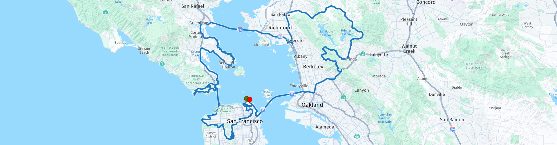
 I have further supplemented the Road Trip with even more special points that you can visit in the USA. Today we drive a tour that starts and ends in San Francisco, where we drive over all three bridges of San Francisco Bay. It is a ride of 185 kilometers.
We drive on beautiful winding roads with sometimes a stretch of highway. Along the way you will enjoy beautiful views, beautiful nature, there are several sights to visit and many beautiful viewpoints. I rate this route 5 stars.
 Share this route


Animation

Verdict


Duration
8h 55m

Mode of travel
Car or motorcycle

Distance
185.69 km

Countries

 RouteXpert Review
 The starting point is “Fisherman's Wharf”, a beautiful location close to the hotel. The first stop is after just a few minutes at “Cable Car Turntable Hyde & Beach”. San Francisco's Cable Car system is the world's last manually operated cable car system and an icon of the city of San Francisco. Of the 23 cable car lines built between 1873 and 1890, only three remain (one of which combines parts of two earlier lines): two routes from downtown near Union Square to Fisherman's Wharf, and a third route along California Street.
We only stop to take a photo, but it is recommended that you make the drive to Powell Street. Although the cable cars are used to some extent by commuters, the vast majority of the millions of passengers who use the system annually are tourists. The ride costs ~$12. San Francisco's cable cars are listed on the National Register of Historic Places.
We pass Ghirardelli Square, a landmark public square with shops and restaurants and a five-star hotel in the Marina District of San Francisco, California, United States. Part of the area was listed on the National Register of Historic Places in 1982 as Pioneer Woolen Mills and D. Ghirardelli Company. The square once housed more than 40 specialty shops and restaurants. Some of the original shops and restaurants are still located in the square.
Across from Ghirardelli Square is the San Francisco Maritime National Historical Park. This park includes a fleet of historic ships, a visitor center, a maritime museum and a library/research facility. Formerly called the San Francisco Maritime Museum, the collections were acquired by the National Park Service in 1978. The San Francisco Maritime National Historical Park was approved in 1988; the maritime museum is among the park's many cultural resources. The park also includes the Aquatic Park Historic District, bounded by Van Ness Avenue, Polk Street and Hyde Street.
We stop to climb the Coit Tower, this observation tower on Telegraph Hill is 64 meters high and was built in 1934. The art deco tower, made of reinforced concrete, was designed by the architects Arthur Brown Jr and Henry Howard. The wealthy Lillie Hitchcock Coit honored the brave firefighters of San Francisco. At her death in 1929, she left the city $100,000 for city beautification. The donation was ultimately used in 1934 to build the 64-meter-high Coit Tower in honor of the volunteer fire department.
The legend that the Coit Tower was built in honor of the firefighters is only partially true. In addition, the tower also served as an ornament of the city and as an observation tower from which one could enjoy a panorama of San Francisco. According to folk tales, the shape of the tower deliberately resembles that of the end of a fire hose. However, this was never the architects' intention.
We drive through the narrow streets of San Francisco with its steep hills and beautiful houses. We drive along the winding part of Lombard Street, past the free-access Cable Car Museum in the Nob Hill district. The Museum contains historical exhibits about San Francisco's cable car system, which can be considered a working museum in its own right. We pass several beautiful parks that San Francisco has to offer and along Columbus Avenue with a beautiful view of the Transamerica Pyramid.
This skyscraper was the tallest skyscraper in the city until 2017. That year, the Transamerica Pyramid was overtaken by the Salesforce Tower. The building was designed by William Pereira. The pyramid is 260 meters high and consists of 48 floors. Although the building is no longer the headquarters of the Transamerica Corporation, it is still strongly associated with that company. More than 1,500 employees work in the building, at more than 50 companies.
The building has become one of the symbols of San Francisco. The shape of the building has been chosen to hinder light entering the street as little as possible. The wings that extend on either side start on the 29th floor. The elevator shafts are located in the east wing and the stairwell and ventilation shafts are located in the west wing. The wings were necessary because elevators at the time could not go up at an angle.
Another iconic building on Columbus Avenue is the Columbus Tower, also called the Sentinel Building. Completed in 1907, this building features a distinctive copper-green Flatiron-style structure and is bounded by Columbus Avenue, Kearny Street, and Jackson Street; spread across the North Beach, Chinatown and Financial District neighborhoods. Much of the building is occupied by film studio American Zoetrope, and on the ground floor there is a café named after the company. It is listed as San Francisco Designated Landmark No. 33.
We visit Haight-Ashbury, named after the intersection of Haight and Ashbury streets. It is also called The Haight and The Upper Haight. The district is known as one of the main centers of the 1960s counterculture. The neighborhood generally includes the area surrounding Haight Street, bounded by Stanyan Street and Golden Gate Park to the west, Oak Street and the Golden Gate Park Panhandle to the north, Baker Street and Buena Vista Park to the east, and Frederick Street and Ashbury Heights and Cole Valley neighborhoods to the south. The street names commemorate two early leaders of San Francisco: pioneer and exchange banker Henry Haight, and Munroe Ashbury, a member of the San Francisco Board of Supervisors from 1864 to 1870.
Haight-Ashbury would later become known for its role as one of the major centers of the hippie movement. The Summer of Love (1967) and much of the 1960s counterculture have since become synonymous with San Francisco and the Haight-Ashbury neighborhood. Stroll through this colorful neighborhood and visit the shops.
We drive to the top of the Twin Peaks, two prominent hills with a height of approximately 282 meters that are located near the geographical center of San Francisco. The Twin Peaks are the city's second and third highest mountains; Only 283 meters (928 feet) Mount Davidson is higher within San Francisco city limits. The North and South Twin Peaks, also known as "Eureka" and "Noe" respectively, are approximately 650 feet apart. Enjoy the view of San Francisco.
There are many restaurants close to Golden Gate Park, so it is an excellent place to plan a lunch before we drive through the park. Here you can visit Hagiwara Tea Garden, a Japanese Tea Garden that was originally built as part of a sprawling World's Fair, the California Midwinter International Exposition of 1894. Although many of the attractions are still part of the garden today, there are There have been changes throughout the garden's history that have shaped it into what it is today.
The oldest public Japanese garden in the United States, this complex of many paths, ponds and a teahouse features plants and trees pruned and arranged in Japanese style. The 3-hectare garden contains sculptures and structures influenced by Buddhist and Shinto religious beliefs, as well as many water and rock elements to create a soothing landscape designed to help people relax.
We drive through Golden Gate Park to the coast where we visit the Cliff House, Camera Obscura and Seal Rock. Enjoy views of Seal Rock and visit the Camera Obscura behind the Cliff House, a device based on a design by Leonardo da Vinci that produces 360-degree live spectacular views of the waters around Seal Rock. The Cliff House is a neoclassical style building located on the headland above the cliffs just north of Ocean Beach. The building overlooks the site of the Sutro Baths ruins, Seal Rocks, and is part of the Golden Gate National Recreation Area.
Near Cliff House are the ruins of the Sutro Baths, designed by self-made millionaire Adolph Sutro in 1894. With his special interest in natural history and marine studies, he built an ocean pool aquarium among the rocks north of the Cliff House. Sutro then expanded his oceanfront complex by building a huge public bathhouse that covered three hectares and boasted impressive technical and artistic details.
It contained seven pools of different temperatures. There were slides, trapezes, springboards and a high dive. For all their glamor and excitement, the Baths were not commercially successful in the long term. The concrete ruins are the remains of the great Sutro Baths and have been part of the Golden Gate National Recreation Area since 1973.
We leave San Francisco via the iconic Golden Gate Bridge to visit the part of the Golden Gate National Recreation Area on the north side of San Francisco Bay. Here are several defense batteries, scenic lookouts and SF-88, a former Nike Missile launch site at Fort Barry. Opened in 1954, the site was intended to protect the population and military installations of the San Francisco Bay Area during the Cold War, particularly from Soviet bomber attacks. The site was originally armed with Nike Ajax missiles, and in 1958 modifications were made to the site so that it could also be armed with Nike Hercules missiles. In 1974, SF-88 was closed, but not demolished. It is now part of the Golden Gate National Recreation Area and is open to visitors. Visiting day is Saturday from 12:30 PM - 3:30 PM, with formal tours taking place every 45 minutes. A special open house day with Nike veterans takes place every first Saturday of the month. On the other Saturdays, volunteers carry out restoration work at the location.
You can visit the Point Bonita Lighthouse, this lighthouse is located at the entrance to San Francisco Bay in the Marin Headlands. Point Bonita was the last manned lighthouse on the California coast. It was added to the National Register of Historic Places in 1991. Getting there is a challenge, parking is limited and the 0.5 mile hike is steep and challenging. This place, at the “world's end”, is rugged, beautiful and worth a visit.
We drive via Sausalito around Richardson Bay to Belvedere-Tiburon where we drive the beautiful winding Paradise Drive through the Tiburon-Uplands Nature Reserve and Paradise Beach Park. This road is also a favorite with cyclists, so keep that in mind and enjoy the beautiful ride and surroundings.
We drive over the beautiful Richmond-San Rafael Bridge over San Francisco Bay. It is the northernmost east-west bridge across the bay. It is 5.5 miles (8.9 km) long and connects San Rafael in the west to Richmond in the east. Enjoy the view over the bay during the ride.
In Richmond we drive towards San Pablo where we leave the highway and drive around the Wildcat Canyon Regional Park, through Pinole Valley Park, Briones Regional Park, Tildon Nature Area and Claremont Canyon. This is a beautiful green, forested and mountainous part north of Oakland. Enjoy the ride, just watch out for other traffic if you want to stop to enjoy the view.
In Oakland we take the San Francisco-Oakland Bay Bridge, known locally as the Bay Bridge, and one of the longest bridge spans in the United States. The toll bridge ($7) opened on Thursday, November 12, 1936, six months before the Golden Gate Bridge. The bridge has 2 decks and halfway between them is Treasure Island, an artificial island in San Francisco Bay, and a neighborhood in the city and county of San Francisco. The island was built in 1936-37 for the 1939 Golden Gate International Exposition and was named by Clyde Milner Vandeburg, part of the fair's public relations team.
The site of the World's Fair is a historic landmark in California. Buildings there are listed on the National Register of Historic Places, and the historic Naval Station Treasure Island, an auxiliary air facility (for airships, zeppelins, dirigibles, airplanes, and seaplanes), is designated in the Geographic Names Information System. Treasure Island is connected by causeway to Yerba Buena Island, another San Francisco subsidiary island.
On the other side of the Bay Bridge we arrive back in San Francisco. Here we drive via the Embarcadero along the northeast coast of San Francisco. The road is approximately 4.6 kilometers long. The name refers to the section of the city along Embarcadero Road, which is built on land reclaimed from the bay. The most recognizable structure of the Embarcadero is the Ferry Building, with many nice shops and restaurants.
Four of the piers along the Embarcadero were placed on the National Register of Historic Places. Alcatraz City Cruises is located at Pier 33, they offer various cruises to Alcatraz, or The Rock. Plan about half a day during your stay in San Francisco to explore Alcatraz Island, visit the world-famous Cellhouse, step back in time and experience the legendary island that was a Civil War fort, a military prison and one of the most infamous federal prisons have been in American history. This is a must-do when in San Francisco.
An important tourist attraction on the Embarcadero is Pier 39, which is also the end point of this ride. This is a shopping area and tourist attraction built on a pier in San Francisco. There are several shops, restaurants, an arcade, buskers and street theater, an information center for the Marine Mammal Center, the Aquarium of the Bay and a two-story merry-go-round. Pier 39 is also known for its colony of California sea lions. Pier 39 is one of San Francisco's top tourist destinations, so there is always something going on here and it is very busy.


 Links
Links  Usage
Usage Want to download this route?
You can download the route for free without MyRoute-app account. To do so, open the route and click 'save as'. Want to edit this route?
No problem, start by opening the route. Follow the tutorial and create your personal MyRoute-app account. After registration, your trial starts automatically.  Disclaimer
Use of this GPS route is at your own expense and risk. The route has been carefully composed and checked by a MyRoute-app accredited RouteXpert for use on TomTom, Garmin and MyRoute-app Navigation.
Changes may nevertheless have occurred due to changed circumstances, road diversions or seasonal closures. We therefore recommend checking each route before use.
Preferably use the route track in your navigation system. More information about the use of MyRoute-app can be found on the website under 'Community' or 'Academy'.

California
About this region
California is a state in the Western United States. It shares a border with Oregon to the north, Nevada and Arizona to the east, and the Mexican state of Baja California to the south. With over 39.5 million residents across a total area of approximately 163,696 square miles (423,970 km2), it is the most populous and the third-largest U.S. state by area. It is also the most populated subnational entity in North America and the 34th most populous in the world. The Greater Los Angeles area and the San Francisco Bay Area are the nation's second and fifth most populous urban regions respectively, with the former having more than 18.7 million residents and the latter having over 9.6 million. Sacramento is the state's capital, while Los Angeles is the most populous city in the state and the second most populous city in the country (after New York City). Los Angeles County is the country's most populous, while San Bernardino County is the largest county by area in the country. San Francisco, which is both a city and a county, is the second most densely populated major city in the country (after New York City) and the fifth most densely populated county in the country, behind four of New York City's five boroughs.
The economy of California, with a gross state product of $3.2 trillion as of 2019, is the largest sub-national economy in the world. If it were a country, it would be the 37th most populous country and the fifth largest economy as of 2020. The Greater Los Angeles area and the San Francisco Bay Area are the nation's second- and third-largest urban economies ($1.0 trillion and $0.5 trillion respectively as of 2020), after the New York metropolitan area ($1.8 trillion). The San Francisco Bay Area Combined Statistical Area had the nation's highest gross domestic product per capita ($106,757) among large primary statistical areas in 2018, and is home to five of the world's ten largest companies by market capitalization and four of the world's ten richest people.Prior to European colonization, California was one of the most culturally and linguistically diverse areas in pre-Columbian North America and contained the highest Native American population density north of what is now Mexico. European exploration in the 16th and 17th centuries led to the colonization of California by the Spanish Empire. In 1804, it was included in Alta California province within the Viceroyalty of New Spain. The area became a part of Mexico in 1821, following its successful war for independence, but was ceded to the United States in 1848 after the Mexican–American War. The western portion of Alta California was then organized and admitted as the 31st state on September 9, 1850, following the Compromise of 1850. The California Gold Rush started in 1848 and led to dramatic social and demographic changes, including large-scale immigration into California, a worldwide economic boom, and the California genocide of indigenous people.
Notable contributions to popular culture, for example in entertainment and sports, have their origins in California. The state also has made noteworthy contributions in the fields of communication, information, innovation, environmentalism, economics, and politics. It is the home of Hollywood, the oldest and largest film industry in the world, which has had a profound effect on global entertainment. It is considered the origin of the hippie counterculture, beach and car culture, and the personal computer, among other innovations. The San Francisco Bay Area and the Greater Los Angeles Area are widely seen as centers of the global technology and entertainment industries, respectively. California's economy is very diverse: 58% of it is based on finance, government, real estate services, technology, and professional, scientific, and technical business services. Although it accounts for only 1.5% of the state's economy, California's agriculture industry has the highest output of any U.S. state. California's ports and harbors handle about a third of all U.S. imports, most originating in Pacific Rim international trade.
The state's extremely diverse geography ranges from the Pacific Coast and metropolitan areas in the west to the Sierra Nevada mountains in the east, and from the redwood and Douglas fir forests in the northwest to the Mojave Desert in the southeast. The Central Valley, a major agricultural area, dominates the state's center. Although California is well known for its warm Mediterranean climate and monsoon seasonal weather, the large size of the state results in climates that vary from moist temperate rainforest in the north to arid desert in the interior, as well as snowy alpine in the mountains. All these factors lead to an enormous demand for water. Over time, droughts and wildfires have increased in frequency and become less seasonal and more year-round, further straining California's water security.
Read more on Wikipedia
The economy of California, with a gross state product of $3.2 trillion as of 2019, is the largest sub-national economy in the world. If it were a country, it would be the 37th most populous country and the fifth largest economy as of 2020. The Greater Los Angeles area and the San Francisco Bay Area are the nation's second- and third-largest urban economies ($1.0 trillion and $0.5 trillion respectively as of 2020), after the New York metropolitan area ($1.8 trillion). The San Francisco Bay Area Combined Statistical Area had the nation's highest gross domestic product per capita ($106,757) among large primary statistical areas in 2018, and is home to five of the world's ten largest companies by market capitalization and four of the world's ten richest people.Prior to European colonization, California was one of the most culturally and linguistically diverse areas in pre-Columbian North America and contained the highest Native American population density north of what is now Mexico. European exploration in the 16th and 17th centuries led to the colonization of California by the Spanish Empire. In 1804, it was included in Alta California province within the Viceroyalty of New Spain. The area became a part of Mexico in 1821, following its successful war for independence, but was ceded to the United States in 1848 after the Mexican–American War. The western portion of Alta California was then organized and admitted as the 31st state on September 9, 1850, following the Compromise of 1850. The California Gold Rush started in 1848 and led to dramatic social and demographic changes, including large-scale immigration into California, a worldwide economic boom, and the California genocide of indigenous people.
Notable contributions to popular culture, for example in entertainment and sports, have their origins in California. The state also has made noteworthy contributions in the fields of communication, information, innovation, environmentalism, economics, and politics. It is the home of Hollywood, the oldest and largest film industry in the world, which has had a profound effect on global entertainment. It is considered the origin of the hippie counterculture, beach and car culture, and the personal computer, among other innovations. The San Francisco Bay Area and the Greater Los Angeles Area are widely seen as centers of the global technology and entertainment industries, respectively. California's economy is very diverse: 58% of it is based on finance, government, real estate services, technology, and professional, scientific, and technical business services. Although it accounts for only 1.5% of the state's economy, California's agriculture industry has the highest output of any U.S. state. California's ports and harbors handle about a third of all U.S. imports, most originating in Pacific Rim international trade.
The state's extremely diverse geography ranges from the Pacific Coast and metropolitan areas in the west to the Sierra Nevada mountains in the east, and from the redwood and Douglas fir forests in the northwest to the Mojave Desert in the southeast. The Central Valley, a major agricultural area, dominates the state's center. Although California is well known for its warm Mediterranean climate and monsoon seasonal weather, the large size of the state results in climates that vary from moist temperate rainforest in the north to arid desert in the interior, as well as snowy alpine in the mountains. All these factors lead to an enormous demand for water. Over time, droughts and wildfires have increased in frequency and become less seasonal and more year-round, further straining California's water security.
View region
 Statistics
  43
43Amount of RX reviews (California)
 29617
29617Amount of visitors (California)
 768
768Amount of downloads (California)
 Route Collections in this region
 Car or motorcycle tour through the western US
This collection contains all 15 routes driven by MRA Goldmember André ter Schegget during his three-week tour through the west of America.
The places to visit, the attractions and beautiful photo spots are nicely marked on the routes. The routes have been fully checked and made equal for the Garmin and the TomTom. Enjoy this wonderful trip and let us know how it was! Enjoy and stay safe!
Order of the tour:
Route 01: from Los Angeles and via Pacific Coast Highway to Solvang
Route 02: Solvang to Monterey / Pacific Grove
Route 03A: Monterey to San Francisco
Route 03B: if you are by car instead of the motorcycle, as motorcycles are not allowed on the 17 Mile Drive: from Monterey to the 17 Mile Drive and further to San Francisco
Route 04: from San Francisco via Nappa and Eldorado National Forrest to Topaz Lake
Route 05: from Topaz Lake via Bodie and Yosemite to Oakhurst
Route 06: from Oakhurst via Kings Canyon NP and Sequoia NP and Giant Forest to Exeter
Route 07: Exeter via Isabella Lake and Ridgecrest to Death Valley
Route 08: from Death Valley via Valley Of Fire to Mesquite
Route 09: from Mesquite via Zion NP and Dixie NF to Hatch
Route 10: Hatch via Bryce Canyon to Page
Route 11: from Page via Grand Canyon to Williams
Route 12: from Williams via Seligman and Route 66 to Kingman and via Hoover Dam to Las Vegas
Route 13: from Las Vegas via Oatman and Lake Havasu to Parker
Route 14: from Parker via Joshua Tree to Rancho Mirage
Route 15: Rancho Mirage via Palm Springs to Santa Monica
View Route Collection
The 10 most downloaded routes in the USA from RouteXpert Hans van de Ven
Hello and welcome to this collection of the Top 10 MyRoute app downloaded routes in USA.
There will be a great new event to be announced soon, where all these routes can be driven.
Download them all now and place them in a new "Top 10" folder, so that you always have them at hand.
If you are going to drive one of these routes in the meantime, track them with the MRA Mobile App or with MRA Navigation. Take some photos (moments) along the way as these will come in handy.
Create a travelogue of your Top 10 driven routes and add the recorded track to it.
There will also be some great prizes on offer, so keep an eye on the MRA-RouteXperts page and your mail.
The 10 routes are:
1. D13 Estes Park Denver
2. D03 Chadron Custer
3. D01 Pigeon Forge round trip through the Smokey Mountains
4. D08 Kalispell Sandpoint
5. D10 Colville Wenatchee
6. D09 Sandpoint Colville
7. D04 Custer Wall
8. D11 Wenatchee Seattle
9. D08 Cody Yellowstone NP
10.R13 San Francisco Monterey
View Route Collection