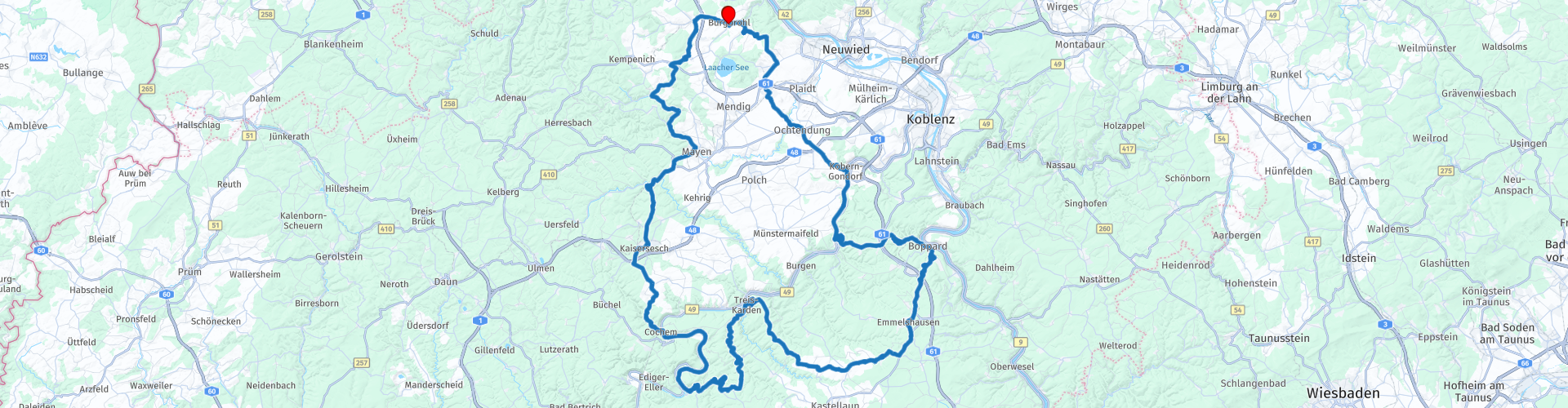
Eifel Roundtour Burgbrohl to Cochem at the Mosel

This route was brought to you by:
RouteXpert Guy Heyns - Adv. RouteXpert
Last edit: 31-12-2024
 Route Summary
 The environment you are driving in is particularly beautiful and the asphalt is absolutely of the quality we are used to in Germany.
Because of the beauty of the route and the many beautiful things to see along the way, we are happy to give this route 5 stars, also because it is easily doable for everyone.
Cochem is a very nice town on the banks of the Moselle where it is pleasant to stay and the attraction for many tourists is therefore obvious.
 Share this route


Animation

Verdict


Duration
7h 17m

Mode of travel
Car or motorcycle

Distance
202.26 km

Countries

 RouteXpert Review
 You pass the first petrol station quite soon, after which wonderfully rolling roads take you through vast forests towards Schloss Bürresheim, a beautiful medieval castle that has survived the ravages of time. It is one of three castles in the Eifel that have never been destroyed. The castle was privately owned until 1921 and is now managed by the local cultural organisation. It has been completely restored, including the gardens, and is well worth a visit if you are interested. Fun fact: Indiana Jones' father, played by Sean Connery, was held here by the Nazis in 'Indiana Jones and the Last Crusade', a very famous film from 1989.
After this passage you have to go through the urban area of Mayen, but with a bit of luck you will be through it. It does not take long before you are riding through the woods again while passing typical Eifel villages. When you start the steep (but long-running) descent you know that you are approaching Cochem on the Moselle.
Cochem is a small but charming town with nice medieval alleys, cozy cafes and beautiful half-timbered houses. Although it attracts the most tourists, Bernkastel is also a formidable competitor when it comes to 'picturesque'. Both Eifel villages are therefore certainly worth a visit. On this route, however, we stay in Cochem, which is dominated by the castle 'Reichsburg', built around 1020. At that time, Cochem flourished as a medieval walled town where the local wine was traded and brought in a lot of money. With this money, many half-timbered houses were built between the 13th and 15th century and these can still be admired today, certainly on the market place of Cochem. Today, Cochem is still the main town for the Moselle wines.
The castle itself, the Reichsburg, was besieged, captured and blown up by French troops in 1689 during the Nine Years' War. The French are experts at destroying other people's property. In 1868, the castle was bought by Berlin businessman Louis Fréderic Jacques Ravené. He had the castle rebuilt in neo-Gothic style with the intention of it becoming a summer residence for his family. Eventually, in 1942, the castle was sold to the government, and after the war it came into the hands of the state of Rhineland-Palatinate. In 1987, the city finally bought the castle, and since then it has been home to a museum. A number of rooms in the castle are decorated in neo-Renaissance and neo-Baroque style, and various pieces of furniture, paintings, tapestries and other objects are on display.
If you want to visit the castle, a short walk or the shuttle bus is the solution. You can't drive there.
For the 'gold-diggers' there is another interesting place to visit in Cochem... The Bundesbank-Bunker, an underground nuclear bunker from the Cold War...
This bunker was built in 1962 at a depth of 30 m below ground, above which two houses were subsequently built which were to serve as training and recreation facilities for Bundesbank employees.
The bunker housed Germany's secret money supply between 1965 and the end of the 1980s. In total, 15 billion Marks were stored in the bunker, which could be used if the Eastern Bloc tried to sabotage the West German economy. To open the vault, 3 separate keys were needed, which employees from Frankfurt had in their possession. Allow about an hour for a possible visit. Please note that there is no parking at the bunker itself. A walk is also recommended here.
After Cochem we ride for 17 kilometers along the Moselle and then we ride up the opposite slope. Super fun (and a bit technical) riding through beautiful nature, after which another section follows to say goodbye to the Moselle at Treis-Karden. Here you can plan a lunch stop in one of the establishments in the village if necessary.
After the lunch stop we make a technical detour to the big brother of the Mosel, the almighty Rhine. Before that we cross the next mountain to ride up and down it again after approaching the Rhine (you unfortunately do not see the river itself through the forests and the buildings). Wonderful motorcycling in the hilly area of the Eifel!
A final passage along the Moselle then takes you to Kobern, where a final coffee stop can be made before returning to the hotel in Burgbrohl.


 Links
Links  Usage
Usage Want to download this route?
You can download the route for free without MyRoute-app account. To do so, open the route and click 'save as'. Want to edit this route?
No problem, start by opening the route. Follow the tutorial and create your personal MyRoute-app account. After registration, your trial starts automatically.  Disclaimer
Use of this GPS route is at your own expense and risk. The route has been carefully composed and checked by a MyRoute-app accredited RouteXpert for use on TomTom, Garmin and MyRoute-app Navigation.
Changes may nevertheless have occurred due to changed circumstances, road diversions or seasonal closures. We therefore recommend checking each route before use.
Preferably use the route track in your navigation system. More information about the use of MyRoute-app can be found on the website under 'Community' or 'Academy'.

Rheinland Pfalz
About this region
Rhineland-Palatinate (German: Rheinland-Pfalz, [ˈʁaɪ̯nlant ˈp͡falt͡s] (listen)) is a western state of Germany. It covers 19,846 km2 (7,663 sq mi) and has about 4.05 million residents. It is the ninth largest and sixth most populous of the sixteen states. Mainz is the capital and largest city. Other cities are Ludwigshafen am Rhein, Koblenz, Trier, Kaiserslautern and Worms. It is bordered by North Rhine-Westphalia, Saarland, Baden-Württemberg and Hesse and by the countries France, Luxembourg and Belgium.
Rhineland-Palatinate was established in 1946 after World War II, from parts of the former states of Prussia (part of its Rhineland province), Hesse and Bavaria (its former outlying Palatinate kreis or district), by the French military administration in Allied-occupied Germany. Rhineland-Palatinate became part of the Federal Republic of Germany in 1949 and shared the country's only border with the Saar Protectorate until the latter was returned to German control in 1957. Rhineland-Palatinate's natural and cultural heritage includes the extensive Palatinate winegrowing region, picturesque landscapes, and many castles and palaces.
Read more on Wikipedia
Rhineland-Palatinate was established in 1946 after World War II, from parts of the former states of Prussia (part of its Rhineland province), Hesse and Bavaria (its former outlying Palatinate kreis or district), by the French military administration in Allied-occupied Germany. Rhineland-Palatinate became part of the Federal Republic of Germany in 1949 and shared the country's only border with the Saar Protectorate until the latter was returned to German control in 1957. Rhineland-Palatinate's natural and cultural heritage includes the extensive Palatinate winegrowing region, picturesque landscapes, and many castles and palaces.
View region
 Statistics
  132
132Amount of RX reviews (Rheinland Pfalz)
 41188
41188Amount of visitors (Rheinland Pfalz)
 24503
24503Amount of downloads (Rheinland Pfalz)
 Route Collections in this region
 Top 5 Car and Motorcycle Routes in the Eifel
The Eifel is the eastern part of the medium plateau Eifel-Ardennes. It is located north of the Moselle and west of the Rhine. The largest part is in Germany, a small part is in Belgium, in the East Cantons. The German part of Eifel is located in the federal states of North Rhine-Westphalia and Rhineland-Palatinate. The highest point is the Hohe Acht with 747 meters.
Several chains can be distinguished in the Eifel:
The northernmost part is called the Nordeifel, which in Belgium connects to the High Fens;
To the east of this is the Ahrgebirge, this part is located north of the Ahr in the Ahrweiler district;
South of the Ahr is the Hohe Eifel (or Hocheifel), of which the Hohe Acht (747 m) is the highest point, and also the highest point in the entire Eifel region;
To the west, near the Belgian border, the hills are known as Schneifel, part of the wider Snow Eifel area with peaks reaching up to 698 metres;
South and east of the Hohe Eifel is the Volcano-Eifel, a volcanic area with many crater lakes (Maare).
The southern part of the Eifel is less high. The area is bisected by streams and rivers running southwards. These streams flow into the Moselle. The largest of these rivers is the Kyll; the hills around this river are known as the Kyllwald;
In the south, the Eifel ends in the Voreifel.
In the north of the Eifel there are some large reservoirs. The largest of these is the reservoir in the Roer that was created by the construction of the Roerdal dam.
The Nürburgring is also located in the Eifel, a well-known car circuit for Formula 1 races, among other things. Since 2004, part of the north of the Eifel has become the Eifel National Park. This National Park falls entirely within the German-Belgian nature park High Fens-Eifel. Another part of the Eifel falls within the South Eifel Nature Park.
Well-known throughout the Netherlands and Belgium by car and motorcyclists, so reason enough for the MyRoute app RouteXpert to compile a Top 5 of Car and Motorbike routes for you.
All routes in this collection have been checked and made equal for TomTom, Garmin and MyRoute-app Navigation by a MyRoute-app RouteXpert.
If you think, I have a very nice route that should certainly not be missing from this collection, send it to:
email: routeexpert@myrouteapp.com
Subject: New Route for the Top 5 collection Eifel composed by Hans van de Ven.
The route will then be reviewed and then added to the Top 5. To make the Top 5 also the Top 5, 1 route will have to disappear from the Top 5, you can indicate this when submitting the new route.
Have fun with this collection and while driving one of these routes. Enjoy all the beauty that the Eifel has to offer. Click on “View route” to read the review of the chosen route.
I would like to hear your findings about the route(s).
View Route Collection
Route collection hairpins in the Eifel
This collection is composed of the most beautiful and winding roads in the Eifel. Forget Bundesstraßen, forget the road along the Moselle, if you have driven these roads, you can really say that you have been to the Eifel.
No less than 6 routes and 1,800 kilometers are waiting for you!
No less than 6 routes and 1,800 kilometers are waiting for you!
View Route Collection