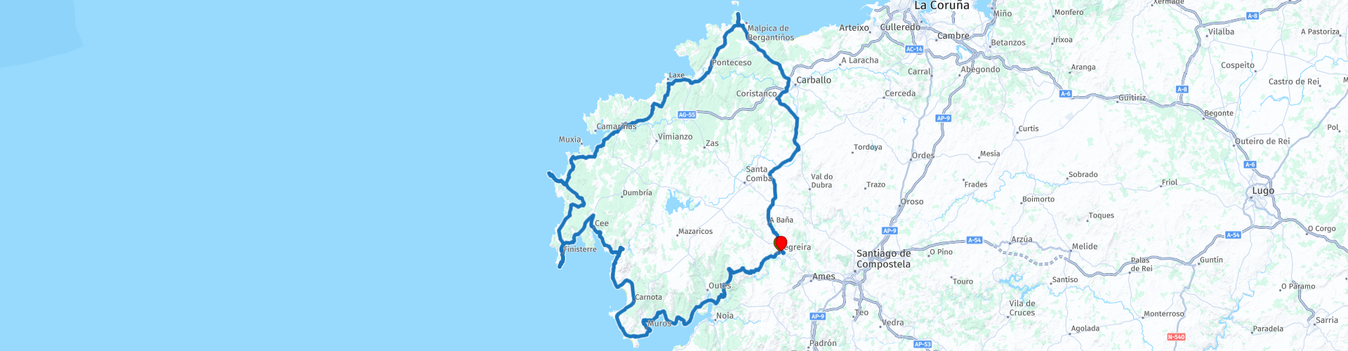
Round trip from Negreira

This route was brought to you by:
RouteXpert Nick Carthew - (MRA Master)
Last edit: 23-12-2020
 Route Summary
  Share this route


Animation

Verdict


Duration
6h 43m

Mode of travel
Car or motorcycle

Distance
283.48 km

Countries

 RouteXpert Review
 This route starts from Negreira and heads towards the spectacular coastline that this area is known for by following the DP-5602. This road is surfaced along it's entire length but is very narrow in places as you pass through the forestry areas. It has a feeling of a forest trail in places as the trees are so close and the road so narrow, very enjoyable though. The route reaches the coast and then you cross over the Lancano Bridge and follow the coastline. There are many view points to stop for photo's and a particularly good one is at RP 9 where you have the spectacular coast in front of you and a great view of the Xallas Dam behind you.
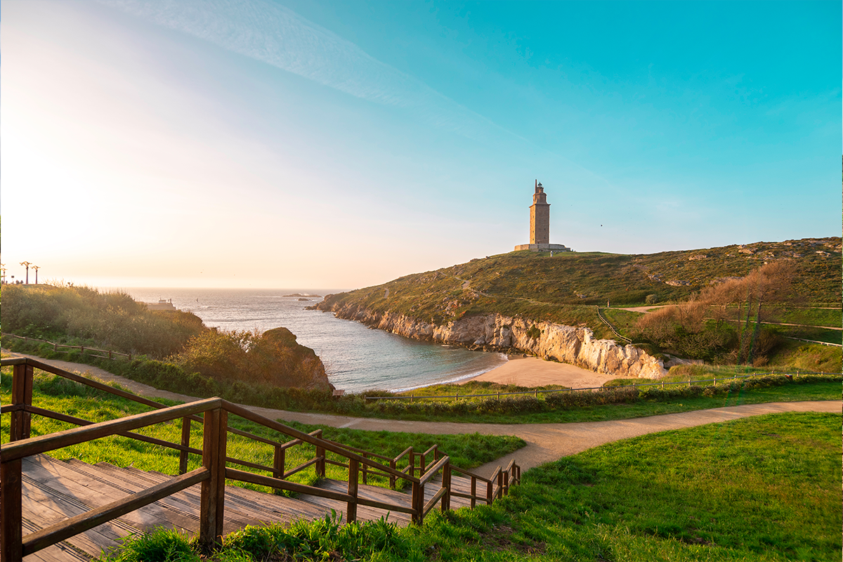
The route now heads for Cape Finisterre which is the last stopover for pilgrims who make a pilgrimage to Santiago de Compostela. The legendary Lighthouse of Finisterre was constructed in the year of 1853 at the tip of Cape Finisterre. When the skies are clear and the sun is shining brightly, one can enjoy the view of the famous Galician lighthouse from up to 30 kilometers out at sea. The lighthouse is a reminder of numerous marine battles that occurred between the French and English around the cape. Furthermore, countless shipwrecks from ancient and current times rest on the bottom of the Atlantic. Due to its bloody history and jagged coastline, the jagged coast of Finisterre is often, aptly called the Coast of Death.
I would suggest a lunch stop at Finisterre after visiting the lighthouse, there are many restaurants there with something to please everyone.
Further up the coast is Cape Touriñan, the most western point in Spain and another lighthouse. The western point of the cape, called Os Buxeirados, has a series of rocks that go into the sea around 300 to 400 metres, known as A Laxe de Buxeirados or Bajos de Buxeirados. These rocks have proved dangerous for navigation, causing some serious shipwrecks.
We head to the end of the Death Coast now and visit the remote and exposed chapel St Adrián at RP 22 with beautiful coastal views.
The route now heads back to the start point at Negreira using a mixture of rural and trunk roads.
I have awarded this route with 4 stars**** The roads are good and the scenery and attractions are very good.


 Usage
Usage Want to download this route?
You can download the route for free without MyRoute-app account. To do so, open the route and click 'save as'. Want to edit this route?
No problem, start by opening the route. Follow the tutorial and create your personal MyRoute-app account. After registration, your trial starts automatically.  Disclaimer
Use of this GPS route is at your own expense and risk. The route has been carefully composed and checked by a MyRoute-app accredited RouteXpert for use on TomTom, Garmin and MyRoute-app Navigation.
Changes may nevertheless have occurred due to changed circumstances, road diversions or seasonal closures. We therefore recommend checking each route before use.
Preferably use the route track in your navigation system. More information about the use of MyRoute-app can be found on the website under 'Community' or 'Academy'.
Galicia
About this region
Galicia (; Galician: Galicia [ɡaˈliθjɐ] or Galiza [ɡaˈliθɐ]; Spanish: Galicia, Portuguese: Galiza) is an autonomous community of Spain and historic nationality under Spanish law. Located in the northwest Iberian Peninsula, it includes the provinces of A Coruña, Lugo, Ourense and Pontevedra.
Galicia is located in Atlantic Europe. It is bordered by Portugal to the south, the Spanish autonomous communities of Castile and León and Asturias to the east, the Atlantic Ocean to the west, and the Cantabrian Sea to the north. It had a population of 2,701,743 in 2018 and a total area of 29,574 km2 (11,419 sq mi). Galicia has over 1,660 km (1,030 mi) of coastline, including its offshore islands and islets, among them Cíes Islands, Ons, Sálvora, Cortegada Island, which together form the Atlantic Islands of Galicia National Park, and the largest and most populated, A Illa de Arousa.
The area now called Galicia was first inhabited by humans during the Middle Paleolithic period, and takes its name from the Gallaeci, the Celtic people living north of the Douro River during the last millennium BC. Galicia was incorporated into the Roman Empire at the end of the Cantabrian Wars in 19 BC, and was made a Roman province in the 3rd century AD. In 410, the Germanic Suebi established a kingdom with its capital in Braga (Portugal); this kingdom was incorporated into that of the Visigoths in 585. In 711, the Islamic Umayyad Caliphate invaded the Iberian Peninsula conquering the Visigoth kingdom of Hispania by 718, but soon Galicia was incorporated into the Christian kingdom of Asturias by 740. During the Middle Ages, the kingdom of Galicia was occasionally ruled by its own kings, but most of the time it was leagued to the kingdom of Leon and later to that of Castile, while maintaining its own legal and customary practices and culture. From the 13th century on, the kings of Castile, as kings of Galicia, appointed an Adiantado-mór, whose attributions passed to the Governor and Captain General of the Kingdom of Galiza from the last years of the 15th century. The Governor also presided the Real Audiencia do Reino de Galicia, a royal tribunal and government body. From the 16th century, the representation and voice of the kingdom was held by an assembly of deputies and representatives of the cities of the kingdom, the Cortes or Junta of the Kingdom of Galicia. This institution was forcibly discontinued in 1833 when the kingdom was divided into four administrative provinces with no legal mutual links. During the 19th and 20th centuries, demand grew for self-government and for the recognition of the culture of Galicia. This resulted in the Statute of Autonomy of 1936, soon frustrated by Franco's coup d'etat and subsequent long dictatorship. After democracy was restored the legislature passed the Statute of Autonomy of 1981, approved in referendum and currently in force, providing Galicia with self-government.
The interior of Galicia is characterized by a hilly landscape; mountain ranges rise to 2,000 m (6,600 ft) in the east and south. The coastal areas are mostly an alternate series of rias and beaches. The climate of Galicia is usually temperate and rainy, with markedly drier summers; it is usually classified as Oceanic. Its topographic and climatic conditions have made animal husbandry and farming the primary source of Galicia's wealth for most of its history, allowing for a relative high density of population. With the exception of shipbuilding and food processing, Galicia was based on a farming and fishing economy until after the mid-20th century, when it began to industrialize. In 2018, the nominal gross domestic product was €62,900 million, with a nominal GDP per capita of €23,300. Galicia is characterised, unlike other Spanish regions, by the absence of a metropolis dominating the territory. Indeed, the urban network is made up of 7 main cities (the four provincial capitals A Coruña, Pontevedra, Ourense and Lugo, the political capital Santiago de Compostela and the industrial cities Vigo and Ferrol and other small towns. The population is largely concentrated in two main areas: from Ferrol to A Coruña in the northern coast, and in the Rías Baixas region in the southwest, including the cities of Vigo, Pontevedra, and the interior city of Santiago de Compostela. There are smaller populations around the interior cities of Lugo and Ourense. The political capital is Santiago de Compostela, in the province of A Coruña. Vigo, in the province of Pontevedra, is the largest municipality in Galicia, while A Coruña is the largest Galician city. · .Two languages are official and widely used today in Galicia: the native Galician, a Romance language closely related to Portuguese with which it shares the Galician-Portuguese medieval literature; and Spanish, usually called Castilian. While most Galicians are bilingual, a 2013 survey reported that 51% of the Galician population spoke Galician most often on a day-to-day basis, while 48% most often used Spanish.
Read more on Wikipedia
Galicia is located in Atlantic Europe. It is bordered by Portugal to the south, the Spanish autonomous communities of Castile and León and Asturias to the east, the Atlantic Ocean to the west, and the Cantabrian Sea to the north. It had a population of 2,701,743 in 2018 and a total area of 29,574 km2 (11,419 sq mi). Galicia has over 1,660 km (1,030 mi) of coastline, including its offshore islands and islets, among them Cíes Islands, Ons, Sálvora, Cortegada Island, which together form the Atlantic Islands of Galicia National Park, and the largest and most populated, A Illa de Arousa.
The area now called Galicia was first inhabited by humans during the Middle Paleolithic period, and takes its name from the Gallaeci, the Celtic people living north of the Douro River during the last millennium BC. Galicia was incorporated into the Roman Empire at the end of the Cantabrian Wars in 19 BC, and was made a Roman province in the 3rd century AD. In 410, the Germanic Suebi established a kingdom with its capital in Braga (Portugal); this kingdom was incorporated into that of the Visigoths in 585. In 711, the Islamic Umayyad Caliphate invaded the Iberian Peninsula conquering the Visigoth kingdom of Hispania by 718, but soon Galicia was incorporated into the Christian kingdom of Asturias by 740. During the Middle Ages, the kingdom of Galicia was occasionally ruled by its own kings, but most of the time it was leagued to the kingdom of Leon and later to that of Castile, while maintaining its own legal and customary practices and culture. From the 13th century on, the kings of Castile, as kings of Galicia, appointed an Adiantado-mór, whose attributions passed to the Governor and Captain General of the Kingdom of Galiza from the last years of the 15th century. The Governor also presided the Real Audiencia do Reino de Galicia, a royal tribunal and government body. From the 16th century, the representation and voice of the kingdom was held by an assembly of deputies and representatives of the cities of the kingdom, the Cortes or Junta of the Kingdom of Galicia. This institution was forcibly discontinued in 1833 when the kingdom was divided into four administrative provinces with no legal mutual links. During the 19th and 20th centuries, demand grew for self-government and for the recognition of the culture of Galicia. This resulted in the Statute of Autonomy of 1936, soon frustrated by Franco's coup d'etat and subsequent long dictatorship. After democracy was restored the legislature passed the Statute of Autonomy of 1981, approved in referendum and currently in force, providing Galicia with self-government.
The interior of Galicia is characterized by a hilly landscape; mountain ranges rise to 2,000 m (6,600 ft) in the east and south. The coastal areas are mostly an alternate series of rias and beaches. The climate of Galicia is usually temperate and rainy, with markedly drier summers; it is usually classified as Oceanic. Its topographic and climatic conditions have made animal husbandry and farming the primary source of Galicia's wealth for most of its history, allowing for a relative high density of population. With the exception of shipbuilding and food processing, Galicia was based on a farming and fishing economy until after the mid-20th century, when it began to industrialize. In 2018, the nominal gross domestic product was €62,900 million, with a nominal GDP per capita of €23,300. Galicia is characterised, unlike other Spanish regions, by the absence of a metropolis dominating the territory. Indeed, the urban network is made up of 7 main cities (the four provincial capitals A Coruña, Pontevedra, Ourense and Lugo, the political capital Santiago de Compostela and the industrial cities Vigo and Ferrol and other small towns. The population is largely concentrated in two main areas: from Ferrol to A Coruña in the northern coast, and in the Rías Baixas region in the southwest, including the cities of Vigo, Pontevedra, and the interior city of Santiago de Compostela. There are smaller populations around the interior cities of Lugo and Ourense. The political capital is Santiago de Compostela, in the province of A Coruña. Vigo, in the province of Pontevedra, is the largest municipality in Galicia, while A Coruña is the largest Galician city. · .Two languages are official and widely used today in Galicia: the native Galician, a Romance language closely related to Portuguese with which it shares the Galician-Portuguese medieval literature; and Spanish, usually called Castilian. While most Galicians are bilingual, a 2013 survey reported that 51% of the Galician population spoke Galician most often on a day-to-day basis, while 48% most often used Spanish.
View region
 Statistics
  3
3Amount of RX reviews (Galicia)
 18470
18470Amount of visitors (Galicia)
 92
92Amount of downloads (Galicia)