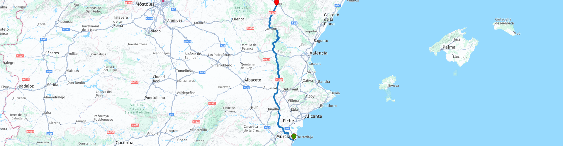
Torrevieja to Teruel

This route was brought to you by:
RouteXpert Nick Carthew - (MRA Master)
Last edit: 02-04-2021
 Route Summary
  Share this route


Animation

Verdict


Duration
6h 47m

Mode of travel
Car or motorcycle

Distance
373.71 km

Countries

 RouteXpert Review
 I have suggested a fuel and lunch stop at El Pontón RP 11. The La Brassa restaurant is next door to the gas station and they welcome motorcyclists.
After lunch the route takes a smaller road and heads towards the magnificent Benagéber reservoir at RP 14. The road is very twisty and has several hairpin bends. There is an opportunity to take pictures on the dam and anyone with a loud exhaust will appreciate the tunnel! This enormous reservoir is fed by the Rio Turia which we will meet up with again at RP 17 when we cross over it on a high bridge and follow its path, with more hairpins all the way to the hotel at Teruel.
The Hotel Isabel de Segura has 3*** is very comfortable and has secure parking. See the link below.
I have awarded this route 3 stars *** as the roads, scenery and attractions are all good.


 Links
Links  Usage
Usage Want to download this route?
You can download the route for free without MyRoute-app account. To do so, open the route and click 'save as'. Want to edit this route?
No problem, start by opening the route. Follow the tutorial and create your personal MyRoute-app account. After registration, your trial starts automatically.  Disclaimer
Use of this GPS route is at your own expense and risk. The route has been carefully composed and checked by a MyRoute-app accredited RouteXpert for use on TomTom, Garmin and MyRoute-app Navigation.
Changes may nevertheless have occurred due to changed circumstances, road diversions or seasonal closures. We therefore recommend checking each route before use.
Preferably use the route track in your navigation system. More information about the use of MyRoute-app can be found on the website under 'Community' or 'Academy'.

Castilla–La Mancha
About this region
Castilla–La Mancha (UK: , US: , Spanish: [kasˈtiʎa la ˈmantʃa] (listen)), or Castile La Mancha, is an autonomous community of Spain. Comprising the provinces of Albacete, Ciudad Real, Cuenca, Guadalajara and Toledo, it was created in 1982. The government headquarters are in Toledo.
The region largely occupies the southern half of the Iberian Peninsula's Inner Plateau, including large parts of the catchment areas of the Tagus, the Guadiana and the Júcar, while the northeastern relief comprises the Sistema Ibérico mountain massif.
It is bordered by Castile and León, Madrid, Aragon, Valencia, Murcia, Andalusia, and Extremadura. It is one of the most sparsely populated of Spain's regions. Albacete, Guadalajara, Toledo, Talavera de la Reina and Ciudad Real concentrate the largest urban areas in the region.
Read more on Wikipedia
The region largely occupies the southern half of the Iberian Peninsula's Inner Plateau, including large parts of the catchment areas of the Tagus, the Guadiana and the Júcar, while the northeastern relief comprises the Sistema Ibérico mountain massif.
It is bordered by Castile and León, Madrid, Aragon, Valencia, Murcia, Andalusia, and Extremadura. It is one of the most sparsely populated of Spain's regions. Albacete, Guadalajara, Toledo, Talavera de la Reina and Ciudad Real concentrate the largest urban areas in the region.
View region
 Statistics
  9
9Amount of RX reviews (Castilla–La Mancha)
 10021
10021Amount of visitors (Castilla–La Mancha)
 400
400Amount of downloads (Castilla–La Mancha)
 Route Collections in this region
 A 4 day tour in Spain from Bilbao to Cartagena
With a starting point just south of Bilbao, this 1,300 km tour is easy to connect to from the French border or Santander. The tour travels through some of Spain's most spectacular landscapes and visits among other things, the windmills of La Mancha, made famous in the books by Miguel de Cervantes and his character Don Quixote. The end of this 4 day tour is at Cartagena on the Mediterranean's Costa Cálida, a wonderful city that's alive with culture, history and gastronomy.
View Route Collection
A 5-day tour from Peniscola visiting Toledo Merida Avila Segovia Siquenza Barcelona
A 5-route, 5-day tour of Peniscola, Aranjuez, Toledo, Consuegra, Molinos, Merida, Avila, Segovia, seguiranza and Barcelona, taking in these sites will immerse you in the rich history and culture of Spain. From stunning medieval fortresses to charming windmill villages, you will pass through picturesque roads enjoying the exquisite local cuisine and natural beauty that each place has to offer. It will be an unforgettable experience full of discoveries and unforgettable moments. Definitely a trip worth taking!
View Route Collection