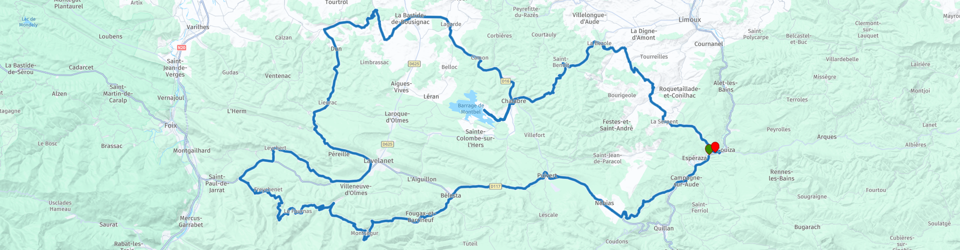
Roundtrip from Esperaza to Montsegur

This route was brought to you by:
RouteXpert Catherine De Groote RouteXpert
Last edit: 30-11-2023
 Route Summary
 The region is dotted with impressive castles and fortifications dating back to the Middle Ages. Many of these castles were used as strongholds by the Cathars during the Crusades. In addition to the historical aspects, the area also has a beautiful landscape with mountains, valleys and vineyards. It also has its own unique culture and traditions. Local festivals, markets and culinary specialties add to the charm of the region.
Today the area is a popular tourist destination, both for its historical significance and its natural beauty.
The Pays des Cathares that you cross from Espéraza is a fascinating region that attracts both history and nature lovers. It embodies the legacy of the Cathars and offers a unique look at the medieval history of southern France.
The Cathar castles of Puivert, Montségur and Roquefixade are the highlights of this ride. But the beautiful landscapes and plenty of wild nature with apparently lost traffic roads that are in good condition also give you an unforgettable day trip. Every now and then a hamlet, some meadows or a vineyard to prevent it from becoming monotonous along the way; what more could you want as a motorcyclist?
This tour gets 5 stars without a doubt.
 Share this route


Animation

Verdict


Duration
9h 17m

Mode of travel
Car or motorcycle

Distance
186.97 km

Countries

 RouteXpert Review
 You drive towards Puivert to visit the first Cathar castle on this tour. You leave the D117 and take the steep road (12%) to the castle. The castle was first mentioned in a text from the year 1170. It is best known as one of the better preserved Cathar castles in France. The location, on an accessible, relatively low hill, is less spectacular than the location of other Cathar castles such as Peyrepertuse, Montségur or Quéribus. It has retained much of its original character. The keep in particular is very well preserved. This keep has four floors, all of which are accessible. This includes the castle chapel and the famous 'salle des musiciens'. This is a room with eight sculptures of musicians. Finally, from the top of the keep you can enjoy a beautiful view of the surrounding area.
In Bélesta you leave the D117 towards Montségur. Just before entering the village, some tough hairpin bends await you.
The castle, located on a rock ridge at an altitude of 1207 m, is best known as the last refuge of the Cathars. It was besieged by the Crusaders in 1244 and surrendered after ten months of resistance. More than 200 Cathars inside the castle refused to convert to Catholicism and were burned alive. The castle is now a ruin and a major tourist attraction. Moreover, the view over the region is sublime, both over the lower parts towards the north and towards the Pyrenees.
What follows are narrow roads through forests with occasional views over the beautiful region. It is certainly never flat and there are many hairpin bends.
The castle of Roquefixade is an ancient ruin on a high cliff, above the town of Roquefixade. The castle has a rich history. According to various sources, it dates from the twelfth century, although the contemporary ruins are more modern. Although the castle's location may have once been a refuge for the Cathars during the Albigensian Crusade, the ruins date from a later period in history. The rock on which the once impressive castle was located has always been seen as an important strategic location over the centuries. It was renovated several times from the fourteenth century. In the seventeenth century, the once impressive castle was demolished on the orders of the French King Louis XIII. In 1995, the ruins of the castle were officially classified as a historic monument. Today the ruins of the castle are open to the public, accessible via a path from the nearby village. From the cliff where the ruins of Roquefixade castle are located, you can enjoy a beautiful view of the surrounding area. A visit to the impressive ruins of Roquefixade castle is definitely worthwhile.
Restaurant 'A table', when entering Lavelanet, is popular with the locals. A sign of good food. Everything is prepared with fresh ingredients. The friendly staff exudes a high degree of hospitality.
The castle of Lagarde is no longer completely intact, but a visit to this beautiful castle is more than worthwhile. The first castle consisted of a square tower and was built to protect the area against highwaymen. In the twelfth century it was further expanded with four additional towers and a gatehouse. The entire castle was also surrounded by a defensive wall. After the Albigensian Crusade, the castle fell into the hands of the Lévis-Mirepoix family. The new owners had, among other things, a drawbridge built. Despite all the defenses, the castle was severely damaged during the French Revolution. The castle has since been used as a quarry. In 1914, the castle was declared a historic monument, so it can still be visited today.
The fortified village of Camon, nicknamed Little Carcassonne and spread around its ancient Benedictine abbey, is listed as one of the most beautiful villages in France. The Clock Tower, the tall house, the city walls, the abbey castle or the 16th century church are just a few of the attractions to discover. Also known as the village with a hundred roses, Camon dresses up in countless roses from the month of May onwards. Tribute is paid to this magnificent display of flowers every year on the third Sunday in May.
In Chalabre you can enjoy a soft drink or delicious coffee on the terrace at the Bar des Sports.
A few kilometers further you come to the Montbel reservoir. The flooded hills are still visible when the water level drops, revealing tree stumps and the thick sticky clay (marl) so typical of the Ariège. On calm, warm summer days, the water turns a beautiful turquoise color, which is very photogenic. The area is relatively undeveloped and peace and privacy are a big draw. The Pyrenees mountains are visible in the background. The dam that created the reservoir was built between 1982 and 1985.
From the village of Castelreng, the forests give way to extensive Limoux vineyards. This provides beautiful views with the mountain peaks of the Pyrenees in the background.
Limoux wines are a diverse group of wines produced in the Limoux region, named after the central city of Limoux. This includes sparkling, white and red wines, made from different grape varieties and methods. Limoux is considered the oldest sparkling wine region in the world, dating back to 1531, when Benedictine monks at Saint-Hilaire Abbey discovered the method of secondary fermentation in the bottle.
This is how this fascinating, historic and scenic route is gradually coming to an end. Thanks to the small winding roads and the beautiful views, this was enjoyable from start to finish.


 Links
Links  Usage
Usage Want to download this route?
You can download the route for free without MyRoute-app account. To do so, open the route and click 'save as'. Want to edit this route?
No problem, start by opening the route. Follow the tutorial and create your personal MyRoute-app account. After registration, your trial starts automatically.  Disclaimer
Use of this GPS route is at your own expense and risk. The route has been carefully composed and checked by a MyRoute-app accredited RouteXpert for use on TomTom, Garmin and MyRoute-app Navigation.
Changes may nevertheless have occurred due to changed circumstances, road diversions or seasonal closures. We therefore recommend checking each route before use.
Preferably use the route track in your navigation system. More information about the use of MyRoute-app can be found on the website under 'Community' or 'Academy'.

Occitanie
About this region
Occitanie (French pronunciation: [ɔksitani] (listen); Occitan: Occitània [utsiˈtanjɔ]; Catalan: Occitània [uksiˈtaniə]), Occitany or Occitania (), is the southernmost administrative region of metropolitan France excluding Corsica, created on 1 January 2016 from the former regions of Languedoc-Roussillon and Midi-Pyrénées. The Council of State approved Occitanie as the new name of the region on 28 September 2016, coming into effect on 30 September 2016.The modern administrative region is named after the larger cultural and historical region of Occitania, which corresponds with the southern third of France. The region Occitanie as it is today covers a territory similar to that ruled by the Counts of Toulouse in the 12th and 13th centuries. The banner of arms of the Counts of Toulouse, known colloquially as the Occitan cross, is used by the modern region and is also a popular cultural symbol. In 2015, Occitanie had a population of 5,839,867.
Read more on Wikipedia
View region
 Statistics
  72
72Amount of RX reviews (Occitanie)
 25975
25975Amount of visitors (Occitanie)
 3641
3641Amount of downloads (Occitanie)
 Route Collections in this region
 25 Magnificent trails in France
This MRA route collection contains 25 beautiful motorcycle routes in different parts of France, such as the Ardennes, the Alsace, Vercors, the Drôme, the Ardèche, Cote d'Azure, Gorges du Verdon, the Ariège, the Dordogne and Brittany.
The routes have been carefully created by Bert Loorbach, who is an enthusiastic motorcyclist himself. He lived in France for a year and a half, during which time he devoted himself to mapping the unknown and beautiful back roads of France especially for motorcyclists.
The routes are bundled in the Motortourgids France part 1 of Kosmos publishing house and now also available in MyRouteApp.
I have taken over the routes in MRA and sometimes adjusted them slightly to make them even more interesting for the motorcyclist.
View Route Collection
24 Magnificent trails in France
It is clear that France is one of the most beautiful and best touring countries. It offers an incredibly varied landscape with good roads and a pleasant climate. It is not for nothing that you see so many motorcyclists there. My previous collection of 25 routes in France (25 Magnificent routes in France) were based on the route descriptions from the Motortourgids France part 1 made by Bert Loorbach.
This collection of 24 routes comes from Motortourgids France part 2. In this collection, a difference has been made between approach routes and motorcycle tours in a certain area. The approach routes can also be used in combination with the routes from Motortourgids France part 1
The routes are sometimes slightly adjusted based on the tips that Bert Loorbach gives in his description, or because of another place to spend the night, or to reach the minimum length of 2 hours for the MRA Library. For each route, the review contains a more detailed description, including options to stay overnight or places of interest along the way, which are also indicated with a POI and if possible with a short description.
Two or more routes have been created for a number of areas, such as for Burgundy, Auvergne, The Alps, Tarn and Cévennes and Nord-Pas de Calais. These routes can be nicely combined in a multi-day trip.
View Route Collection