Denver Aspen Three Day Round Trip

This route was brought to you by:
RouteXpert René Plücken (MRA Master)
Last edit: 12-02-2021
 Route Summary
  Share this route


Animation

Verdict


Duration
14h 23m

Mode of travel
Car or motorcycle

Distance
917.75 km

Countries

 RouteXpert Review
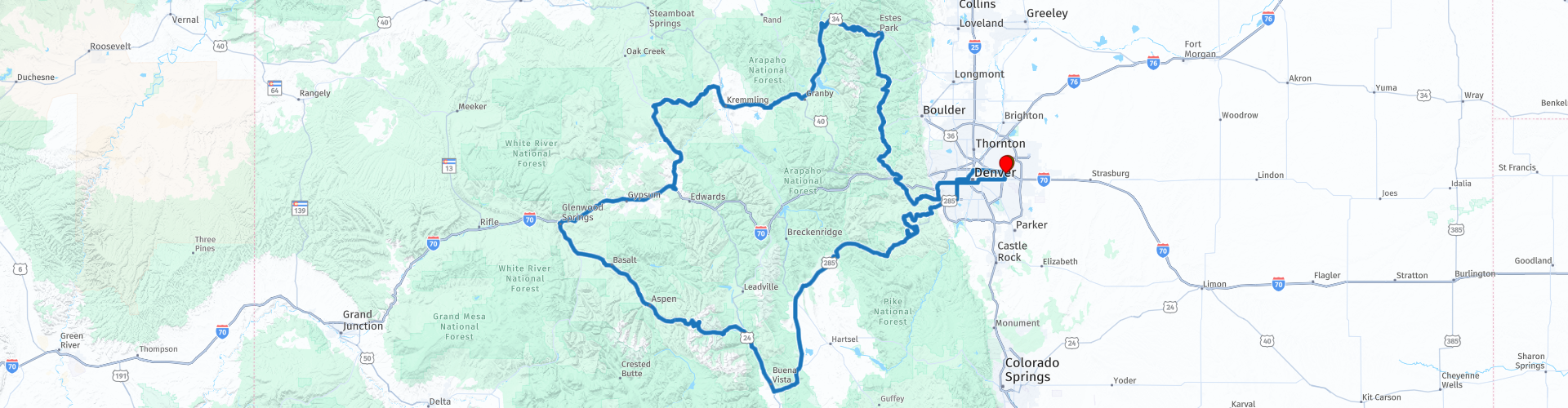
 Beautiful ride through the Colorado Mountains great twisty roads and partly highways.
I didn’t ride it myself, but created it based on information I found on a website of the Colorado Department of Transportation.
It’s a combination of Interstates, Highways and several scenic Byways in North-Central Colorado, like;
• Independence Pass (closed from October till May)
• Colorado River Headwaters Scenic Byway
• Trail Ridge Road
• Peak to Peak
• Lariat Loop
The ride starts in Denver at the Quality Inn Hotel near the Airport. Near the hotel is a Harley rental, if you want another brand you can rent a BMW or Triumph at RP3.
The roads are of good quality, but can be muddy. The view along the ride is amazing, al lot of beautiful mountain views and you’ll ride along several rivers, like the Colorado River, and lakes. You will see a lot of beautiful nature and there are a lot of interesting stops along the way, some of them are highlighted in the review and marked with a Route Point.
The ride is in total 570 mls (918 km) and planned as a three day Road trip with two overnight stays in hotels (RP13 and 22). Feel free to adjust as you like, there are multiple camp and lodging sites.
At the end of the first day or start of the second day you can choose to go Rafting and use the Zip Line at RP11, make sure plan enough time as this takes half a day.
Between Twin Lakes (RP13) and Aspen (RP18) you will ride the famous Independence Pass. This is a beautiful Mountain pass with some nice switchbacks, the elevation is 12,095 ft (3,687 m). Take your time to stop at RP14 and 15, where you can admire the view and take some pictures. At RP16 you can visit the Ghost Town Independence which served as a mining town in the 1880's. Because of the harsh and long winters and the bust of good mining opportunities, the town was eventually abandoned, with many seeking better mining opportunities in Aspen and elsewhere.
The next stop is at RP17 The Devils Punchbowl and the Grottos. The Devil’s Punchbowl, a popular cliff jumping spot, is a section of large rocks where water pools along the Roaring Fork River, if you dare you can take a jump or dive from the cliffs into the Punchbowl. The Grottos Trail is a 1.1 mile heavily trafficked loop trail that features a waterfall and is good for all skill levels. The trail offers a number of activity options and is best used from June until September.
Next town on the tour is Aspen (RP18), if you’d like you can stop here from some sightseeing.
After Aspen the ride continues alongside the Roaring Fork River to Glenwood Springs (RP19) where you can schedule a short stop for a drink and if needed to fuel up the bikes. From Glenwood Springs we will take the Interstate 70 to Wolcott. It’s about 50 mls (70km) of Interstate, but with a great scenery.
At RP20 you can plan a short stop to take pictures of the Grizzly Creek, if you have the time you can also go for a hike. Grizzly Creek is one of several tributary streams that feeds into the Colorado River. The out and back trail meanders along the creek for several miles of spectacular, towering cliffs. Easily one of the best hikes in Colorado, picnic spots and plenty of places to enjoy river views make this a popular choice for a summer outing.
In Wolcott we turn onto the Colorado State Highway 131, which is again a beautiful scenic ride through the Colorado Mountains which some nice twisty sections and beautiful views.
At RP21 you can visit the 4 Eagle Ranch where you can enjoy different types of Outdoor Activities. It’s an authentic ranch experience full of fun family activities. They provide a unique blend of outdoor activities including Zip Lining, Horseback Riding, 4×4 Jeep, and ATV tours, Wine Tasting and more.
The ride continues through the Mountains and Routt National Forest to our second overnight stop in Kremmling (RP22).
The last day of this three day road trip continues on Highway 40, the 16 mls (26 km) section from RP23 to RP24 is also called the Colorado River Headwaters Scenic Byway as it flows the banks of the Colorado River with some amazing views, so plan time to stop and enjoy.
The ride continues on the Trail Ridge Road, another scenic Byway, through the Rocky Mountains, with a stop at the Forest Canyon Overlook (RP26), where you can enjoy the amazing view of the Rocky Mountains.
You can stop at the Beaver Meadows Visitor Center (RP27) to view the short Park Orientation Film. Information about the Park and its interpretive activities, maps, and books are also available. The central office for back country camping reservations is reached by a footpath to a small building just east of the Headquarters.
On our way back we’ll ride the scenic Peak To Peak Highway (RP28-31), established in 1918 this is Colorado's oldest scenic byway. We will have a lunch break in the town Nederland (RP30). For Dutch travellers it’s a tip to take a picture at the Road Sign (RP29).
Via nice twisty road we continue the ride to Black Hawk (RP32), which is one of Colorado's top destinations with a lot of Casino's, over a Dozen Hotels and Countless Restaurants.
Next interesting stop to take some pictures, and if you want go for a short hike, is the Cleer Creek Greenway (RP34). The ride continues along a part of the Lariat Loop Scenic & Historic Byway (RP33-37). You can have a short stop to take a picture of Evergreen Lake (RP35). You can stop to have dinner at the end of the Lariat Loop in Morrison (RP37) or continue the ride and plan dinner in one of the many restaurants in Down town Denver.
I rate this tour with 5 Stars as it combines so many beautiful roads, scenery and interesting activities


 Links
Links  Usage
Usage Want to download this route?
You can download the route for free without MyRoute-app account. To do so, open the route and click 'save as'. Want to edit this route?
No problem, start by opening the route. Follow the tutorial and create your personal MyRoute-app account. After registration, your trial starts automatically.  Disclaimer
Use of this GPS route is at your own expense and risk. The route has been carefully composed and checked by a MyRoute-app accredited RouteXpert for use on TomTom, Garmin and MyRoute-app Navigation.
Changes may nevertheless have occurred due to changed circumstances, road diversions or seasonal closures. We therefore recommend checking each route before use.
Preferably use the route track in your navigation system. More information about the use of MyRoute-app can be found on the website under 'Community' or 'Academy'.
a.jpg/800px-Maroon_Bells_(11553)a.jpg)
Colorado
About this region
Colorado is a state in the Mountain West subregion of the Western United States. It encompasses most of the Southern Rocky Mountains as well as the northeastern portion of the Colorado Plateau and the western edge of the Great Plains. Colorado is the eighth most extensive and 21st most populous U.S. state. The 2020 United States Census enumerated the population of Colorado at 5,773,714, an increase of 14.80% since the 2010 United States Census.
The region has been inhabited by Native Americans for more than 13,000 years, with the Lindenmeier Site containing artifacts dating from approximately 9200 BC to 1000 BC; the eastern edge of the Rocky Mountains was a major migration route for early peoples who spread throughout the Americas. "Colorado" is the Spanish adjective meaning "ruddy," the color of red sandstone. The Territory of Colorado was organized on February 28, 1861, and on August 1, 1876, U.S. President Ulysses S. Grant signed Proclamation 230 admitting Colorado to the Union as the 38th state. Colorado is nicknamed the "Centennial State" because it became a state one century after the signing of the United States Declaration of Independence.
Colorado is bordered by Wyoming to the north, Nebraska to the northeast, Kansas to the east, Oklahoma to the southeast, New Mexico to the south, Utah to the west, and touches Arizona to the southwest at the Four Corners. Colorado is noted for its vivid landscape of mountains, forests, high plains, mesas, canyons, plateaus, rivers, and desert lands. Colorado is one of the Mountain States and is a part of the western and southwestern United States.
Denver is the capital and most populous city in Colorado. Residents of the state are known as Coloradans, although the antiquated "Coloradoan" is occasionally used. Colorado is a comparatively wealthy state, ranking eighth in household income in 2016, and 11th in per capita income in 2010. It also ranks highly in the nation's standard of living index. Major parts of the economy include government and defense, mining, agriculture, tourism, and increasingly other kinds of manufacturing. With increasing temperatures and decreasing water availability, Colorado's agriculture, forestry and tourism economies are expected to be heavily affected by climate change.
Read more on Wikipedia
The region has been inhabited by Native Americans for more than 13,000 years, with the Lindenmeier Site containing artifacts dating from approximately 9200 BC to 1000 BC; the eastern edge of the Rocky Mountains was a major migration route for early peoples who spread throughout the Americas. "Colorado" is the Spanish adjective meaning "ruddy," the color of red sandstone. The Territory of Colorado was organized on February 28, 1861, and on August 1, 1876, U.S. President Ulysses S. Grant signed Proclamation 230 admitting Colorado to the Union as the 38th state. Colorado is nicknamed the "Centennial State" because it became a state one century after the signing of the United States Declaration of Independence.
Colorado is bordered by Wyoming to the north, Nebraska to the northeast, Kansas to the east, Oklahoma to the southeast, New Mexico to the south, Utah to the west, and touches Arizona to the southwest at the Four Corners. Colorado is noted for its vivid landscape of mountains, forests, high plains, mesas, canyons, plateaus, rivers, and desert lands. Colorado is one of the Mountain States and is a part of the western and southwestern United States.
Denver is the capital and most populous city in Colorado. Residents of the state are known as Coloradans, although the antiquated "Coloradoan" is occasionally used. Colorado is a comparatively wealthy state, ranking eighth in household income in 2016, and 11th in per capita income in 2010. It also ranks highly in the nation's standard of living index. Major parts of the economy include government and defense, mining, agriculture, tourism, and increasingly other kinds of manufacturing. With increasing temperatures and decreasing water availability, Colorado's agriculture, forestry and tourism economies are expected to be heavily affected by climate change.
View region
 Statistics
  20
20Amount of RX reviews (Colorado)
 14771
14771Amount of visitors (Colorado)
 329
329Amount of downloads (Colorado)
 Route Collections in this region
 Coast to Coast Across the USA
14 Days across the USA
Start the trip at Daytona Pier on the Atlantic Coast.
Through 14 days you will visit New Orleans, Memphis, Tulsa, Colorado Springs, Las Vegas and Los Angeles. See the sights of Monument and Death Valley, the Hoover Dam. Ride across 12 US States for 4267 miles of adventure before ending the trip on Santa Monica Pier, Los Angeles on the Pacific Coast
View Route Collection
The 10 most downloaded routes in the USA from RouteXpert Hans van de Ven
Hello and welcome to this collection of the Top 10 MyRoute app downloaded routes in USA.
There will be a great new event to be announced soon, where all these routes can be driven.
Download them all now and place them in a new "Top 10" folder, so that you always have them at hand.
If you are going to drive one of these routes in the meantime, track them with the MRA Mobile App or with MRA Navigation. Take some photos (moments) along the way as these will come in handy.
Create a travelogue of your Top 10 driven routes and add the recorded track to it.
There will also be some great prizes on offer, so keep an eye on the MRA-RouteXperts page and your mail.
The 10 routes are:
1. D13 Estes Park Denver
2. D03 Chadron Custer
3. D01 Pigeon Forge round trip through the Smokey Mountains
4. D08 Kalispell Sandpoint
5. D10 Colville Wenatchee
6. D09 Sandpoint Colville
7. D04 Custer Wall
8. D11 Wenatchee Seattle
9. D08 Cody Yellowstone NP
10.R13 San Francisco Monterey
View Route Collection